2026 Bucket List Hikes In Michigan With No Permit Required And Huge Scenic Reward
As a regular on these trails, I can tell you that my best gear isn’t a high-end GPS, it’s a simple pair of broken-in boots and the knowledge that Michigan’s greatest hits don’t require a permit or a mountain of paperwork.
The real secret to hiking this state is the “effort-to-view” ratio. You can find jaw-dropping Lake Superior overlooks or limestone canyons in just a mile or two of walking.
While others are busy planning overseas treks, I’m out here soaking in the thundering spray of a hidden falls for the grand total of zero dollars. It’s the smartest investment you’ll make in 2026.
These are 12 best hiking trails in Michigan for 2026, featuring scenic waterfall hikes, towering sand dunes, and free outdoor adventures across the Upper and Lower Peninsulas.
I’ve narrowed down the twelve spots that pack the most punch for your pulse, and I promise they’ll surprise even the most seasoned hikers.
1. Empire Bluff Trail
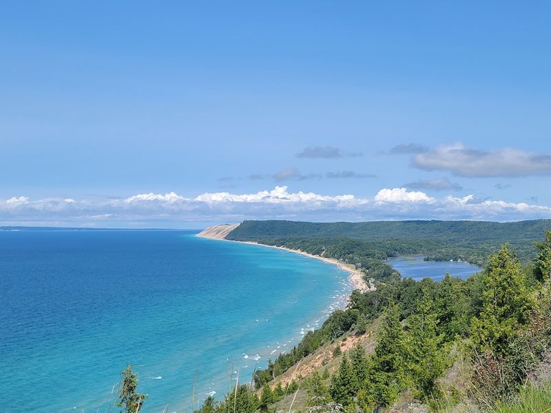
Standing at the top of Empire Bluff Trail feels like the earth just decided to show off, and it hits you fast. The trail is only about 1.5 miles round trip, but the payoff is a sweeping view of Lake Michigan and the Sleeping Bear Dunes that genuinely stops you mid sentence.
The bluff sits within Sleeping Bear Dunes National Lakeshore, which was famously named the most beautiful place in America by Good Morning America back in 2011. That title still holds up, and the views seem to get better every year as the wind reshapes the landscape.
The path winds through a quiet beech maple forest before opening onto an exposed overlook where the sand dunes tumble dramatically toward the water below. It’s a relatively easy climb, but the elevation gain is enough to get your heart pumping before that final boardwalk.
Arrive early on weekends to snag a parking spot at the trailhead off Wilco Road near Empire, because this is no longer a hidden secret. If you can, aim for a sunset visit, watching the sun dip into the horizon from this height is legendary, and it makes the hike back feel like part of the scene.
2. Pyramid Point Trail
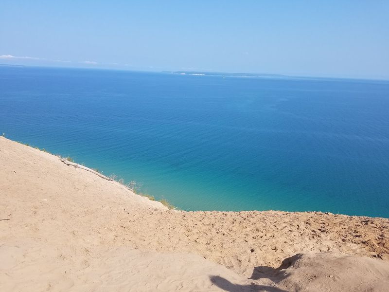
If Empire is the popular sibling, Pyramid Point Trail is the one with the wilder, slightly more adventurous spirit. It earns its name from the high, triangular plateau that juts out into Lake Michigan like a prow.
From the top, the drop below is steep enough to make your knees do a little negotiating with your brain, and the feeling is real. The full loop runs about 2.7 miles through hardwood forest, meadows, and open dune terrain, so you get variety built in.
What makes this trail stand out is the genuine sense of height you feel at the overlook, it does not feel small. The shoreline curves away in both directions, and on a clear day you can spot North Manitou Island and South Manitou Island floating on the horizon like ancient green giants.
The trailhead sits off Port Oneida Road, north of Glen Arbor, and it’s worth coming prepared. Bring plenty of water, because once you leave the trailhead there are no facilities or water pumps, and the initial climb is a true lung buster.
Take your time and enjoy the meadow views before you hit the forest canopy, because that pacing makes the whole loop feel better.
3. Miners Castle Overlook Trail
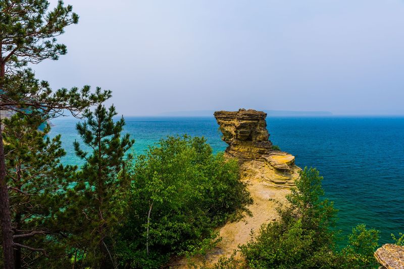
The sandstone walls at Miners Castle Overlook Trail have been shaped by Lake Superior for thousands of years, and they look like something a geologist would dream about on a very good night. Two castle like rock turrets jut out over the water, and the lake below shifts from jade green near shore to a deep, intimidating navy farther out.
Pictured Rocks National Lakeshore protects this stretch of shoreline, and it earns the reverence it gets. While the castle lost one of its turrets to erosion in 2006, the remaining structure is still one of the most iconic sights in the Upper Peninsula.
The geological story is wild, the colorful streaks on the cliffs come from iron, copper, and manganese leaching through the rock over centuries. It creates a natural mural that shifts with the light, so the same viewpoint can look different hour to hour.
Parking at the Miners Castle lot fills up fast in July and August, so early morning is worth the alarm. If you have the energy, take the stairs down to the lower overlook for a closer look at the rock layers and the true scale.
4. Miners Falls Trail
Not far from the castle turrets lies Miners Falls Trail, where the water drops about 40 feet into a rocky gorge. The sound reaches you well before the view, a low rumble that builds as you navigate the 1.2 mile trek one way.
The path passes through a dense northern forest that stays remarkably cool even on humid summer afternoons. This is the kind of hike where you breathe in cedar and damp earth, and you feel the temperature drop with every step toward the gorge.
What surprises most people is how wide the falls are, because it is not a thin ribbon trickling down a cliff. Miners Creek spreads out before the drop, creating a broad curtain effect that photographs beautifully in morning light when the shadows stay soft.
The viewing platform puts you at a comfortable distance with no scrambling required, so it works for a wide range of hikers. Since the trailhead shares a parking area with the road leading to the coast, plan both stops in one visit for maximum efficiency.
5. Chapel Falls Trail
For those who want to feel like they’ve truly disappeared into the woods, Chapel Falls Trail is a must. This waterfall is the kind that makes people stop talking, dropping roughly 60 feet in a clean, narrow ribbon into a pool framed by mossy boulders and old growth hemlocks.
The atmosphere is hushed in a way that feels almost deliberate, like the forest is protecting a secret. The trail runs about 1.7 miles one way from the Chapel Road trailhead and stays relatively flat, so the dramatic finale feels like a genuine surprise.
Some hikers extend the trip into a longer ten mile loop that also visits Chapel Lake and the famous Chapel Rock. Chapel Rock is a sea arch perched above Lake Superior, with a lone pine tree growing on top, and it is as iconic as people say.
Be prepared for a bumpy ride on the access road, it’s gravel and can be quite pitted, so take it slow. That small inconvenience is part of the price of getting somewhere that still feels genuinely tucked away.
6. Tahquamenon Falls Upper Falls Trail
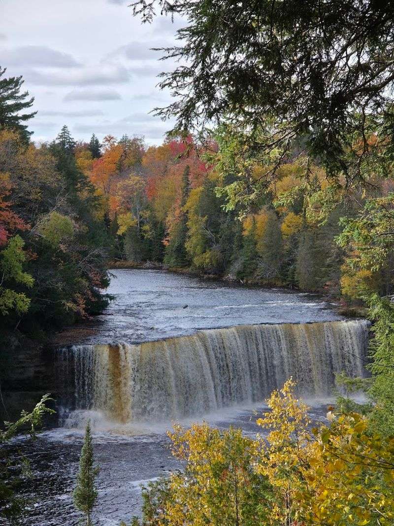
The tannins from cedar and spruce roots give the Tahquamenon River its famous root beer color, and nowhere is that more striking than at the Tahquamenon Falls Upper Falls Trail. At over 200 feet wide and nearly 50 feet tall, this is one of the largest waterfalls east of the Mississippi River, and it earns that claim without any argument.
The sheer volume of water creates a thunderous roar and a mist you can feel on your face long before you see the drop. At times it moves over 50,000 gallons per second, which is why the sound and spray feel so intense.
The trail from the parking area to the main overlook is short and paved, making the headline view easy to reach.
Tahquamenon Falls State Park surrounds the area, and the forest here feels genuinely old and deep. Autumn visits are spectacular because the amber water matches the changing leaves, while summer draws big crowds and tighter parking.
No permit is needed for the hike, though you’ll want your Michigan Recreation Passport on your windshield for vehicle entry to avoid a ticket.
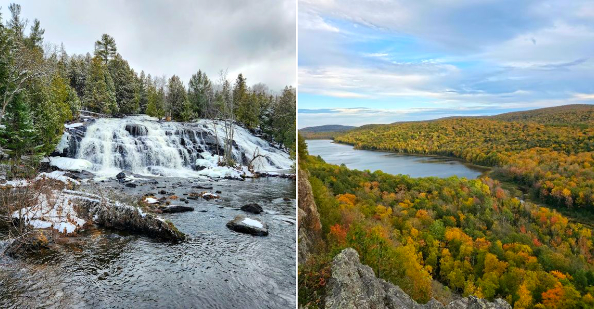
7. Bond Falls Scenic Site Trail
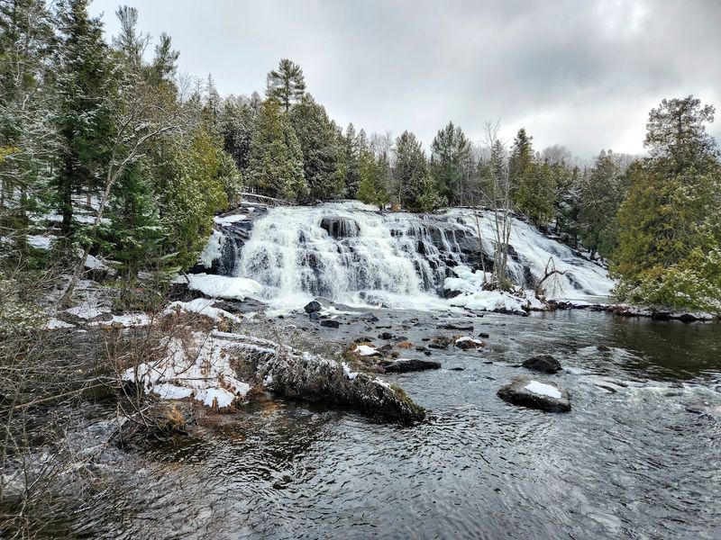
If Tahquamenon is the power waterfall, Bond Falls Scenic Site Trail is the beauty waterfall. This is the spot photographers keep quietly to themselves, and the reputation is earned the second you see the water.
The Ontonagon River fans out over stepped basalt ledges, creating a wide, layered cascade that looks almost too photogenic to be real. It’s less of a single drop and more of an elegant staircase of water that keeps revealing new lines.
A well maintained boardwalk loops around the falls and crosses the river on a footbridge, giving you multiple angles without technical scrambling. The whole walk is under a mile, so it’s an easy stop even if you are not a dedicated hiker.
Bond Falls Flowage, the reservoir upstream, adds to the approach and the mood. You might spot bald eagles or ospreys, and the open water makes the area feel bigger than a quick boardwalk suggests.
The site is managed by the Upper Peninsula Power Company but remains publicly accessible year round. Peak flow typically happens in late May and early June, and winter brings frozen formations that are equally stunning if you can handle the cold.
8. Lake Of The Clouds Overlook Trail
There is a reason the Lake Of The Clouds Overlook Trail is one of the most photographed spots in the state. From the main overlook at Porcupine Mountains Wilderness State Park, the view stretches over an unbroken canopy of old growth forest cradling a narrow blue lake in the valley below.
It looks more like a scene from the Canadian Rockies than the Midwest, and it makes you feel small in the best way possible. The stillness and scale do the work, you do not need a special angle or a special moment.
The overlook itself is a short, accessible walk from the parking area, which makes it easy to fit into almost any day. If you want a longer experience, the Escarpment Trail follows the ridgeline east and delivers continuously dramatic views for several miles.
The Porcupine Mountains contain one of the largest remaining old growth forests in the eastern United States. That gives the landscape a weight and quiet presence that newer forests simply do not have.
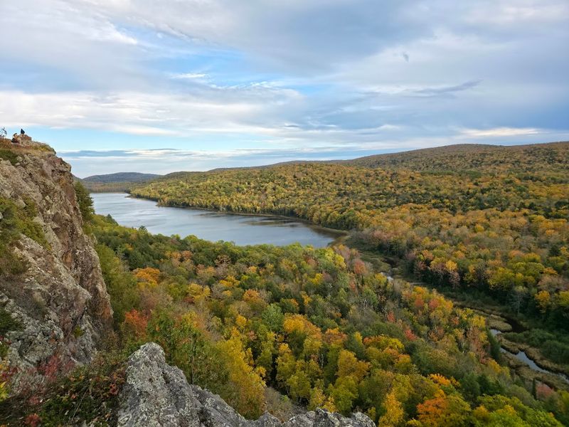
9. Summit Peak Trail
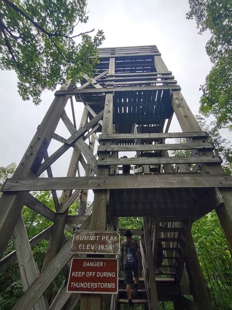
While most people flock to Lake Of The Clouds, savvy hikers head over to Summit Peak Trail. This is the highest point in the Porcupine Mountains, and the observation tower adds enough height to push the view past the treetops toward Lake Superior on a clear day.
The hike from the trailhead is about 1.6 miles round trip, gaining elevation steadily without being brutal. It’s a well designed path that uses boardwalks to carry you through the more rugged sections.
The tower is a simple wooden structure that creaks satisfyingly in the wind, which somehow adds to the mountain man feeling. On calm autumn mornings, the forest below becomes a patchwork of red, orange, and yellow that stretches as far as your eye can follow.
This trail pairs naturally with the more famous lake overlook, since both are within Porcupine Mountains Wilderness State Park. You can combine them into a rewarding half day outing without feeling like you are sprinting through the park.
It’s a bit of a drive to reach this section, but the lack of crowds often makes it worth every mile. If you want space and a long view, this is the one that tends to deliver.
10. Sugarloaf Mountain Trail
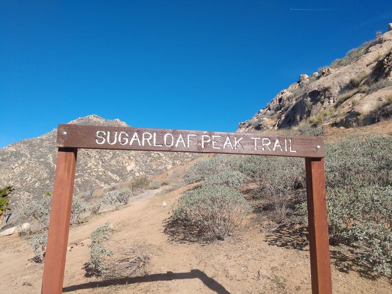
Located just north of Marquette, the Sugarloaf Mountain Trail is a local favorite that hits the sweet spot between a casual walk and a rewarding climb. The trail gains about 300 feet over roughly 0.7 miles, passing through birch and spruce forest before breaking out onto a bare rocky summit.
There are two paths, the easy and the difficult, and it’s useful to plan your legs. The difficult route on the way up is just a few more stairs and steeper grades, and the easy route on the way down is kinder to your knees.
From the top, Lake Superior fills the northern horizon with a blue so deep it almost looks painted. The city of Marquette spreads out below to the south, and on clear days you can see the Huron Mountains rising in the distance.
It’s the kind of view that recalibrates your sense of scale, because it makes the city feel small and the lake feel endless. The parking area off County Road 550 is free, the trail is open year round, and the summit rocks make a genuinely excellent lunch spot.
It’s a perfect move to grab a local pasty in town and hike it up for a picnic.
11. Rosy Mound Natural Area Trail
The Lower Peninsula gets to show off its dramatic side at the Rosy Mound Natural Area Trail. Managed by Ottawa County Parks, this natural area features a loop of about 2.2 miles that climbs through forested dunes before delivering an open view over Lake Michigan from a high sandy ridge.
This isn’t just a walk on the beach, it’s a trek through a unique ecosystem with real texture. Boardwalk sections through the dune swale protect fragile marram grass and wildflowers that stabilize the sandy terrain.
If you visit in spring, you can catch blooming trout lilies and trilliums tucked beneath the cottonwoods. Those small details make the walk feel alive before you even reach the big lake view.
The descent to the beach is steep and involves a lot of stairs, which is fun on the way down and a workout on the way back up. No permit is needed to hike, though a small parking fee applies at the Ottawa County lot off Lakeshore Drive in Grand Haven Township.
It’s a small price for a well maintained and genuinely breathtaking escape from the suburban sprawl. Bring water and give yourself time, because the stairs change the pace more than the mileage suggests.
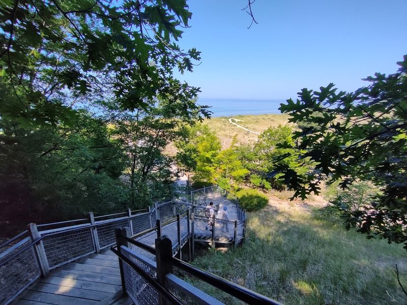
12. Mount Baldhead Park Trail

Four hundred and some steps lead to the top of Mount Baldhead Park Trail in Saugatuck, and yes, you will feel every single one. The wooden staircase climbs one of the highest dunes on the eastern shore of Lake Michigan, and the burn is part of the ritual.
The view from the summit platform makes the effort feel like a reasonable trade, and it’s a rite of passage for visitors. You get that instant, wide angle sense of coastline that only a high dune can give.
Saugatuck has long been a beloved arts community, and the town’s creative, unhurried energy carries right up the trail with you. From the summit, the Kalamazoo River mouth, Oval Beach, and the open lake spread out in a single panoramic sweep.
Once you catch your breath, you can take the trail down the back side of the dune directly to the beach, which is much easier than reversing the stairs. The trailhead is accessible from the Saugatuck Chain Ferry crossing, a famous tradition in itself, or by road through the city park.
Early morning visits on summer weekdays are the way to go, you’ll get soft light and a cool breeze before midday heat settles in.