15 September Drive Routes In Oregon With Wow Views, According To Locals
September in Oregon brings crisp mornings, clear horizons, and reliable access to high country roads. Smoke often fades, trailheads quiet after Labor Day, and viewpoints stretch for miles.
These routes favor paved corridors with easy pullouts, lakeshore loops, and waterfall clusters. Drivers find updated signage, seasonal gates mostly open, and visitor centers operating regular hours. Each entry notes what people see, how the route flows, and why September suits it.
Expect a mix of coast, Cascades, and high desert. Pack layers, check TripCheck, and enjoy daylight that still lasts.
1. Pacific Coast Scenic Byway
Sea stacks frame Highway 101 as the road slips between towns and headlands. Visitors find wide beaches, tide pools, and quick stops signed along the shoulder. Waysides appear often.
The byway traces Oregon’s full coastline on US 101, connecting lighthouses, fishing harbors, and state parks. Pullouts mark whale lookouts and beach access paths. Towns offer services year-round.
September usually delivers stable marine layers and fewer peak crowds. Drivers monitor TripCheck for construction and coastal wind advisories, then plan short walks at signed turnouts for safe viewing.
2. Three Capes Scenic Route
Clifftop views arrive in bursts between Cape Meares, Cape Lookout, and Cape Kiwanda. Visitors often pause at overlooks for surf, sea birds, and sandstone headlands.
This loop branches from 101 near Tillamook, then rejoins the highway after Pacific City. Short trails lead to viewpoints, and beach lots serve quick sand walks.
Clear September days reward sunrise and late-afternoon stops. Local guides note the loop’s manageable length and recently improved sections near Cape Meares, helping drivers link viewpoints without backtracking.
3. Historic Columbia River Highway Scenic Byway
Roadside waterfalls appear every few minutes. Travelers see basalt walls, stone guardrails, and tight curves built for scenery, not speed.
Opened in 1916, the nation’s first planned scenic highway parallels the river and I-84, passing Multnomah, Wahkeena, and other falls. Portions were restored after storm repairs in 2025.
Parking near Multnomah Falls fills quickly. Timed permits are not required on the Historic Highway in 2025, but I-84 access used timed permits in peak summer. Check ReadySetGorge and TripCheck before departure.
4. Mt. Hood Scenic Byway
Orchards, timber stands, and glacial views ring Oregon’s highest peak. Pullouts frame Mount Hood above valleys glowing with late-summer harvest.
The loop circles through Hood River Valley and Government Camp, linking fruit stands, trailheads, and historic lodges. It holds National Scenic Byway status for geologic and cultural features.
Travel Oregon lists it as a roughly 105-mile circuit, drivable year-round in good weather. September brings fewer snow hazards, though mountain showers remain possible. Monitor conditions and carry layers.
5. Marys Peak to Pacific Scenic Byway
Coast Range forests open to vistas from the range’s highest summit. Visitors often note meadow views that stretch from Cascades to Pacific.
This newer route follows OR 34 along the Alsea River from Philomath toward the Central Coast. A spur climbs Marys Peak, elevation 4,097 feet, with signed day-use areas.
September access is typically straightforward on paved approaches. Drivers confirm gate status for summit roads and plan stops at signed viewpoints before continuing west toward beaches.
6. Cascade Lakes Scenic Byway
Mirror-surfaced lakes reflect Bachelor and the Sisters on calm mornings. Picnic pullouts and day-use docks line the shore.
The drive leaves Bend and loops past Elk, Sparks, and Devils lakes through Deschutes National Forest. Visitor information appears at the Cascade Lakes Welcome Station near milepost seven.
This is a seasonal highway, generally open in summer and early fall. September brings cool nights and open campgrounds, with fewer mosquitoes. Check for early snowfall before committing.
7. McKenzie Pass–Santiam Pass Scenic Byway
Lava fields surround the road near Dee Wright Observatory. Drivers remark on black rock vistas and Cascade panoramas.
The 82-mile figure-eight combines OR 242 and US 20 between Sisters and the McKenzie River, linking waterfalls, hot springs areas, and high volcanic terrain.
OR 242 is seasonally gated. ODOT notes typical closure from November to mid-June, so September is within the open window. Verify gate status and expect narrow, winding pavement over the pass.
8. West Cascades Scenic Byway
River canyons and mossy fir forests line this long route. Visitors often see fish ladders, covered bridges, and calm reservoirs.
The drive runs roughly 215 to 220 miles on the west slope, connecting Willamette and Mt. Hood National Forest highlights with frequent recreation turnouts.
Best season is spring through fall. September offers steady weather and lower water levels that reveal rock bars and shoreline paths. Allow a full day and plan fuel stops.
9. Rogue-Umpqua Scenic Byway
Waterfall signage cues short walks to misty viewpoints. Travelers photograph columnar basalt, canyon bends, and blue pools.
Also called the Highway of Waterfalls, the corridor links Roseburg to Prospect past Watson Falls at 272 feet, Toketee Falls, and lakes on the North Umpqua.
Trails are well marked from Highway 138 pullouts. September reduces crowding and keeps flows clear. Always check trail advisories after storms and carry a day-use pass where posted.
10. Volcanic Legacy Scenic Byway
Crater Lake’s rim overlooks anchor the northern leg. Visitors watch color shift across the caldera as clouds pass.
This All-American Road spans Oregon to California, tying Crater Lake National Park to Lassen Volcanic National Park with wetlands, ranchlands, and cinder landscapes.
September typically keeps Rim Drive and overlooks open subject to early storms. Confirm gate and construction updates before committing to high-elevation side trips.
11. Hells Canyon Scenic Byway
Big-sky ranch country gives way to Wallowa peaks and deep canyon views. Travelers often stop in Joseph for galleries and bronze art.
The loop encircles the Wallowas and accesses vistas of America’s deepest river gorge. It carries All-American Road designation for outstanding scenery and culture.
Late summer through early fall is prime. September offers cool air and clear views from high lookouts. Services thin between towns, so plan fuel and food stops carefully.
12. Journey Through Time Scenic Byway
Painted Hills glow at golden hour. Drivers see stratified reds, golds, and blacks that change with light.
This 286-mile route rolls from Biggs Junction to Baker City through John Day Fossil Beds units, mining towns, and ranch country. Distances between units are well posted.
September reduces heat in the canyons. Visitors check NPS pages for unit distances and services, then stage stops to avoid midday glare on the hills’ colors.
13. Outback Scenic Byway
Open desert horizons dominate this drive. Expect rimrock cliffs, alkali flats, and long straightaways.
The route runs 171 miles along US 395 and OR 31 between New Pine Creek and La Pine, passing Fort Rock, Summer Lake, and Lakeview.
Early fall temperatures favor sightseeing at roadside viewpoints. Services are sparse, so travelers fuel up in towns and carry extra water.
14. Steens Mountain Loop Road
Aspen pockets turn early color above broad gorges. Visitors look into Kiger, Big Indian, and Wildhorse from signed overlooks.
This 52-mile backcountry byway climbs from 4,200 to about 9,700 feet on gravel and paved sections within the Steens Mountain management area.
Seasonal gates usually open late spring through early winter, weather dependent. September is commonly accessible. Expect washboard stretches and check current gate status before heading up.
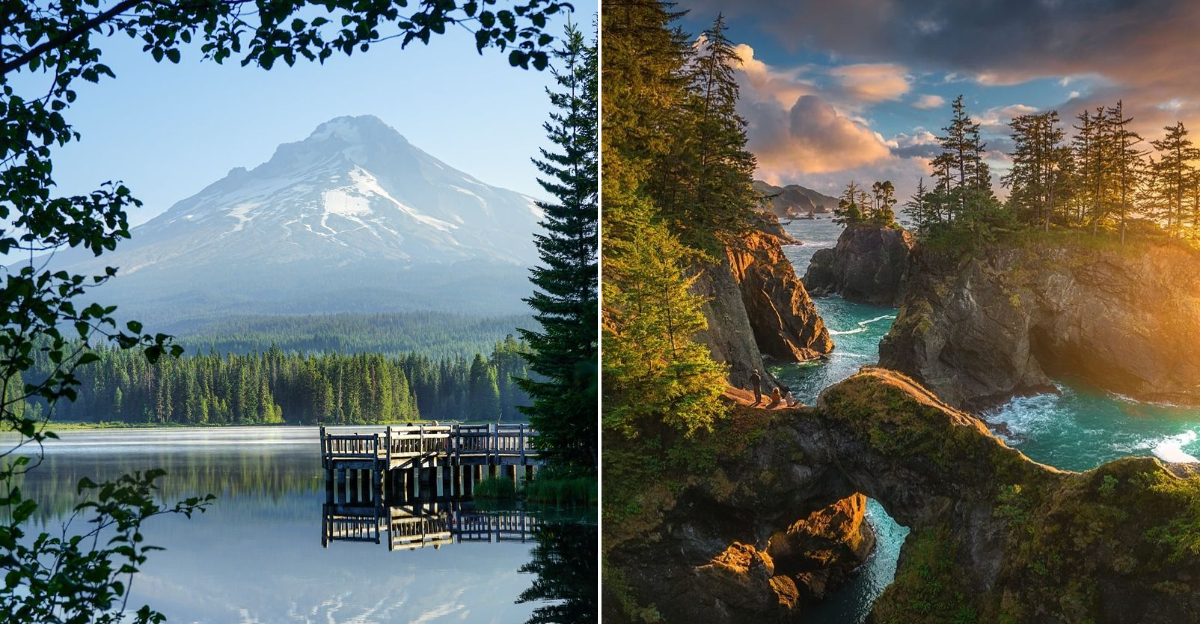
15. Samuel H. Boardman State Scenic Corridor
Sea arches and coves line a 12-mile forested shoreline between Brookings and Gold Beach. Visitors find short trails to cliff-edge viewpoints.
The corridor functions as a string of pullouts, each leading to beaches, arches, or headlands. Highlights include Natural Bridges, Arch Rock, and Cape Ferrelo.
Parking lots are small and fill on sunny afternoons. September light flatters seastacks near sunset. Oregon State Parks brochures outline hikes from quarter-mile loops to longer sections.