These Are 10 Scenic Backroads In California You Need To Drive At Least Once
California’s landscape is filled with quiet roads that slip past forests, coastlines, and mountain ridges few travelers ever reach. These lesser-known routes carry you through places where redwoods touch the sky, waves crash against empty shorelines, and high desert stretches for miles.
Each turn reveals a new view, untouched and wild, far from city noise and crowds. The drives are peaceful, sometimes challenging, always beautiful.
They invite you to slow down, roll the windows down, and experience the quieter side of California’s natural beauty, one mile at a time.
1. Mattole Road (Humboldt County)
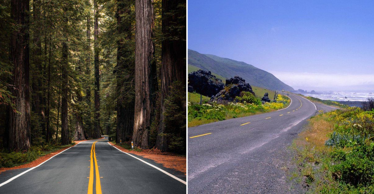
Winding through the Lost Coast, this remote stretch feels like driving through a forgotten world. Mattole Road connects Ferndale to Petrolia, passing through dense forests and open grasslands where elk roam freely.
The Pacific Ocean appears suddenly around corners, crashing against black sand beaches far below. Cell service disappears quickly, so download maps beforehand and fill your gas tank.
Pack snacks because towns are few and far between on this isolated route. The journey takes about two hours without stops, but you’ll want to pull over constantly for photos.
2. Ebbetts Pass (State Route 4, Sierra Nevada)
State Route 4 climbs to over 8,700 feet, making it one of California’s highest mountain passes. Sharp switchbacks and narrow lanes keep drivers alert while granite peaks tower on both sides.
Alpine meadows burst with wildflowers during summer months, creating carpets of purple and yellow across the landscape. Snow closes this route from November through May, so plan your trip accordingly.
Small mountain communities dot the road, offering local charm and homemade pie at roadside cafes. Calaveras Big Trees State Park makes an excellent stopping point to stretch your legs among giant sequoias.
3. Mulholland Highway (Santa Monica Mountains)
Motorcyclists and sports car enthusiasts flock to this twisting ribbon of asphalt for good reason. Mulholland Highway delivers incredible views of both the Pacific Ocean and San Fernando Valley from various lookout points.
The famous Rock Store has served as a biker hangout since 1961, where riders gather on weekends to swap stories. Curves come fast and frequent, so keep your eyes on the road despite the tempting scenery.
I’ve driven this route dozens of times and still discover new vista points each trip. Spring brings green hillsides dotted with wildflowers before summer turns everything golden brown.
4. Avenue Of The Giants (SR 254 In Humboldt Redwoods)
Driving beneath ancient redwood trees that have stood for over a thousand years creates an almost spiritual experience. This 31-mile route parallels Highway 101 through Humboldt Redwoods State Park, where the world’s tallest trees form a living cathedral overhead.
Sunlight filters through branches hundreds of feet above, creating spotted patterns on the road surface. Pull into numerous groves where you can walk among these gentle giants and feel incredibly small.
The Shrine Drive-Thru Tree offers a quirky photo opportunity that kids absolutely love. Traffic moves slowly here, which is perfect for soaking in the peaceful atmosphere.
5. Big Sur Coast Highway (Portion Of State Route 1)
Cliffs plunge dramatically into turquoise waters along this legendary coastal stretch between Carmel and San Simeon. Every curve reveals another postcard view that makes you want to stop and stare at the crashing waves below.
Bixby Bridge stands as an engineering marvel and one of the most photographed spots in California. McWay Falls tumbles directly onto a pristine beach, creating a scene that seems almost too perfect to be real.
Fog can roll in without warning, transforming the drive into a mysterious adventure through clouds. Give yourself a full day because rushing through Big Sur would be a crime against nature.
6. Angeles Crest Highway (State Route 2)
Escaping Los Angeles heat becomes easy when you climb into the San Gabriel Mountains on this spectacular highway. Angeles Crest Highway gains over 6,000 feet in elevation, trading smoggy city views for pine forests and crisp mountain air.
Countless hiking trailheads provide access to wilderness areas where black bears and mountain lions still roam wild. Winter brings snow to higher elevations, sometimes closing sections until late spring.
Last summer I pulled over at Dawson Saddle and spotted a family of deer grazing peacefully beside the road. The contrast between urban sprawl below and untamed wilderness above feels almost surreal on clear days.
7. Sierra Heritage Scenic Byway
Gold Rush history comes alive along this route connecting Nevada City to Sierra City through historic mountain towns. Old mining equipment rusts beside the road, telling stories of fortune seekers who flooded these hills in 1849.
Downieville offers excellent mountain biking trails if you need to burn some energy after sitting in the car. The Yuba River runs clear and cold, perfect for cooling off during hot summer afternoons.
Autumn transforms aspens into brilliant gold, creating a photographer’s paradise against evergreen backdrops. Small museums and preserved buildings let you step back in time to California’s wildest era.
8. Feather River Scenic Byway
Following the Middle Fork of the Feather River, this byway showcases stunning canyon scenery that rivals more famous California destinations. Highway 70 carves through the Sierra Nevada, passing through tunnels blasted into solid rock by railroad workers over a century ago.
The river churns white and wild during spring snowmelt, attracting kayakers and rafters seeking thrills. Bald eagles nest along this corridor, especially near Lake Oroville where fish are plentiful.
Small towns like Quincy maintain authentic mountain character without tourist crowds overwhelming local businesses. Fall colors peak in October when maples and oaks paint the canyon walls in warm tones.
9. Ancient Bristlecone Scenic Byway (Route 168)
Route 168 climbs to the White Mountains where the oldest living trees on Earth have survived for over 4,000 years. These gnarled bristlecone pines look more like driftwood sculptures than living organisms, yet they continue growing at extreme elevations.
The landscape feels more like Mars than California, with barren slopes and twisted trees creating an otherworldly atmosphere. Thin air at 10,000 feet makes hiking challenging, so take your time exploring the groves.
Patriarch Grove features the world’s largest bristlecone pine, a massive specimen that predates the pyramids. Bring warm layers because temperatures drop quickly even during summer months at this altitude.
10. Buckhorn Back Country Byway
Rough dirt roads lead adventurous drivers through the Carrizo Plain National Monument, where California looks like it did centuries ago. Springtime transforms this seemingly barren landscape into a wildflower wonderland that stretches to every horizon.
Pronghorn antelope sprint across open grasslands, reaching speeds that make your car feel slow. The Temblor Range rises sharply on the western edge, creating dramatic backdrops for sunset photography.
Four-wheel drive isn’t always required, but high clearance helps navigate washboard sections and occasional mud after storms. Solitude comes easy here since most travelers stick to paved highways instead of exploring this hidden gem.