This Maine Ridge Lookout Locals Swear Hides The Region’s Best View
Imagine pulling off a quiet stretch of highway in western Maine and stepping onto a gravel overlook where the air feels light enough to lift you. Below, the Rangeley Lakes shimmer like glass, reflecting clouds that drift without hurry.
Beyond them, Mooselookmeguntic Lake opens wide, Toothaker Island anchors the view, and the mountains rise in soft, steady layers. The breeze smells faintly of pine and stone, and even the silence seems to hum.
I arrived with a camera, ready to capture every curve of the horizon, but the longer I stood there, the less I wanted to move. This ridge along the Rangeley Lakes Byway reminds you that stillness can reveal more than any lens ever will.
Stone Overlook On Route 17 Pullout
Wind hits first, carrying pine and granite dust and the faint echo of rushing water far below. The overlook feels exposed yet safe, like the world has opened its palm for you.
This pullout, known locally as the Height of Land, sits high above the Rangeley Lakes region with polished stone rails and a view that doesn’t quit. The parking’s simple, the reward immediate.
Standing there, I caught myself grinning at nothing in particular. The scene rearranges your mood faster than caffeine ever could.
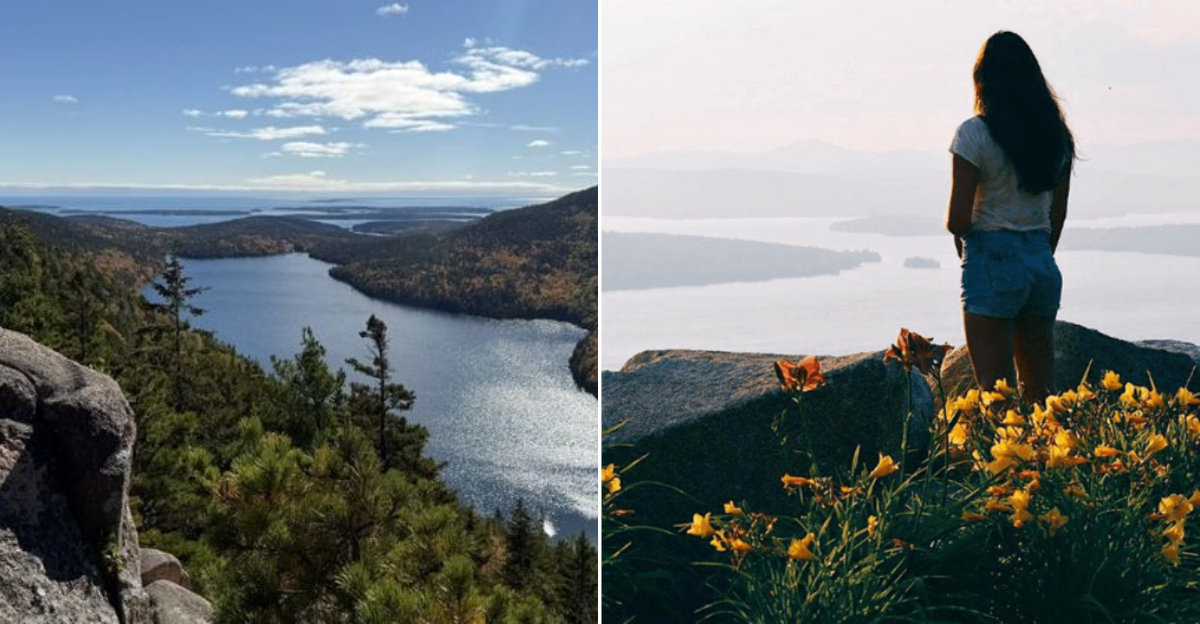
Mooselookmeguntic Lake From The Ridge
Locals shorten the name to “Mooselook,” maybe because saying it in full would waste time better spent staring at it. The lake spreads wide and calm, framed by ridges that catch every shift of light.
From this ridge you see the entire expanse, one of Maine’s largest freshwater bodies, shaped like an outstretched hand holding islands in its palm. The color changes hourly, steel to turquoise to glass.
Tip: bring binoculars. Watching boats crawl across that distance feels like glimpsing a slower world still running on patience.
Toothaker Island Centered In The Basin
At first glance it’s just a dark-green smudge in the middle of all that blue. Then the scale clicks, Toothaker Island is huge, forested, almost self-contained. The contrast feels cinematic.
Anchored squarely in Mooselookmeguntic Lake, the island breaks the horizon perfectly, its shape giving balance to the scene. The preserve protecting it keeps the wilderness unspoiled.
I liked how it made the lake feel both wild and composed, as if nature knew exactly where to place its punctuation mark.
Richardson Lakes Glinting To The West
Late light hits the western water like coins tossed in slow motion, flashes of gold skipping toward the horizon. The mood shifts from grand to gentle in an instant.
These are the Richardson Lakes, twin bodies just west of Mooselookmeguntic and part of the same watershed that feeds Maine’s wild interior. From the ridge, their surfaces seem endless, broken only by tree-tipped peninsulas.
I found myself tracing their outline with my eyes the way you’d follow handwriting, trying to memorize something you know you can’t keep.
White Mountains Faint On The Horizon
On a clear day, you can spot the White Mountains rising faintly like watercolor shadows against the edge of the sky. They feel distant yet familiar, a quiet echo of another range.
From this Maine overlook, the southern horizon opens just enough to reveal New Hampshire’s peaks, proof that beauty doesn’t care about borders. The view works best in dry, crisp air.
Tip: bring a light jacket even in summer. The wind that clears the haze also reminds you who’s in charge up here.
Paved Parking With Easy Walk-Up
Convenience doesn’t usually come this scenic. Park the car, take a dozen steps, and the view hits you full in the chest. The whole setup feels almost unfair.
The Height of Land overlook offers paved parking, safe railings, and level ground, making it one of Maine’s most accessible high-elevation viewpoints. You can visit in sneakers, coffee still in hand.
It’s the kind of place that erases excuses, no hike, no ticket, no schedule. Just a front-row seat to something undeniably vast.
Sunrise Glow Over The Lake Arms
At dawn the whole ridge feels hushed, like the air’s holding its breath. Then light spills over the lake’s branching arms, painting everything in rose and gold. The mood tips instantly from stillness to awe.
The overlook faces east, giving an unobstructed line to the first flare of sun as it rises over Mooselookmeguntic’s inlets. Clouds catch it first, then the water answers in ripples of color.
I’d seen photos, but nothing matched that quiet transformation, the lake waking up before the rest of us.
Sunset Color On Distant Summits
Here’s the trick: stay later than everyone else. When the crowd thins, the real show begins. The mountains far off turn mauve, then ember, then gray. It’s slow magic.
This ridge sits high enough to catch western light as it slides across the Richardson Lakes and lands softly on the White Mountains beyond. Each contour sharpens in the final minutes before dark.
Bring a blanket or tripod. Either way, you’ll want to linger long after the last photo feels necessary.
Summer Wildflowers In The Verge
A blur of color edges the pavement, lupine, black-eyed Susan, fireweed, all leaning toward the sun like a crowd cheering for July. The air smells faintly of pine resin and warm stone.
The Height of Land overlook becomes unexpectedly botanical in summer, with blooms thriving along the guardrails and hillsides. They turn the already grand view into a layered one.
There’s something about the wildflowers that humanizes the landscape. Amid the sweeping grandeur, these small flashes of color remind you: beauty can be loud or quiet, sometimes both.
Autumn Foliage Across The Byway
Some places wear fall like a costume; this ridge simply becomes it. Every slope bursts into flame, crimson maples, orange birch, golden aspen, and the air tastes faintly of woodsmoke.
The Rangeley Lakes Byway is legendary for October color, and the Height of Land marks its crown jewel. Hillsides roll like painted waves, each gust sending another handful of leaves airborne.
I’ve driven through plenty of fall displays, but this one feels immersive. It’s not scenery, it’s participation. You don’t watch autumn here; you stand inside it.
Informational Panels At The Rail
The railing does more than frame the view, it teaches it. Bronze panels line the edge, marking peaks, islands, and even the glacial story that shaped the basin. The design feels both elegant and generous.
Installed by the Rangeley Lakes Heritage Trust, these panels map out the region’s geography and history so visitors can decode what their eyes already love.
Linger with them before snapping photos. Understanding the layers, the ice, the fault lines, the people, turns the panorama into a living textbook.
Quick Stop For Tripod And Pano Shots
Photographers treat this spot like a pilgrimage. You’ll see them balancing tripods between car doors, chasing light like cats after reflections. The energy is almost contagious.
The overlook’s broad pullout makes it easy to set up panoramic gear or wide-angle shots. Early morning and dusk deliver the best contrast across Mooselookmeguntic’s arms and islands.
Even if you’re not a photographer, give it a try. The view practically composes itself, and you’ll leave with proof that Maine’s drama doesn’t need filters.
Mirror Lake And Lake Marie Downroad
Just a few bends beyond the main overlook, the world shrinks from grand panorama to intimacy. The air cools, and the lakes, Mirror and Marie, sit tucked among pines, their surfaces still as glass.
Both are part of the same glacial chain that feeds Mooselookmeguntic, smaller but no less stunning. Pull-offs along Route 17 make them easy to visit after the main ridge.
It’s funny, after the drama up top, these two feel like a whisper. They’re the encore nobody expects but everyone remembers.
Medicine Bow Peak, Viewpoint Toward High Country
A glint on the far horizon catches the eye, peaks etched faintly against the sky like pencil marks on watercolor paper. The scale takes a moment to register.
From the Height of Land ridge, clear days open sightlines toward the higher country beyond Rangeley, including the Medicine Bow area and distant western ridges. The air feels thinner, sharper.
Bring a telephoto lens if you have one. Once you spot those outlines, you’ll want proof you weren’t just imagining them.
Rangeley Lakes Byway Mileposts Nearby
Every few miles, a tiny green sign appears, Rangeley Lakes Byway, another mile ticked, another scene unlocked. The rhythm of travel here feels meditative.
Stretching roughly 35 miles across Routes 4 and 17, the byway links lakes, trailheads, and overlooks, each framed by forest and water. It’s one of Maine’s designated National Scenic Byways.
The best part isn’t the driving but the pausing. Each stop feels like an invitation to breathe differently, to let the silence settle somewhere behind your ribs.
Shoulder Season Calm On Clear Days
Late spring and early fall give this ridge a rare hush. No summer crowds, no bus engines, just the low hum of wind through fir branches. The silence feels earned.
The Height of Land overlook keeps its drama even on quiet days. Clear skies sharpen every line, from the mirror surface of Mooselookmeguntic to the faint ridges miles away. Locals say this is when the view feels most personal.
Those shoulder weeks are the sweet spot: still bright, perfectly crisp, and somehow just yours.