Why This 120-Mile Arizona Drive Deserves A Spot On Your Bucket List
Before it was officially numbered US-191, locals referred to this perilous mountain pass as “The Devil’s Highway.” Picture 120 miles of sheer drop-offs, hairpin turns, and zero guardrails where the pavement kisses the sky.
This is not the leisurely, flat desert cruise Arizona is famous for; this is a white-knuckle test of driving skill, a symphony of shifting gears, and a battle against vertigo. If your idea of a perfect road trip involves pushing limits and receiving a staggering visual payoff then strap in.
The Coronado Trail is waiting to prove whether you’re a tourist or a true adventurer.
Devil’s Highway To Dreamview: A Road With Serious Character
Gripping the wheel through that first set of hairpins feels like threading a needle while riding a roller coaster.
Once numbered U.S. 666, the road earned its devilish nickname before being renumbered to U.S. 191 and officially designated the Coronado Trail Scenic Byway, tracing part of Spanish explorer Francisco Vázquez de Coronado’s 1540 route through the Southwest. Every curve demands respect, every vista demands a camera, and every mile reminds you why bucket lists were invented.
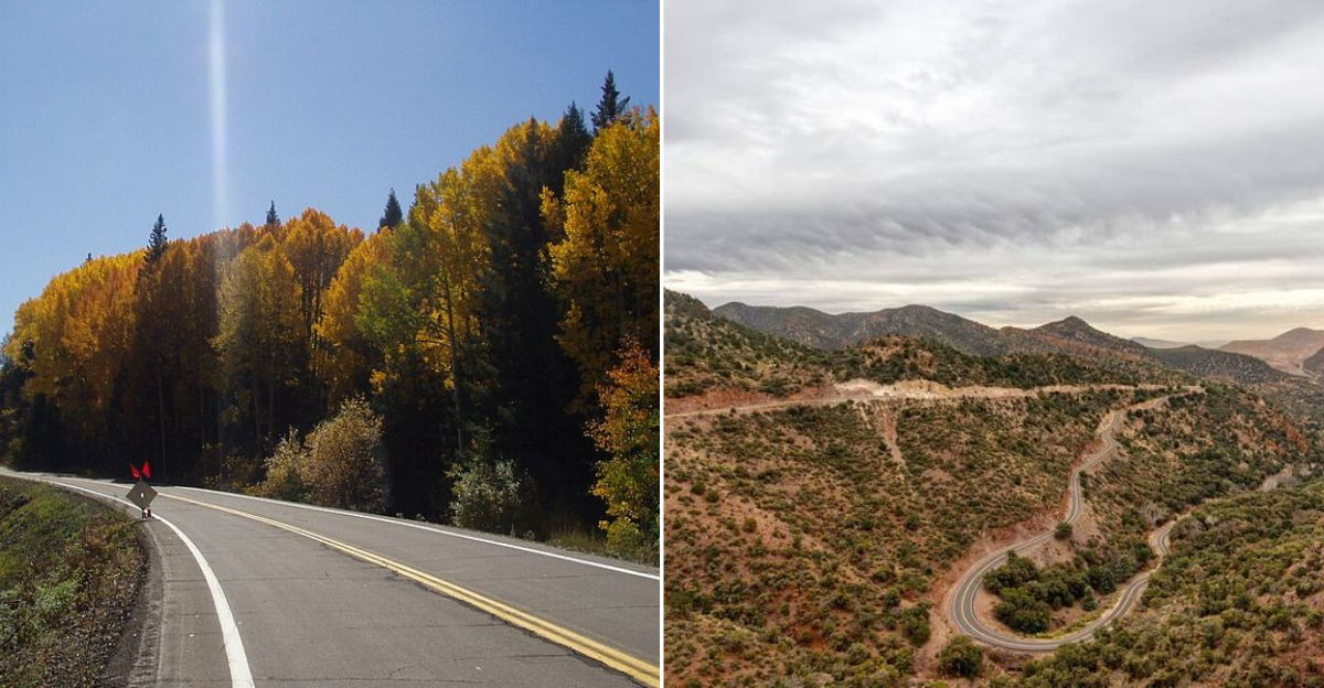
The switchbacks stack up like pearls on a string, dropping into canyons so deep they make your stomach flip. This isn’t just a drive. It’s a conversation between you, your vehicle, and gravity, with the Arizona wilderness eavesdropping on every word.
Switchbacks And Shivers: The Road That Refuses To Be Boring
Motorcyclists worship this asphalt ribbon, and sports car enthusiasts make pilgrimages here for good reason. Over 460 curves twist through the byway, with hairpin turns so tight you’ll swear the road designers were playing a prank on future drivers.
Steep grades and narrow shoulders hug sudden cliffs where guardrails take vacations, making every mile an exercise in focus and finesse. Speed control isn’t optional here; it’s survival.
Nervous drivers might want to hand over the keys, but thrill-seekers will find themselves grinning like kids on a carnival ride. The steering wheel becomes an extension of your hands, and the road becomes a dance partner who never steps on your toes.
The Scenery Changes Fast
Alpine meadows carpeted with wildflowers give way to rocky rim country, which then tumbles into deep canyons and desert scrub as elevation drops. The Mogollon Rim creates these dramatic ecosystem shifts, turning a single drive into a geography lesson you’ll actually remember.
Summer brings elk grazing in high country meadows and wildflowers painting the landscape in purples and yellows. Winter transforms the upper elevations into snow-dusted wonderlands, though some sections can close when weather gets feisty.
One minute you’re breathing pine-scented mountain air, the next you’re staring at the massive Morenci copper mine carving geometric patterns into canyon walls. Nature wrote this script with a flair for drama.
Stops That Make The Drive
Springerville and Eagar anchor the northern end, where the Madonna of the Trail monument stands guard over travelers. Hannagan Meadow offers a rustic lodge where guides swap stories over morning coffee, and Alpine provides a welcome breather mid-journey.
Clifton and Morenci at the southern terminus showcase mining history through a historic train depot and jaw-dropping views of the open-pit mine. Local diners serve coffee strong enough to keep you alert through the next fifty curves.
Budget one long day if you’re all business, or stretch it to two days for hiking, fishing, and actually tasting that diner pie. The road doesn’t judge your pace.
Fuel, Food, And When To Turn Around
Romance meets reality when your fuel gauge drops and the next gas station is forty miles away. Services are sparse along this 120-mile byway, so fill your tank before starting, pack water and snacks, and check weather reports like your trip depends on it because it does.
Cell signals vanish for long stretches, and wildlife like elk and deer treat the road like their personal crosswalk. Narrow sections lack guardrails, and seasonal closures or icy patches can turn adventure into misadventure fast.
Pack a full tank, spare water, warm layers, your camera, and a good map or offline navigation. This isn’t the place to wing it or trust your phone’s last bar of service.
Sound, Smells, And Tiny Wonders
Cooling brakes pop and tick after a long descent, creating a symphony nobody puts on playlists but everyone remembers. Pine and sage perfume the dawn air, while wet earth after a summer storm smells like the planet taking a deep breath.
High meadow silence wraps around you like a blanket, broken only by wind through aspens or a distant elk bugle. Tiny pullouts reveal cliffside wildflowers clinging to rock faces, small waterfalls trickling down mossy stone, and old mine overlooks telling stories without words.
I once stopped at a nameless turnout where a hawk circled so close I could count its wing feathers. These micro-moments make the miles matter more than any guidebook ever could.
History Wrapped In Asphalt: Following Coronado’s Ghost
Francisco Vázquez de Coronado marched through this region in 1540, chasing rumors of golden cities that turned out to be mirages wrapped in legend. While he never found Cibola’s mythical riches, his route became the foundation for this modern byway that rewards travelers with treasures of a different kind.
The road traces his path through terrain that hasn’t softened much in nearly five centuries. Historical markers dot the route, whispering stories of Spanish conquistadors, Apache warriors, and copper miners who all left their fingerprints on these mountains.
Driving where Coronado walked adds weight to every turn. The golden cities were fiction, but the golden light hitting these canyons at sunset is absolutely real.