This Hidden Canyon In Utah Is So Majestic, You’ll Feel Like You Found A Lost World
Tucked away in southern Utah’s backcountry, Coyote Gulch is one of those places that makes you question whether you accidentally walked through a portal into another dimension.
I first heard about this canyon from a ranger who described it as the kind of spot that stops people mid-stride and leaves them staring upward with their mouths hanging open.
Towering sandstone arches, hidden waterfalls, and a creek that winds through walls glowing orange and gold create a landscape so surreal it feels like nature’s own theme park.
If you’re ready to trade crowds and cell service for something truly wild, this hidden canyon delivers an adventure you won’t forget.
The Canyon That Feels Like You Slipped Off The Map
Sun-baked slickrock breaks open into a cool corridor of orange walls, cottonwoods, and flowing water.
Coyote Gulch sits in a remote corner of southern Utah, where a small desert stream has carved a twisting sandstone canyon that feels separate from the rest of the world.
Hikers drop in from a dry, harsh plateau and suddenly step into shade, running water, and echoes that bounce like you walked onto a movie set.
The contrast between the barren approach and the lush canyon floor is jarring in the best possible way.
Everything about this place whispers isolation and discovery, as if you’re the first person to stumble upon it.
Where This Lost World Actually Lives
Coyote Gulch is a tributary of the Escalante River in southern Utah, mostly inside Grand Staircase–Escalante National Monument, with its lower reaches crossing into Glen Canyon National Recreation Area.
Access usually starts off Hole-in-the-Rock Road near the town of Escalante, with popular entry points at Hurricane Wash, Red Well, and the Fortymile Ridge trailheads.
Distances can run roughly twelve to fourteen miles one way, depending on the route, which helps keep the canyon feeling remote.
Getting there usually means driving a long, graded dirt road where high-clearance is often recommended, and a bit of map-reading confidence.
The remoteness is part of the charm, keeping visitor numbers manageable.
Dropping From Desert Heat Into A Living Oasis
Hikers begin in a sandy wash under full sun, following a faint path and wondering what the hype is about. Gradually, the wash deepens, walls rise, and a small stream appears at your feet.
Soon you are walking ankle-deep in clear water over soft sand, surrounded by curving red rock, hanging gardens, and birdsong that drowns out any memory of traffic or city noise.
The transformation from harsh desert to riparian paradise happens so quickly that it feels like a magic trick.
I remember the first time I felt that cool water on my boots and thought I’d stepped into a different climate zone altogether.
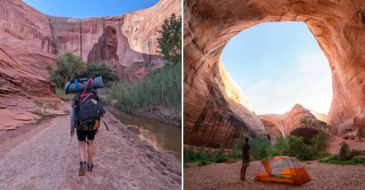
Jacob Hamblin Arch, The Canyon’s Giant Stone Gateway
Far inside the gulch, the sandstone suddenly opens into an enormous alcove pierced by Jacob Hamblin Arch, a huge sweep of rock that frames sky, trees, and the flowing creek.
Standing beneath it feels like walking into a natural cathedral, with light glowing off the walls in gold and rose tones.
Many visitors treat this spot as the emotional heart of the trip and basecamp nearby on sandy benches beneath the overhang. The scale of the arch is hard to grasp until you see a person standing beneath it.
Photographers chase the light here at sunrise and sunset for good reason.
Natural Bridges, Waterfalls, And The Escalante Confluence
Downstream from Jacob Hamblin Arch, the canyon stays dramatic, with Coyote Natural Bridge spanning the creek and smaller waterfalls sliding over smooth rock shelves.
Strong parties may continue all the way to the Escalante River, where the canyon meets a larger corridor and hikers can look up toward the towering span of Stevens Arch.
Each landmark adds another layer to that lost world feeling, like different levels in an open-world game. The deeper you go, the more the landscape rewards your effort.
Turning around at the confluence feels like leaving a secret you want to keep to yourself.
When To Go So The Magic Hits Just Right
Spring and fall usually offer the best balance of cooler temperatures and flowing water, while summer heat on the approach can be intense, and winter can bring cold, ice, or high water.
Flash-flood risk is real in canyon country, so hikers watch the forecast carefully and avoid trips when storms threaten the wider Escalante basin.
Many visitors plan two to three days, so the place can be savored slowly instead of rushed like a speedrun. Timing your trip right means the difference between a magical experience and a survival ordeal.
I learned that lesson the hard way during a July hike that felt like hiking inside an oven.
Permits, Safety, And Treating The Canyon With Respect
Overnight trips in the Escalante District require a free backcountry permit, obtained either at the Escalante Interagency Visitor Center or at self-serve stations at key trailheads.
Regulations ask hikers to camp on durable surfaces, pack out all waste, and avoid trampling delicate vegetation along the stream.
Preparation matters here: routes vary in difficulty, entry and exit points can involve steep slickrock or scrambling, and water levels, rockfall, or changing conditions can alter the experience from year to year.
Knowing what you’re getting into keeps both you and the canyon safer.
Packing Smart For A Multi-Day Canyon Adventure
Water management is critical since the creek flows year-round but needs filtering or treatment before drinking. Pack a reliable filter, extra capacity for dry stretches, and enough food for your planned days, plus a safety margin.
Footwear that can handle wet conditions is essential since you’ll be walking through the creek repeatedly, and quick-dry clothing helps you stay comfortable.
Navigation tools like a GPS device or a detailed map are smart backups since trails can be faint or nonexistent.
I once forgot extra socks and spent two days with pruney feet, which taught me a lesson I’ll never forget.
The Geology That Built This Hidden Masterpiece
Coyote Gulch carves through Navajo Sandstone, a formation laid down as ancient sand dunes roughly 180 million years ago during the Jurassic Period.
Wind and water sculpted those dunes into stone, and then millions of years of erosion by the creek carved the twisting canyon we see today.
The result is a landscape of smooth, flowing curves, alcoves, and arches that look almost intentionally designed.
Cross-bedding patterns in the rock walls reveal the direction ancient winds blew, frozen in stone like a snapshot of deep time.
Understanding the geology makes every curve and arch feel even more remarkable.
Wildlife And Plant Life In The Canyon Corridor
Cottonwoods and willows line the creek, providing shade and habitat for birds like canyon wrens, great blue herons, and the occasional peregrine falcon.
Hanging gardens cling to seeps in the rock, with maidenhair ferns, columbines, and mosses creating pockets of green against the red stone.
Lizards sun themselves on warm rock, and tracks in the sand hint at visits from deer, coyotes, and ringtail cats.
The contrast between the dry plateau above and the riparian zone below creates a biodiversity hotspot in the middle of the desert.
Watching a heron take flight between canyon walls is a moment that stays with you.
Camping Beneath The Stars In A Sandstone Sanctuary
Campsites on sandy benches beneath arches or beside the creek offer front-row seats to one of the darkest night skies in the lower 48 states.
The Milky Way stretches overhead in a band so bright it casts shadows, and the only sounds are the creek’s murmur and the occasional rustle of cottonwood leaves.
Waking up to sunlight creeping down the canyon walls and hitting the water in golden shafts is worth every mile of the hike in. The isolation and beauty combine to create a camping experience that feels almost spiritual.
I’ve never slept better than I did on a sandy bench under Jacob Hamblin Arch.