11 Deserted Ghost Towns In Tennessee That History Lovers Still Wander Through
Tennessee hides dozens of abandoned communities in its mountains, valleys, and beneath its lakes. Some vanished when dams flooded entire valleys, others emptied as logging camps shut down or the government seized land for secret projects.
Walking through these ghost towns today feels like stepping into a time capsule, where crumbling cabins, old cemeteries, and overgrown roads tell stories of families, industries, and dreams that once filled these quiet places.
History lovers trek deep into national parks, paddle across reservoirs, and follow forgotten trails to find these lost settlements and imagine the voices that once echoed through their streets.
1. Elkmont Ghost Town, Great Smoky Mountains National Park
Following the Little River upstream from Gatlinburg, the pavement narrows and the forest suddenly opens onto an entire abandoned neighborhood.
Weathered vacation cabins line the old main road at Elkmont, their porches sagging and screen doors hanging crooked, as if the owners just never came back from summer break.
Elkmont began as a logging camp in the early 1900s, then turned into a private mountain resort for Knoxville elites who built dozens of rustic cottages up this cool, shaded valley.
When Great Smoky Mountains National Park was created in the 1930s, families accepted leases instead of immediate eviction, but those leases eventually expired and the cottages were left to the elements.
Today the National Park Service has restored a handful of buildings along Daisy Town and stabilized others.
You can freely walk the quiet loop road, peer through wavy glass into old parlors, and imagine dance music drifting through the trees.
2. No Business, Big South Fork National River and Recreation Area
Reaching No Business is not a quick roadside stop but a full day of stepping into the past.
Deep inside the Big South Fork National River and Recreation Area in northern Tennessee, the old No Business community once stretched along a narrow creek valley, a string of farms, a school, church, and stores that rarely saw outsiders.
Founded in the late 1700s and home to roughly three hundred people at its height, No Business slowly emptied out as logging and coal jobs vanished and younger generations left after World War II. The last resident moved away in 1960.
Nowadays, hikers follow the No Business Trail and faint old roads to find low stone foundations, fence posts swallowed by trees, and family cemeteries tucked into the hills.
Even the modern No Business 100 ultra race loops past the old settlement, proof that the name still lingers on maps and in trail stories.
3. Old Jefferson, On The Shore Of Percy Priest Lake
On the edge of Percy Priest Lake near Murfreesboro, there is a stretch of woods where the map still whispers a name that the water never quite claimed.
This was Old Jefferson, the original seat of Rutherford County and a bustling river town long before Murfreesboro grew up the road.
In the 1960s, the Army Corps of Engineers bought out the town to make room for the new Percy Priest Dam, and buildings were cleared with the expectation that the lake would rise and drown what was left.
The waterline stopped short, leaving streets, foundations, and old yards as empty clearings hidden behind the Jefferson Springs Recreation Area.
Today, history buffs and former residents lead occasional walks through the ruins, pointing out where the courthouse stood and where the main street ran, while fishermen launch their boats only a few yards away.
4. Wheat, The Town Swallowed By Oak Ridge
Driving the back roads west of Oak Ridge, you pass a lonely white church and a cemetery on a rise above the river.
It looks like an ordinary country church, but this is almost all that remains of Wheat, a farming community that vanished when the United States government seized the valley to build the secret city of Oak Ridge during World War II.
Before the Manhattan Project, Wheat had homes, schools, stores, and fertile farmland spread along the Clinch River.
In 1942, residents were given notice and the town was essentially erased from the map, its land absorbed into a high-security nuclear reservation.
These days, visitors can still reach George Jones Memorial Baptist Church and adjacent graveyards along modern Wheat Road and nearby greenways, where interpretive signs explain how this quiet hillside once looked over a living town.
5. Tharpe, Lost Inside Land Between The Lakes
Between the Tennessee and Cumberland rivers, in the wooded strip now called Land Between the Lakes, the ghost of Tharpe is scattered among pines and overgrown clearings.
Once known as Iron Mountain, this community grew up around an iron furnace in the 1850s and later supported mills, a blacksmith shop, tobacco operations, a doctor’s office, school, churches, and a general store serving several hundred people in northern Stewart County.
The Great Depression thinned the population, and in the late 1960s, the Tennessee Valley Authority acquired the land so that this entire peninsula could become a large recreation area.
Houses were removed, businesses closed, and Tharpe quietly disappeared into the new federal landscape.
Now, travelers drive the Woodlands Trace scenic byway straight through what used to be the town center, and curious visitors can walk side roads to find scattered bricks and old home sites.
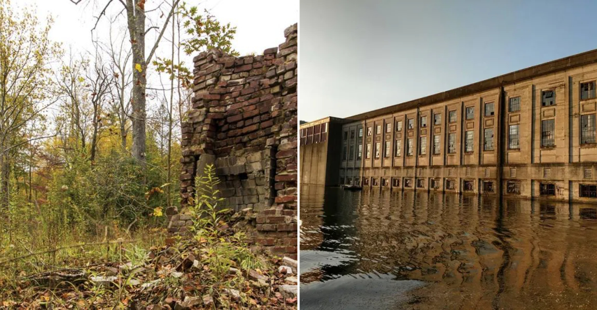
6. Hales Bar Dam And The Vanished Workers’ Town, Haletown And Guild
Southwest of Chattanooga, the Tennessee River widens into Nickajack Lake, and on its shore the hulking powerhouse of Hales Bar Dam sits like a haunted castle of concrete.
In the early 1900s, this pioneering hydroelectric project created two busy company towns, Guild and Haletown, to house the thousands of workers who built and operated the dam, complete with schools, churches, stores, and a post office.
When the Tennessee Valley Authority replaced leaky Hales Bar with Nickajack Dam in the 1960s, much of the old worker community declined and dispersed.
The powerhouse survived and today hosts guided history and ghost tours, events, and a marina, turning what was once an industrial site into a strange hybrid of ruin and attraction.
Visitors walk through echoing turbine halls and dark tunnels, learning how the dam shaped and then outlived the town that grew up around it.
7. Loyston, The Town Beneath Norris Lake
At first, Norris Lake looks like any other mountain reservoir, blue water curling into coves beneath forested ridges.
What most swimmers and kayakers do not realize is that one of Tennessee’s best documented ghost towns lies on the bottom: Loyston, a small trading center that once had a mill, two stores, two churches, a post office, and schools that served the surrounding farms.
When Norris Dam went up in the 1930s, TVA relocated Loyston’s families and flooded the valley, creating a broad reach of water now known as Loyston Sea.
Today, you can hike to Loyston Overlook in Big Ridge State Park and gaze down at the drowned town site, or boat across the calm expanse that covers its streets.
Interpretive materials from the Tennessee State Museum and local historians keep the story alive, so that even though you cannot walk the old roads, you can stand above them.
8. Willow Grove, The Town That Drowned In Dale Hollow Lake
On the far northern edge of Tennessee, Dale Hollow Lake hides another ghost beneath its clear green water.
Willow Grove was once Clay County’s second-largest town, a prosperous farming community with a school, churches, businesses, and the best bottomland in the area.
All of that vanished in the early 1940s when the U.S. Army Corps of Engineers bought out the valley and built Dale Hollow Dam, flooding the Obey River and Iron Creek.
Locals call it the town that drowned, and in rare drought years, the foundation of the old school can still be seen on the lake bottom in aerial photos.
The land that did not submerge became part of the surrounding wildlife management area, and modern visitors reach the old community by driving Tennessee Route 294 to Willow Grove Marina and Resort.
For history lovers, the story is written in displays, reunions of former residents, and in the unsettling knowledge that an entire town lies just out of sight under the waves.
9. Old Butler, Under Watauga Lake And Remembered In A Museum
In the hills of Johnson County, Watauga Lake sparkles where the town of Butler once stood.
Founded in the eighteenth century and later a busy valley community with schools, stores, and more than a hundred homes, Butler suffered repeated floods before TVA finally decided to relocate the town in the 1940s and create a reservoir that would drown the original site.
Today, Old Butler rests on the lake bottom, but its story is very much alive.
New Butler was rebuilt on higher ground along Tennessee Route 67, and residents saved everything from a horse-drawn hearse to post office fixtures, which are now displayed at the Butler Museum in the present-day town.
Visitors can tour the museum, attend Old Butler Days festivals, and then drive up to lakeside overlooks and imagine streets and church steeples far below the peaceful surface.
10. Rhea Springs, The Spa Town Lost To Watts Bar Lake
Long before Watts Bar Dam tamed the Tennessee River, Rhea Springs was a fashionable nineteenth-century health resort, built around a sulfur spring along the Piney River.
Travelers came from cities like Atlanta, New Orleans, and Memphis to stay in its large hotel, drink the mineral water, and stroll past homes, churches, and an academy on the edge of the valley.
When TVA completed Watts Bar Dam in the early 1940s, the lower Piney Valley flooded and Rhea Springs disappeared beneath the new lake.
Nowadays, campers and paddlers use the Rhea Springs Recreation Area near Spring City as a lakeside getaway, often unaware that they are pitching tents almost exactly where spa guests once disembarked from riverboats.
A memorial in nearby parks and local histories keep Rhea Springs’ name alive, and if you sit by the water at sunset, it is easy to imagine the grand hotel rising again out of the mist.
11. Copper Hill Mining District, Ducktown Basin
Copper Hill and its neighbouring communities, Ducktown and Isabella, look less like typical Tennessee ghost towns and more like the surface of Mars.
Massive copper mining operations starting in the 1850s stripped the surrounding mountains of every tree and plant, leaving behind a surreal red and orange wasteland that stretched for miles.
Open-pit smelting released sulfuric acid fumes that poisoned the soil, creating one of the most extreme environmental scars in the eastern United States.
Mining peaked in the early twentieth century, employing thousands, but by the 1980s, the last mines closed and the workforce scattered.
Today, the Ducktown Basin Museum preserves the industrial history, and reclamation efforts have slowly brought back patches of green.
Visitors can tour old mining sites, see the lunar landscape from overlooks, and walk through what remains of the once-booming company towns that rose and fell with the copper market.