10 Scenic Drives In Utah That Will Blow You Away
Utah isn’t just a state, it’s basically nature showing off with red rocks, twisty canyons, and mountains that look like they were painted by an artist who had way too much coffee.
When you hit the road here, you’re not just driving to get somewhere; you’re on a journey through landscapes so stunning they’ll make you pull over every five minutes for photos.
From winding byways that slice through ancient rock formations to park roads that feel like they belong in a movie, these drives will leave you speechless (and probably with a very full camera roll).
Buckle up, because we’re about to explore ten roads that prove Utah is the ultimate road trip destination!
1. Scenic Byway 12 – A Journey Through Time
Picture this: you’re cruising along a ribbon of asphalt that twists through some of the most jaw-dropping terrain on planet Earth, and every single curve reveals something more spectacular than the last.
Scenic Byway 12 stretches for about 123 miles between Panguitch and Torrey, and honestly, calling it just a “road” feels like calling the Grand Canyon just a “ditch.”
Starting near Red Canyon with its flaming orange hoodoos that look like nature’s own sculpture garden, the route climbs over Boulder Mountain where you’ll find yourself surrounded by forests so thick and green they seem impossible in the desert.
The section near Escalante is where things get really wild—you’ll drive along knife-edge ridges called the Hogback, where the road is barely wider than your car and drops off dramatically on both sides.
Capitol Reef National Park marks the eastern terminus, but the real magic happens in between, where you’ll pass through tiny towns like Boulder, which was historically one of the last places in the lower 48 states to receive regular mail service by mule.
Pack snacks, charge your camera, and give yourself way more time than GPS suggests because you’ll want to stop at every single overlook.
This isn’t just a drive—it’s basically a masterclass in why Utah is the coolest geology classroom you’ll ever attend!
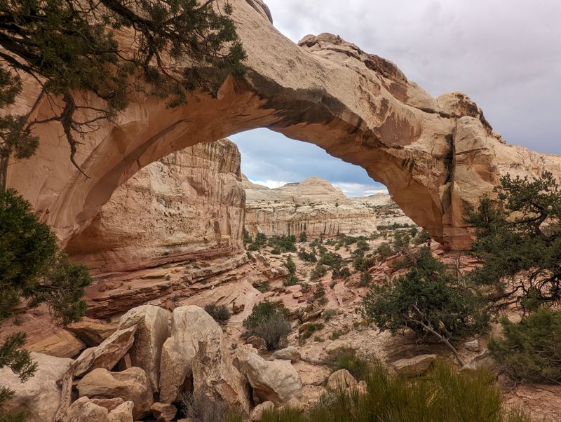
2. Capitol Reef Country Scenic Byway
Ever wanted to feel like you’re driving through a rainbow made of stone?
Capitol Reef Country Scenic Byway (UT-24) follows the Fremont River corridor from the town of Loa to Hanksville, passing along and through the heart of Capitol Reef National Park.
The Fremont River keeps you company for much of the journey, its green cottonwood trees creating a gorgeous contrast against the rust-red and cream-colored cliffs that tower overhead like ancient skyscrapers.
Capitol Reef itself got its name because early settlers thought the white Navajo Sandstone domes looked like the U.S. Capitol building, and the rocky cliffs formed a “reef” that blocked their westward travel.
You’ll pass through the historic Fruita District, where pioneer orchards still produce cherries, apricots, and apples that you can pick yourself during harvest season (yes, really!).
Petroglyphs left by the ancient Fremont people decorate cliff walls near the road, telling stories from over a thousand years ago in pictures instead of words.
The Cathedral Valley area is worth exploring if you have a high-clearance vehicle and extra time, though access involves rough backcountry roads rather than a simple roadside detour.
This byway proves that sometimes the best adventures happen when you take the road less traveled through Utah’s hidden gem of a national park!
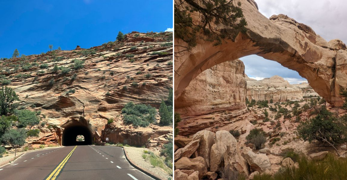
3. Zion-Mount Carmel Highway and Zion Tunnel
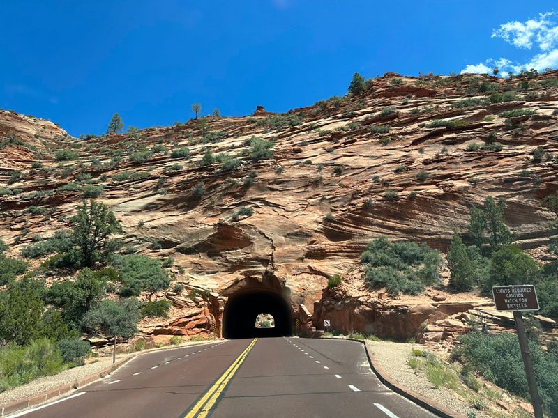
Hold onto your steering wheel because UT-9 through Zion National Park is about to take you on the most thrilling 12-mile journey of your life!
The Zion–Mount Carmel Highway spans roughly 12 miles between Zion Canyon and the park’s east entrance, and it does so with more drama than a season finale of your favorite show.
Built in 1930, this engineering marvel includes a series of switchbacks so tight and scenic that you’ll understand why larger vehicles need special permits and traffic control to navigate them.
But the real star of this show is the Zion-Mount Carmel Tunnel, a 1.1-mile bore carved straight through solid sandstone with “gallery windows” that offer quick peeks at the canyon below.
When you emerge on the east side, you’re suddenly in a completely different world of slickrock domes, petrified sand dunes, and formations with names like Checkerboard Mesa that looks exactly like its name suggests.
The contrast between the lush, river-carved canyon on the west side and the alien-looking slickrock landscape on the east is so dramatic it feels like driving through a portal.
Rangers recommend driving this route in both directions because the views are completely different depending on which way you’re headed.
Travelers should note that starting in 2026, vehicles over certain size limits will no longer be permitted to pass through the Zion–Mount Carmel Tunnel.
Seriously, this highway is proof that sometimes the journey really is more important than the destination—though Zion makes both pretty spectacular!
4. Upper Colorado River Scenic Byway
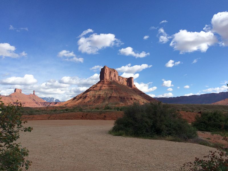
Imagine cruising along a road where a legendary river is your constant companion and red rock towers stand guard like ancient sentinels—that’s SR-128 in a nutshell.
Starting just north of Moab and running for 44 miles to I-70, this byway hugs the Colorado River so closely you could practically dip your toes in the water from your car window (please don’t actually try that).
The route showcases some of the most iconic rock formations in the American Southwest, including Fisher Towers, those impossibly tall and skinny spires that look like they’re defying gravity just to mess with you.
Castle Valley opens up about halfway through the drive, revealing the massive Castleton Tower and other formations that have made this area famous among rock climbers and photographers.
The Moab area has long attracted filmmakers, and portions of this corridor and nearby landscapes have appeared in movies, commercials, and photo shoots over the decades.
The river itself changes personality with the seasons—raging with snowmelt in spring, calm and perfect for rafting in summer, and reflective as a mirror in fall when the cottonwoods turn gold.
Pack a picnic because there are dozens of pullouts and informal camping spots where you can sit riverside and watch the world’s most beautiful scenery drift by.
This drive reminds you that sometimes the best therapy isn’t in an office—it’s on a winding road with a river soundtrack and million-dollar views!
5. Bicentennial Highway Scenic Byway
SR-95 runs for about 121 miles through some of the most remote and wildly beautiful country you’ll ever experience.
Designated in 1976 for America’s 200th birthday (hence the “Bicentennial” name), this highway connects Hanksville to Blanding while passing through landscapes that look like they haven’t changed since dinosaurs roamed here.
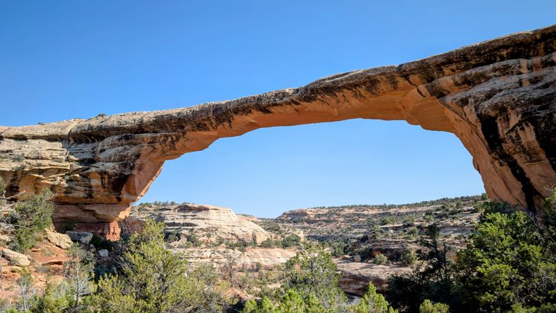
Natural Bridges National Monument is the crown jewel along this route, featuring three massive stone bridges carved by water over millions of years—Sipapu, Kachina, and Owachomo each have their own personality and story.
The drive descends into and climbs out of countless canyons, each one revealing different layers of geological history like pages in Earth’s autobiography.
You’ll cross the Dirty Devil River (yes, that’s its real name, and yes, there’s a story behind it involving a grumpy explorer) and skirt the edge of Glen Canyon National Recreation Area.
Cell service is basically non-existent out here, which is either terrifying or liberating depending on your perspective—probably both!
The section near Fry Canyon offers views that stretch for literally dozens of miles across uninhabited wilderness where the night sky puts on a show that makes city lights look pathetic.
Bring extra water, gas up beforehand, and prepare for an adventure that feels like traveling back to a time when roads were rare and nature ruled everything!
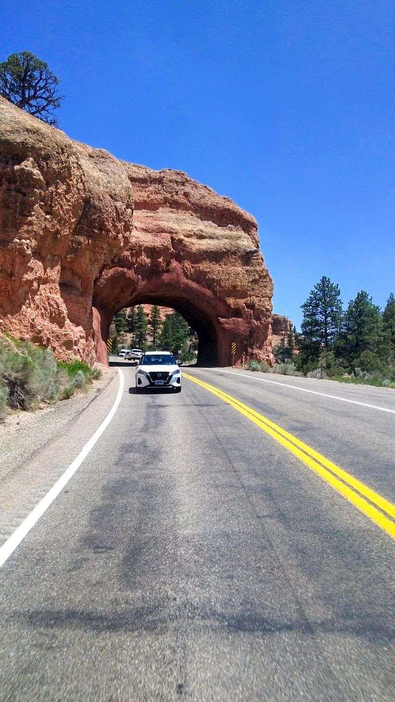
6. Cedar Canyon Scenic Byway

Who says Utah is all desert?
SR-14, also known as Cedar Canyon or Cedar Mountain Drive, climbs from Cedar City up through Cedar Canyon for 41 miles to Long Valley Junction, trading red rocks for pine forests so fast you’ll wonder if you accidentally drove to Colorado.
Starting at an elevation of about 5,800 feet in Cedar City, the road climbs to over 10,000 feet at Cedar Breaks National Monument, where the temperature can drop 20 degrees and the landscape transforms completely.
Cedar Breaks National Monument is reached via SR-148, a scenic spur that branches off SR-14 and climbs to elevations over 10,000 feet.
The route passes through thick forests of ponderosa pine, spruce, and fir, with meadows full of wildflowers in summer that would make any Instagram influencer weep with joy.
Several scenic overlooks provide drop-dead gorgeous views back toward the valley and out across the endless landscape of southern Utah.
In winter, this becomes a completely different animal—a snowy wonderland where the road leads to ski resorts and snowmobile trails instead of desert hikes.
The small mountain communities along the way, like Duck Creek Village, offer that cozy alpine vibe complete with cabins, lodges, and the kind of fresh air that makes you want to bottle it up and take it home.
This drive is perfect proof that Utah has serious range when it comes to landscapes!
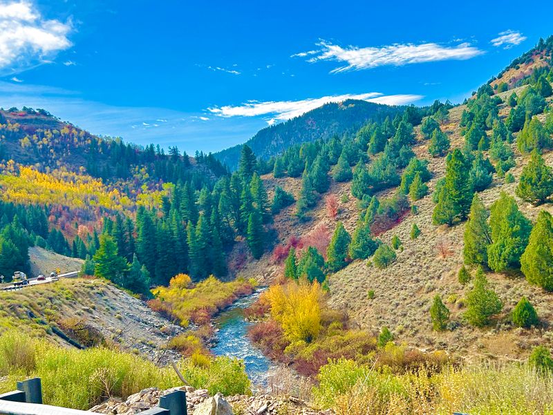
7. Logan Canyon National Scenic Byway
US-89 through Logan Canyon is where northern Utah flexes its scenic muscles with a 41-mile stretch that climbs from the college town of Logan up to Bear Lake, and it’s absolutely gorgeous year-round.
The Logan River accompanies you for much of the journey, tumbling over rocks and creating that perfect soundtrack of rushing water that makes everything feel more adventurous.
Towering limestone cliffs rise straight up on both sides of the canyon, their faces carved and sculpted by time into formations that rock climbers love and photographers can’t resist.
In fall, the canyon explodes with color as maples, oaks, and aspens turn every shade of red, orange, and gold you can imagine—it’s basically Utah’s version of New England foliage but with mountains that are way more dramatic.
Recreation opportunities are everywhere: hiking trails branch off to waterfalls and caves, fishing holes tempt anglers, and picnic areas are scattered along the route like nature’s rest stops.
After cresting the canyon, the road descends toward Bear Lake, that stunning turquoise body of water locals call the “Caribbean of the Rockies” because of its bizarre blue-green color (caused by limestone particles suspended in the water).
Winter transforms this drive into a snowy paradise with access to Beaver Mountain Ski Resort and miles of trails for snowmobiling and cross-country skiing.
Local tip: stop at one of the roadside stands for fresh raspberry shakes in summer—Bear Lake raspberries are famous for a reason, and that reason is they’re absolutely delicious!
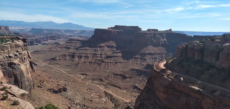
8. Canyonlands Island in the Sky Scenic Drive
Buckle up for a drive that literally puts you on top of the world—or at least on top of a massive mesa with thousand-foot drops on all sides!
The Island in the Sky district of Canyonlands National Park features a scenic drive that is about 12 miles one-way to Grand View Point, or roughly 34 miles round trip when visiting the major overlooks, and those miles are some of the most spectacular pavement in America.
You’re driving along a flat-topped mesa that sits 1,000 feet above the surrounding terrain, with views that extend for literally dozens of miles in every direction across canyons, spires, and rock formations that look completely unreal.
Mesa Arch is a must-stop along the way—a short walk leads to a perfect stone arch perched right on the cliff edge, framing views of the La Sal Mountains in the distance.
The Grand View Point overlook at the end of the road offers a panorama so vast and complex that your brain struggles to process it all: the Colorado and Green Rivers carving through the landscape far below, countless side canyons branching off in every direction, and rock layers representing hundreds of millions of years of Earth’s history.
Upheaval Dome is another fascinating stop—a mysterious crater-like formation that scientists still debate about (meteor impact or underground salt dome collapse? The jury’s still out!).
This drive feels like being on an aircraft carrier made of stone, floating above an ocean of canyons, and it’s absolutely unforgettable!
9. Arches National Park Main Auto-Touring Road

If Instagram had a hometown, it would probably be along the main road through Arches National Park—seriously, every single turn reveals another postcard-worthy view.
The approximately 36-mile round-trip scenic drive (including spur roads) takes you through the world’s largest concentration of natural stone arches, with over 2,000 of them scattered throughout the park like nature’s own art gallery.
Starting just north of Moab, the road immediately climbs up a series of switchbacks that offer increasingly awesome views back toward the Colorado River and the La Sal Mountains.
Park Avenue greets you first with its massive sandstone “skyscrapers” lining both sides of a canyon like buildings on a city street—except these buildings are millions of years old and way more impressive than anything humans have built.
The Windows Section features some of the park’s largest and most accessible arches, including North and South Window and Turret Arch, all visible from relatively short walks.
Delicate Arch, Utah’s most famous landmark (it’s even on the license plates!), requires a moderate hike to reach, but seeing it in person is worth every step—it stands alone on the edge of a slickrock bowl like a perfectly placed sculpture.
Devil’s Garden at the end of the road offers the longest hiking trails and more arches than you can count, including the impressive Landscape Arch, which is one of the longest natural arches in the world.
This drive is basically a greatest-hits album of geological awesomeness!
10. Snow Canyon State Park Scenic Drive
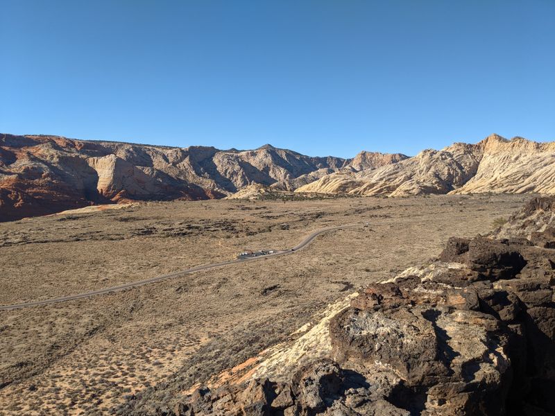
Don’t let the name fool you—Snow Canyon State Park (located near Ivins and St. George) is named after a pioneer family, not the white stuff that falls from the sky, and it’s actually a desert paradise perfect for exploring year-round.
A paved park road winds through Snow Canyon, showcasing a stunning landscape where red and white Navajo sandstone cliffs contrast dramatically with black lava rock flows that look like they cooled down just yesterday (spoiler: they’re actually thousands of years old).
This smaller, less-crowded cousin to Zion National Park offers similar jaw-dropping scenery without the massive crowds and shuttle buses—you can actually drive your own car through the entire park!
The red sand dunes in the northern section of the park are perfect for kids (and adults who are kids at heart) to climb and slide down while pretending they’re on Mars.
Hiking trails branch off from various pullouts along the drive, leading to slot canyons, ancient lava tubes, and overlooks with views that stretch clear to Arizona on clear days.
Wildlife is surprisingly abundant here—watch for desert tortoises, lizards doing push-ups on rocks, and birds of prey soaring on thermals above the canyon walls.
The park’s relatively low elevation (around 3,000 feet) makes it an ideal winter destination when Utah’s higher-elevation parks are buried in snow and ice.
This hidden gem proves that sometimes the best discoveries are the ones that don’t make every tourist’s must-see list—more beauty for those in the know!