10 Arkansas Hidden Spots Most Locals Don’t Even Know About (With Map)
Arkansas is full of places that don’t show up on the usual travel lists. Beyond the well-known parks and tourist stops, there are still trails and ancient mounds.
Historic homesteads and rushing waterfalls are also waiting to be found. Most people drive right past these spots without knowing what they’re missing.
This list is your guide to the real Arkansas. I’m talking about the kind that rewards curious travelers willing to look a little closer.
I focus on muffled corners where the air feels different and the silence is heavy. You won’t find these locations in a cheap tourist pamphlet.
My latest mission involved tracking down spots that even lifelong residents miss. These places offer a raw connection to the land.
I mapped out every single one to make your journey easier. Forget the crowded parks.
Each stop on this list has a story.
1. Haw Creek Falls Recreation Area
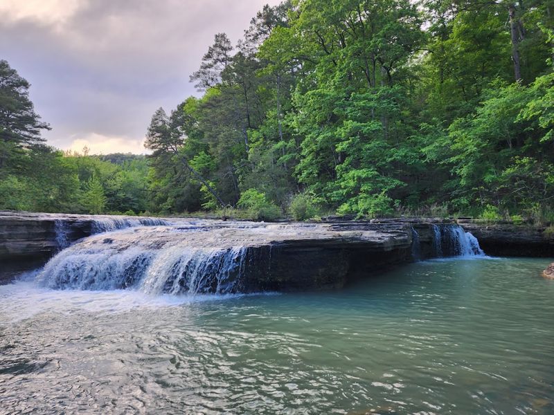
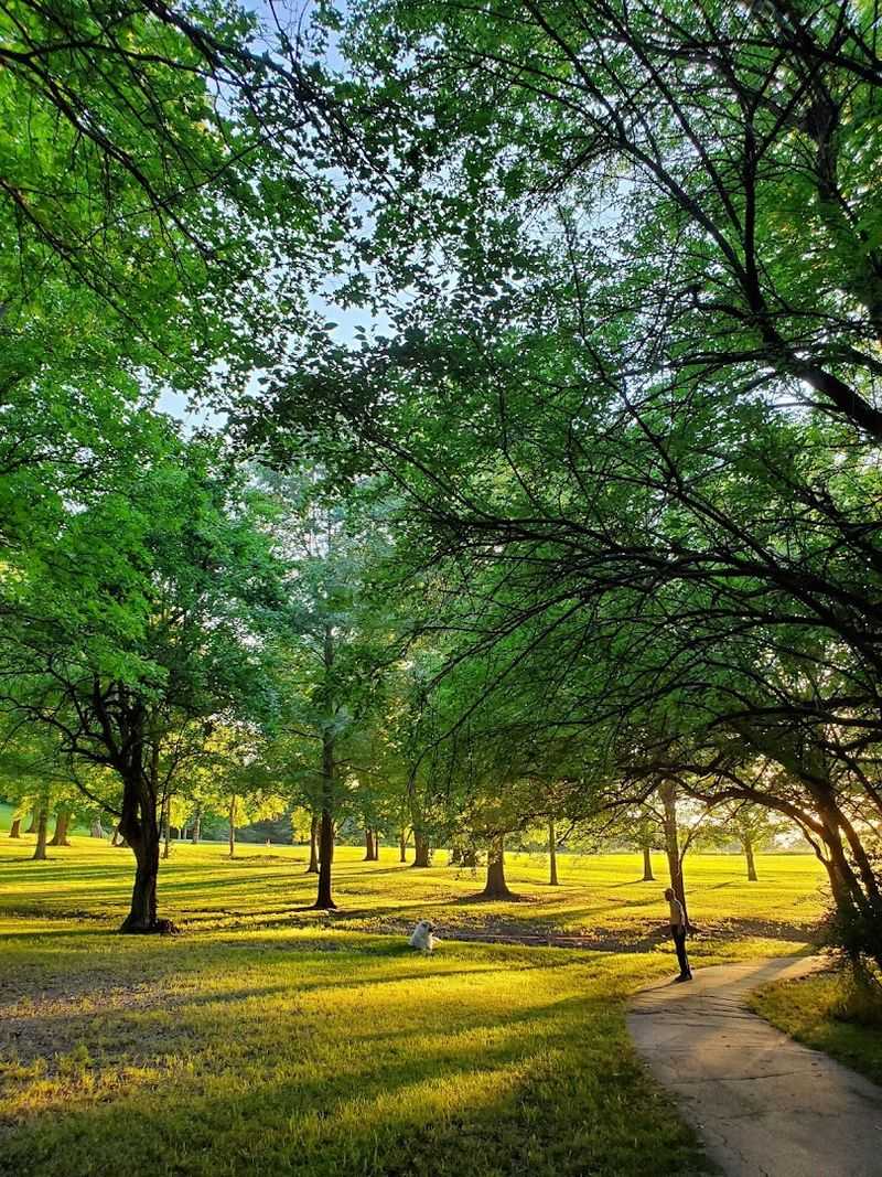
Not many people outside of Pope County have heard of Haw Creek Falls, and that is honestly their loss. This recreation area sits quietly along Hwy 123 in Hagarville.
It offers a combination of swimming, camping, and waterfall viewing that you would normally expect from a far more famous destination. The falls themselves are modest in height but wide enough to create a natural pool that is genuinely inviting on a hot afternoon.
I visited on a weekday in late summer and had the area almost entirely to myself. The creek runs cold and clear even in August, which made wading in feel like a reward after the short walk from the parking area.
The surrounding forest is thick and green, and the sound of moving water follows you the whole way in.
The campground nearby is simple but clean, with sites that sit close to the creek so you can fall asleep to the sound of running water. There are no hookups or fancy amenities, but the setting more than compensates.
Families with kids tend to love this spot because the shallow areas of the creek are safe and easy to navigate.
One thing worth knowing is that the road into the area can get rough after heavy rain, so a vehicle with decent clearance is helpful. The recreation area is managed by the Ozark-St. Francis National Forests, which means it stays well-maintained without feeling overly developed.
Pack a lunch, bring a towel, and plan to stay longer than you originally intended because that tends to happen here naturally.
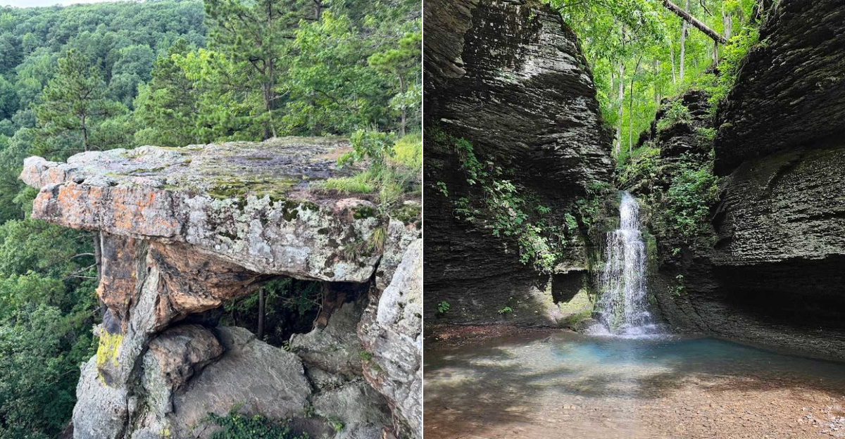
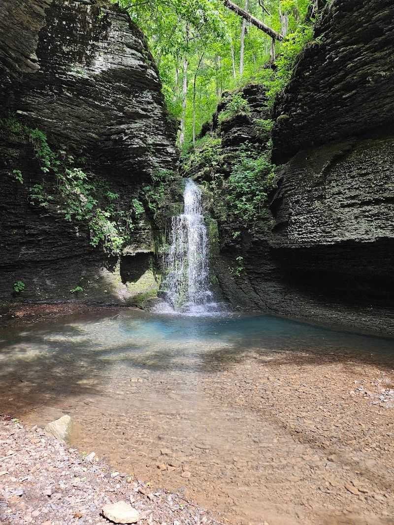
2. Pedestal Rocks Scenic Area
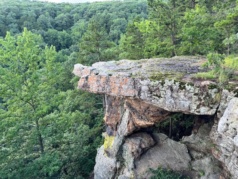
Standing beneath a pedestal rock for the first time is one of those moments that genuinely stops you in your tracks. This scenic area is located along Witts Springs Hwy 16 in Witts Springs, AR 72686.
It sits deep in the Ozark National Forest and rewards visitors with some of the most dramatic rock formations in the entire state. The hike is moderate and spans roughly two miles round trip, making it manageable for most fitness levels.
The pedestal rocks themselves are sandstone pillars that have been carved by centuries of erosion, leaving wide flat tops balanced on narrower bases. When I walked the loop trail, I kept stopping to look up at how these formations seemed almost too perfect to be natural.
The forest floor around them is covered in ferns, and the light filters through the canopy in a way that makes everything feel a little otherworldly.
Spring and fall are the best times to visit because the foliage adds so much color to an already striking landscape. Summer works too, since the tree cover keeps the trail shaded and comfortable even on warmer days.
There are no entry fees, no crowds, and no vendors, just a well-marked trail and some of the most photogenic geology in Arkansas.
Bring water, good shoes, and a fully charged phone camera. The views from the overlook near the formations stretch across the valley below, and on a clear day, the panorama is genuinely breathtaking without being overly dramatic about it.
If you only visit one spot on this list, make a strong case for this one being at the top.
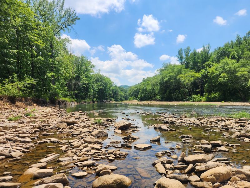
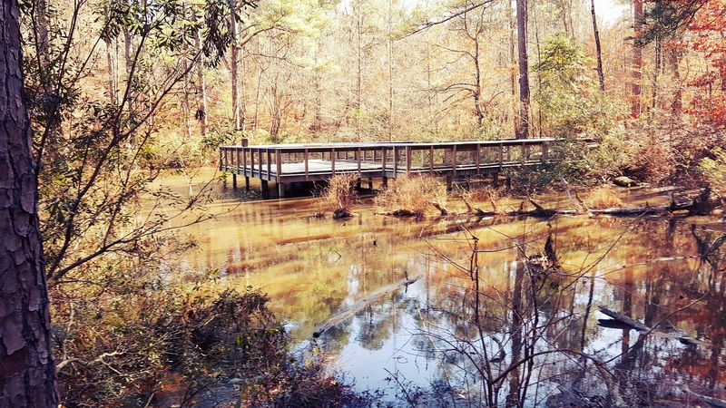
3. Richland Creek Recreation Area
Richland Creek is the place that feels like a well-kept secret even though it has been there for decades. This recreation area is situated along Forest Service Road 1205 near Witts Springs and is part of the Ozark National Forest.
It sits at the edge of the Richland Creek Wilderness. The creek itself is wide, clear, and fast-moving in places, with natural swimming holes that range from shallow to surprisingly deep.
Getting there requires navigating some gravel forest roads, which adds to the sense of discovery when you finally arrive. I remember pulling into the small parking area and hearing the creek before I could see it.
The sound grows louder as you follow the short path down to the water, and the first view of the bluffs rising above the opposite bank is genuinely impressive.
The area is popular with backpackers who use it as a trailhead for the Richland Creek Wilderness, but day visitors are just as welcome. There is a small campground nearby with basic facilities, and the sites along the creek fill up fast during peak season.
Arriving early on weekends makes a real difference if you want a good spot.
Wildlife sightings are common here. I spotted a great blue heron standing perfectly still in the shallows during my visit, and deer tracks were visible along the muddy creek bank.
The combination of rugged terrain, clean water, and genuine solitude makes Richland Creek stand out even among the other excellent recreation areas in this part of Arkansas. Bring comfortable, supportive footwear if you plan to explore the bluffs above the creek.
4. Plum Bayou Mounds Archeological State Park
Few places in Arkansas carry the weight of history quite like Plum Bayou Mounds, also known as Toltec Mounds Archeological State Park. This site is located at 490 Toltec Mounds Road in Scott.
It preserves one of the largest and most complex Native American ceremonial centers in the lower Mississippi Valley. The mounds were built by the Plum Bayou people between approximately 600 and 1050 CE, making this location over a thousand years old.
Walking among the mounds for the first time, I was struck by how large they are up close. The tallest mound rises nearly 49 feet above the surrounding plain, which is remarkable when you consider it was built entirely by hand using baskets of earth carried by workers over many generations.
The scale of the effort required to build this site is genuinely difficult to comprehend.
The visitor center has well-designed exhibits that explain the archaeology of the site and the culture of the people who built it. Guided tours are available and are worth taking because the context they provide completely changes how you experience the mounds.
The site is a National Historic Landmark, which reflects how significant it is from an archaeological standpoint.
The grounds are peaceful and well-maintained, with interpretive signs placed throughout that help visitors understand the layout of the ancient village and ceremonial complex. Photography is encouraged, and the open landscape around the mounds provides clear views in every direction.
This is not a flashy tourist attraction, but it is one of the most genuinely fascinating places I have visited in the state. History lovers and curious travelers will find plenty to absorb here.
5. Redding Recreation Area
There is something special about Redding Recreation Area that is hard to put into words but easy to feel once you are there. This spot is located along AR Highway 215 near Ozark, along the Mulberry River in the Ozark National Forest.
It attracts visitors who appreciate a peaceful setting without the need for organized entertainment. The Mulberry River is one of the most scenic float rivers in the state, and Redding sits right at one of its best access points.
I visited in early fall when the leaves were just beginning to turn, and the reflection of orange and gold in the river was the kind of sight you try to photograph but can never quite capture properly. The campground has both tent and RV sites, though hookups are limited, so checking availability ahead of time is a smart move.
The facilities are clean and well-maintained for a national forest campground.
Canoe and kayak launches are available at the site, which makes it a natural starting point for a float trip downstream. Even if you are not into paddling, the gravel bars along the river are perfect for an afternoon of wading or skipping rocks.
Kids especially tend to have a great time just exploring along the water’s edge.
Fishing is another draw here, with smallmouth bass being the primary target for most anglers. The river runs clear enough in low water that you can actually spot fish moving through the pools.
Redding is one of those places that works equally well for a single overnight trip or a long weekend stay, depending on how much time you can carve out.
6. Cossatot River State Park – Natural Area
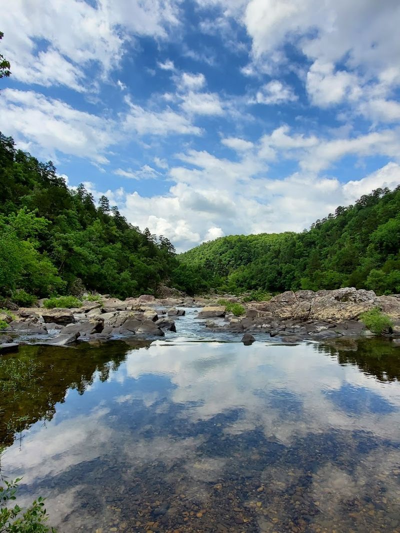
The Cossatot River has a reputation among serious paddlers, and after seeing it in person, it is easy to understand why. This state park and natural area sits at 1980 Hwy 278 West in Wickes, AR 71973.
It protects one of the most ecologically significant rivers in the entire state. The Cossatot is known for its Class III and IV rapids, which draw experienced kayakers from across the region, especially after heavy rainfall when the water levels rise.
Even if whitewater paddling is not your thing, the park offers excellent hiking along trails that follow the river closely. The Cossatot Falls Trail gives hikers a front-row view of the river as it tumbles through a series of rocky chutes and ledges.
The geology here is fascinating, with ancient rock formations that tell a long story about how this landscape was shaped over millions of years.
Swimming is allowed in designated areas when water conditions are safe, and the natural pools carved into the bedrock are stunning. I spent time just sitting on the smooth rocks beside the river, watching the water move through the channels below.
The park is relatively undeveloped, which keeps the experience feeling natural and unfiltered.
Wildlife is abundant throughout the area, including songbirds, wild turkey, and white-tailed deer. The park covers over 4,000 acres, so there is plenty of space to find your own quiet corner.
Spring is the best time to visit for high water and wildflowers, but fall brings cooler temperatures and beautiful color along the ridgelines. Admission to the natural area is free, which makes it one of the best value outdoor destinations in the state.
7. Prairie Grove Battlefield State Park
The Battle of Prairie Grove took place on December 7, 1862, and the ground where it happened has been carefully preserved at Prairie Grove Battlefield State Park. This park is located at 506 East Douglas Street in Prairie Grove.
It covers more than 800 acres and includes original historic structures, a museum, and walking trails that cross the actual battlefield terrain. It is one of the best-preserved Civil War sites in the entire trans-Mississippi theater.
History has a way of feeling more real when you are standing on the ground where it actually happened. Walking across the open fields at Prairie Grove, you can read the landscape the way soldiers would have, noting the ridgelines, the open ground, and the tree lines that provided cover.
The park does an excellent job of using markers and interpretive signage to explain troop movements and key moments in the battle.
The Hindman Hall Museum on site houses an impressive collection of artifacts, uniforms, weapons, and documents related to the battle and the broader Civil War in Arkansas. I spent over an hour in the museum alone before heading out to walk the trails.
The combination of indoor exhibits and outdoor exploration makes this park work well for a half-day or full-day visit.
Historic structures including the Borden House, which was used as a field hospital during the battle, still stand on the property and add a tangible connection to the events of 1862. Special living history events are held throughout the year, including a large reenactment in December.
Even outside of those events, the park is engaging and thought-provoking. Entry is free, making it an accessible stop for anyone traveling through Washington County.
8. Logoly State Park
Logoly State Park holds a distinction that most Arkansas parks cannot claim: it was the first environmental education state park in Arkansas. This park is situated at 131 Columbia Road 459 in Magnolia, in the southern part of the state.
It focuses on natural spring environments, unique plant communities, and hands-on outdoor learning. It is a quieter, more contemplative kind of park compared to the more activity-driven spots in the Ozarks.
The trails here wind through longleaf pine forests and past mineral springs that support rare plant species not commonly found elsewhere in Arkansas. When I walked the longest trail loop, I noticed how different the plant life looked compared to the forests in the northern part of the state.
The understory was dense with native shrubs and wildflowers, and the spring seeps created small patches of marshy ground that were alive with insects and amphibians.
The park has a visitor center with exhibits about the local ecology, and it hosts regular educational programs for school groups and families. Even without a guided program, the interpretive signs along the trails do a solid job of explaining what you are looking at.
The pace here is naturally slow, which is a good thing.
Camping is available at the park with basic facilities, and the campground is rarely crowded. Logoly draws a quieter crowd, mostly nature enthusiasts, birders, and families looking for something educational and peaceful.
The park covers around 368 acres, which is smaller than many Arkansas parks, but the quality of the natural features packed into that space is impressive. It is a place that rewards patience and attention to small details.
9. Historic Dyess Colony: Johnny Cash Boyhood Home
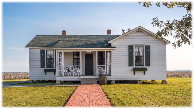
Johnny Cash grew up in a house that most people have never heard of, in a town that most people have never visited. The Historic Dyess Colony at 110 Center Drive in Dyess preserves the Depression-era community where Cash spent his formative years.
The boyhood home has been meticulously restored to reflect how it looked when his family lived there in the 1930s and 1940s. The colony was a New Deal resettlement project, and the story of how it came to exist is fascinating on its own.
Dyess is a small, flat Delta town surrounded by farmland, and arriving there gives you an immediate sense of the landscape that shaped Cash’s music and worldview. The restored home is modest and honestly a little small for a family of eight, which says a lot about the conditions in which Cash grew up.
Every room has been carefully furnished with period-appropriate items, and interpretive panels throughout the house explain key moments in his early life.
Tours are led by guides from Arkansas State University, which manages the site, and they bring the history to life with personal details that go beyond what you might already know about Cash. The colony’s administration building and other original structures have also been restored and are part of the tour experience.
Seeing the community as a whole helps you understand the broader context of Cash’s upbringing.
Fans of Cash’s music will find this deeply moving, but even visitors without a strong connection to his music come away with a new appreciation for both the man and the historical moment that produced him. Admission is affordable, and the drive through the Arkansas Delta to get there is an experience worth having on its own terms.
10. War Eagle Mill
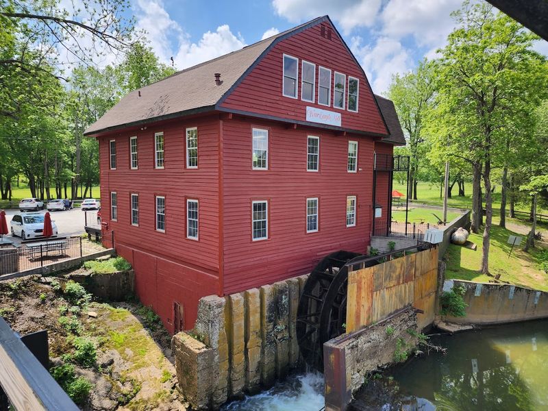
War Eagle Mill has been grinding grain on the War Eagle Creek since the 1830s, which makes it one of the oldest continually operating mills in Arkansas. The current mill building at 11045 War Eagle Rd in Rogers dates to 1973 and was constructed after the previous structure was destroyed by flooding.
The mill is powered by a large overshot waterwheel, and watching it turn while the water rushes beneath it is oddly satisfying in a way that is hard to explain until you see it.
The mill produces stone-ground cornmeal, grits, flour, and other whole grain products that are sold in the on-site store. I picked up a bag of their yellow cornmeal and used it for weeks after my visit, which made the trip feel like it extended well beyond the day itself.
The store also carries local honey, preserves, and handmade goods that make for easy, meaningful gifts.
The property sits beside a covered bridge over War Eagle Creek, and the combination of the mill, the bridge, and the surrounding Ozark hills creates a setting that photographers love. I walked down to the creek bank and spent time watching the water move under the old bridge while the mill wheel turned steadily in the background.
The whole scene has a timeless quality that feels completely removed from modern life.
The mill is also home to the War Eagle Mill Craft Fair, one of the largest outdoor craft fairs in the South, held each spring and fall. Even outside of fair season, the property is worth a visit for the mill tours, the store, and the scenery alone.
It is a working piece of Arkansas history that you can actually interact with, which makes it stand apart from purely preserved historic sites.