11 Beautiful Hiking Trails In Arkansas You Must Explore In 2026
Arkansas surprised me in the best way the first time I headed out on one of its trails. I expected gentle hills and short walks, but instead found dramatic bluffs, hidden waterfalls, and miles of deep green forest.
The Ozark and Ouachita Mountains hold some of the most rewarding hikes I’ve experienced in the South. Every trail feels a little different, which keeps each outing interesting.
Some routes wind through quiet valleys, while others climb toward sweeping river views. A few lead to caves or rock formations that feel almost secret.
I like how easy it is to mix short scenic hikes with longer backcountry adventures. Planning a hiking trip here in 2026 makes perfect sense, especially if you want variety without huge crowds.
These trails stand out for their scenery and memorable terrain, and each one offers a reason to explore Arkansas on foot.
1. Whitaker Point (Hawksbill Crag) Trail
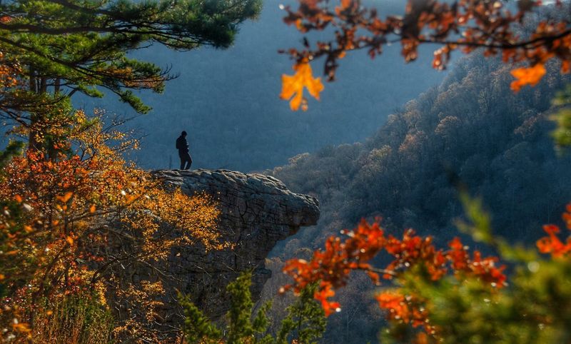
Standing on the edge of Hawksbill Crag felt like the earth had dropped away beneath my feet, leaving nothing but open sky and miles of rolling forest stretching in every direction. The trailhead sits along Cave Mountain Road off Newton County Road 5, near Ponca, AR, and the hike itself is about 2.8 miles round trip with modest elevation gain.
I remember arriving just before sunrise and watching the mist roll through the valley below like something out of a painting.
The trail winds through a mixed hardwood forest before opening up dramatically at the crag. Footing can be rocky in spots, so sturdy shoes are a must.
Most hikers complete the route in under two hours, making it very approachable even for those who do not hike regularly.
What makes this spot so magnetic is that photograph-worthy overhang that seems to float above the tree canopy. Fall color season turns the surrounding hills into a patchwork of red, orange, and gold that frames the crag beautifully.
Arriving early on weekdays helps you avoid the crowds that naturally gather at one of Arkansas’s most iconic overlooks.
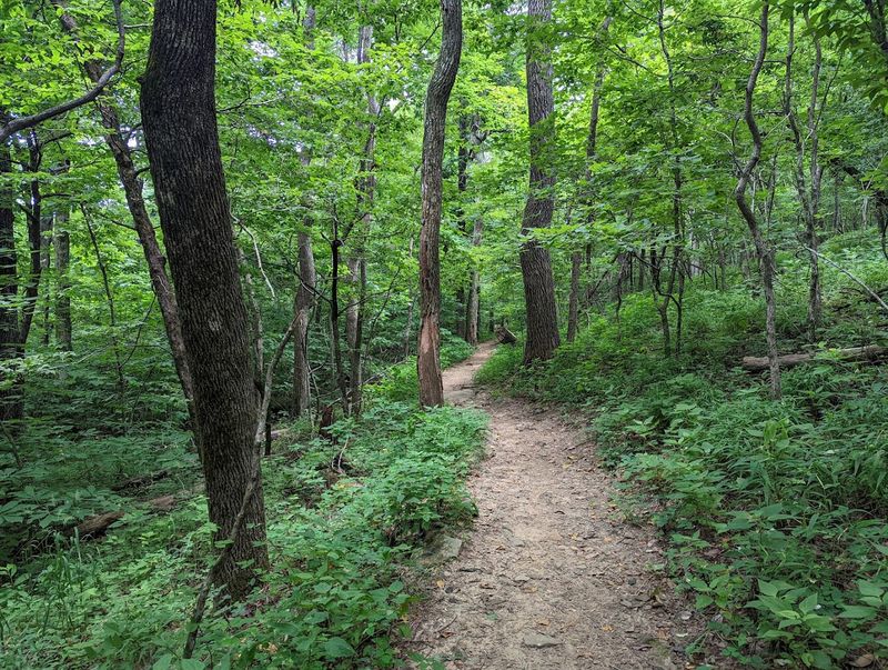
2. Lost Valley Trail
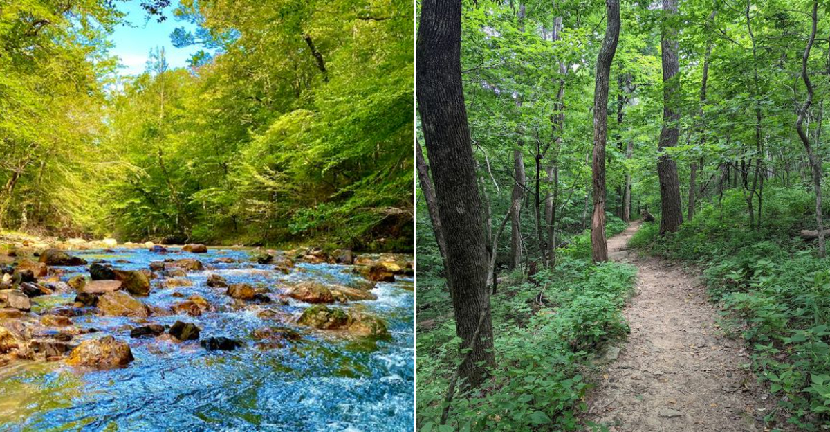
Lost Valley Trail earns its reputation as one of the most rewarding short hikes in the Arkansas Ozarks, packing waterfalls, a natural cave, and towering bluff walls into just 2.2 miles round trip. The trailhead is located off Highway 43 in Ponca, AR 72670, and parking fills up quickly on weekends, so an early start really pays off.
I walked this trail on a cool spring morning and found the whole canyon glowing with fresh green leaves and the sound of running water everywhere.
The path follows Clark Creek upstream through a narrow valley that feels completely enclosed by sandstone walls draped in moss and ferns. Eden Falls appears near the trail’s end, and just behind it lies a cave large enough to walk into.
Bringing a headlamp lets you explore the cavern and spot the upper falls hidden inside.
Families with kids tend to love this trail because the rewards come quickly and the terrain stays manageable throughout. The mix of geological features packed into such a short distance makes every step feel purposeful.
Lost Valley is the kind of place where you slow down naturally, take your time, and find yourself stopping constantly to look around in quiet appreciation.
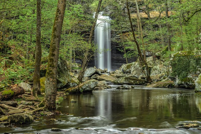
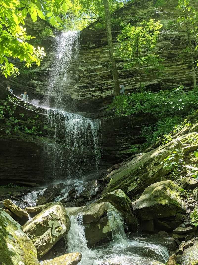
3. Hemmed-In Hollow Trail
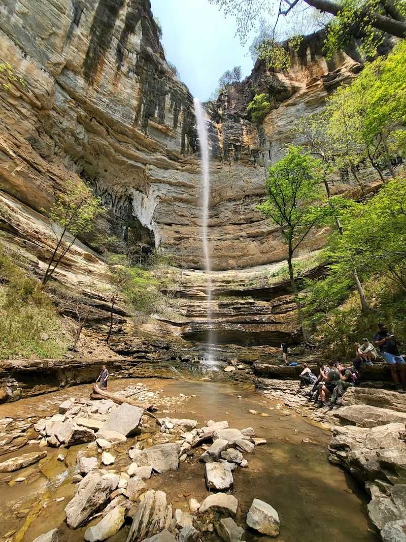
Hemmed-in Hollow is home to the tallest waterfall between the Rocky Mountains and the Appalachians, and reaching it feels like a true earned reward. Access begins at the Compton Trailhead off AR-43 in Compton, AR 72624, and the round trip clocks in around 6.8 miles with a significant elevation change that will definitely get your legs working.
I tackled this trail on a crisp October morning, and the effort involved made arriving at that 209-foot waterfall feel genuinely spectacular.
The route descends steeply into the Buffalo River canyon, passing through dense hardwood forest before the sound of falling water signals you are getting close. Standing at the base of the falls, the surrounding bluff walls rise so high that the sky above looks almost narrow.
The spray keeps the ground cool and the air fresh even on warm days.
Planning ahead matters on this trail. Solid hiking boots, plenty of water, and snacks for the climb back up are all worth packing.
The trail is moderately challenging and not ideal for very young children, but experienced hikers will find the payoff absolutely worth every step of elevation gained on the return. Spring snowmelt turns the falls into a thundering curtain of white water.
4. Big Bluff / Goat Trail (Centerpoint Trailhead)
Walking the Goat Trail along the face of Big Bluff is one of those experiences that stays with you long after the trip is over. The Centerpoint Trailhead sits at the Firetower Road junction off Highway 43 in Compton, AR 72624, and from there it is roughly 10 miles round trip to reach the bluff section and return.
I remember the moment the tree cover broke and the narrow ledge trail appeared, carved right into the cliff face with the Buffalo River glittering hundreds of feet below.
Big Bluff is considered the tallest bluff above any river in the United States outside of the Grand Canyon, which puts the views into remarkable perspective. The Goat Trail portion is genuinely narrow and requires careful footing, but it is not technical climbing.
Moving slowly and watching your step makes it completely manageable for fit, attentive hikers.
The surrounding forest is beautiful throughout the entire route, with hardwoods giving way to open cedar glades near the bluff. Early morning light hits the river valley in a way that makes the whole scene look almost unreal.
This is the kind of trail that reminds you why Arkansas deserves far more attention than it typically gets from the wider hiking community.
5. Eagle Rock Loop
The Eagle Rock Loop is widely regarded as one of the finest backpacking trails in the entire South, and spending time on it makes that reputation easy to understand. The trail begins at the Albert Pike Day Use Area, accessible via Forest Road 106 off AR-369 near Langley, AR, and the full loop covers approximately 26 miles through the heart of the Ouachita National Forest.
I completed it over three days and found the combination of creek crossings, rocky ridgelines, and dense pine forest genuinely captivating throughout.
The Little Missouri River runs alongside portions of the trail, and several creek crossings add a bit of adventure to each day on the path. Campsites along the route are primitive but plentiful, with flat ground and access to water making each night comfortable.
Spring wildflowers carpet the forest floor in the lower sections, adding unexpected bursts of color to the green canopy above.
This trail is best suited to hikers with some backpacking experience, as the terrain is rugged and navigation requires attention. Trekking poles are genuinely helpful on the rockier ridge sections.
The Eagle Rock Loop rewards patience and preparation with a wilderness experience that feels miles away from everyday life, even though it is reachable within a few hours from many Arkansas cities.
6. Seven Hollows Trail
Petit Jean State Park holds a special place in Arkansas hiking history as the state’s first state park, and the Seven Hollows Trail is one of its most rewarding routes. The park is located at 1285 Petit Jean Mountain Road in Morrilton, AR 72110.
This trail stretches about 4.5 miles through a series of connected sandstone canyons that each feel distinct from the last. Walking through the hollows feels like stepping into a world that has barely changed in centuries.
Natural rock tunnels, cedar groves, and mossy canyon walls appear around nearly every bend. The trail is rated moderate, with some scrambling over rocks and a few stream crossings that keep things interesting without becoming overwhelming.
I found the middle section of the hike particularly striking, where the canyon walls narrowed and the light filtered down in long, warm shafts through the tree canopy.
Wildlife sightings are common here, from deer moving quietly through the understory to red-tailed hawks circling above the canyon rims. The trail connects to other park paths, giving hikers the option to extend their day if energy allows.
Arriving in the morning on a weekday gives you the best chance of having the hollows mostly to yourself, which makes the whole experience feel remarkably peaceful and unhurried.
7. Cedar Falls Trail
Cedar Falls is the kind of waterfall that stops you in your tracks the moment it comes into view. Also within Petit Jean State Park at 1285 Petit Jean Mountain Road in Morrilton, AR 72110, this trail is about 2 miles round trip.
It leads to a 95-foot waterfall that drops into a stunning sandstone bowl. The path is well-maintained and accessible to most fitness levels, making it one of the most visited trails in the park for good reason.
The trail descends from the canyon rim through a forested slope before leveling out near the base of the falls. A wooden viewing platform gives you a clear, unobstructed look at the full drop without requiring any scrambling.
I visited after a rainy week, and the volume of water coming over the edge was genuinely impressive, filling the amphitheater with a constant roar and a fine cooling mist.
Even during drier months, Cedar Falls maintains enough flow to be photogenic and worth the short walk down. The surrounding sandstone walls are streaked with mineral colors ranging from rust red to pale cream, which adds visual depth to the scene.
Combining this trail with the Seven Hollows Trail on the same day makes for a full and satisfying hiking experience within the park without requiring an early start or advanced fitness.
8. Signal Hill Trail
Reaching the top of Mount Magazine means standing at the highest point in Arkansas, and Signal Hill Trail is the most direct route to get there. The trailhead is at Mount Magazine State Park, located at 16878 AR-309 in Paris, AR 72855, and the trail itself is a manageable 1.8 miles round trip with steady but not punishing elevation gain.
I made this climb on a clear November afternoon and the 360-degree views from the summit were nothing short of extraordinary.
The Arkansas River Valley spreads out to the north and the Ouachita Mountains roll away to the south, creating a panorama that rewards every step of the climb. The summit sits at 2,753 feet, making it genuinely the rooftop of the state.
Rocky outcroppings near the top provide natural seating for a lunch break while you take in the view from every angle.
The park itself offers excellent facilities including a lodge, cabins, and a visitor center, making Signal Hill an easy trail to incorporate into a longer weekend stay. The trail passes through shortleaf pine and oak forest, which turns vivid shades of amber and red in autumn.
Photographers particularly love the golden hour light that sweeps across the valley just before sunset, casting long shadows across the rocky summit plateau.
9. Yellow Rock Trail
Devil’s Den State Park is already one of Arkansas’s most beloved parks, and the Yellow Rock Trail gives you the best elevated view the park has to offer. The park entrance is at 11333 West Arkansas Highway 74 in West Fork, AR 72774.
The Yellow Rock Trail is approximately 3 miles round trip with enough elevation change to feel like a real workout. The trail climbs steadily through a forest of oak and hickory before arriving at the warm-toned sandstone outcropping that gives the trail its name.
The rock itself glows with shades of yellow and orange that become even more vivid in late afternoon light. From the overlook, you can see the park’s lake and the forested ridges of the Boston Mountains stretching away in the distance.
I found a quiet corner of the rock to sit for a while and simply take it all in, which felt like the right pace for a place this beautiful.
The lower portions of the trail connect to the park’s cave and crevice area, where narrow sandstone passages invite exploration at a slower, more curious pace. Combining both sections into a single loop makes for a well-rounded visit that highlights what makes Devil’s Den so consistently popular.
The park also has excellent camping facilities for anyone wanting to extend the trip into an overnight adventure.
10. Sunset Trail
Hot Springs National Park is the oldest federally protected land in the United States, and the Sunset Trail offers the most immersive way to experience its forested interior on foot. The trail is accessible from the Fordyce Bathhouse Visitor Center at 369 Central Avenue in Hot Springs, AR 71901.
The full loop covers about 10 miles through the park’s surprisingly wild backcountry. I was genuinely caught off guard by how quiet and remote the trail felt given that it sits within a busy tourist city.
Tall shortleaf pines and hardwoods create a dense canopy that keeps the trail cool even in summer. The route passes over several forested ridgelines with occasional open views toward the surrounding Hot Springs area.
Wildflowers bloom along the lower sections in spring, and the fall foliage on this trail tends to peak later than in the Ozarks, extending the color season well into November.
The trail can be broken into shorter segments for those who prefer a less ambitious outing, with several connection points to park roads. Wildlife is active throughout, and deer sightings are common in the early morning hours.
The unique combination of natural forest, thermal spring history, and accessible urban trailheads makes Sunset Trail one of the most interesting and underappreciated hiking experiences in the entire state of Arkansas.
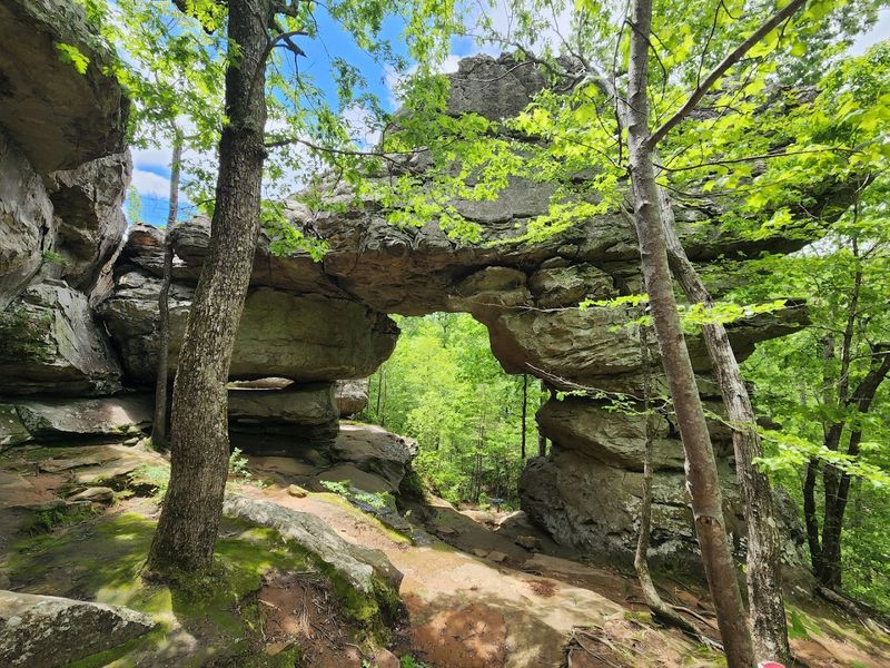
11. Alum Cove Natural Bridge Trail
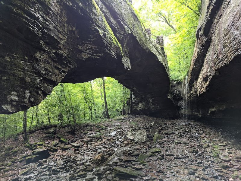
Few geological features in the Ozarks match the quiet grandeur of the Alum Cove Natural Bridge, a 130-foot sandstone arch that has been quietly standing in the hills of Newton County for thousands of years. The trailhead is at the Alum Cove Natural Bridge Recreation Area off Newton County Road 28 near Deer, AR, and the main loop trail is a gentle 1.5 miles that makes this accessible to almost every hiker.
I walked it on a humid summer morning when the forest was fully leafed out and the light filtering through the canopy was soft and green.
The arch itself appears gradually as the trail curves through a mossy hollow, and the first full view of it is genuinely striking. Ferns and wildflowers grow thickly around the base, and the sandstone surface of the bridge is textured with layers that tell a long geological story.
A short spur trail takes you up and over the top of the arch, giving a completely different perspective on the surrounding hollow below.
The recreation area is managed by the Ozark National Forest, and the facilities are simple but well kept. Interpretive signs along the route explain the geology and natural history of the area in an engaging, easy-to-follow way.
This trail is a wonderful choice for families, casual hikers, or anyone wanting a memorable natural landmark without committing to a full day of strenuous hiking.