2026 Bucket List Hikes In Arkansas With Big Scenic Rewards And No Permit Needed
The moment my boots hit an Arkansas trail, I know I’m in for a good view before long. It might be a bluff stretching over the river valley or a waterfall spilling through a quiet canyon.
I’ve spent years hiking around the state, and one thing still surprises me. Big scenery here often comes without complicated planning.
Many of my favorite trails don’t require permits at all. I can wake up, grab my pack, and be on the trail a couple of hours later.
Arkansas offers a lot of variety for hikers. One day I’m climbing to a mountaintop overlook.
Another day I’m following a creek through mossy rock walls and thick forest. The landscapes change quickly, which keeps every trip interesting.
The hikes below are ones I return to often. Each one delivers a strong scenic payoff and can be enjoyed without dealing with permits or reservations.
1. Cedar Falls Trail, Morrilton
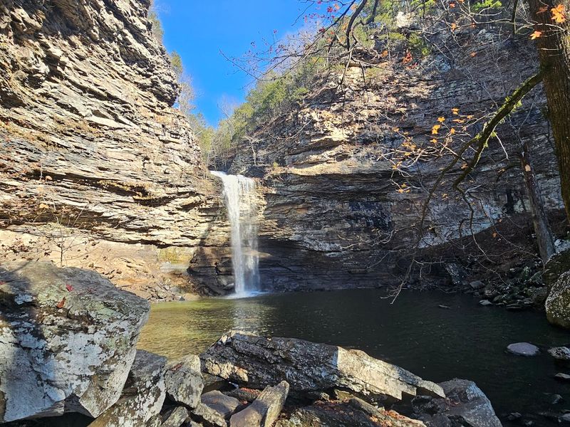
Standing at the base of Cedar Falls and feeling that cool mist hit your face on a warm Arkansas afternoon is one of those moments that makes you forget you ever had a to-do list.
Cedar Falls Trail is located at Petit Jean State Park, 1285 Petit Jean Mountain Road, Morrilton, AR 72110, and it leads you to one of the most photographed waterfalls in the entire state.
The falls drop roughly 89 feet over a wide sandstone ledge into a shallow pool below, creating a scene that genuinely stops people mid-stride.
The trail itself runs about 2.1 miles round trip, making it accessible for most fitness levels while still delivering a serious visual payoff at the end.
Footing can get slippery near the base of the falls, so waterproof trail shoes or boots with solid grip are a smart call before you head out.
Spring is the peak season for flow volume, when snowmelt and rain push the falls to their most dramatic state, though the trail stays beautiful year-round.
No permit is required to hike Cedar Falls Trail, and the park charges a standard Arkansas State Parks day-use fee rather than any trail-specific fee.
Parking fills up fast on weekends, so arriving before 9 a.m. gives you the best shot at a spot close to the trailhead.
Once you round that final bend and the falls come into view, the only thing you will regret is not bringing a better camera.
2. Rock House Cave Trail, Morrilton
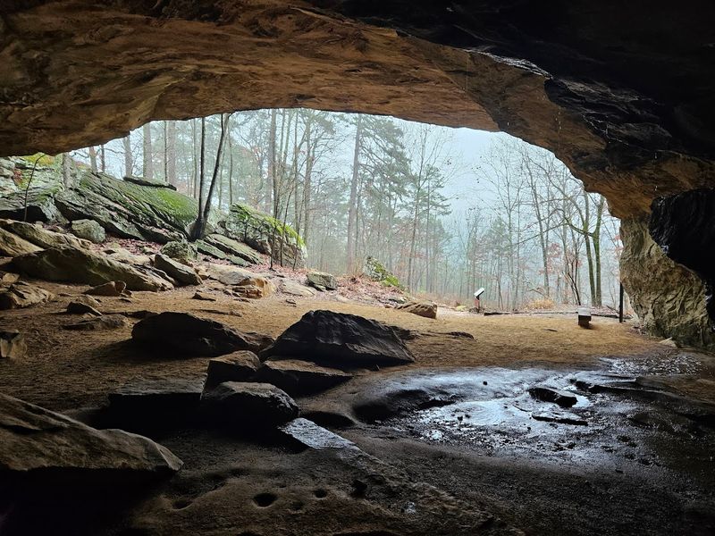
Petit Jean State Park holds more than one showstopper, and the Rock House Cave Trail proves that point with a prehistoric exclamation that no history buff can walk past unmoved.
Found at the same address as Cedar Falls, 1285 Petit Jean Mountain Road, Morrilton, AR 72110, this trail leads hikers to a massive sandstone cave shelter decorated with Native American pictographs estimated to be hundreds of years old.
The cave itself stretches wide enough to shelter a small crowd, with a ceiling that arches overhead in smooth, rust-colored stone that has witnessed centuries of human presence.
The Rock House Cave Trail is a short walk of roughly 0.3 miles round trip, following a paved path through hardwood forest before arriving at the massive sandstone rock shelter along the canyon wall.
Standing inside and looking up at those ancient markings painted in red pigment is a genuinely humbling experience that no photograph fully captures.
Rangers ask that visitors stay on the designated path inside the cave to protect both the pictographs and the fragile soil underneath, so please respect those boundaries.
No permit is needed to hike this trail, and it shares access with the broader Petit Jean trail network, making it easy to combine with Cedar Falls for a full day of exploration.
Fall is a particularly rewarding time to visit, when the surrounding forest turns gold and orange and frames the cave entrance in warm color.
History, art, and nature rarely share a stage this well, and Rock House Cave pulls it off without trying too hard.
3. Yellow Rock Trail, West Fork
Few trail names in Arkansas deliver on their promise as literally as Yellow Rock Trail, where the payoff is a massive, honey-colored sandstone outcropping jutting out over a stunning river valley panorama.
The trailhead is located within Devil’s Den State Park at 11333 West Arkansas Hwy. 74, West Fork, AR 72774, a park that already earns its reputation as one of the most scenic in the state.
Yellow Rock itself sits at around 1,800 feet in elevation, and the view from the top stretches across the Lee Creek valley in a sweeping arc that rewards every step of the climb to get there.
The trail runs approximately 2.8 miles round trip with a moderate elevation gain, making it a solid half-day adventure for most hikers.
The sandstone surface of Yellow Rock can become dangerously slick after rain, so checking the forecast before your visit is a practical habit worth forming.
Devil’s Den State Park is also famous for its network of crevices and caves at lower elevations, meaning you can easily turn this into a full-day itinerary by exploring the park’s other features after the hike.
No permit is required to access Yellow Rock Trail, and Devil’s Den charges no day-use fee for hiking, which makes it one of the most budget-friendly big-view hikes in the region.
Sunset timing in late spring and early fall lights up that golden rock in a way that photographers genuinely plan trips around.
If your legs are asking why you pushed this hard, the view at the top will answer them immediately.
4. Rim Trail, Dardanelle
Perched at the top of Mount Nebo, the Rim Trail delivers one of the most complete 360-degree perspectives available on any no-permit hike in Arkansas, and the views of Lake Dardanelle below are the kind that make your jaw do something embarrassing.
The trailhead is accessible from Mount Nebo State Park at 16728 West State Hwy. 155, Dardanelle, AR 72834, a park that sits dramatically atop a flat-topped mountain rising about 1,350 feet above the surrounding valley.
The Rim Trail itself loops around the perimeter of the mountaintop for roughly 3.5 miles, offering constantly shifting perspectives of the Arkansas River Valley, Lake Dardanelle, and distant ridgelines to the north and south.
Because the trail hugs the edge of the plateau, you get sweeping vistas at regular intervals rather than just one grand finale, which keeps the energy of the hike high throughout.
Wildflowers bloom along the rim from late March through May, adding splashes of color to an already dramatic landscape that feels almost cinematic in good light.
The road up to Mount Nebo is steep and winding, so drivers with a fear of switchbacks may want to take a breath before the ascent, though the drive itself rewards you with preview views before you even park.
No permit is required, and Mount Nebo State Park is part of the Arkansas State Parks system, meaning standard access applies without trail-specific fees.
Every bend in the Rim Trail feels like the park is showing off, and honestly, it has every right to.
5. West Summit Trail, Little Rock
Pinnacle Mountain earns its name the hard way, and anyone who scrambles to the top of the West Summit Trail earns a view of the Arkansas River and the Little Rock skyline that feels like a proper reward for the effort.
The trail begins at Pinnacle Mountain State Park, 11901 Pinnacle Valley Road, Little Rock, AR 72223, just a short drive west of the city, making it one of the most accessible big-summit hikes in any state capital in the country.
The West Summit route climbs about 1,000 feet in elevation over roughly 1.5 miles one way, and the upper section involves scrambling over loose quartzite boulders that require both hands and solid footing.
That boulder scramble near the top is what separates the West Summit Trail from a casual stroll, and it tends to sort out the hikers who came prepared from those who maybe underestimated the cone-shaped peak from the parking lot.
The 360-degree view from the summit includes the Arkansas River, Maumelle Lake, and on clear days, downtown Little Rock glinting in the distance.
Early mornings on weekdays are the quietest window to hike this trail, since its proximity to the city means weekend crowds can build up quickly by mid-morning.
No permit is required, and Pinnacle Mountain State Park charges no day-use fee for hiking, which makes this one of the most cost-effective summit experiences in the region.
Once you catch your breath at the top, the city spread out below you will look surprisingly small and surprisingly beautiful at the same time.
6. North Rim Trail, Paris
Mount Magazine is the highest point in Arkansas, and the North Rim Trail runs along its northern edge with a series of overlooks that remind you exactly why elevation matters when it comes to scenery.
The trailhead is located at Mount Magazine State Park, 16878 AR-309, Paris, AR 72855, where the mountain tops out at 2,753 feet and the surrounding landscape drops away in every direction into deeply forested valleys.
The North Rim Trail stretches approximately 1.7 miles one way, tracing the edge of the plateau past multiple signed overlooks where the Arkansas River Valley spreads out far below in a patchwork of farms and forest.
One of the most striking things about this trail is how the overlooks keep changing character as you move along the rim, with some offering open sky views and others framing the valley through curtains of cedar and oak.
Peregrine falcons have been spotted nesting along the bluffs here, which adds a wildlife dimension to the hike that serious birders absolutely should not sleep on.
The higher elevation also means noticeably cooler temperatures compared to the valley floor, which makes the North Rim Trail a genuinely smart choice for summer hiking when lower trails feel punishing.
No permit is required to hike the North Rim Trail, and Mount Magazine State Park offers free trail access as part of the Arkansas State Parks network.
The kind of quiet you find up here on a weekday morning is rare enough that it almost feels like a secret worth keeping to yourself.
7. Lovers’ Leap Trail, Mena
Rich Mountain in the Ouachita range holds a classic with a dramatic name, and the Lovers’ Leap Trail at Queen Wilhelmina State Park delivers a payoff that matches the legend stitched into its identity.
The park sits at 3877 Highway 88 West, Mena, AR 71953. At about 2,681 feet, Rich Mountain is one of the highest peaks in the Ouachita Mountains, giving this trail a high-elevation feel that sets it apart from many hikes in the region.
The Lovers’ Leap overlook itself juts out over a sheer drop with a panoramic view of the rolling Ouachita ridgelines that stretch south toward Oklahoma in an almost endless procession of green.
The trail to the overlook is relatively short and manageable, making it a great option for hikers who want a significant view without committing to a full backcountry day.
Queen Wilhelmina State Park has an interesting history tied to Dutch royalty, as the park was originally built as a railroad resort hotel in the 1890s intended to attract European tourists, a detail that adds a quirky layer to what is already a memorable mountain destination.
Fall foliage on Rich Mountain typically peaks in mid-October, when the hardwood forests surrounding the trail turn a deep, saturated mix of red, orange, and gold that photographers plan entire road trips around.
Arkansas State Parks do not charge a day-use fee, and no permit is required to hike the trail.
Standing at the overlook with the Ouachitas rolling out to the horizon, the name suddenly feels less dramatic and more like an accurate description.
8. Lost Valley Trail, Ponca
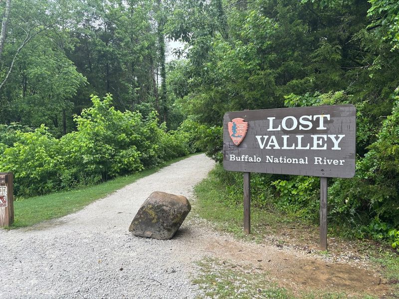
Tucked into the Buffalo National River corridor near the tiny community of Ponca, the Lost Valley Trail packs more geological drama into a short distance than most hikes manage in twice the mileage.
The trailhead is located on Hwy. 43, approximately 1.5 miles south of Ponca, AR 72670, in one of the most scenic corners of the Ozark Mountains in the entire country.
The trail runs about 2 miles round trip through a narrow, winding canyon carved by Clark Creek, passing towering bluffs, a natural bridge, a hidden waterfall inside a cave, and a final cavern large enough to walk into.
That combination of features in under a mile of one-way hiking is genuinely unusual, and it makes Lost Valley Trail one of the most story-rich short hikes in Arkansas without any competition.
The cave at the end of the trail, known as Eden Falls Cave, shelters a waterfall that drops inside the cavern itself, and reaching it requires a short but memorable crawl through a low passage that rewards the adventurous.
Water levels in Clark Creek can rise quickly after heavy rain, so checking weather conditions before visiting is a practical step rather than an optional one.
No permit is required to hike Lost Valley Trail, and as part of the Buffalo National River system managed by the National Park Service, the trail is free to access without any day-use fee.
By the time you walk back out of that canyon, you will be mentally rearranging your hiking priority list to put this one much closer to the top.