This 8-Mile Hike In Colorado Will Lead You To Hidden Alpine Lakes
This hike has the personality of a show-off, and honestly, it earns it. The first stretch feels almost polite, easing you beneath towering pines with that crisp, need-a-deeper-breath kind of air that makes the outside world disappear fast.
Then the trail starts revealing its tricks. Waterfalls crash into the scene with zero interest in being subtle, rocky climbs wake up your legs, and every turn seems determined to outdo the last one.
In Colorado, that kind of escalating drama feels almost unfair, like nature is piling on just to see how impressed you can get. Then the lakes appear.
Clear, cold, and glowing like they were designed by someone with no respect for realism, they stop you in your tracks. Colorado knows how to reward effort, and this trail does it with a grand finale that feels almost ridiculous in the best possible way.
You start with a hike and end with a full blown mountain victory lap.
Where The Trail Begins: Knowing Your Starting Point
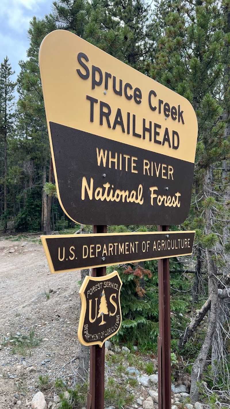
First things first: the trailhead sits at 1160 Spruce Creek Rd, Breckenridge, Colorado 80424, accessed via a bumpy gravel road that will rattle your coffee thermos and test your vehicle’s suspension in equal measure. The parking area fills up at a speed that would impress a sold-out concert venue, so arriving before 8 a.m. on weekends is less of a suggestion and more of a survival strategy.
Parking here is free, which feels almost suspiciously generous given what awaits you.
One critical tip that visitors wish they had known earlier: when you reach the large map board at the trailhead, do not follow the rocky 4×4 road uphill. Turn around, cross the parking lot, and you will find the actual trail right there waiting patiently.
Many hikers have made the mistake of grinding up that rough vehicle road only to spot the proper trail on the way back down.
Pro Tip: The trail starts at approximately 10,200 feet elevation. Give your lungs a heads-up before you go.
Free parking available. Arrive by 7-8 a.m. on weekends.
Look for the map board, then cross the lot for the true trailhead.
The First Two Miles: Forest Walking With Easy Grades

Once you find the correct trail start, the first two miles reward you handsomely for your early alarm. The path winds through pine forest with gradual elevation gain, roughly 500 feet over those opening miles, which means your legs feel capable and your confidence climbs faster than the terrain.
The trees stand tall and close, creating a tunnel of cool shade that makes the whole thing feel like walking through a very well-decorated hallway.
The trail surface here is a mix of dirt, tree roots, and loose rocks, so footing deserves your attention even when the grade is gentle. Trekking poles earn their pack weight on this stretch.
Wildlife sightings are genuinely possible, and at least one visitor has reported spotting a bull moose along this section, which is the kind of story that makes the whole trip worth telling at dinner.
Best For: Families with older kids and hikers easing into the altitude before the real climbing begins.
Gradual elevation gain through shaded pine forest. Watch for tree roots and loose rocks underfoot.
Wildlife, including moose, occasionally spotted along this section.
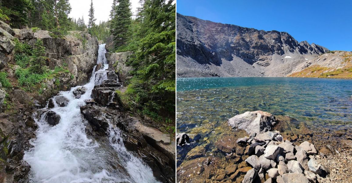
Continental Falls: The Trail’s First Big Payoff
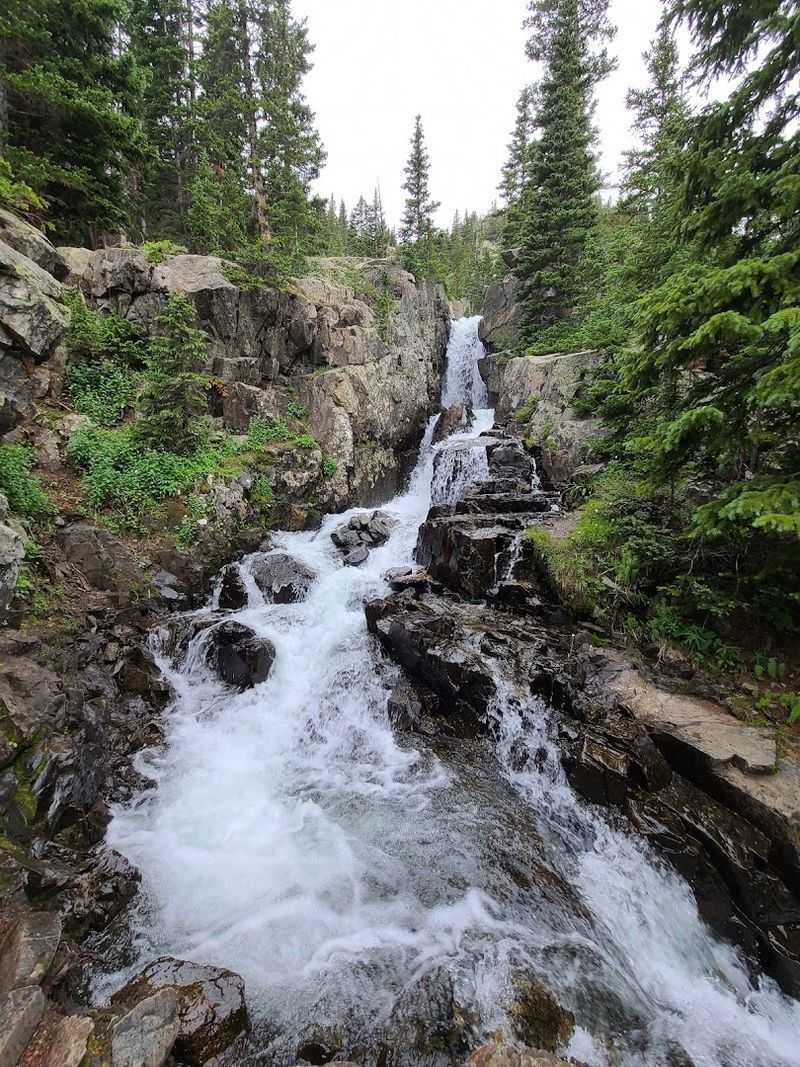
Around the midpoint of the hike, the trail delivers its first standing ovation moment: Continental Falls. Short side paths branch off the main route to bring you close enough to feel the mist and hear the roar of water crashing over dark rock.
It is the kind of waterfall that makes people stop mid-sentence and just stare, which is a perfectly acceptable reaction.
The falls mark a natural rest spot before the terrain shifts gears entirely. Up to this point, the hike has been a reasonably manageable conversation between you and the mountain.
After the falls, that conversation gets considerably more direct. Old cabin ruins and remnants of gold mining history dot the landscape along this stretch, giving curious hikers something to study while catching their breath.
Insider Tip: The trail can become slippery after rain near the falls area, so rubber-soled boots with grip are not optional equipment here.
Short side paths lead to close-up views of the falls. Historic mining cabins and equipment visible along the route.
Trail surface gets rockier and steeper past this point. Great natural rest and snack stop before the final push.
The Rocky Scramble: What the Last 800 Feet Really Ask of You
Nobody is going to sugarcoat this part for you, and honestly that would be doing you a disservice. The final approach to the lakes involves roughly 800 feet of elevation gain that is best described as a genuine rock scramble.
Loose boulders, steep pitches, and a trail that occasionally forgets to mark itself clearly combine to create the section that separates a casual stroll from a proper mountain achievement.
The altitude, which climbs from around 10,200 feet at the trailhead to approximately 11,800 feet at the upper lake, will make itself known here. Visitors who live at lower elevations report feeling winded quickly, and even those who gave themselves several days to acclimate in Breckenridge describe this stretch as genuinely challenging.
Slow and steady is not just a cliché here; it is the actual correct strategy.
Common Mistakes to Avoid:
Rushing the scramble section without adequate rest breaks. Skipping altitude acclimation before attempting the full hike.
Underestimating water needs: bring at least 2 to 3 liters per person. Starting late and hitting afternoon mountain weather near the exposed upper section.
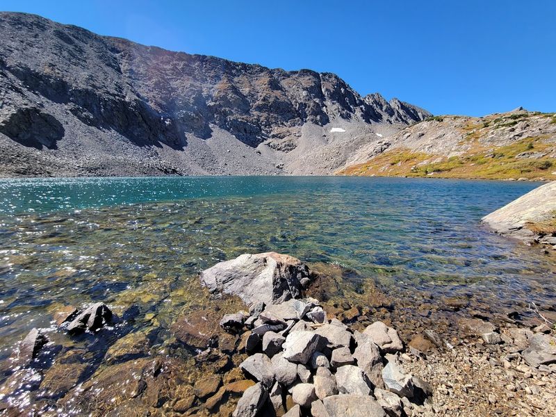
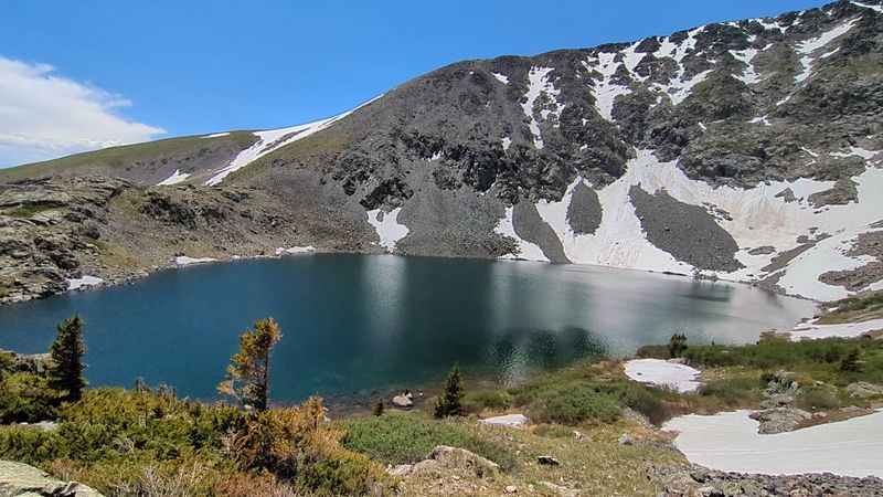
Lower Mohawk Lake: The First Reward That Stops You Cold

When Lower Mohawk Lake finally appears above the boulder field, the reaction from most hikers falls somewhere between audible gasping and complete silence. The lake sits in a rocky alpine bowl with mountain peaks rising sharply around it, its water running clear and cold in a way that makes the whole scene look slightly too perfect to be real.
Trout swim visibly in the shallows, which adds a lively, almost cinematic quality to the stillness.
This is the point where the crowds thin noticeably. The bulk of day hikers stop here, spread out along the shoreline, and eat their well-earned sandwiches while staring at views that no phone camera fully captures.
Families with younger children who made it this far deserve serious credit; one family completed the hike with a 9-year-old and a 12-year-old, though the trip took around five hours round-trip at their pace.
Who This Is For: Anyone willing to push through the scramble section earns this view. It is not a beginner trail, but it rewards moderate hikers who pace themselves and come prepared.
Clear alpine lake with visible trout. Natural rest and turnaround point for many hikers.
Crowds thin significantly past this point.
Upper Mohawk Lake: The One That Makes the Whole Trip Legendary
If Lower Mohawk Lake is the headline act, Upper Mohawk Lake is the encore that the whole crowd came hoping for. Sitting higher still in the basin, the upper lake rewards those who keep moving past the lower one with an almost startling sense of remoteness and raw alpine drama.
The peaks rise sharply around it, the wind picks up with genuine authority, and the temperature drops enough that the jacket stuffed in the bottom of your pack suddenly becomes your best friend.
Visitors consistently describe Upper Mohawk Lake as the single most impressive payoff on the entire trail. One hiker noted that coming from sea level and reaching the upper lake in under a day felt like a personal milestone worth celebrating.
The trail markings become sparse in this final stretch, so the AllTrails app or a downloaded offline map is a genuinely useful tool rather than an optional luxury.
Planning Advice: Start no later than 7 a.m. if Upper Mohawk Lake is your goal. Afternoon thunderstorms are common in Colorado summers, and the exposed upper basin is no place to be when weather moves in fast.
More remote and dramatically scenic than the lower lake. Bring an extra layer: wind and cold increase significantly at this elevation.
Download offline maps before leaving cell service range.
Wildflowers, Wildlife, and What Else the Trail Throws In
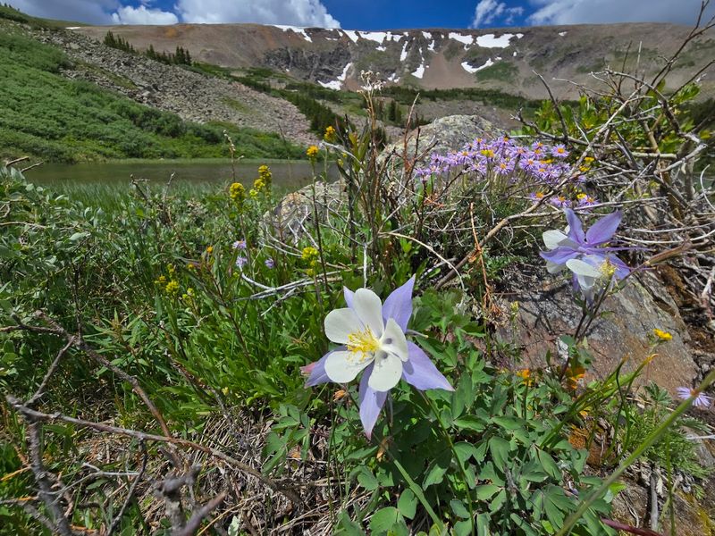
Mid-July on this trail is a bonus round nobody fully advertises. Wildflower patches appear along the route in bursts of color that feel almost extravagant given the rocky terrain surrounding them.
The blooms show up particularly well in the stretch between the Mayflower Trail junction and the lower lake, turning what could be a grim slog into something genuinely pretty. Bug spray is not optional during summer months; the mosquitoes at this elevation are large, numerous, and deeply committed to their work.
Wildlife adds an unpredictable element to the experience. Moose have been spotted in the lower forested sections, and the lakes themselves attract fishing enthusiasts who stand knee-deep in the cold water with the calm patience of people who have genuinely figured something out.
The whole trail has a layered quality, meaning each visit can feel different depending on the season, the weather, and how early you manage to drag yourself out of bed.
Quick Verdict: The trail is best hiked between late May and early September, with mid-July offering the fullest wildflower display and most reliable trail conditions.
Wildflowers peak around mid-July. Bug spray is essential from late spring through summer.
Fishing is popular at both lakes. Trail conditions vary significantly by season.
Final Verdict: What To Pack and How To Make This Hike Work

Getting this hike right comes down almost entirely to preparation, and the gap between a miserable day and a genuinely memorable one is usually just a few smart choices made the night before. Water is the non-negotiable starting point: bring 2 to 3 liters per person, because the elevation and exertion will drain you faster than you expect.
Sturdy hiking boots with real ankle support handle the rocks and roots far better than trail runners, and a rain poncho packs small enough to forget about until you desperately need it.
Trekking poles reduce the strain on knees during the descent, which is the part of the hike most people forget to plan for. Sunglasses, sunscreen, a snack substantial enough to qualify as a meal, and an extra pair of dry socks round out the kit.
The AllTrails app with offline maps loaded is worth the two minutes it takes to set up before you lose signal on the drive in.
Key Takeaways:
Arrive by 7 a.m. on weekends to secure free parking. Bring 2 to 3 liters of water per person minimum.
Wear sturdy boots with grip and ankle support. Pack layers: hot at the start, cold and windy at the top.
Download offline maps before leaving Breckenridge. Bug spray is essential from late spring through summer.