Arizona Hikes You Need To Do This March That Have A Wildly Good Payoff For The Shortest Miles
Look, I’m not saying I’m lazy, but if I can see a sweeping desert vista without losing a toenail or questioning my entire life existence, I’m going to take that deal every single time.
Arizona is currently showing off with that perfect “goldilocks” weather-not too hot and not too cold-and honestly, it would be rude not to take advantage of it.
I’ve rounded up some of my absolute favorite trails where the effort-to-beauty ratio is honestly a little bit criminal. We’re talking massive payoffs for minimal sweat, which is exactly how I like my spring weekends.
This list rounds up eleven hikes where the mileage stays low but the scenery, history, and overall wow factor go through the roof.
1. Hole In The Rock Trail, Papago Park, Phoenix
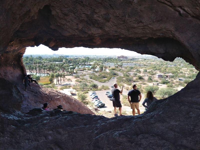
Standing at the base of Papago Park’s famous sandstone butte, it is hard to believe that just 0.2 miles and about 200 feet of elevation gain separate you from one of the most photogenic views in all of metro Phoenix.
The trail is short, well-worn, and suitable for almost any fitness level, making it a go-to for families and first-time visitors alike.
At the top, you peer through a naturally carved oval window in the rock and see the city sprawled out below you in a way that feels genuinely cinematic. March light hits the orange stone with a warmth that photographers chase all year.
Papago Park sits right between Phoenix and Tempe, so it is incredibly easy to reach from most parts of the Valley. Pack a snack, bring a camera, and plan to linger a little longer than the mileage suggests you need to.
2. Pine Creek Trail, Tonto Natural Bridge State Park
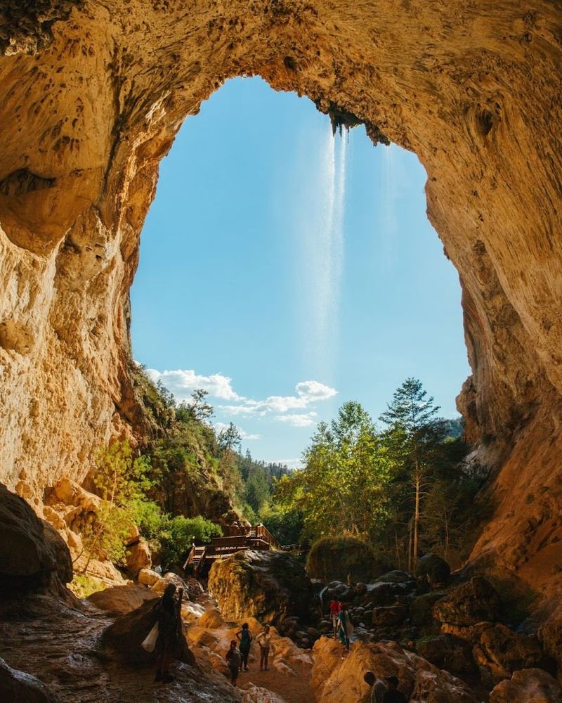
Tonto Natural Bridge State Park holds a record that most hikers do not know about: it is home to what is believed to be the largest natural travertine bridge in the world.
The Pine Creek Trail clocks in at roughly half a mile, and that short distance delivers you directly beneath this towering arch with a creek rushing underneath it.
The trail itself is steep in places and has some rocky footing, so trekking poles are a smart call. March is a particularly good time to visit because the creek runs fuller from winter moisture and the surrounding canyon walls are a rich, deep green.
If you want an even quicker fix, the Waterfall Trail inside the same park is only about 300 feet long and ends at a small waterfall cave. Either way, you are getting enormous geological drama for almost zero mileage commitment in the Payson area of central Arizona.
3. Painted Desert Rim Trail, Petrified Forest National Park
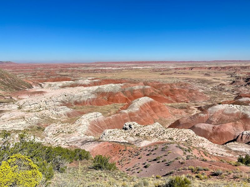
One mile round trip does not sound like much, but at Petrified Forest National Park, that single mile along the Painted Desert Rim Trail earns you views that stretch for dozens of miles across one of the most colorfully layered landscapes on the planet.
The badlands here shift through shades of lavender, coral, rust, and cream in a way that looks almost unreal.
March is a genuinely excellent month to do this hike because the crowds are lighter than summer and the cooler air makes the colors pop against a crisp blue sky. The trailhead sits near the park’s north entrance off Interstate 40 in northeastern Arizona, and the walk itself is mostly flat and easy on the legs.
Bring a wide-angle lens if you have one, because the scenery refuses to fit into a standard phone shot. This trail punches so far above its weight class it almost feels like cheating.
4. Lava Flow Trail, Sunset Crater Volcano National Monument
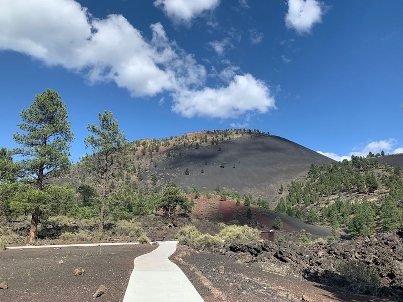
Sunset Crater Volcano National Monument sits just north of Flagstaff, and the one-mile Lava Flow Trail loop here is one of the most geologically fascinating short walks in the entire Southwest.
The trail takes you directly through the Bonito Lava Flow, a sea of jagged black basalt that erupted roughly 900 years ago and still looks fresh enough to make you feel like you just missed the show.
Interpretive signs along the route explain the volcanic forces at work, so even non-geology folks walk away with a solid appreciation for what they are seeing.
March temperatures near Flagstaff tend to be cooler than the Phoenix area, often sitting in the 50s and 60s Fahrenheit, which makes this an especially comfortable walk.
The contrast between the dark lava rock and the surrounding ponderosa pine forest creates a moody, otherworldly atmosphere that photographs beautifully. Wear sturdy shoes because the trail surface is uneven and sharp in spots.
5. Island Trail, Walnut Canyon National Monument
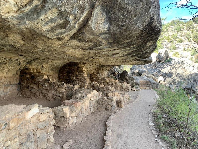
Walnut Canyon National Monument near Flagstaff holds one of Arizona’s most accessible ancient cliff dwelling experiences, and the Island Trail packs all of it into just one mile round trip.
The catch is that the trail drops about 185 feet via stone steps carved into the canyon wall, which the park classifies as strenuous despite the short distance.
That descent is absolutely worth every step. You walk past more than 25 cliff dwelling rooms built by the Sinagua people roughly 800 years ago, tucked under limestone overhangs with the canyon falling away below you.
The scale of it, combined with how close you get to the actual structures, creates a feeling that longer trails in bigger parks sometimes fail to deliver. March is a smart time to visit because the summer crowds have not arrived yet and the canyon air still carries a cool, pine-scented freshness.
The climb back out is the workout, but it is mercifully short.
6. Montezuma Castle Trail, Montezuma Castle National Monument
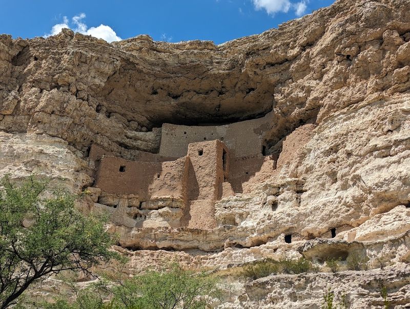
Few hikes in Arizona offer the ratio of effort to reward that Montezuma Castle delivers. The paved trail around the monument is only 0.3 miles long, shaded by enormous sycamore trees, and puts you face to face with a five-story, 20-room cliff dwelling that the Sinagua people constructed nearly a thousand years ago high in a limestone alcove.
The structure is remarkably well-preserved, and seeing it up close feels like flipping open a history book that nobody told you was this good.
The Verde Valley location, about 90 minutes north of Phoenix near Camp Verde, means March temperatures here are mild and pleasant, typically in the 60s and 70s Fahrenheit.
The trail is stroller-friendly and fully accessible, making it a rare archaeological site that truly works for every type of visitor. You will probably spend more time standing and staring up at the cliff dwelling than you actually spend walking, and that is entirely the point of coming here.
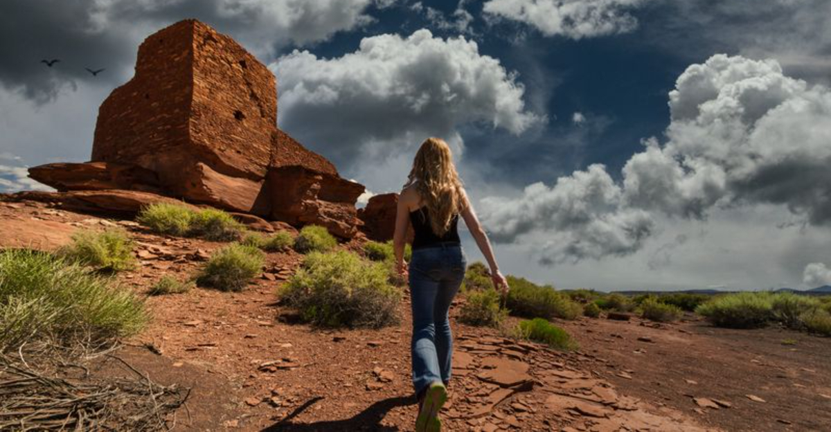
7. Wupatki Pueblo And Wukoki Pueblo, Wupatki National Monument
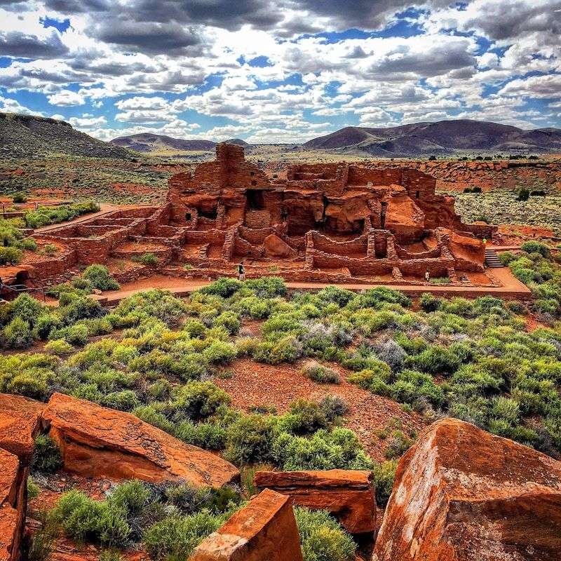
Pairing two short trails in one visit is a strategy that Wupatki National Monument practically invented. The main Wupatki Pueblo Trail runs about 0.5 miles and winds past a multi-room pueblo complex that once housed hundreds of people.
Nearby Wukoki Pueblo is only 0.2 miles round trip and delivers a dramatic standalone tower rising straight out of the red rock like a sentinel watching the desert.
Together, these two walks give you a surprisingly deep look at ancestral Puebloan culture with almost no mileage commitment. The monument sits about 30 miles north of Flagstaff off Highway 89, and the sweeping views across the painted desert from both sites are genuinely stunning on a clear March day.
March also tends to bring good light for photography here, with the low sun casting long shadows across the ancient stonework in the late afternoon. Bring water because the high desert air is dry even when temperatures feel comfortable.
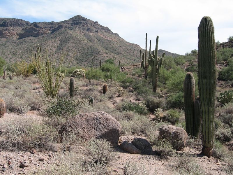
8. Desert Discovery Nature Trail, Saguaro National Park West, Tucson
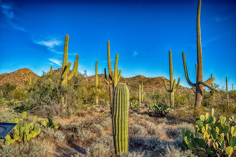
Saguaro National Park’s west district near Tucson has a trail that is basically the definition of maximum Arizona scenery for minimum effort.
The Desert Discovery Nature Trail runs between 0.4 and 0.5 miles through a forest of mature saguaro cacti, and the park specifically highlights it as a top spot for watching the sunset paint the sky behind the Tucson Mountains.
March is a wonderful month to do this walk because the desert is fully alive, temperatures in Tucson typically hover in the comfortable 70s Fahrenheit, and early spring wildflowers sometimes add unexpected splashes of color along the path. The trail is flat, paved, and fully accessible, so it works for all ages and ability levels.
There are interpretive signs throughout that explain the ecology of the Sonoran Desert in a way that actually makes you want to read them. Arrive about an hour before sunset and you will understand immediately why this trail has such a devoted following.
9. Echo Canyon Grottoes Trail, Chiricahua National Monument
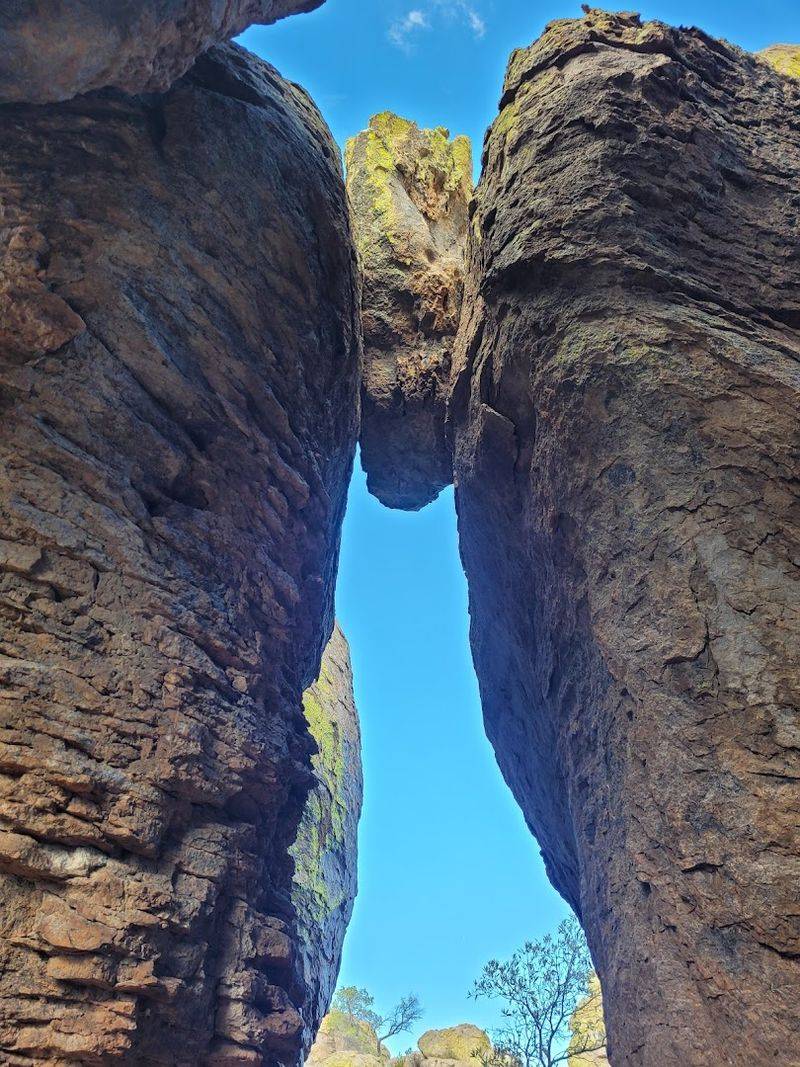
Chiricahua National Monument in southeastern Arizona is sometimes called the Land of Standing Up Rocks, and once you see it, that nickname makes complete sense.
The Echo Canyon Grottoes Trail is about one mile round trip and takes you through a surreal maze of balanced rocks, towering stone columns, and cave-like grottoes carved by millions of years of erosion.
March is actually one of the best months to visit Chiricahua because the weather is mild, the crowds are thin, and the canyon wrens are singing from every ledge. The monument sits about 120 miles southeast of Tucson near the town of Willcox, making it a solid day trip from southern Arizona.
The trail has some rocky footing and a modest elevation change, but nothing that would stop a reasonably active hiker. If you reach the grottoes and still feel energetic, the trail continues deeper into the canyon with increasingly dramatic rock formations waiting around every bend.
10. Treasure Loop Trail, Lost Dutchman State Park, Apache Junction
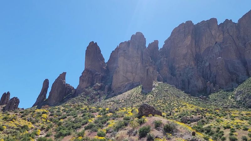
Lost Dutchman State Park near Apache Junction is named after one of Arizona’s most enduring legends, the lost gold mine supposedly hidden somewhere in the Superstition Mountains.
The Treasure Loop Trail at 2.4 miles round trip is the longest hike on this list, but it earns its place because the scenery it delivers is wildly disproportionate to the modest distance.
The trail wraps around the base of the Superstitions, giving you close-up views of those jagged volcanic ridgelines that look like they were designed specifically to be dramatic. March can bring desert wildflowers to this area depending on winter rainfall totals, and on a good year the poppies and lupine turn the hillsides into something worth driving across the state to see.
The trailhead is about 40 miles east of downtown Phoenix, making this an easy morning adventure. Start early to snag a parking spot, because word has gotten out about how good this one is.
11. Wind Cave Trail, Usery Mountain Regional Park, Mesa
Usery Mountain Regional Park sits on the eastern edge of Mesa, and the Wind Cave Trail is the park’s signature hike for good reason.
At roughly 3 miles round trip with about 800 feet of elevation gain, it is the most physically demanding trail on this list, but the payoff at the top is a natural wind cave eroded into the volcanic rock face with sweeping views of the Salt River Valley framed perfectly through the opening.
March temperatures in the East Valley are usually ideal for this kind of climb, typically in the 60s and 70s Fahrenheit, warm enough to enjoy but cool enough to push uphill without overheating. The trail surface is rocky and the final push to the cave is steep, so trail runners or sturdy hiking shoes are worth wearing.
Arrive early on weekends because this park fills up fast when the weather cooperates. The view from inside that cave looking out over the valley is the kind of thing you describe to people for weeks afterward.