This Iconic California Coastal Span Delivers One Of The Most Breathtaking Drives In The State
Some drives are roads. This one in California is a showstopper.
The kind of route where you slam the brakes just to stare, because the ocean isn’t politely waiting. It’s crashing, glowing, and claiming every cliff as its own. Each turn hits you with a new “wait, this is real?” moment.
Towering cliffs, endless blue, and that kind of wind-in-your-hair magic that makes you forget traffic exists. I didn’t just drive, I surrendered.
Every overlook pulled me out of the car, jaw slack, phone useless against the scale of it all. By the time I finally hit the end, my neck hurt, my camera was full, and my soul somehow felt bigger.
One thing was clear: I’d never settle for boring roads again.
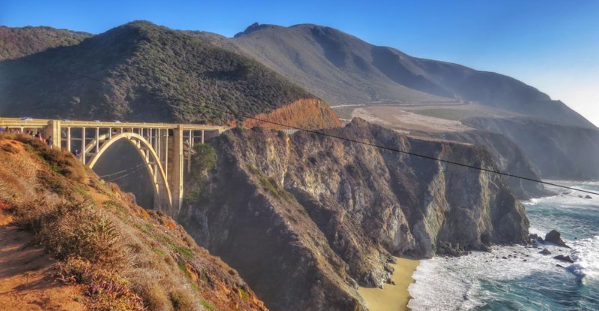
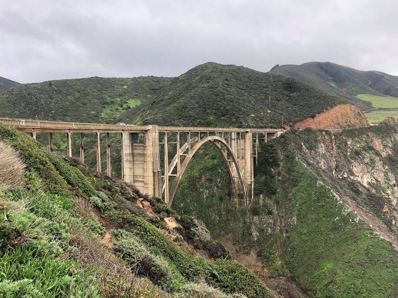
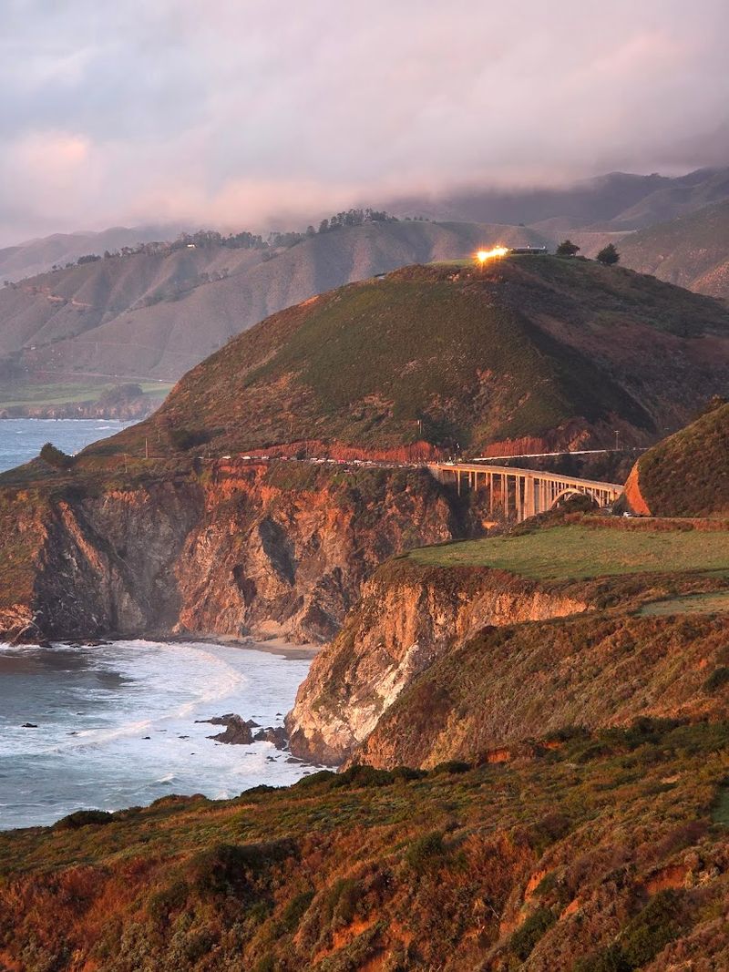
The First Glimpse Of Bixby Bridge That Stopped Me Cold
I have done plenty of road trips, but nothing matched the moment Bixby Bridge came into view around that Highway 1 curve. My foot hit the brake before my brain even processed what was happening.
I pulled off at the small overlook north of the bridge, stepped out, and just stood there like a tourist in my own life.
Completed in 1932, Bixby Creek Bridge is one of the longest single-span concrete arch bridges in the world at the time it was built. It stretches 714 feet across and sits 260 feet above Bixby Creek canyon, which drains dramatically into the Pacific Ocean below.
The engineering alone is jaw-dropping, but paired with that coastal backdrop, it becomes something almost poetic.
What really got me was how the bridge seems to belong there, like the canyon grew around it on purpose. The pale concrete arches echo the color of the coastal fog, and on the morning I arrived, wisps of mist were still curling around the base of the cliffs.
Every angle I shot looked like a magazine cover. Bixby Bridge is not just a crossing point between two stretches of highway.
It is the moment the drive becomes a memory you carry forever, and I knew immediately this trip had already paid off completely.
Pulling Over At Hurricane Point For The View
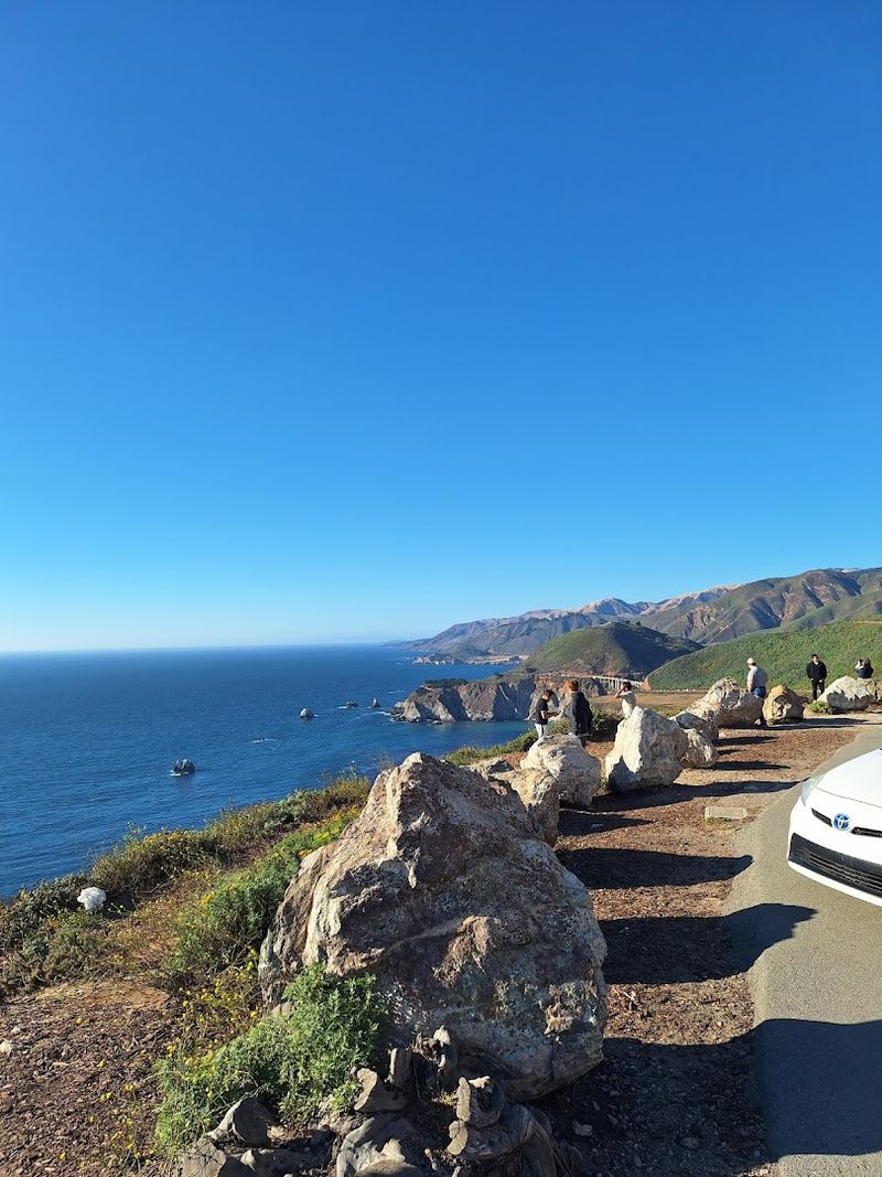
Just north of Bixby Bridge sits Hurricane Point, and let me tell you, the name is not just for dramatic effect. The wind up there hits you like the Pacific Ocean itself has decided to personally say hello.
My hair was everywhere, my jacket was flapping like a flag, and I was grinning so hard my cheeks hurt.
Hurricane Point is one of those overlooks that genuinely makes you reconsider every life choice that kept you away from California for so long.
The views stretch in both directions along the coast, revealing miles of rugged cliffs, white-capped waves, and the kind of deep blue ocean color that makes you question whether your phone screen is even calibrated correctly.
You can see Bixby Bridge from here too, tucked into the canyon below, which adds a whole new layer of perspective to the whole experience.
I spent about forty minutes at Hurricane Point just walking the edge of the pullout, taking photos from every possible angle, and eating a granola bar while the wind tried to steal it from my hand.
There are no guardrails between you and that view, which sounds scary but actually feels incredibly freeing. Standing there with the ocean roaring below and the mountains rising behind me, I felt genuinely small in the best way possible.
Some places remind you that the world is enormous and magnificent, and Hurricane Point is absolutely one of them.
McWay Falls And The Waterfall
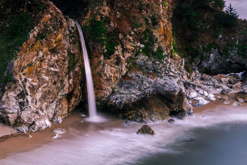
Okay, so picture a waterfall. Now picture that waterfall dropping 80 feet directly onto a pristine sandy beach while turquoise water swirls below it.
Now add dramatic coastal cliffs framing the whole scene like nature hired a set designer.
That is McWay Falls inside Julia Pfeiffer Burns State Park, and it is as ridiculously beautiful in person as it sounds right now.
I pulled into the park and took the short Overlook Trail, which is less than a mile round trip, and within about ten minutes I was standing at the viewing platform with my jaw somewhere near the ground.
The waterfall is technically a tidefall, meaning it falls directly onto the beach rather than into a river, which makes it genuinely rare and special. The cove below is completely inaccessible to visitors, which somehow makes it even more magical, like a secret the coast is keeping just for itself.
The light in the late afternoon turned the whole scene amber and golden, and the sound of the waterfall mixed with the crashing waves created this layered, hypnotic soundtrack that made me want to sit there until sunset.
McWay Falls is often called one of the most beautiful spots in all of California, and after seeing it with my own eyes, I would not argue with that claim for even a single second. It is the kind of place that makes you want to write poetry, even if you have never written a poem in your life.
Point Sur Lighthouse Standing Watch Over The Wild Coast
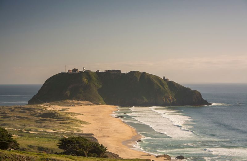
Perched on a 361-foot volcanic rock that juts out into the Pacific like a natural fortress, Point Sur Lightstation looked almost mythological when I first spotted it from the highway.
It reminded me of something out of a gothic novel, this cluster of historic stone buildings clinging to a dramatic rock surrounded on three sides by ocean, completely alone and completely magnificent.
Point Sur is the only complete 19th-century lightstation in California that is open to the public, and it has been guiding ships safely past this treacherous coastline since 1889.
The station includes the original lighthouse tower, a fog signal building, a barn, and several historic residences, all remarkably preserved.
Tours are offered on weekends and are led by volunteers from the Central Coast Lighthouse Keepers organization, and getting up close to the buildings gives you a genuine sense of what life was like for the keepers who lived here in total isolation.
From the top of the rock, the views of the Big Sur coastline are absolutely staggering. I could see the curve of the coast stretching south toward the mountains, and the waves below were crashing with a force that vibrated through the rock under my feet.
There is something deeply grounding about standing somewhere that has been a beacon of safety for over a century. Point Sur does not just offer a great view.
It hands you a piece of living California history with both hands.
Pfeiffer Beach And The Purple Sand
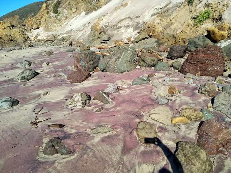
Purple sand. Let me say that again for the people in the back: purple sand.
When I turned down the narrow, unmarked road toward Pfeiffer Beach and eventually stepped onto that shoreline, I genuinely thought my eyes were playing tricks on me.
The sand had this unmistakable violet tint, like the beach was trying to be extra, and honestly, it was pulling it off beautifully.
The purple color comes from manganese garnet minerals eroding down from the bluffs above the beach, which is one of those geological facts that makes you appreciate just how wild and specific nature can be.
Pfeiffer Beach is also home to Keyhole Arch, a dramatic rock formation with a hole in the middle that frames the crashing waves perfectly.
During winter months, the setting sun aligns directly through the arch, creating what photographers call the Keyhole Arch sunset, and it is as spectacular as it sounds.
The beach itself is not a swimming beach since the waves are powerful and the currents are strong, but as a place to walk, explore, and completely lose track of time, it is extraordinary.
I sat on a driftwood log for a solid hour watching the waves push through the arch and listening to the sound of the ocean doing its thing without any interference. The access road is intentionally tricky to find, which keeps the crowds manageable and makes discovering it feel like a genuine reward.
Pfeiffer Beach earns every bit of its cult status.
Andrew Molera State Park
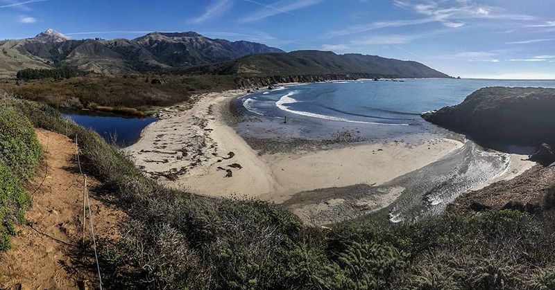
After spending so much time in the car, even a car on one of the most beautiful roads in the world, my legs were ready to stretch out and actually touch the ground. Andrew Molera State Park was exactly the answer I needed.
It is the largest state park in Big Sur, covering over 4,800 acres of coastal land where the Big Sur River meets the Pacific, and it felt like stepping into a completely different version of the same incredible landscape.
The park has a network of trails ranging from easy beach walks to more challenging ridge routes with sweeping coastal views.
I took the Beach Trail, which winds through meadows of golden grass before opening up to a wide, wild stretch of beach at the river mouth. The waves here are big and powerful, and the beach is wide and pebbly, the kind of spot where you feel the full force of the open Pacific without anything softening the experience.
What surprised me most was how quiet it was compared to the roadside stops. The further I walked from the parking area, the more the crowds thinned out until it was just me, the wind, the river, and the mountains rising dramatically behind the tree line.
I found a flat rock near the water and ate my lunch watching pelicans glide low over the surf in perfect formation. Andrew Molera reminded me that Big Sur is not just meant to be seen through a windshield.
Sometimes you have to actually walk into it.
The Drive South Toward Hearst Castle
Here is the thing nobody tells you before you drive Big Sur: the road itself is the destination. Not just the stops, not just the viewpoints, but the actual act of moving through this landscape at whatever speed the curves demand.
By the time I was heading south toward San Simeon and the legendary Hearst Castle, I had completely abandoned any pretense of being on a schedule.
The southern stretch of Highway 1 through Big Sur offers a slightly different character than the northern section. The cliffs here feel even more exposed, the ocean even more vast, and the road gets wonderfully twisty in a way that demands your full attention and rewards it generously.
Elephant Seal Vista Point near San Simeon is one of the most unexpectedly entertaining stops along the route, where hundreds of enormous elephant seals pile onto the beach below the highway in a spectacular, chaotic display of marine life doing exactly what it wants.
Hearst Castle sits just inland from here, perched on the hill that newspaper magnate William Randolph Hearst called La Cuesta Encantada, which translates to The Enchanted Hill, and the name feels earned when you see it glittering above the coast.
The whole southern run of this drive layered experience on top of experience until I felt genuinely overwhelmed by how much California had packed into a single stretch of road.
If you ever find yourself on Highway 1 through Big Sur, promise yourself one thing: leave the clock at home, because this drive deserves every single minute you can give it.