These Arizona Trails Somehow Stay Off Tourist Radars And That Is A Shame
Arizona has a way of stealing the spotlight with its most famous scenery, but some of its best trails quietly wait for hikers who are willing to look a little harder.
I’m currently standing on the edge of a canyon that looks like it was painted by a creator with a serious flair for the dramatic, and guess what? There isn’t a single rental car in sight.
No discarded plastic bottles, no shouting crowds, just the wind and my own frantic heartbeat. It makes me want to scream from the highest peak, yet a small part of me wants to bury the map in the sand forever.
We spend so much time chasing the “top ten” lists on social media that we miss the actual masterpieces hiding in plain sight.
These Arizona trails somehow stay off tourist radars and that is a shame for every adventurer looking for a soul-stirring escape. I’m finally breaking my vow of silence because you deserves to see the desert’s true face.
1. Nature Trail Loop, Oracle State Park
Spring arrives early at Oracle State Park, and the Nature Trail Loop is one of the first places in Arizona where you can feel it underfoot.
This 1.2-mile path winds through rolling terrain with views stretching across the San Pedro River Valley and the Galiuro Mountains, which look almost painted against the sky on clear mornings.
Wildflowers push up along the edges of the trail each spring, turning what could be a simple walk into something genuinely memorable.
The trail also passes a wildlife blind positioned near a waterhole, making it a surprisingly productive spot for birdwatching. Deer, javelinas, and a wide range of bird species visit regularly. Oracle State Park sits about 75 miles north of Tucson, making it an easy day trip that most visitors completely skip in favor of busier destinations nearby.
Honestly, the crowd-free atmosphere alone makes this loop worth the drive.
2. Foothills Loop Trail, Kartchner Caverns State Park
Most people who visit Kartchner Caverns spend their entire trip underground, which means the Foothills Loop Trail sits almost completely empty on any given day.
That is their loss and your opportunity. The 2.5-mile moderate-to-difficult route climbs through classic Sonoran Desert terrain, and a scenic viewpoint spur rewards the extra effort with broad, sweeping Whetstone-area panoramas that feel far bigger than the distance you walked to earn them.
Riparian sections add variety along the way, with shaded stretches and plant communities that contrast nicely with the open rocky slopes.
The trail is located near Benson in southeastern Arizona, about 45 miles east of Tucson. It is well-maintained and clearly marked, so navigation stays straightforward even for hikers visiting the area for the first time.
Pair the loop with a cave tour and you have one of the most complete half-day adventures in the entire state, no crowds required.
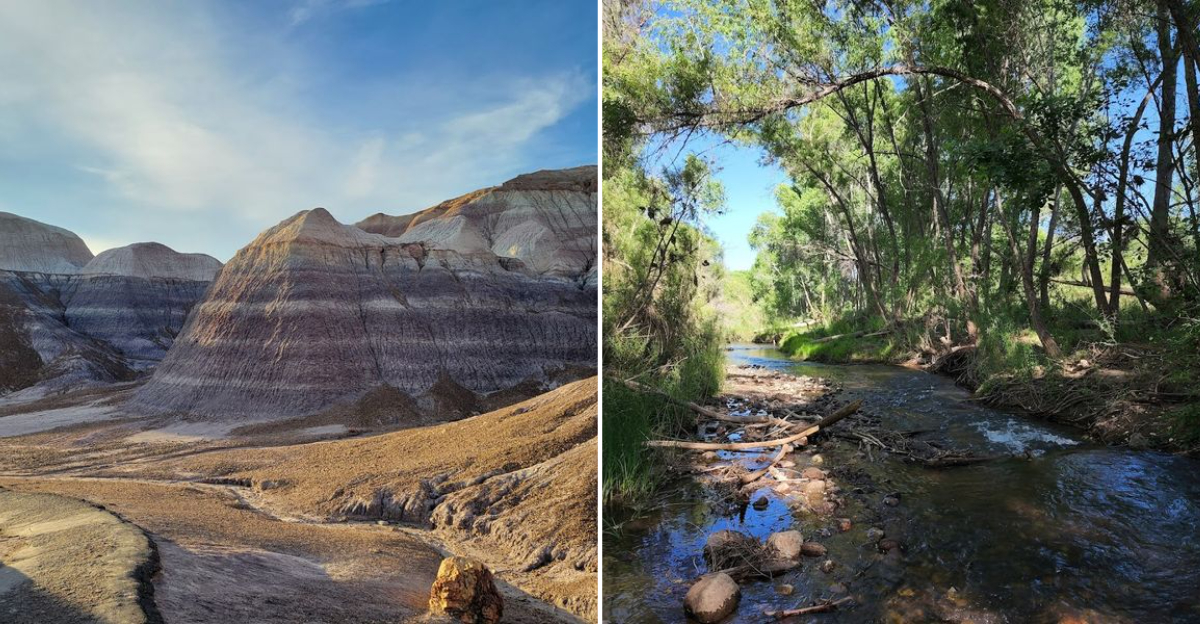
3. Lime Kiln And Raptor Trails, Dead Horse Ranch State Park
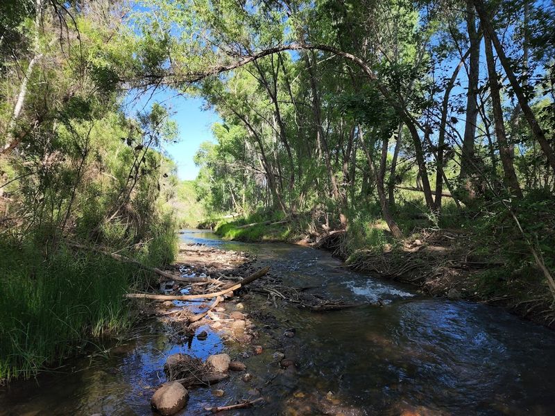
Dead Horse Ranch State Park near Cottonwood, Arizona, has a trail network stretching over 20 miles, and almost nobody outside the local community seems to know it exists.
The park gets a fraction of the attention that nearby Sedona pulls in, even though its riparian forests along the Verde River are genuinely beautiful in a quieter, more understated way.
The recommended counterclockwise basic loop using the Lime Kiln and Raptor Trails is the best introduction to what the park offers.
Birding along this route is exceptional, particularly during migration season when the cottonwood groves fill with warblers and other songbirds passing through the Verde Valley corridor.
Cyclists and equestrians share portions of the trail system, giving the whole place a relaxed, community park energy that feels refreshing after busier Arizona destinations. Pack a lunch, take your time, and let the Verde River views do exactly what good trail scenery should do: make you forget about your schedule entirely.
4. Gowan Trail, Tonto Natural Bridge State Park
Tonto Natural Bridge is famous enough that plenty of people have heard of it, but here is what most visitors actually do: they walk to the viewpoints, take a photo of the world’s largest natural travertine bridge from above, and leave. The Gowan Trail takes you somewhere much better.
This rough, steep down-and-back route drops directly into the creek bottom and delivers you to an observation deck positioned right at the base of the bridge, where the scale of the formation becomes genuinely jaw-dropping.
The trail requires careful footing because the descent is legitimately steep and the rocks can be slippery near water. The park is located near Payson in central Arizona, roughly 90 miles northeast of Phoenix.
Check posted closing times before you start because the trail operates within specific hours. Few short hikes in Arizona reward the effort as immediately or as dramatically as Gowan Trail does when that bridge finally fills your entire view.
5. Ridge Trail, Pipe Spring National Monument
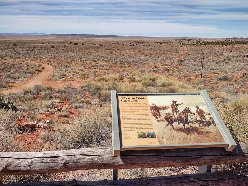
Half a mile might sound too short to bother with, but the Ridge Trail at Pipe Spring National Monument earns its place on this list through sheer scenic payoff and storytelling.
The path climbs from the monument grounds to a line of low cliffs that open up sweeping views across the Arizona Strip, a remote high-desert plateau that most Arizonans themselves rarely visit.
Interpretive stops along the way connect the landscape to both human history and natural history in ways that feel genuinely engaging rather than dry.
Pipe Spring National Monument sits near Fredonia in northern Arizona, close to the Utah border and the North Rim of the Grand Canyon. The historic fort at the monument adds historical context that makes the short walk feel like a full experience rather than a quick stretch.
The isolation of the Arizona Strip gives the trail an atmosphere that bigger, busier parks simply cannot replicate. Short trails can carry big impressions, and this one proves it.
6. Coronado Peak Trail, Coronado National Memorial
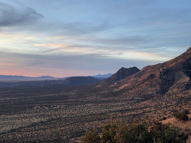
The name sounds modest, but arriving at the top of Coronado Peak delivers one of the more dramatic views available on a maintained trail anywhere in southern Arizona. The interpretive route climbs from Montezuma Pass to the summit, where the landscape opens across two countries simultaneously.
The San Pedro Valley stretches north into Arizona while the San Rafael Valley and the Mexican state of Sonora fill the southern horizon, creating a view that feels genuinely historic given the trail’s connection to Spanish exploration.
Coronado National Memorial is located near Sierra Vista in Cochise County, southeastern Arizona, right along the international border. The drive up to Montezuma Pass alone is worth the trip, and the trail from there adds meaningful context to everything you can see from the top.
Interpretive signs along the route explain the 1540 Coronado expedition without turning the walk into a lecture. Standing at the peak and looking into two countries at once is a moment that quietly sticks with you.
7. Joe’s Canyon Trail And Yaqui Ridge Trail, Coronado National Memorial
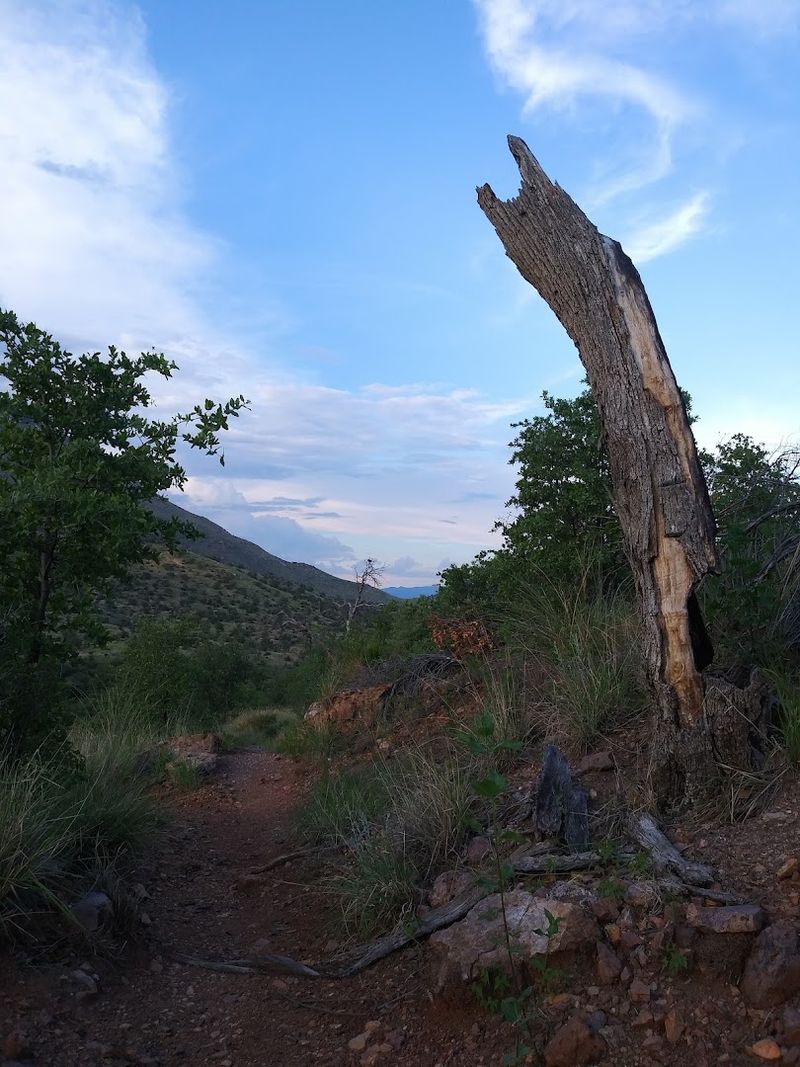
For hikers who want something more physically demanding than the Coronado Peak interpretive walk, this trail combination at Coronado National Memorial is the answer.
Joe’s Canyon climbs steeply and quickly from the trailhead, rewarding the effort with views down into Montezuma Canyon and across the San Pedro River Valley that feel earned rather than handed to you.
The terrain is rugged in the best possible sense, with rocky footing and open exposure that keeps the experience honest.
The Yaqui Ridge spur extends to the international border and marks the southern terminus of the Arizona National Scenic Trail, which is a genuinely meaningful detail for long-distance hiking enthusiasts. The memorial sits near Sierra Vista, and the combination of both trails makes for a satisfying half-day outing with real elevation and real views.
Bring plenty of water because shade is limited on the upper sections of both routes. This combo quietly delivers one of the most layered hiking experiences in all of southeastern Arizona.
8. Montezuma Well Trails, Montezuma Castle National Monument
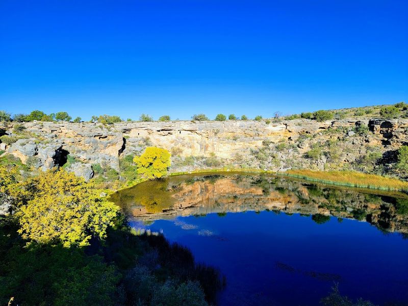
Montezuma Castle gets the crowds and the magazine covers, but the Montezuma Well section of the same national monument sits a few miles away and offers something quieter, older-feeling, and arguably more interesting.
The short trails here wind through a sacred oasis landscape built around a natural limestone sink that holds water year-round in the middle of the high desert. Shaded forest near the swallet and outlet creates a microclimate that feels startlingly cool and green compared to the surrounding terrain.
Indigenous peoples used this water source for over a thousand years, and the sense of layered human history here runs deep even on a quick walk. The monument is located near Camp Verde in central Arizona, about 90 miles north of Phoenix.
The trails are short enough for families with young children but interesting enough that adults rarely feel like they are rushing through. Montezuma Well is the kind of place that rewards slow walkers and curious minds in equal measure.
9. Lomaki And Box Canyon Pueblos Trail, Wupatki National Monument
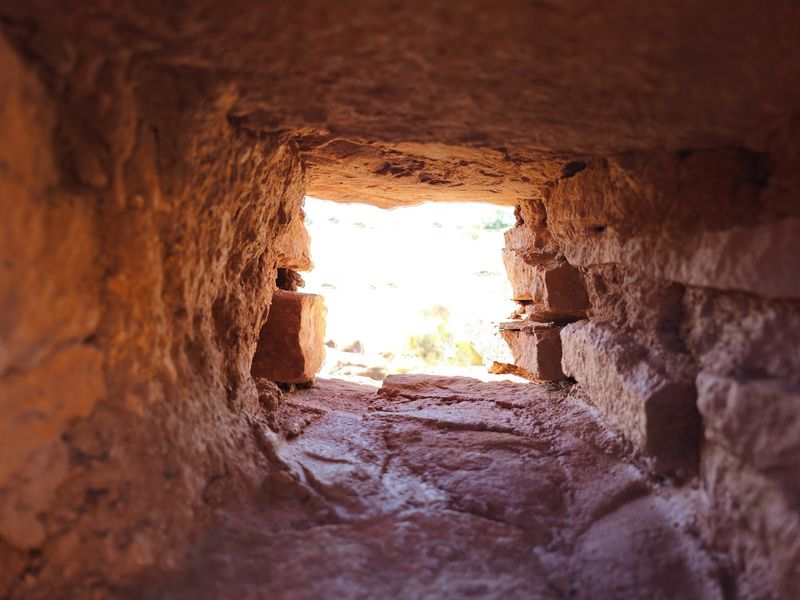
Wupatki National Monument draws visitors to its main pueblo, and most people consider that the main event before moving on to nearby Sunset Crater. The Lomaki and Box Canyon Pueblos Trail quietly offers something those visitors miss entirely.
The path leads to Lomaki, whose name translates to Beautiful House, a fitting description for a well-preserved ancestral pueblo perched at the edge of a shallow canyon. Box Canyon ruins nearby add a second site that makes the walk feel like a genuine archaeological exploration rather than a quick stop.
The trail is open from sunrise to sunset year-round, and the northern Arizona high desert setting near Flagstaff gives it a wide-sky atmosphere that feels expansive in every direction. Morning light on the red rock ruins is particularly striking for photography.
The relative quiet here compared to the main Wupatki Pueblo area makes it easy to spend time actually absorbing the history rather than navigating around other visitors. Beautiful House earned its name, and walking to it feels like a small, satisfying discovery every single time.
10. Citadel And Nalakihu Pueblos Trail, Wupatki National Monument
Perched on a volcanic rise that gives it a commanding presence over the surrounding desert, the Citadel Pueblo at Wupatki National Monument looks exactly like something that should be on every Arizona itinerary but somehow rarely is.
The trail connecting the Citadel with nearby Nalakihu Pueblo is open sunrise to sunset year-round and delivers elevated ruins alongside desert views that feel wilder and more expansive than most visitors expect from a national monument stop.
The Painted Desert stretches out to the east in a color palette that changes noticeably throughout the day.
Nalakihu, which means House Standing Outside the Village, sits at the base of the same rise and provides a contrasting architectural scale to the hilltop Citadel. Both sites are remarkably well-preserved and easy to explore without any technical hiking skills required.
Wupatki National Monument is located about 35 miles north of Flagstaff along U.S. Highway 89. The views from the Citadel alone are worth stopping the car and lacing up your shoes.
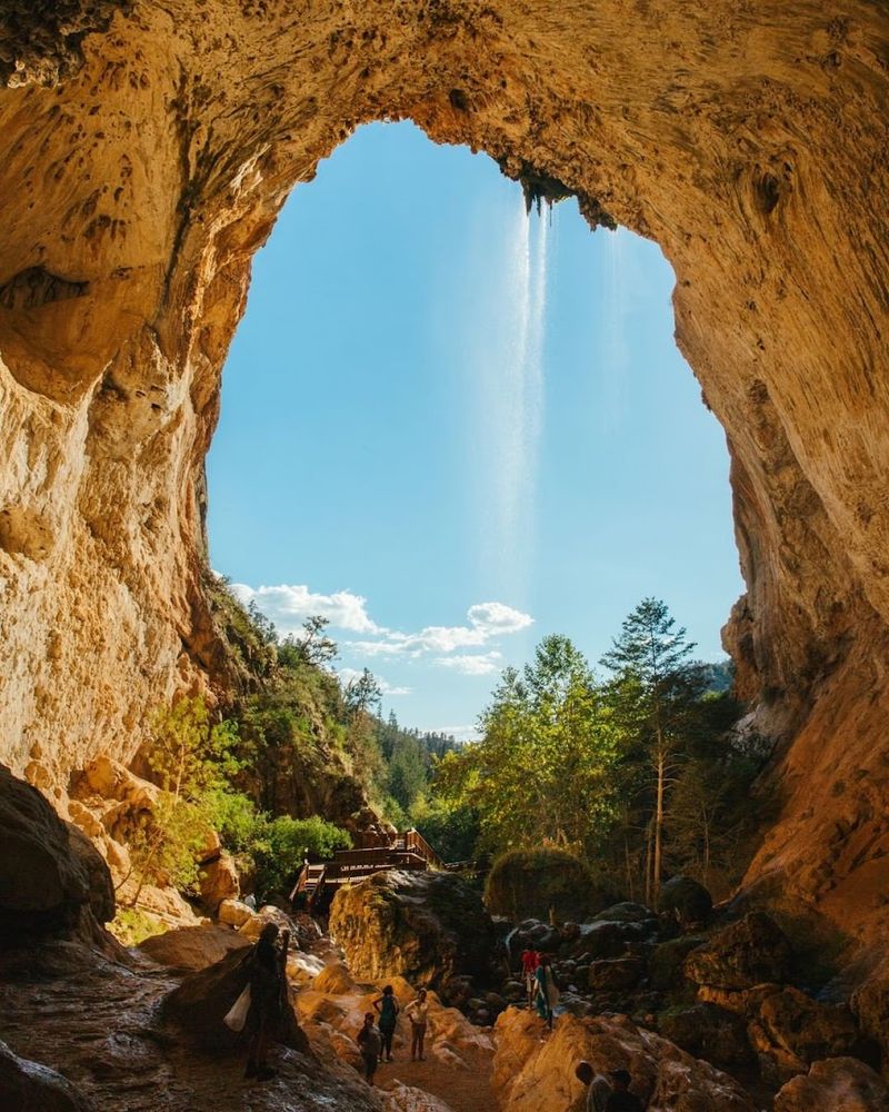
11. White House Trail, Canyon De Chelly National Monument
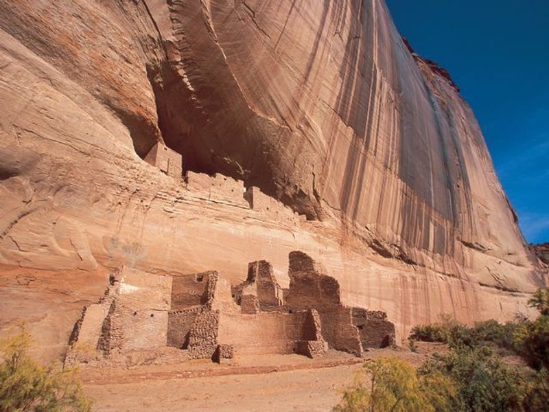
Canyon de Chelly is one of the most visually powerful places in the American Southwest, and the White House Trail is the only public route in the entire park that hikers can walk without a permit or a Navajo guide.
That fact alone should make it famous, yet it remains far less discussed than comparable canyon hikes elsewhere in Arizona and Utah.
The trail is 2.5 miles round trip, drops 600 feet from the canyon rim to the creek bottom, and ends at an observation area facing the White House Ruin, an ancient cliff dwelling tucked into a dramatic alcove.
Canyon de Chelly National Monument is located near Chinle in the Navajo Nation of northeastern Arizona. The descent through layered red sandstone walls is one of the most visually rewarding experiences a day hiker can have in this state.
The trail is confirmed open in 2026, making now a great time to plan a visit before word gets out any further. Walking into this canyon changes your sense of scale in ways that are hard to put into words afterward.
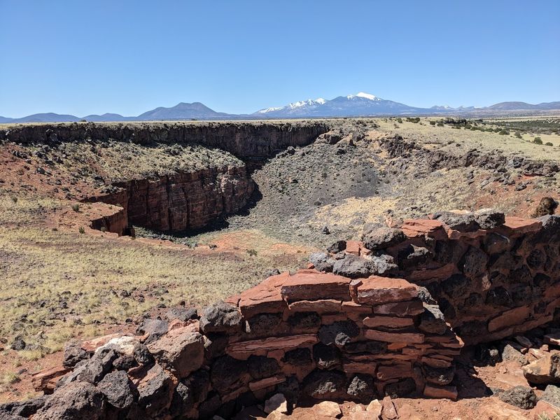
12. Blue Mesa Trail, Petrified Forest National Park
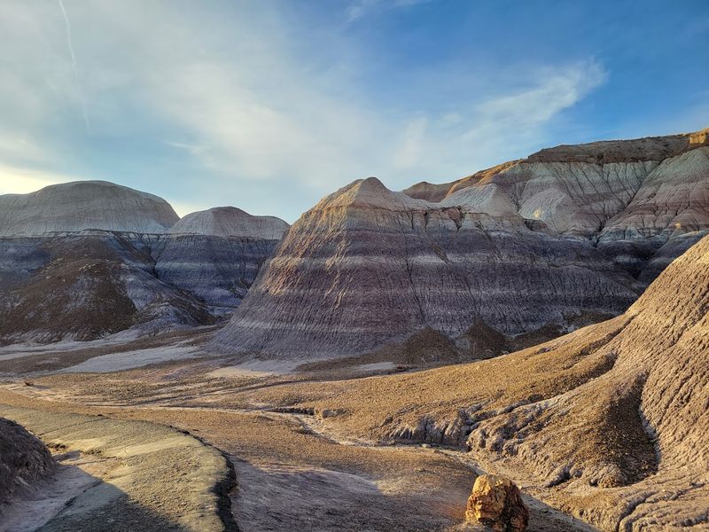
There is something almost surreal about walking down into Blue Mesa, where the ground shifts from ordinary desert scrub into a landscape of layered blue, purple, and gray bentonite badlands studded with chunks of ancient petrified wood.
Petrified Forest National Park gets a steady stream of visitors along its main scenic drive, but many of them see Blue Mesa only through a car window before rolling on to the next overlook.
The 1-mile loop trail actually takes you down into that landscape, which is a completely different experience from viewing it from above.
The trail descends into the badlands and winds among formations that look like something from another planet, particularly in the soft light of early morning or late afternoon. Petrified Forest National Park is located in northeastern Arizona along Interstate 40 near Holbrook.
The loop is short enough to complete in under an hour but distinctive enough to remember for years. Blue Mesa is the kind of hike that photographs beautifully but feels even better in person.