11 Strange Geological Spots Hidden Around Illinois
Illinois probably isn’t the first place you think of for wild, jaw-dropping geology, but it has a way of sneaking up on you.
Beneath the farmland and familiar landscapes, there are ancient fossil beds, strange rock formations, and traces of glaciers that shaped more of the state than most people realize.
I have spent years chasing down offbeat places around the country, and I keep coming back to Illinois because it always has something new to show me.
This list rounds up unusual geological spots scattered around the state, each with its own weird, fascinating story that actually feels even better when you see it in person.
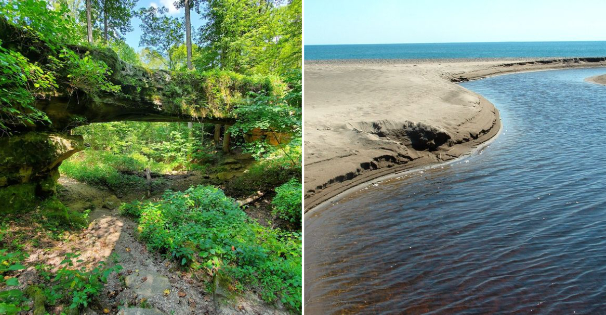
1. Pomona Natural Bridge
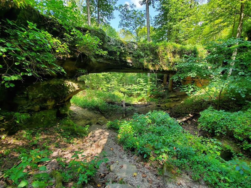
Few things in the natural world stop you cold the way a massive sandstone arch rising out of a quiet forest does. Pomona Natural Bridge, located in the Shawnee National Forest near the small community of Pomona in Jackson County, southern Illinois, is exactly that kind of place.
The arch spans roughly 90 feet and stands about 25 feet high, making it one of the largest natural sandstone bridges in the entire eastern United States.
Geologists believe the formation dates back hundreds of millions of years, shaped by the slow erosion of ancient sandstone layers carved by water over unimaginable stretches of time.
The trail leading to the bridge is short and manageable, running less than a mile round trip, so even casual hikers can reach it without breaking much of a sweat. Tall oaks and hickories frame the arch beautifully, especially in autumn when the leaves turn gold and rust.
Spring visits offer lush greenery and occasional wildflowers along the path. There is no admission fee, and parking is simple and accessible right off the forest road.
Pack a lunch and plan to sit quietly beneath the arch for a while, because the silence here is genuinely restorative.
2. Obama Kissing Rock
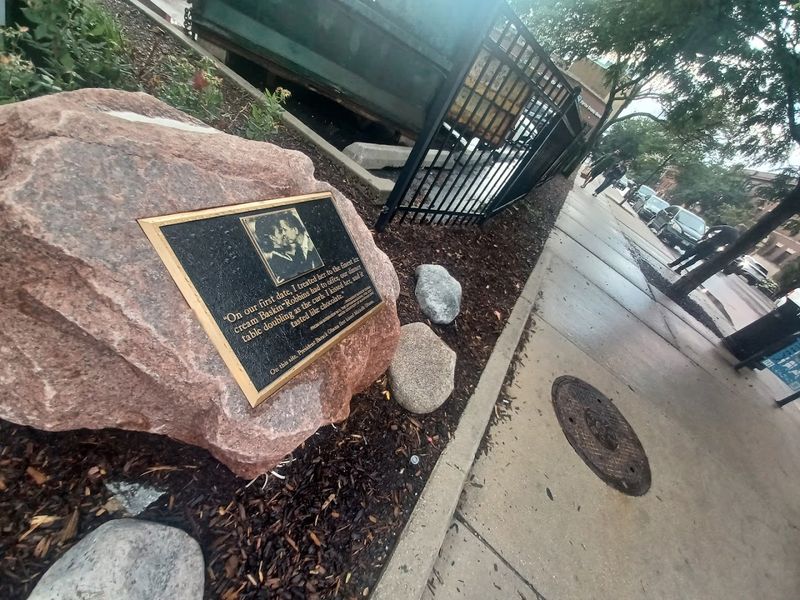
There is a small commemorative boulder in the Hyde Park neighborhood of Chicago that marks the site of Barack and Michelle Obama’s first kiss.
The site, often called Obama Kissing Rock, is a modern landmark tied to presidential history rather than a long-standing local folklore tradition. The rock itself is a large glacial erratic, a boulder transported far from its original location by the movement of ancient glaciers during the last Ice Age.
Glacial erratics are fascinating geological storytellers. They carry clues about where ice sheets traveled and how far they pushed rock material across the landscape thousands of years ago.
This particular boulder is composed of a rock type that does not match the local bedrock, which is what makes it a genuine erratic rather than a naturally occurring local formation.
Hyde Park sits on Chicago’s South Side, making this an easy stop while exploring the city. The surrounding area also features the massive Thornton Quarry nearby, one of the largest aggregate quarries in the world.
Visiting both in the same afternoon gives you an unexpectedly complete picture of just how geologically rich this part of the state actually is.
3. Ulysses S. Grant Boulder
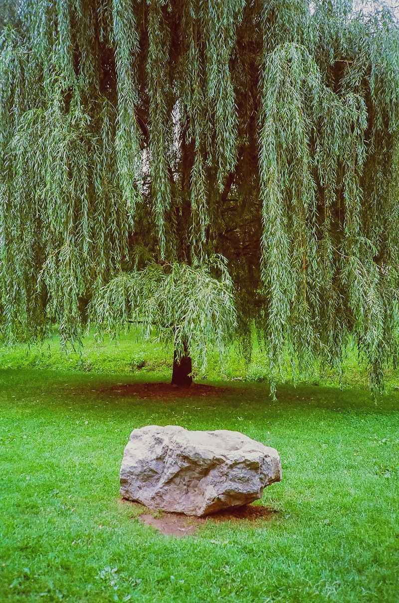
Out in the open green space of Washington Park, the Ulysses S. Grant Boulder is easy to miss if you are not looking for it, but it is worth slowing down when you find it.
At first glance, it is just a large, weathered stone sitting quietly in the grass.
But that rock has a much longer story behind it than the city surrounding it. It is a glacial erratic, carried here thousands of years ago by massive ice sheets during the last Ice Age and left behind as they melted and pulled back across northern Illinois.
Standing next to it, you are looking at something that traveled across the landscape long before Chicago existed. Over time, the boulder picked up a second layer of meaning as a historical marker connected to Ulysses S.
Grant.
That mix of deep-time geology and human history gives it a quiet kind of presence. It is not a dramatic stop, but it is the kind of place that makes you pause for a minute and think about how much history can be sitting right in front of you.
4. Rockmen Guardians
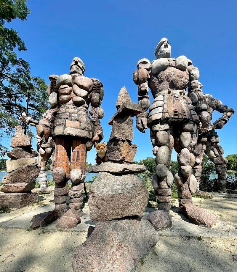
In Rockford, Illinois, a series of large stone sculptures known as the Rockmen Guardians stand along the Rock River as a striking example of public art.
These humanoid rock formations have drawn curious visitors for years, sparking debate about whether they are purely natural erosion features or the product of human hands shaping the local sandstone into watchful figures.
The Shawnee Hills region of southern Illinois is already packed with unusual rock formations, carved arches, and dramatic outcroppings shaped by millions of years of geological activity.
Sandstone in this area erodes in unpredictable and visually striking ways, producing shapes that easily fire the human imagination. Whether the Rockmen are entirely natural or partially shaped, they fit perfectly into a landscape that already feels slightly otherworldly.
Visiting this area requires a bit of hiking and a willingness to explore off the main trail. Comfortable footwear and a good trail map are genuinely helpful here.
The best light for photography falls in the late afternoon when warm golden tones hit the sandstone surfaces and cast dramatic shadows that make the Guardians look even more alive and watchful than they already do.
5. Dead River
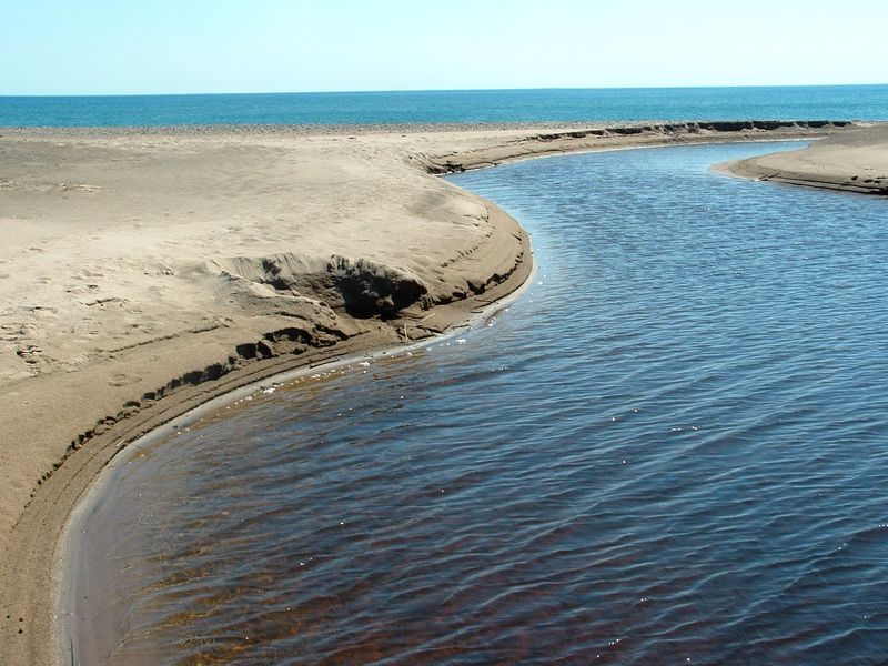
A river that seemingly goes nowhere sounds like something out of a geography riddle, but the Dead River near Chicago in Cook County is a real and genuinely fascinating hydrological oddity.
This short, unusual waterway runs parallel to Lake Michigan for a stretch before its outlet is blocked by a sandbar, leaving it trapped and unable to drain freely into the lake. The result is a slow, brackish channel that sits quietly behind the beach, cut off from the open water just a few hundred feet away.
From a geological standpoint, the Dead River is a classic example of a bar-built estuary, a feature formed when longshore drift deposits sediment across the mouth of a waterway.
The sandbar that blocks it shifts with storms and seasonal lake conditions, occasionally allowing the river to breach through before closing again. It is a dynamic system that changes year to year in small but meaningful ways.
The Dead River sits within Illinois Beach State Park near Zion in Lake County, which is itself a remarkable landscape of sand dunes, wetlands, and shoreline habitats.
Birdwatchers love this park, and the combination of geological interest and wildlife viewing makes it one of the more rewarding natural areas in the Chicago metropolitan region. Early morning visits are particularly peaceful here.
6. Devil’s Standtable Nature Trail
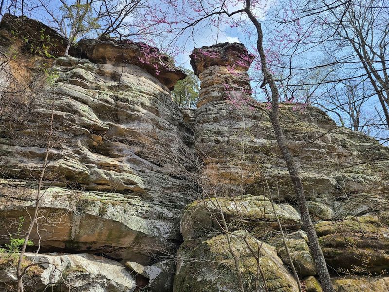
The name alone is enough to make you want to pack your hiking boots immediately. Devil’s Standtable is a striking sandstone formation located along a short trail in Giant City State Park near Makanda in southern Illinois.
The feature is essentially a large, flat-capped rock pillar that rises from the forest floor, shaped over millions of years by differential erosion of the local sandstone and shale layers.
Differential erosion happens when harder rock resists weathering while softer surrounding material wears away, leaving the resistant cap perched on a narrowing pedestal of stone.
The result looks almost architectural, as if something or someone deliberately balanced a broad flat slab on top of a tapered column. This type of formation is relatively rare in Illinois, making Devil’s Standtable a genuine geological highlight of the region.
The trail system around this feature winds through mature hardwood forest and passes several other interesting rock outcroppings along the way. Wear sturdy shoes because the terrain involves some uneven rocky sections.
Jackson and Union counties in southern Illinois are the correct area to target for this hike, and nearby Shawnee National Forest destinations can easily be combined into a full day of exploration.
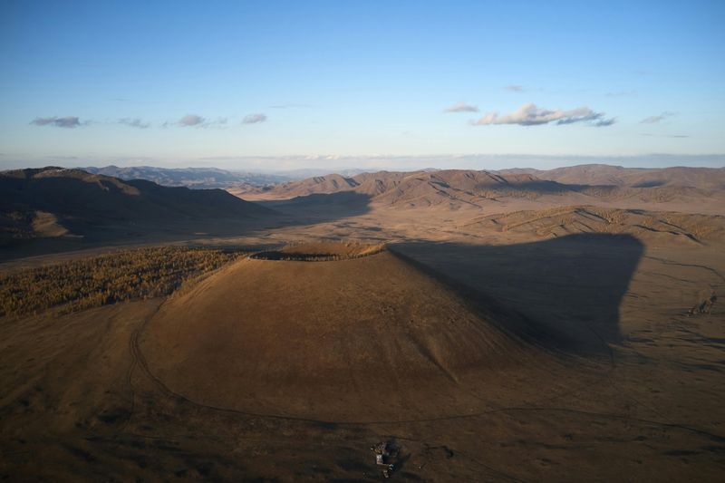
7. Camelback Kame
Not every geological wonder announces itself with dramatic cliffs or roaring water. Sometimes a gently rounded hill rising above a flat farm field is the most interesting thing in the county, and that is exactly the case with Camelback Kame in northeastern Illinois.
A kame is a rounded, steep-sided hill formed from sediment deposited by meltwater flowing into or onto a glacier during the Ice Age, and this particular example has a distinctive double-humped profile that gives it its memorable name.
Kames are scattered across northern Illinois wherever glaciers once sat and melted, but finding one as visually clear and well-preserved as Camelback Kame is genuinely uncommon.
The shape tells a detailed story about how meltwater pooled and deposited gravel and sand in a specific location as the ice retreated roughly 12,000 to 15,000 years ago. Standing next to it and knowing that history makes the view surprisingly moving.
The surrounding landscape of McHenry County is mostly agricultural, which actually helps the kame stand out even more dramatically against the flat fields around it. This is a good spot for geology enthusiasts who appreciate subtler landforms rather than sheer cliffs or arches.
Bring a field guide to glacial landforms and you will find yourself reading the entire landscape around you in a completely new way.
8. Mazon Creek Fossil Beds
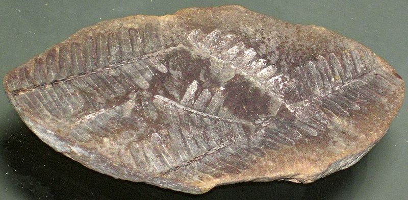
Cracking open a rock and finding a 300-million-year-old creature inside it sounds like something reserved for professional paleontologists, but at the Mazon Creek Fossil Beds in Grundy County, Illinois, everyday visitors have been doing exactly that for generations.
This site is internationally famous among fossil hunters because the concretions found here, known as Mazon Creek nodules, contain exceptionally well-preserved specimens from the Pennsylvanian Period, roughly 307 million years ago.
The fossils found here include not just hard-shelled creatures but also soft-bodied organisms that rarely survive the fossilization process, making Mazon Creek scientifically extraordinary.
Jellyfish, worms, shrimp-like creatures, and even a bizarre eel-like animal called Tullimonstrum gregarium, or the Tully Monster, have been pulled from these rocks. The Tully Monster is so unique that it was named the official State Fossil of Illinois.
The main public access area is in the Mazonia-Braidwood State Fish and Wildlife Area near Braidwood, where visitors can legally collect fossils from designated locations.
Bring a rock hammer, safety glasses, and a bucket, and plan to spend several hours searching through the gray shale nodules along the creek banks. Few geological experiences in the Midwest offer this level of hands-on wonder.
9. Hicks Dome
Hidden beneath the forests of Hardin County in far southern Illinois lies one of the most geologically unusual features in the entire state.
Hicks Dome is a circular uplift structure roughly five miles in diameter, caused by a violent upwelling of deep underground gases and fluids that pushed the overlying rock layers upward millions of years ago. Geologists classify it as a cryptoexplosion structure, meaning its origin involves explosive subsurface forces rather than surface erosion or glacial activity.
What makes Hicks Dome especially fascinating is its association with rare minerals and unusual rock types not commonly found elsewhere in Illinois.
Fluorite, which was once mined extensively in this part of the state, occurs here alongside other minerals that hint at the intense geological activity that shaped the dome. Illinois was once the leading producer of fluorite in the United States, and the Hicks Dome region played a role in that history.
The feature is not visually dramatic from the ground since the uplift is subtle and the forest covers most of it. But knowing what lies beneath the surface as you walk through the quiet Shawnee Hills makes the experience feel like reading a secret written in stone.
Geology maps and topographic tools help reveal the dome’s circular structure when viewed from above.
10. Bork’s Falls
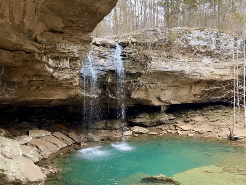
Waterfalls in Illinois are rarer than you might expect, which is exactly what makes Bork’s Falls in Ferne Clyffe State Park in Johnson County such a worthwhile destination.
This modest but genuinely pretty waterfall drops over a series of dolomite ledges in a quiet wooded ravine, creating the kind of scene that feels almost out of place in a state better known for flat farmland than cascading water.
The falls flow best in spring after snowmelt and rain, when the water volume is highest and most photogenic.
The dolomite rock exposed at Bork’s Falls dates back to the Silurian Period, roughly 440 million years ago, when a shallow tropical sea covered what is now northern Illinois.
The layered, ledge-like structure of the rock is a direct result of how carbonate sediments accumulated in that ancient marine environment, layer by layer, over millions of years. Erosion by the stream has cut down through those layers to reveal the geology in a beautifully accessible way.
The falls are located within a natural area in McHenry County that requires a short walk through woodland to reach. The trail is informal but not difficult.
Visiting in early spring gives you both peak water flow and the bonus of emerging wildflowers along the ravine edges, making the whole walk feel like a quiet reward for those willing to seek it out.
11. The Stoneface Trail
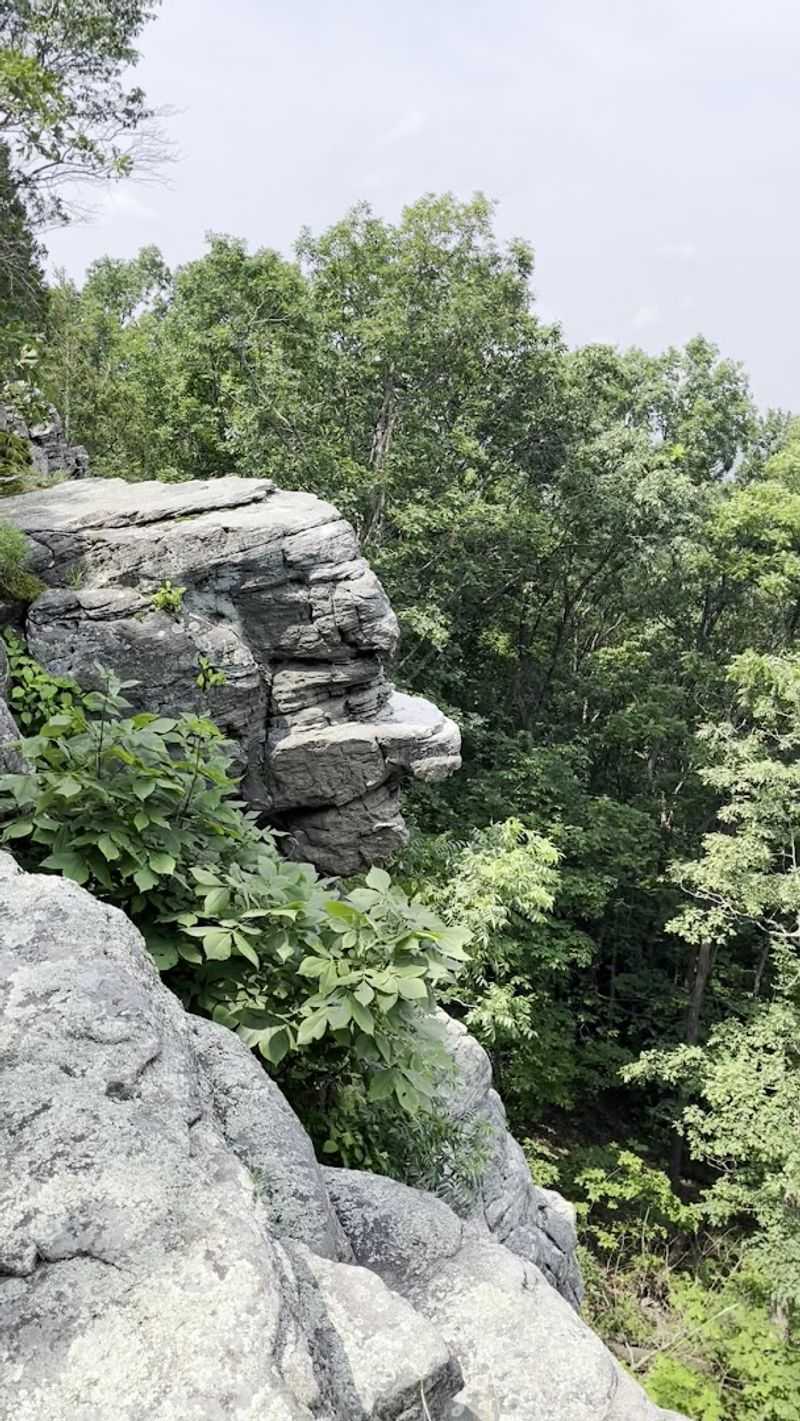
Rock formations that look like faces have a way of making you stop walking and just stare for awhile.
The Stoneface area in Saline County, southern Illinois, takes its name from formations where centuries of weathering and erosion have sculpted the local sandstone into shapes that resemble human profiles and expressions.
The trail winds through the Shawnee National Forest and passes some of the most visually striking rock outcroppings in the entire state.
The sandstone in this part of Illinois was deposited during the Pennsylvanian Period and has been slowly shaped by water, wind, and frost action ever since.
The result is a landscape full of overhangs, crevices, rounded boulders, and vertical walls decorated with lichens and mosses that add color and texture to the already dramatic scenery. The face-like formations are concentrated in specific sections of the trail where erosion has worked particularly creatively on the stone.
Plan for a moderate hike of a few miles with some uneven footing along rocky sections. The trail rewards patient walkers who take time to study each formation rather than rushing past.
Fall is arguably the best season to visit, when the surrounding hardwood canopy blazes with color and the warm tones of the leaves perfectly complement the honey-colored sandstone of the Stoneface Trail.