Stand In Three States At Once On This Unique Arkansas Road Trip
It looks like an ordinary stretch of road through the Ozarks. Nothing flashy. No crowds. Then you pull over, take a few steps, and everything changes.
One foot lands in a different state. Shift again, and you are in another.
Just like that. It feels a little unreal, like you are playing with the map instead of just driving through it.
People start laughing, testing it, snapping photos to prove it actually works. It is quick, simple, and oddly addictive.
You do not need a hike or a ticket, just a few seconds and a sense of curiosity. Not many road trip stops deliver a moment like this with so little effort.
It is the kind of place that turns a drive into a story you will keep telling later. Keep reading, because this spot might be the most unexpectedly fun detour you can make near Arkansas, Missouri, and Oklahoma.
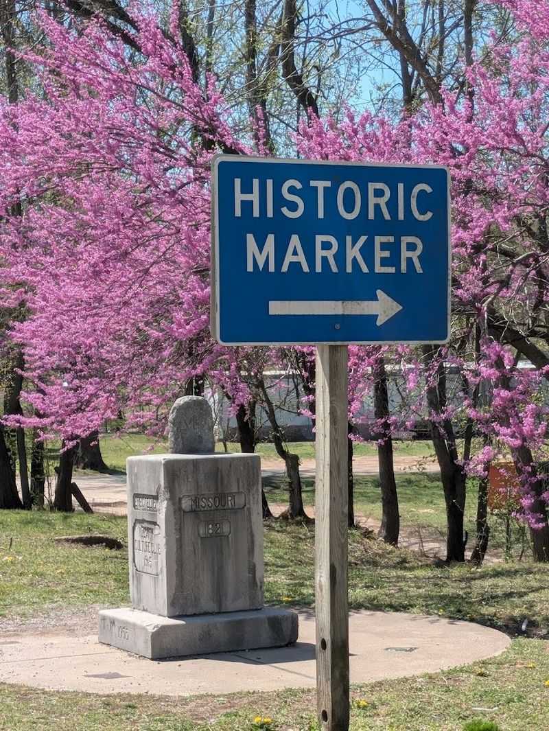
Quiet Highway Crossing Hiding A Three Border Point
Not every remarkable place announces itself with a grand entrance, and this one is proof of that.
Cruise along a rural Ozark highway and it is easy to miss, just a calm stretch of road flanked by green hills and open sky, with nothing demanding your attention.
The crossing sits right where three state lines converge, and the only hint something special is happening is a modest monument near the shoulder.
Traffic moves at a steady pace here, which makes slowing down and paying attention genuinely important as you approach.
Some road trippers pass by at first before spotting the marker at the last second and circling back for a closer look.
The highway itself carries a relaxed rural energy, with farmland and timber on either side creating a backdrop that feels authentically Ozark.
This is the kind of spot that rewards a curious traveler who reads a map closely and follows a hunch. You will find it at the AR-MO-OK Tri-State Marker near South West City, Missouri, at MO-43 and OK-20, close to AR-43.
Stacked Stone Monument Marking Exact State Junction
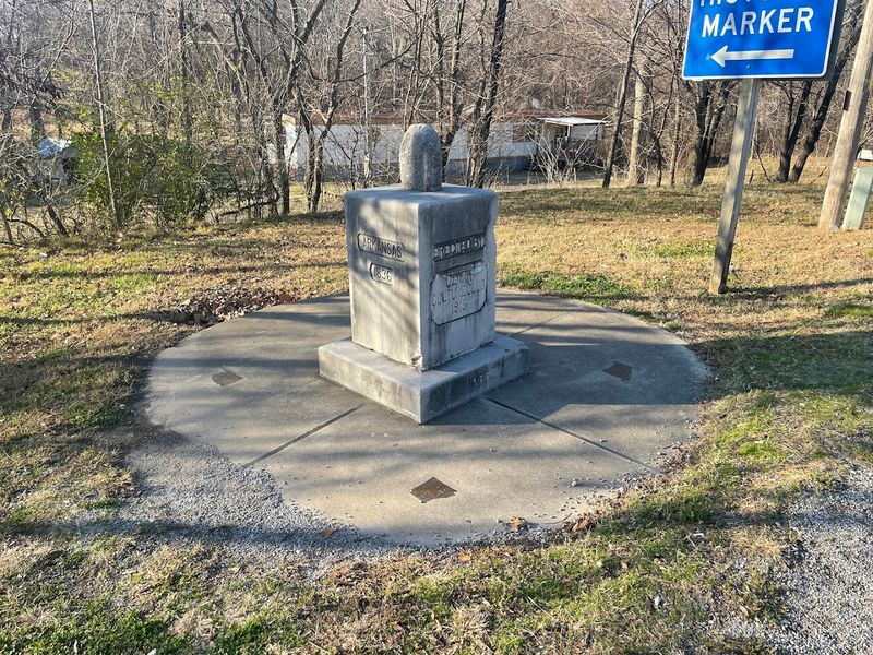
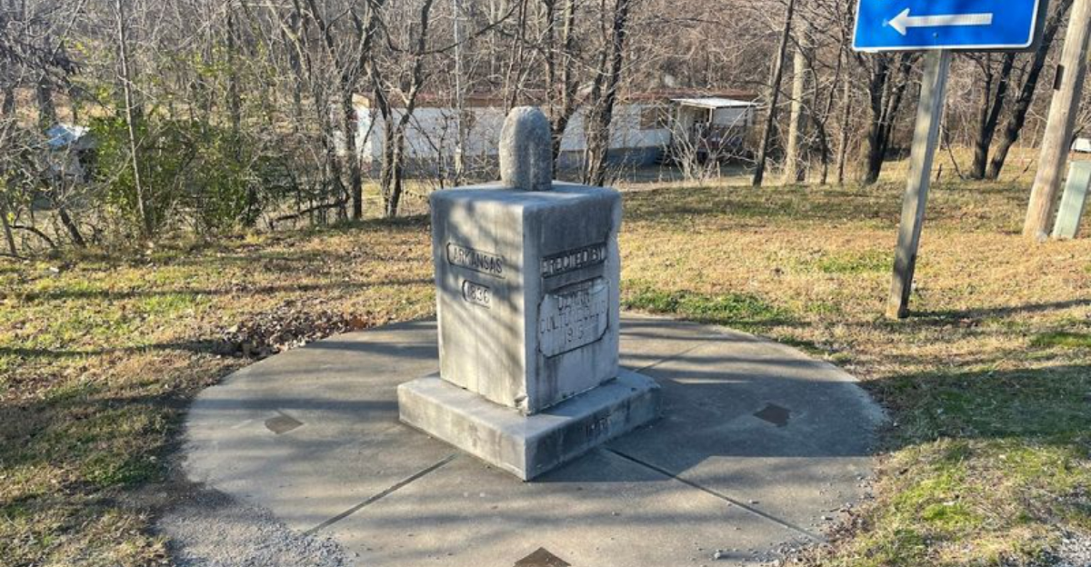
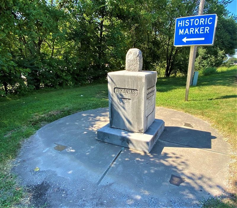
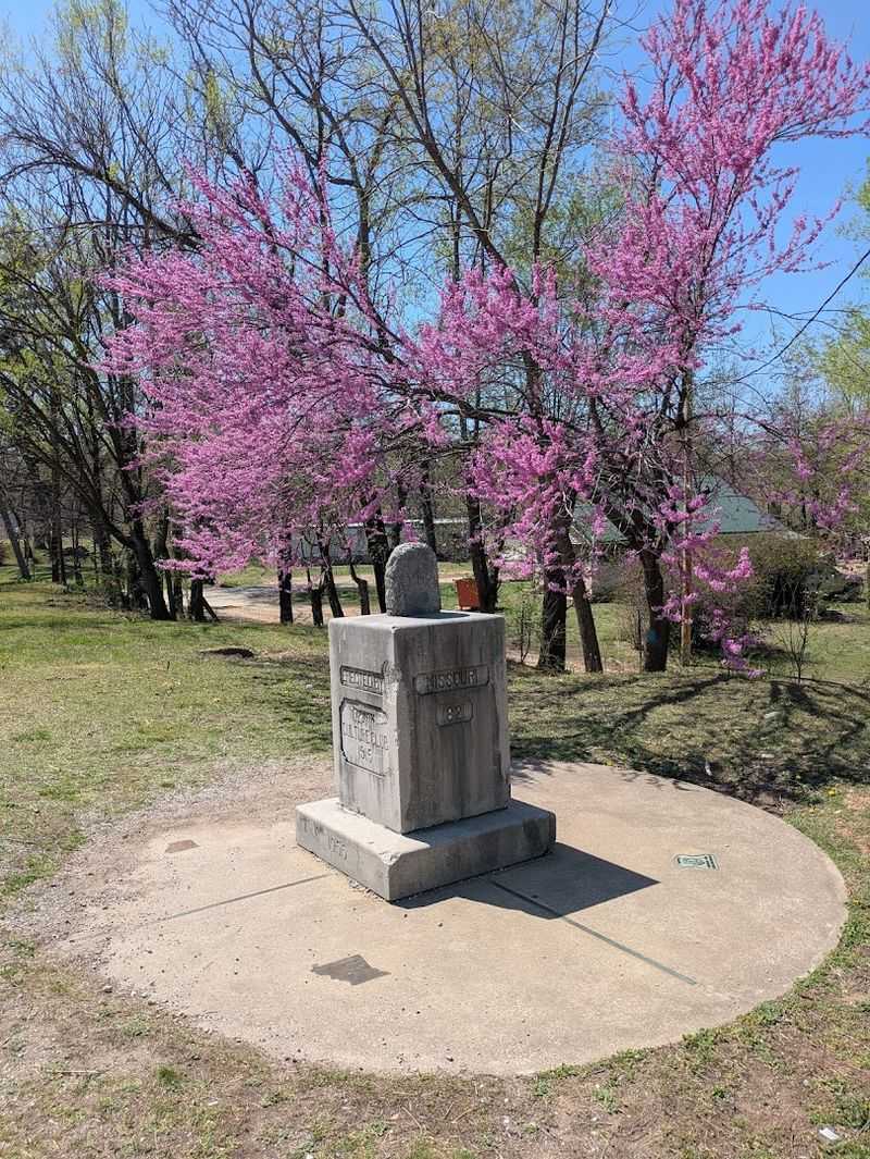
Few roadside monuments carry as many layers of history as this one, and that is almost literal.
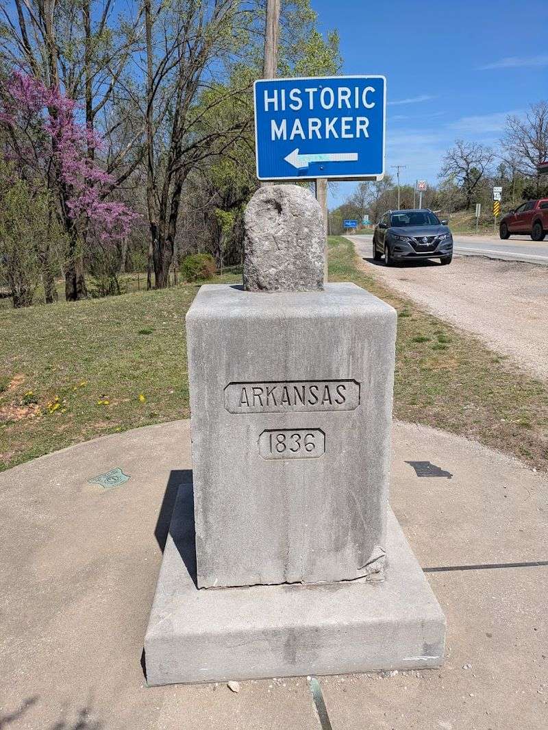
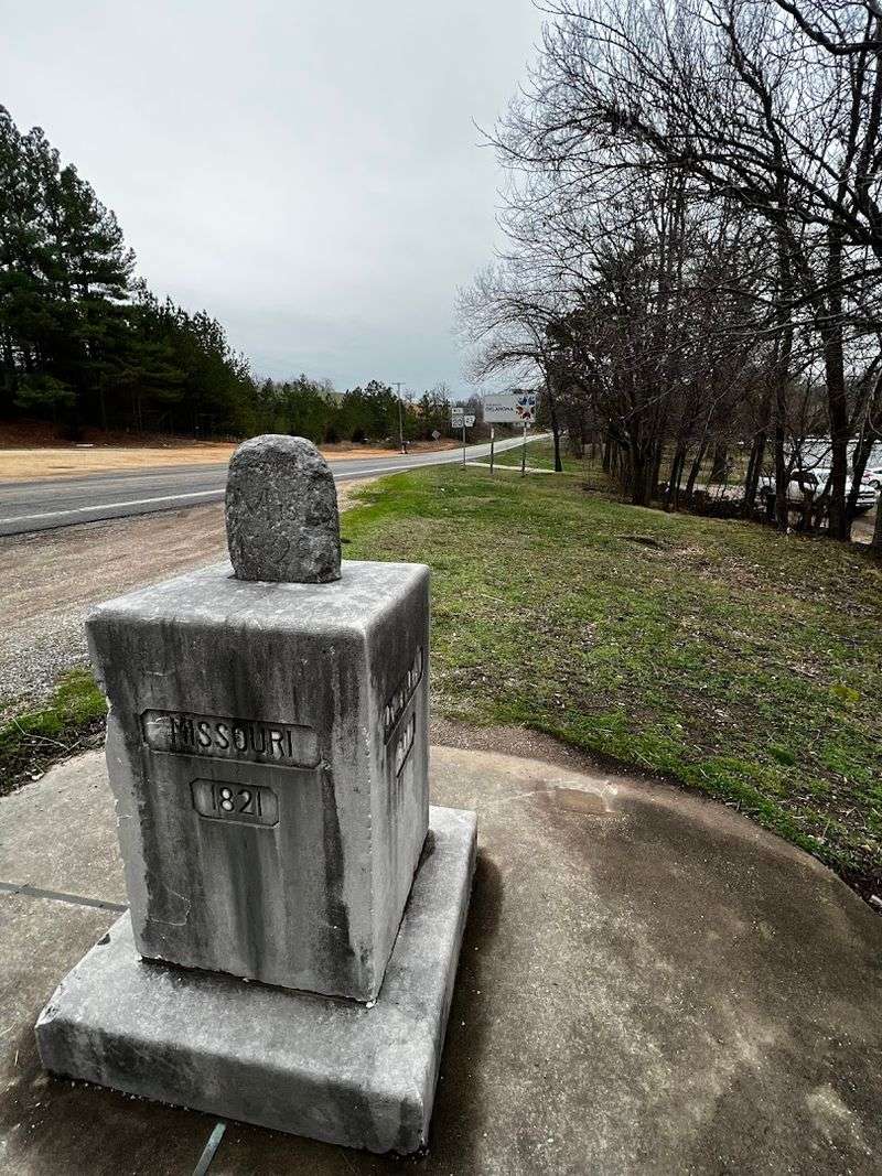
The structure at the tri state junction is made up of three distinct components stacked on top of each other, each placed by a different group at a different point in time.
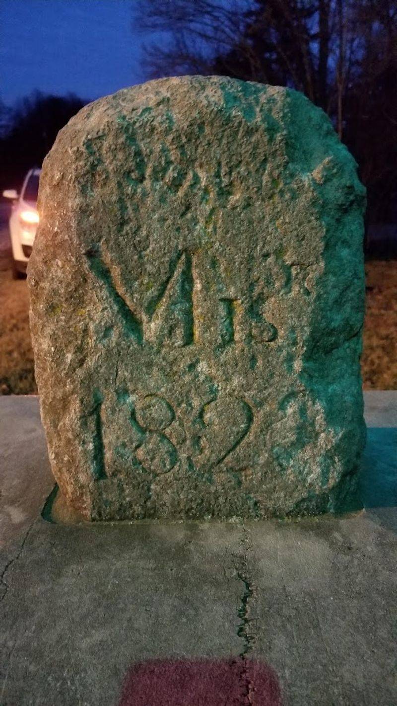
At the very top sits a stone believed to date to the 1820s, inscribed with “Mis. 1821” and “Ark.” to reflect Missouri’s early statehood era following the Missouri Compromise of 1820.
Below that rests a marble pedestal installed by the Ozark Culture Club in 1915, engraved with each state’s name and its admission date, which gives the monument a kind of stony record of regional history.
The base is a cement circle restored or augmented by the Lions Club in the mid 20th century, complete with bronze lines radiating outward to show exactly where each state begins.
Visitors often trace those bronze lines with a sneaker, half expecting a buzzer to go off when crossing from one state into another.
The whole assembly is compact but surprisingly detailed, and it rewards anyone who takes a moment to read every inscription carefully.
One Step Shift Between Three Jurisdictions
Few places allow a single casual step to place you under an entirely different set of state laws, and this corner of the Ozarks is one of them.
Place one foot in Arkansas, shift toward Missouri, and lean slightly toward Oklahoma, and you have technically entered three jurisdictions at once.
The sensation feels oddly powerful, like geography has become something you can physically interact with.
The experience stays playful and works for all ages, from kids who think it is the coolest trick ever to adults who quietly enjoy the novelty while pretending to be too mature for it.
Some visitors note that lying down flat makes it easier to span all three states at once, turning the moment into a simple challenge.
Nearby welcome signs for Oklahoma and Missouri give you the chance to grab a couple of quick state photos within a short distance.
Crossing these invisible lines turns an ordinary road trip pause into a small, memorable experience that is hard to replicate anywhere else nearby.
Roadside Pull Off Beside Rural Route 43 Curve
Practical parking matters at any roadside stop, and this one handles it about as well as a small shoulder area can.
Just off the curve of Route 43, a pull off area on the same side as the marker allows a few cars to park while visitors step out to take a look.
Across the road, a convenience store provides additional space if the shoulder area is already full when you arrive.
Weekday visits often mean open space, though busier times may require a bit of patience before a spot becomes available.
The curve in the road means approaching drivers may not see you immediately, so staying alert and keeping clear of the travel lane is a smart move.
Gravel around the marker can shift underfoot, so wearing sturdy shoes makes moving around the monument easier.
Overall, the setup stays simple and functional, giving enough room to park, stretch, take a photo, and continue the drive without much effort.
Weathered Historical Sign Near The Boundary Marker
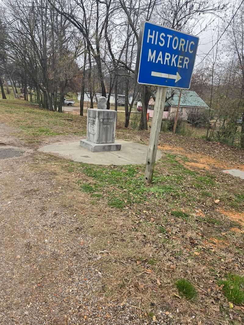
History shows up in unexpected places, and at this stop it appears in the form of a weathered sign beside the monument.
The sign provides context for what stands in front of you, connecting the physical stones to the broader story of how these three state lines came to meet at this exact point.
The Missouri Compromise of 1820 helped establish the framework that eventually shaped these borders, and the top stone is associated with that early period in American history.
Reading the sign feels like stepping into a short history lesson while standing outside in the open Ozark air.
The signage is not flashy or museum quality, but it carries real informational weight that helps visitors understand why this specific location earned a monument.
Time and weather have left visible wear along the edges, adding to the sense that the marker has stood here through decades of change.
A few minutes spent reading it adds depth to the experience beyond a simple photo stop.
Gravel Shoulder Parking With Immediate Landmark Access
One of the most convenient aspects of this stop is how quickly the experience moves from car door to monument.
Park on the gravel shoulder, take a few steps, and you are already at the marker, making it one of the more efficient roadside attractions to visit.
No trail, no ticket booth, and no entrance fee stand between you and the landmark, which keeps the stop simple and accessible.
The gravel surface is easy enough to walk across, though it can shift after rain, so steady footing near the marker is worth a moment of attention.
A convenience store across the road adds a bit of extra convenience if you need a quick break before continuing the drive.
Travelers often pause for a few minutes after visiting, watching others slow down and notice the marker for the first time.
That immediate access from roadside to monument is a small detail that makes the entire stop feel smooth and enjoyable.
Subtle Landscape Change Across Invisible Borders
Stand at the marker and look outward in each direction, and a quiet shift in the landscape begins to stand out depending on where you face.
The Ozark region stretches across all three states, so rolling hills and mixed forest feel continuous, yet small differences in light, road texture, and vegetation appear with a closer look.
Arkansas extends southward with dense ridgelines, Missouri opens into broader farmland to the north, and Oklahoma transitions into slightly gentler terrain toward the west.
No fence marks where one state ends and another begins, which gives the area a sense of uninterrupted countryside.
Turning slowly in place makes it difficult to pinpoint exactly where one landscape changes into another.
That uncertainty adds to the experience, reminding you that state lines exist on maps while the natural surroundings remain connected.
The scenery alone makes the stop worthwhile, offering a calm view of the Ozarks from a uniquely defined point.
Quick Photo Stop At A Rare Triple State Intersection
Some road trip stops require hours, while others fit perfectly into a short pause, and this one lands firmly in the second category.
Pull up, step out, take a few photos, and read the inscriptions, and the entire visit usually takes between five and fifteen minutes depending on how long you stay.
The bronze lines set into the concrete circle create a clear and photogenic way to capture the moment, especially from a slightly elevated angle.
Groups often turn the experience into a small game, stepping between states and keeping track of each crossing for fun.
Nearby welcome signs for Oklahoma and Missouri make it easy to add a couple of extra photos within a short drive.
Low light conditions can make visibility more limited, so extra caution is helpful when visiting later in the day.
For anyone building a road trip through the Ozarks, this remains one of the most shareable and low effort stops, and the monument near South West City, Missouri at the Arkansas Missouri Oklahoma tripoint along Route 43 delivers every time.