13 Arkansas Hikes Under Five Miles With Amazing Views
Arkansas keeps things interesting on the trail. You think it is just another walk, then the path bends and suddenly you are looking out over miles of hills and sky.
I live for that moment. Boots on, quick hike, then pause and take it all in.
These trails make it easy. None of them go over five miles, so you are not signing up for an all day trek.
You get the climb, the view, and still have time left to relax after. It is the sweet spot.
Some overlooks feel wide open and dramatic, others feel quiet and personal, like you found your own little corner of the world. That mix is what makes this list fun.
All solid choices when you want something short but still memorable. Go for the views, stay a while, then head back already thinking about the next one.
1. West Summit Trail, Pinnacle Mountain State Park
Standing on top of Pinnacle Mountain feels like the whole state of Arkansas has been laid out just for you to admire.
The West Summit Trail at Pinnacle Mountain State Park, located near Roland, AR 72135, is the more challenging of the two summit routes, featuring a rocky scramble near the top that adds a little adventure to the climb.
The trail covers roughly 1.5 miles round trip, but the bouldering section near the peak demands your full attention and both hands at times.
Once you reach the top, the Arkansas River Valley stretches out in every direction, and on a clear morning, the view is the kind that makes you forget how much your calves are burning.
Spring and fall offer the most comfortable temperatures and the most dramatic colors on the hillsides below.
Arrive early on weekends to snag a parking spot, because this trail is a local favorite that fills up fast.
2. East Summit Trail, Pinnacle Mountain State Park
The East Summit Trail offers a rugged alternative to the west side, trading a bit of polish for a more demanding and adventurous climb.
This trail at Pinnacle Mountain State Park near Roland, AR 72135 runs about 2 miles round trip and follows a steeper, rockier route that requires careful footing and steady effort for much of the ascent.
The path winds through dense woodland before transitioning into exposed sections where large rock slabs and uneven terrain slow your pace and demand attention.
Hikers should expect to use their hands at times, especially near the summit, where the climb becomes more technical than it first appears.
Reaching the top still rewards you with sweeping views, but the journey feels earned in a different way compared to the west route.
The eastern perspective from the summit provides a fresh angle on the surrounding landscape that makes the tougher climb worthwhile.
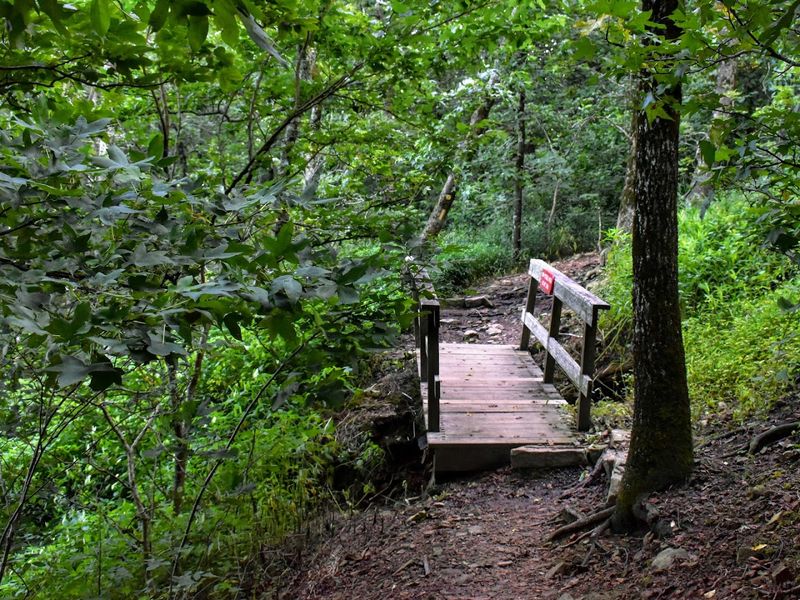
3. Yellow Rock Trail, Devil’s Den State Park
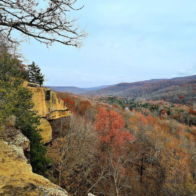
The moment the trees part at Yellow Rock overlook delivers one of the most striking views in northwest Arkansas.
The Yellow Rock Trail at Devil’s Den State Park, located near West Fork, AR 72774, covers about 3 miles round trip and winds through one of the most geologically interesting corners of the Arkansas Ozarks.
Sandstone bluffs and crevice caves along the route make the journey just as interesting as the destination itself.
Yellow Rock, the namesake sandstone outcropping at the end of the trail, sits above the valley like a natural balcony, and the views from its surface are genuinely hard to top anywhere in northwest Arkansas.
The trail is moderately challenging with some elevation gain, but nothing that will leave most hikers struggling.
Fall is an especially good time to make this walk, when the valley below transforms into a patchwork of orange and red that looks almost too good to be real.
4. Lovers’ Leap Trail, Queen Wilhelmina State Park
Queen Wilhelmina State Park sits near the top of Rich Mountain, and the Lovers’ Leap Trail makes sure you appreciate every bit of that elevation with views that stretch deep into the Ouachita Mountains.
The park is located near Mena, AR 71953, and this short trail of roughly 1 mile round trip is one of those rare hikes where the payoff feels wildly disproportionate to the effort required.
The overlook at the end frames a sweeping panorama of forested ridgelines that seem to stack up endlessly toward the horizon, especially beautiful in the golden light of late afternoon.
The park itself has a fascinating history tied to a Dutch queen who never actually visited but lent her name to a grand hotel built here in the late 1800s, which adds a quirky layer to the experience.
Wildlife sightings are common along this short path, including deer and various hawks riding the thermals above the ridges.
Pack a picnic and plan to linger here longer than you think you will.
5. Rim Trail, Mount Nebo State Park
Walking the Rim Trail at Mount Nebo State Park feels like circling the top of a natural watchtower placed right in the middle of the Arkansas River Valley.
Located near Dardanelle, AR 72834, the Rim Trail runs about 3.5 miles around the perimeter of Mount Nebo’s flat-topped summit, offering continuous peekaboo views through the trees and several open overlooks where the valley spreads out dramatically below.
The relatively flat terrain of this rim walk makes it accessible for a wide range of hikers, including those who prefer a longer stroll over a steep climb.
One of my favorite sections is the western overlook, where the Arkansas River catches the late afternoon sun and glints like a ribbon of hammered copper through the green patchwork of fields below.
The park also has cabins and camping, so spending a night here and catching both sunset and sunrise from the rim is absolutely worth considering.
Bring water and sunscreen for the more exposed sections of the trail.
6. Bench Trail, Mount Nebo State Park
Not every great trail needs to deliver a single dramatic overlook moment, and the Bench Trail at Mount Nebo State Park makes a convincing case for the beauty of a quieter, more wooded experience.
This trail near Dardanelle, AR 72834 runs roughly 4 miles and hugs the middle slope of Mount Nebo, traveling through shaded hardwood forest that keeps things cool even on warmer days.
The name comes from the bench-like shelf of land the trail follows around the mountain, and the route occasionally opens up to filtered views of the surrounding countryside through breaks in the canopy.
It connects with other trails in the park, making it a great option for building a longer loop or using it as a return route after summiting via a different path.
Wildflowers bloom along the trailside in spring, and the moss-covered rocks and ferns give the forest floor a lush, almost storybook quality.
This is the trail I recommend to people who want solitude and greenery over crowds and summit selfies.
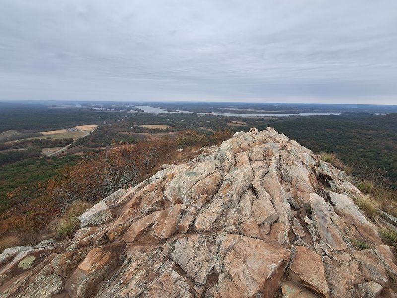
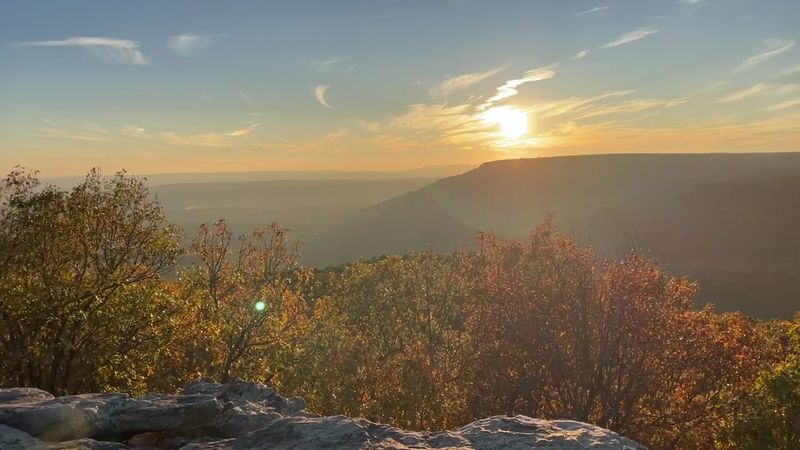
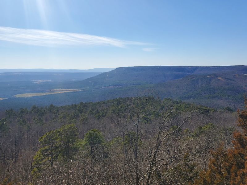
7. North Rim Trail, Mount Magazine State Park
Mount Magazine is the highest point in Arkansas, and the North Rim Trail makes sure you feel every bit of that distinction with views that seem to reach halfway across the state.
Located near Paris, AR 72855, the North Rim Trail runs about 2.2 miles and follows the northern edge of Magazine’s flat-topped summit, passing multiple rocky overlooks that each frame a slightly different angle of the valley floor far below.
The views toward the Arkansas River Valley from these overlooks are genuinely stunning, with layers of ridgelines fading into blue haze in the distance that photographers absolutely love.
The trail surface is generally well-maintained and not overly technical, though some rocky sections near the rim edge require a bit of careful footing.
Early morning visits reward hikers with the chance to see fog filling the valleys below while the summit stays clear and bright in the rising sun.
Few trails in the state match this one for sheer visual drama per mile walked.
8. Signal Hill Trail, Mount Magazine State Park
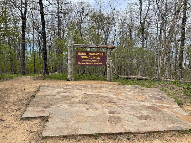
Reaching the highest point in Arkansas sounds like a serious undertaking, but Signal Hill Trail makes it surprisingly approachable for most hikers willing to put in a short effort.
At Mount Magazine State Park near Paris, AR 72855, this trail is just about 0.6 miles round trip from the trailhead to the summit marker at Signal Hill, the official high point of the Natural State.
The hike itself is short and not especially strenuous, but the views from the top are a genuine reward, with the surrounding Ouachita and Boston Mountains visible on clear days in a wide arc around the summit.
Standing at the highest point in the state has a satisfying quality that goes beyond the physical effort, and the summit marker makes for a classic trail photo.
The park’s lodge and visitor center are nearby, making this a natural starting point for a full day of exploring multiple trails across the mountain.
Sunsets from this elevation are the kind you talk about long after you have driven home.
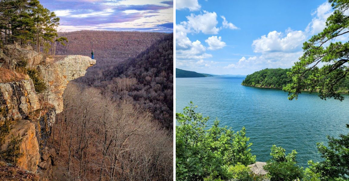
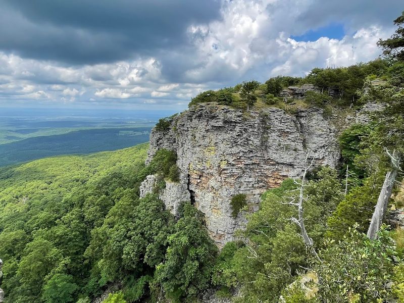
9. Whitaker Point (Hawksbill Crag) Trail, Ozark–St. Francis National Forest
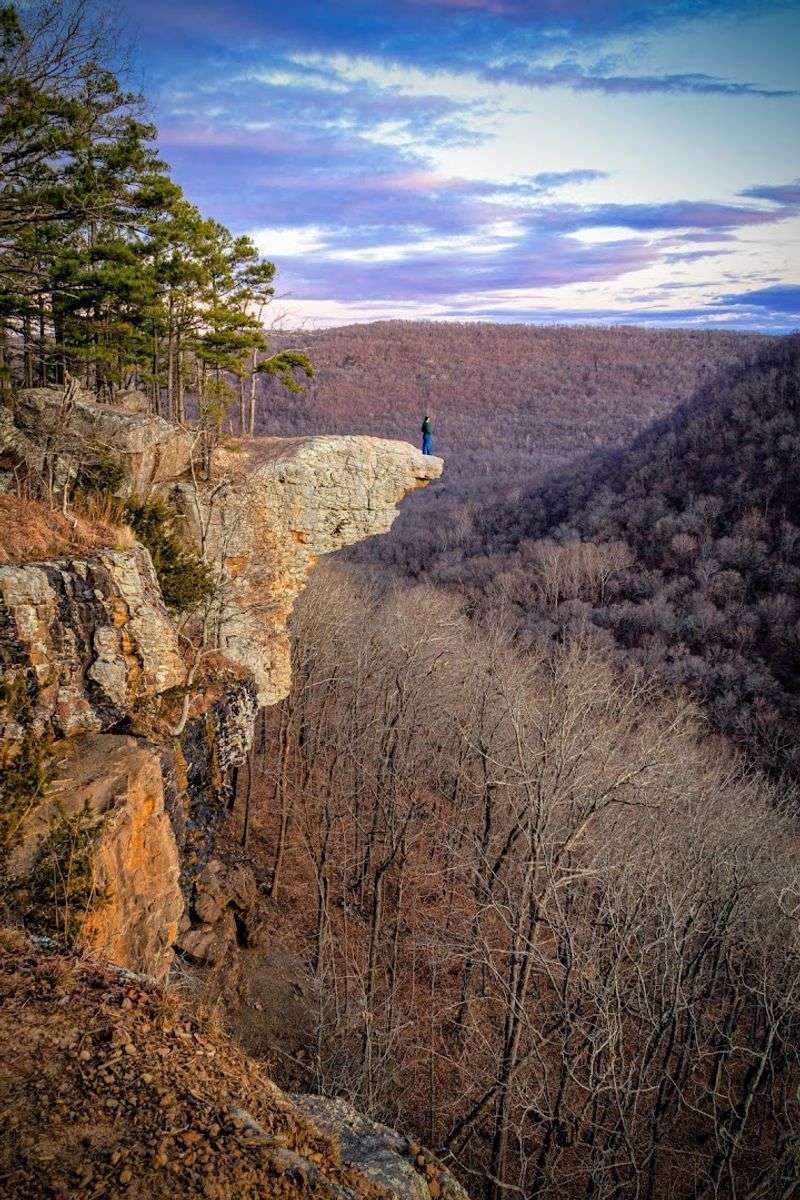
Hawksbill Crag might be the single most photographed rock formation in all of Arkansas, and once you see it in person, that reputation makes complete sense.
The Whitaker Point Trail in the Ozark-St. Francis National Forest near Boxley, AR 72613 covers about 2.7 miles round trip through dense Ozark forest before delivering you to a narrow sandstone promontory that juts dramatically out over a deep, forested valley with no guardrails and no distractions.
The trail itself is moderately challenging with some uneven terrain and creek crossings, but nothing that will stop a reasonably fit hiker from reaching the crag.
Sunrise visits here are borderline legendary among Arkansas hikers, as the morning light fills the valley below and the mist burns off the treetops in slow, cinematic waves.
The Buffalo National River area surrounding this trail adds to the overall wildness of the experience, with ridgelines and hollows stretching out in every direction.
Go on a weekday if possible, because weekend crowds at this trail can be surprisingly large for such a remote location.
10. Pedestal Rocks Trail, Pedestal Rock Scenic Area
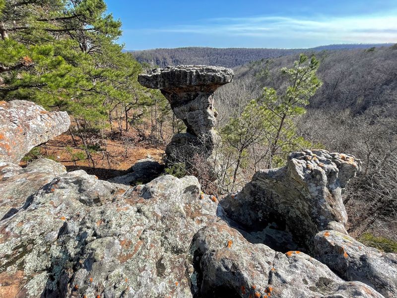
The Pedestal Rocks Scenic Area in the Ozark National Forest feels like a place shaped by imagination rather than time.
Located near Pelsor, AR 72856, the Pedestal Rocks Trail runs about 2.2 miles and leads through hardwood forest to a series of enormous sandstone formations that balance on narrow pedestals carved by millions of years of erosion.
The formations themselves are the main attraction, rising dramatically above the canyon floor and framed by the surrounding forest in a way that rewards every angle you try to photograph them from.
The canyon overlooks along the route add sweeping views of the surrounding Ozark landscape, making this trail a two-for-one experience of both geological wonder and scenic beauty.
Spring wildflower season turns the forest floor along this trail into a colorful carpet that makes the walk to the rocks even more enjoyable.
Plan for a few hours here because the formations are too interesting to rush past.
11. Kings Bluff Trail, Pedestal Rock Scenic Area
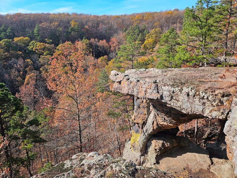
Kings Bluff Trail shares its starting point with the Pedestal Rocks Trail but heads off in its own direction to deliver one of the finest canyon rim views in the entire Ozark National Forest.
Located near Pelsor, AR 72856, this trail covers roughly 1.7 miles and leads to a dramatic bluff edge where the canyon drops away sharply below and the surrounding ridgelines fill the horizon in every direction.
The rocky bluff itself is wide enough to walk along comfortably, and the views down into the wooded canyon below have a depth and scale that photographs genuinely struggle to capture.
The forested path leading to the bluff is peaceful and shaded, passing through classic Ozark hardwood forest with plenty of interesting rock formations along the way before the big reveal at the rim.
Combining this trail with the Pedestal Rocks Trail makes for a full and deeply satisfying day of hiking in one of Arkansas’s most underrated scenic areas.
This bluff is the kind of quiet discovery that makes you feel like you found something most people have missed.
12. Horseshoe Mountain Trail, Lake Catherine State Park
Lake Catherine State Park is one of the quieter gems in the Arkansas state park system, and the Horseshoe Mountain Trail gives you the most scenic way to explore its forested ridgelines above the lake.
Located near Hot Springs, AR 71913, this trail runs about 3 miles and winds through mature hardwood and pine forest along a horseshoe-shaped ridge that provides periodic glimpses of Lake Catherine sparkling through the trees below.
The combination of lakeside beauty and forested ridge walking makes this trail feel more varied than its modest length suggests, with the terrain shifting between open ridgeline and shaded hollow several times along the route.
Wildlife is abundant in this park, and it is not unusual to spot deer, wild turkey, or even a box turtle crossing the path during a morning hike.
The trail is well-marked and not overly technical, making it a comfortable choice for hikers of most experience levels who want a peaceful outing near Hot Springs.
The lake views from the higher sections of the ridge make every step of the climb feel entirely justified.
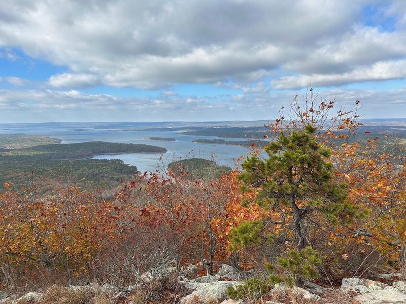
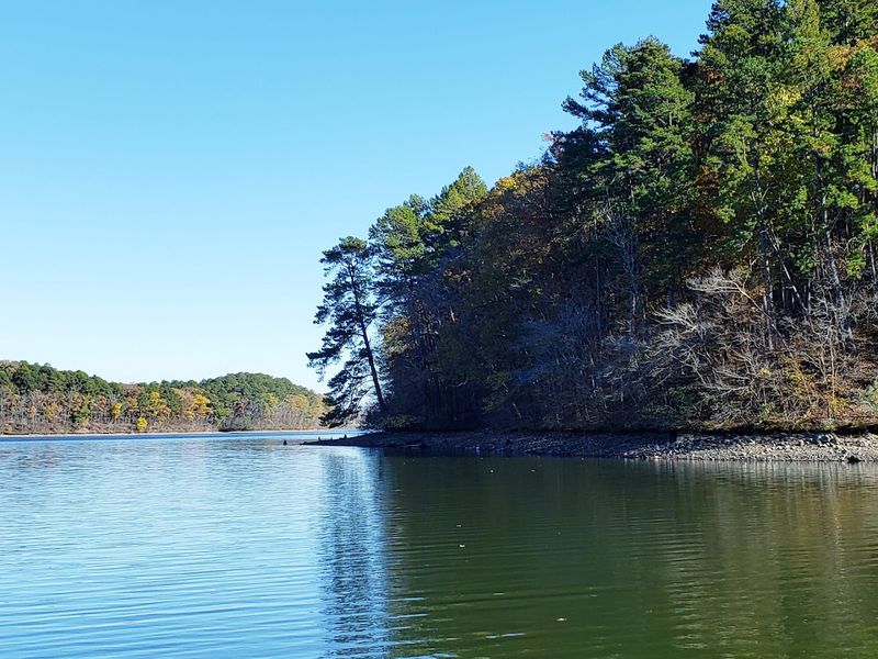
13. Caddo Bend Trail, Lake Ouachita State Park
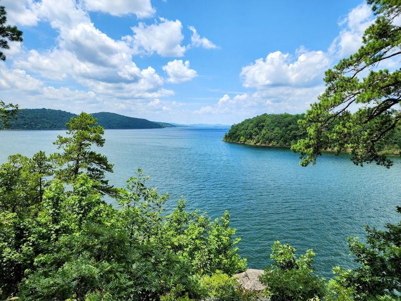
Lake Ouachita is the largest lake entirely within Arkansas, and the Caddo Bend Trail puts that stunning body of water right at your side for much of its length.
Located near Mountain Pine, AR 71956, this trail covers about 3.5 miles round trip and follows the shoreline of the Caddo Bend peninsula through a mix of pine and hardwood forest, with the lake appearing and disappearing through the trees in a way that keeps the scenery feeling fresh throughout the walk.
The water here is famously clear, and the color of the lake on a sunny day shifts between deep blue and vivid green depending on the light and the depth below.
Rocky shoreline sections along the trail invite you to stop, sit on a sun-warmed boulder, and watch the water for a while without any particular reason to hurry.
Fall foliage reflected in the calm surface of the lake creates a mirror-image effect that feels almost surreal and is worth timing a visit around.
This trail is proof that Arkansas lakeside hiking can hold its own against any view in the state.