This Charming Arkansas Town Offers River Views, Rich History, And A Touch Of Outlaw Lore
This town along the Arkansas River in Yell County knows how to make an entrance. I rolled in thinking I’d stretch my legs and move on.
That didn’t happen. The sandstone bluffs pulled my attention right away, especially with the lake stretching out nearby and a mountain rising in the distance.
It feels open, calm, but also full of stories. Locals talk about river trade, older days, even a few outlaw connections that still linger in conversation.
Nothing feels forced. It just unfolds as you spend time there.
The streets carry that worn-in character that makes everything feel grounded. You start noticing details, then lose track of time.
It’s not loud or flashy, and that’s exactly the point. Arkansas road trips need stops like this, places that surprise you without trying and leave you thinking about them long after you’ve gone.
Arkansas River And Lakefront Vistas
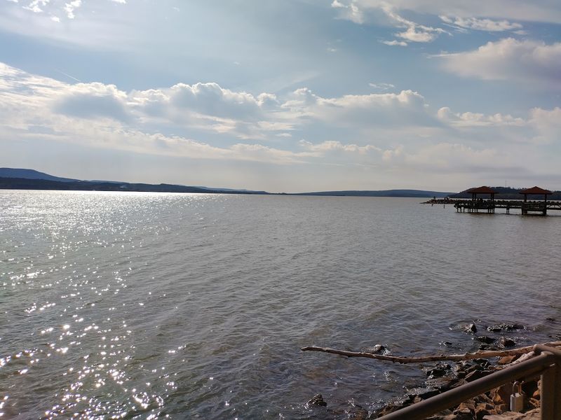
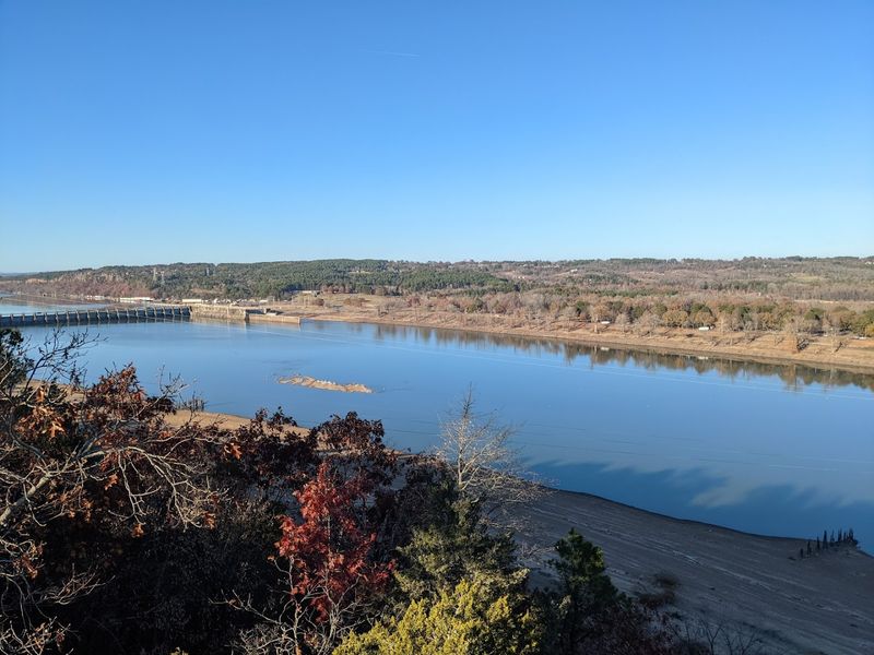
Standing at the edge of Lake Dardanelle on a calm morning, the water stretches out so wide and still that it almost feels like the horizon has been borrowed from the coast.
Lake Dardanelle is a reservoir created by the Dardanelle Lock and Dam on the Arkansas River, covering roughly 34,000 acres and offering some of the most striking freshwater views in the entire state.
The shoreline shifts personality depending on where you stand, from grassy banks ideal for a slow afternoon to rocky edges where the current still hints at the river’s original power.
I found a quiet spot near the water one evening and watched the light turn the surface from silver to deep gold as the sun dropped behind the ridge.
Birdwatchers tend to linger here too, since herons, egrets, and osprey all make regular appearances along the marshy edges of the lake.
The connection between the river and the town is not just visual either, it shaped the economy, the culture, and the identity of this place for generations.
Few towns in Arkansas wear their relationship with water as openly and proudly as Dardanelle does every single day.
Mount Nebo Overlooks And Cliffside Horizons
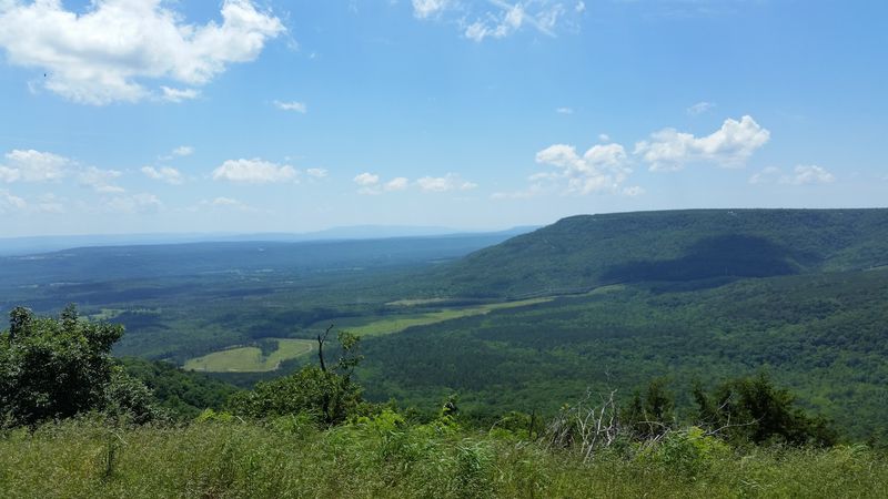
Rising about 1,350 feet above sea level just a short drive from town, Mount Nebo rewards every switchback with a view that genuinely stops conversation.
Mount Nebo State Park sits atop a flat-topped mountain that juts up from the Arkansas River valley floor, making it one of the most visually distinctive landmarks in the entire region.
The overlooks along the rim trail offer unobstructed sightlines across the river, the lake, and the patchwork of farmland and forest stretching toward the horizon.
I remember gripping the wooden railing at one of the cliffside viewpoints and feeling the warm updraft rising from the valley below, carrying the faint smell of pine and river mud.
Hiking trails loop around the mountain’s edge, ranging from easy strolls to more challenging paths that dip into the forested slopes below the rim.
Cabins and camping facilities inside the park mean visitors can stay overnight and catch both sunset and sunrise from one of the most dramatic perches in Arkansas.
Honestly, the view from that rim at golden hour is the kind of thing that quietly rearranges your expectations of what a state park can actually deliver.
Historic Riverport Trade And Cotton Routes
Long before highways crossed Arkansas, the river did the heavy lifting, and Dardanelle sat right at one of its most strategically important crossing points.
During the 19th century, the town functioned as a key riverport, with steamboats carrying cotton, timber, and trade goods up and down the Arkansas River between Little Rock and Fort Smith.
Cotton was among the major goods moving through the surrounding Yell County farmland, and the docks at Dardanelle served as the loading point where bales moved from wagon to boat and on to distant markets.
Older parts of town reveal small architectural details, a wide commercial facade here, a warehouse footprint there, that quietly point back to those busy trading days.
The river crossing at Dardanelle also made it a natural waypoint for travelers and merchants moving westward, giving the town an outsized commercial importance relative to its modest size.
Local historical markers scattered around the downtown area fill in the gaps, connecting modern storefronts to the steamboat captains and cotton merchants who once made this stretch of river hum with activity.
That layered commercial past gives the town a depth that can still be sensed while moving through its older streets.
Early Settlement Roots From Mid 1800s
Dardanelle’s story as a formal settlement stretches back to the 1840s, when the land along this bend of the Arkansas River began attracting families looking for fertile ground and a reliable water source.
The town was officially incorporated in 1855, and by the time the Civil War arrived, it had already developed a recognizable identity as a river crossing community with growing commercial ambitions.
Yell County itself was established in 1840, named after Arkansas Governor and Congressman Archibald Yell, and Dardanelle grew alongside it as one of the county’s anchor communities.
I spent some time at the Yell County Historical and Genealogical Association, where local records and photographs paint a vivid picture of the town’s earliest decades.
The challenges those first settlers faced were considerable, from unpredictable river floods to the political upheaval of the Civil War era, yet the community managed to hold together and rebuild each time.
Evidence of that resilience shows up in the architecture, with certain buildings downtown carrying construction dates that push well back into the post-Civil War reconstruction period.
There is something quietly humbling about standing in a town that has been continuously inhabited and rebuilt by the same community for nearly two centuries.
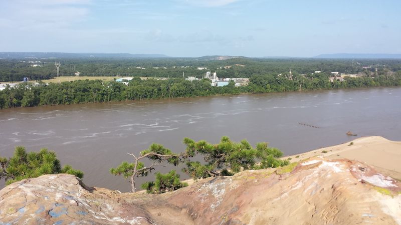
Prominent Sandstone Bluff Landmark
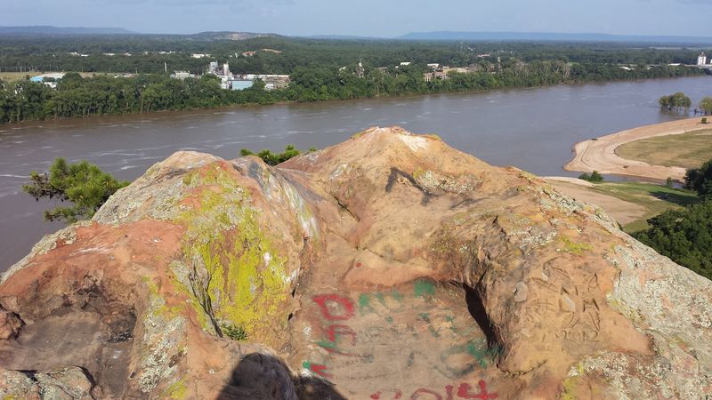
Few natural features in this part of Arkansas announce themselves as boldly as the sandstone bluff that rises near the edge of town, its reddish-brown face catching the afternoon sun in a way that makes it look almost painted.
This bluff is one of the defining visual landmarks of Dardanelle, visible from the river and from several points around the lake, and it has served as a geographic reference point for travelers in this region for centuries.
The rock formation belongs to the broader geology of the Arkansas River Valley, where ancient sedimentary layers have been pushed upward and eroded into the dramatic ridges and bluffs that characterize the landscape.
I pulled over on the road near the base of the bluff just to stand there for a few minutes and take in the scale of it, because photographs honestly do not capture how it dominates the skyline.
Local lore connects the bluff to the town’s name, which some historians trace back to the Dardanelles strait in Turkey, possibly applied by early French explorers who found the river passage here equally imposing.
Whether that etymology holds up or not, the bluff itself earns the comparison through sheer presence alone.
True Grit Trail Frontier Connections
Charles Portis, the Arkansas author who wrote the novel True Grit, set much of his frontier story in the Arkansas River Valley, and the landscape around Dardanelle closely reflects that setting.
The True Grit Trail is a driving and heritage route that connects communities across western Arkansas, tracing the territory where the fictional U.S. Marshal Rooster Cogburn and young Mattie Ross pursued outlaws through Indian Territory.
Dardanelle sits within this corridor, and the town’s location along a historic river crossing helps ground the trail in a real geographic setting rather than purely literary tourism.
Traveling sections of the route reveals how the geography aligns with the tone of the story, rugged, open, and at times unpredictable.
Fort Smith, where Judge Isaac Parker held court over Indian Territory, is not far to the west, and the broader region reflects a period when frontier justice played a visible role in daily life.
Stopping in Dardanelle along this route adds a layer of river history and small-town character that makes the trail feel complete rather than just a series of highway signs.
The frontier remains present here more through landscape and story than through any single historical site.
Boating Fishing And Lakeside Recreation
Lake Dardanelle is one of Arkansas’s top fishing destinations, and the locals will tell you that with the kind of quiet confidence that comes from decades of early mornings on the water.
The lake holds largemouth bass, striped bass, catfish, crappie, and bream, making it attractive to anglers at every skill level from weekend hobbyists to serious tournament competitors.
Several boat ramps and marinas around the lake provide easy access, and the Arkansas River navigation channel that runs through it adds an interesting dynamic to the fishing zones.
I rented a small boat one morning and spent a few hours drifting along the quieter coves on the south side of the lake, where the water turns glassy and the only sounds are birds and the occasional distant motor.
Beyond fishing, the lake supports a full range of water recreation including kayaking, paddleboarding, waterskiing, and pleasure boating, with enough surface area that different groups rarely crowd each other.
Dardanelle State Park on the lake’s edge offers picnic areas, swimming access, and a campground that fills up quickly on summer weekends for good reason.
If the water calls to you, this lake will answer back with something worth the trip every single time.
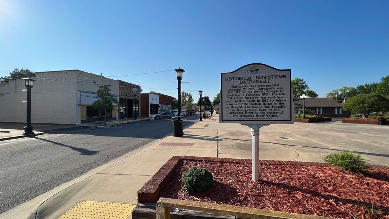
Small Town Streets With Preserved Character
The pace of Dardanelle’s downtown streets quickly shows that not every town has traded its personality for a chain restaurant and a parking lot.
The older commercial blocks along the main street feature brick facades and proportioned storefronts that speak to a time when building something meant planning for it to last a long while.
Local businesses, a hardware store, a diner, a small pharmacy, occupy spaces that have clearly seen multiple generations of ownership without losing the essential character of the buildings themselves.
A walk along the main commercial strip on a typical afternoon reveals frequent sidewalk conversations, more than what is often seen in a larger city.
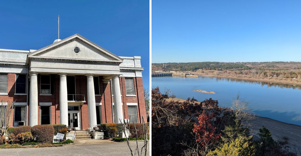
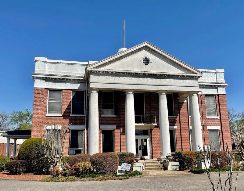
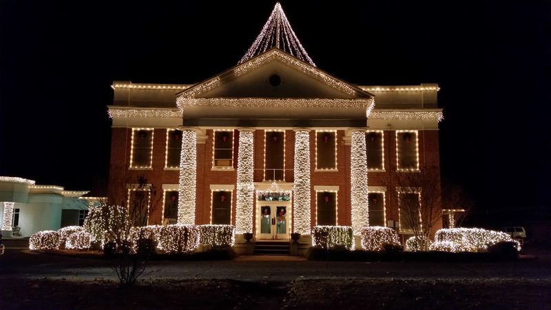
The Yell County Courthouse stands as a central civic landmark, giving this part of town a sense of continuity that feels steady rather than imposing.
Murals on a few building walls nod to the town’s river heritage and agricultural past, adding color to corners that might otherwise go unnoticed by passing visitors.
This is exactly the kind of place that rewards the traveler who slows down long enough to actually look around.