This Scenic Maine Roadside Stop Has A View You’ll Never Forget
Some roads in Maine come with a warning you will never see on a sign: prepare to lose track of time. Along a winding stretch of Route 17, drivers round a bend and suddenly face a view so enormous it barely feels real.
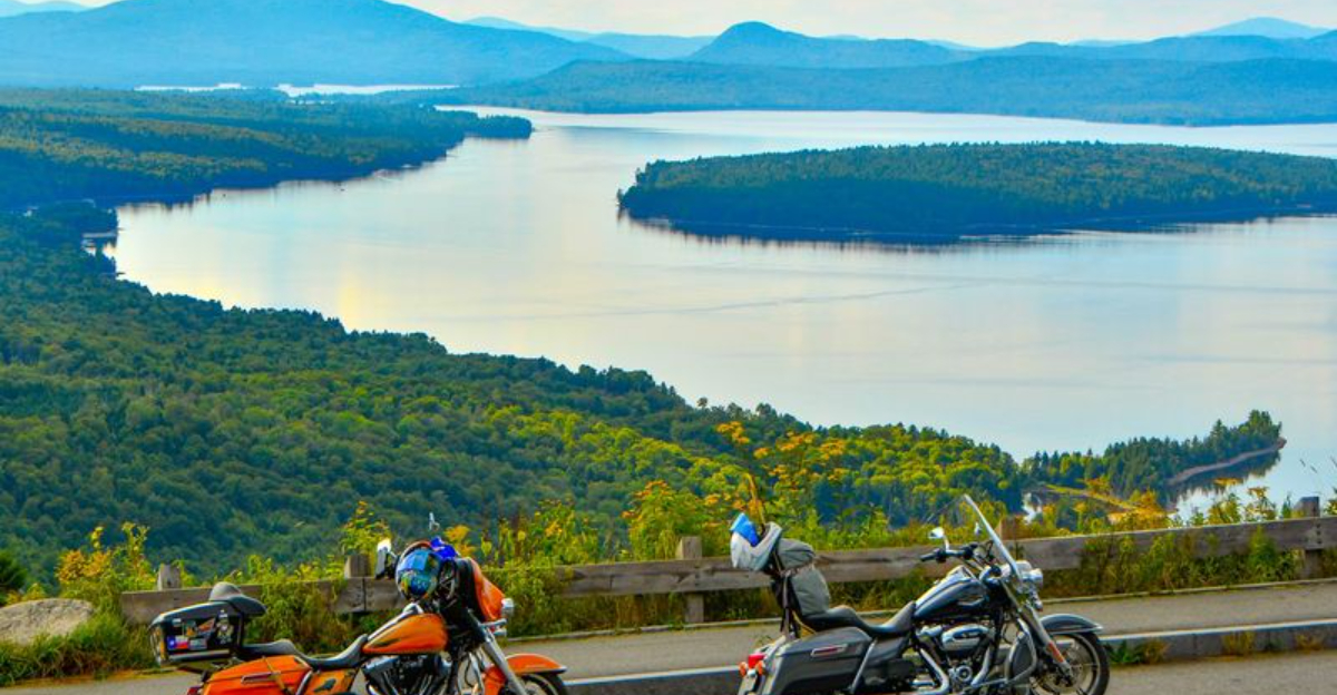
Mountains stack against the horizon in soft blue layers, dark forests spill down steep slopes, and a massive lake flashes silver under the changing light. Cars slow almost instinctively here, and many visitors end up lingering far longer than planned.
This scenic pull-off has become one of the most unforgettable roadside views in New England, drawing photographers, motorcyclists, leaf-peepers, and travelers searching for a quieter side of Maine.
Crisp autumn mornings, glowing sunsets, low drifting fog, and endless ridgelines give the landscape a cinematic quality that stays in your memory long after the drive ends.
The Overlook That Stops Traffic

Most roadside pullouts offer a glimpse of something pleasant. Height of Land, located along ME-17 near Rangeley and Roxbury in western Maine, offers something else entirely.
From the moment you step out of your car, the landscape opens up in every direction like a painting that forgot to stop at the edges.
Mooselookmeguntic Lake stretches out far below, its surface catching the light in ways that shift by the minute. The surrounding mountains roll outward in soft, ancient waves of green and gray.
There is no fence forcing you to stay back, no ticket booth asking for your time.
The overlook sits high above the surrounding lakes and forests, giving the whole experience a rare sense of floating.
Informational signs are posted throughout the area, offering context about the Rangeley Lakes region and the geography spread out before you. It is the kind of stop that turns a road trip into something worth remembering for years.
Maine’s Wildest Lake Name

Say it out loud: Mooselookmeguntic. That name alone is worth the drive.
The lake visible from Height of Land is one of the largest in the Rangeley Lakes chain, and its Abenaki name is commonly translated as moose feeding place. That origin story fits perfectly with the wild, untouched feeling of the entire region.
From the overlook, the lake appears almost impossibly still on calm days, its blue-green surface mirroring the sky above and the ridgelines around it. On windier days, small white ripples texture the water like brushstrokes on a canvas.
Either way, the visual effect is striking.
What makes this particular view special is the distance. You are not standing at the shoreline looking across.
You are elevated high above, taking in the full shape of the water as it curves through the valley. That bird’s-eye perspective transforms a beautiful lake into something that feels genuinely grand and worth savoring slowly.
The Drive Along Route 17

Getting to Height of Land is not just a means to an end. The drive along Route 17 through western Maine builds anticipation in the best possible way.
The road twists through thick forest, dips alongside streams, and climbs steadily through terrain that feels genuinely remote, even though you are never far from a small town.
Coming from Bethel to the south, the road rises through a series of curves that grow more dramatic the further you go. Coming from Rangeley to the north, you descend through similarly beautiful scenery before the overlook appears on your right.
Both directions offer their own rewards.
Motorcyclists have long known about this stretch of road, and on warm weekends you will often see groups of riders pulled over at the overlook, helmets off, taking in the same view everyone else is quietly absorbing. The Rangeley Lakes National Scenic Byway runs through this corridor, and Height of Land is its undisputed centerpiece.
When Fall Takes Over The Mountains

Autumn in Maine is already impressive, but at Height of Land, the fall foliage season hits differently.
When the leaves turn in late September and early October, the mountains surrounding the overlook become a dense mosaic of orange, crimson, gold, and bronze. The lake below picks up those warm tones and reflects them back in soft, shifting hues.
The timing matters. Peak foliage in the Rangeley region typically arrives in late September, though it can shift by a week or two depending on the year.
Arriving on a clear morning during peak week puts you in the middle of one of the most visually intense natural displays the northeastern United States produces.
One practical note: fall weekends get busy early. Photographers, families, and leaf-peepers from across New England make their way up Route 17, and the paved parking area fills quickly.
Arriving before 9 a.m. on a weekend gives you the best chance of finding space and enjoying the scene without a crowd pressing in around you.
The Light Here Feels Unreal

There is a reason photographers set alarms for 4 a.m. and drive hours to reach this overlook before sunrise. When the first light of morning hits the mountains east of Mooselookmeguntic Lake, the entire landscape turns shades of gold and rose that no filter can improve upon.
Fog sometimes sits low in the valleys, making the lakes look like they are floating on clouds. Sunset from the same spot delivers a different mood entirely.
The western sky lights up behind you, casting long shadows across the ridgelines and turning the lake surface into a glowing copper mirror.
The transition from full color to deep blue dusk happens quickly, so staying through the last light is always worth the extra minutes.
Because the overlook is open 24 hours a day with no gate or barrier, there is nothing stopping a motivated visitor from arriving at any hour. Bring a tripod, dress in layers, and give yourself time to simply stand there without rushing the shutter.
The light does the work for you.
The Appalachian Trail Runs Nearby

Height of Land sits in a region threaded with serious hiking terrain, and the Appalachian Trail crosses Route 17 not far from the overlook.
For through-hikers making their way along the 2,190-mile trail from Georgia to Maine, this stretch of western Maine represents some of the most rugged and rewarding walking in the entire journey.
Day hikers visiting the overlook sometimes spot AT hikers making their way along the road corridor, packs loaded, faces weathered from weeks outdoors. There is a quiet mutual respect between the two groups, both drawn to the same landscape for different reasons and at very different speeds.
Trails in the broader Rangeley region extend well beyond the AT, offering options for every fitness level. Nearby Quill Hill provides another elevated perspective on the lakes, and several shorter paths wind through the surrounding forest.
For anyone who wants to earn the view rather than simply drive to it, the options in this part of Maine are genuinely satisfying and varied.
The Eclipse That Put It On The Map

On April 8, 2024, Height of Land found itself in a unique position, both literally and astronomically. The path of totality for that year’s total solar eclipse passed directly over western Maine, and the overlook became one of the most sought-after viewing locations in the entire region.
People planned months in advance to secure their spot. The combination of wide-open sky, elevated terrain, and the already dramatic landscape made the overlook a natural gathering point for eclipse chasers.
Arriving before dawn was the only reliable strategy for securing space in the parking area, and those who did were rewarded with a sky-wide spectacle that unfolded above one of Maine’s most iconic views.
Stories from that morning describe the crowd going quiet as totality arrived, the temperature dropping noticeably, and the lake below disappearing into sudden midday darkness.
It was a reminder that this overlook does not just frame nature’s everyday beauty. On the right day, it frames something once-in-a-generation, too.
Practical Details That Make Visiting Easy

One of the underrated qualities of Height of Land is how accessible it actually is. The parking area along ME-17 is paved, reasonably sized, and has two separate entrances and exits, which helps with traffic flow on busy days.
The overlook is free to visit year-round, with no admission fee or reservation required.
The overlook is relatively easy to access from the parking area, making the main viewpoint approachable for many visitors with limited mobility.
Informational signs and a large marker identifying the Height of Land provide context about the region’s geography and history, giving the stop educational value beyond the view itself.
One thing to plan for: there are no restroom facilities on site. The nearest services are in Rangeley to the north or Rumford and Bethel to the south, so timing accordingly is smart.
Small RVs can generally navigate the parking area, though larger vehicles may find it tight on crowded days. Arriving early on weekends remains the most reliable approach for a relaxed visit.
When The Mountains Disappear

Most visitors arrive in summer or fall, but the overlook in winter and on foggy mornings offers something quieter and arguably more dramatic.
Snow-covered ridgelines stretch in every direction, and the lake below takes on a steel-gray stillness that feels almost meditative. The crowd disappears almost entirely, leaving the view to whoever made the effort to get there.
Fog is its own reward at this elevation. On mornings when a low cloud layer sits over the valley, the lakes vanish beneath a white blanket and only the highest peaks break through.
Standing at the overlook in those conditions feels less like sightseeing and more like being suspended somewhere between earth and sky.
Winter driving on Route 17 requires preparation. Winter tires and cautious driving are recommended, as the road can become snowy or icy in colder months.
That said, the effort of reaching the overlook in off-season conditions tends to produce a sense of private discovery that summer visitors rarely experience. The view earns a different kind of appreciation when you have it entirely to yourself.
Why People Never Forget This View

Some places are beautiful in a way that fades once you are back on the highway. Height of Land is not one of them.
The scale of what you see from that overlook has a way of staying in your memory with unusual clarity, the specific curve of the lake, the layered ridgelines, the quality of the light at whatever hour you happened to arrive.
Part of what makes it linger is the contrast. You are on a road, surrounded by the ordinary logistics of travel, and then suddenly you are standing above one of the most expansive natural landscapes in the northeastern United States.
That shift happens fast, and it leaves a mark.
The Rangeley Lakes region surrounding Height of Land is one of Maine’s most rewarding corners to explore, with nearby waterfalls, hiking trails, and the town of Rangeley offering food and lodging after a day on the road.
But the overlook itself needs nothing added to it. It is already complete, already more than enough, and it will be waiting the next time you find yourself on Route 17.