This Illinois Trail Was Named One Of National Geographic’s Top ‘Hikes Of A Lifetime’
Illinois has a secret that feels carved for hikers who think the Midwest has no wild side. Deep in the southern part of the state, a 160-mile trail cuts through ancient forest, sandstone bluffs, creek crossings, and views that look far more rugged than most people expect here.
National Geographic recently gave this long-distance route national attention, naming it in its 2026 book 100 Hikes of a Lifetime U.S.A. The path links two legendary rivers, slips through the Shawnee National Forest, and delivers a rare mix of solitude, rock formations, and backcountry charm.
Seasoned backpackers come for the challenge. Day hikers come for the scenery.
Almost everyone leaves surprised by just how dramatic Illinois can be.
River To River, Bluff To Bluff

Not every trail earns a spot on National Geographic’s legendary list of top hikes in the world, but the River to River Trail in southern Illinois did exactly that.
This recognition placed it among notable American hiking routes, which is a remarkable feat for a Midwestern state not usually known for its hiking credentials.
National Geographic highlighted the trail’s exceptional combination of rugged terrain, natural beauty, and solitude. The editors noted how the path passes through some of the most underappreciated wilderness in the entire United States.
For Illinois, this recognition was a turning point in how outdoor enthusiasts view the state. Hikers who had previously overlooked Illinois in favor of more famous destinations started booking trips south.
The trail’s inclusion on this list was not just a win for hikers but a spotlight on the hidden natural power of the Land of Lincoln.
160 Miles Of Wild Illinois

Covering roughly 160 miles from end to end, the River to River Trail is one of the longest continuous hiking routes in the state of Illinois. It runs east to west, starting near the Ohio River and finishing at the Mississippi River, cutting a dramatic path through the Shawnee National Forest along the way.
The trail is not a quick weekend stroll. Most thru-hikers complete the journey in about 10 to 14 days, depending on their pace and how many scenic detours they take.
Shorter day hike sections are also easy to access for those who want just a taste of the experience.
The sheer length of the trail means hikers pass through a remarkable variety of landscapes, from open meadows and creek crossings to dense hardwood forests and exposed ridge lines.
Every mile brings a new view, and by the time you reach the other river, you feel like you have truly crossed something meaningful.
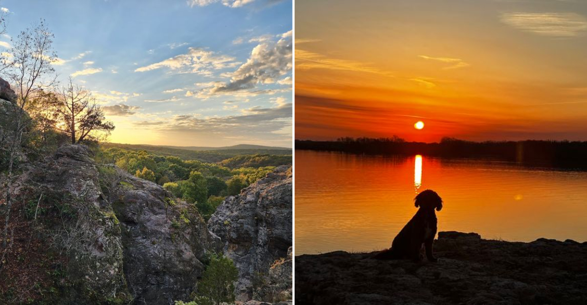
Shawnee’s Sandstone Wonderland

Running almost entirely through the Shawnee National Forest, the River to River Trail is wrapped in one of the most geologically fascinating landscapes in the American Midwest.
The forest covers roughly 289,000 acres across southern Illinois, and it looks nothing like the flat farmland most people picture when they think of this state.
Ancient sandstone bluffs, carved by millions of years of wind and water, rise dramatically above the tree canopy. Seasonal wildflowers carpet the forest floor in spring, while fall transforms the whole scene into a canvas of deep reds and burnt oranges that photographers travel far to capture.
The forest is also home to an impressive variety of wildlife. White-tailed deer, wild turkey, reptiles, amphibians, and dozens of songbird species share the land with hikers who pass quietly through.
Shawnee National Forest gives the River to River Trail its soul, and spending even a few hours inside it feels like stepping into a completely different world.
Garden Of The Gods Steals The Show

Of all the stunning landmarks along the River to River Trail, Garden of the Gods consistently stops hikers in their tracks.
Located in Saline County within the Shawnee National Forest, this geological wonder features enormous sandstone formations with names like Camel Rock, Anvil Rock, and Devil’s Smokestack that have been sculpted by erosion over hundreds of millions of years.
The overlook at Garden of the Gods offers a sweeping panoramic view of the surrounding forested valleys that genuinely earns the word breathtaking. Sunrise and sunset visits are especially popular, when warm golden light washes over the ancient rocks and the forest below glows with color.
The site is accessible via a short loop trail from the parking area, making it one of the most visited spots in the entire Shawnee National Forest.
For thru-hikers on the River to River Trail, arriving at Garden of the Gods after days of walking through the woods feels like stumbling onto something sacred and completely worth every step.
From The Ohio To The Mississippi

The name says it all. The River to River Trail links two of North America’s most iconic waterways, starting near Elizabethtown on the Ohio River and ending near Grand Tower on the Mississippi River.
This east-to-west journey across the bottom of Illinois is as symbolic as it is scenic.
Standing at either endpoint and looking out at the wide, slow-moving water feels like a natural punctuation mark to the adventure.
The Ohio River end offers quiet banks and small river towns with a welcoming, unhurried character. The Mississippi River end, near Grand Tower, features dramatic rock formations rising right out of the water, including the famous Tower Rock just offshore.
Completing the full trail means you have literally walked from one great American river to another, which is the kind of accomplishment that stays with you long after the trail dust washes off. It is a journey with a clear beginning, a clear end, and a whole lot of memorable territory in between.
Bell Smith Springs Feels Unreal

Bell Smith Springs is one of those trail sections that hikers talk about for years after their trip. Located in Pope County within the Shawnee National Forest, Bell Smith Springs is a nearby highlight of the region, featuring clear, cool water flowing through a scenic sandstone canyon.
The natural swimming holes here are a genuine reward on a hot summer day. The water stays refreshingly cool even in July, and the canyon walls create a sheltered, almost cathedral-like atmosphere that makes it hard to rush through.
Many hikers set up camp nearby just to spend extra time exploring the area.
The creek crossings at Bell Smith Springs require careful footing, especially after rain, but the payoff is absolutely worth a little wet boot situation. Arched rock formations frame the water in places, creating natural photography opportunities that look almost too good to be real.
This stretch of the trail is proof that Illinois is hiding landscapes that rival anything you might find in more celebrated hiking destinations.
Rich Native American History

Long before European settlers arrived, the land that the River to River Trail crosses was home to Indigenous peoples whose history runs deep through the soil of southern Illinois.
The trail passes near ancient earthworks, ceremonial sites, and landscapes that carry significant cultural meaning for Native American communities.
The broader region of southern Illinois was part of a vast network of Indigenous trade routes and settlements stretching back thousands of years.
Cahokia Mounds, a UNESCO World Heritage Site located farther north near Collinsville, gives broader regional context to how sophisticated and widespread Indigenous civilizations were in Illinois.
Hiking the River to River Trail with this history in mind adds a layer of meaning to every ridge walked and every creek crossed.
The forest has witnessed human presence across millennia, and pausing to reflect on that while standing at a quiet overlook or beside an ancient rock formation creates a connection to place that goes far beyond a simple outdoor workout. History here is not in a museum but under your feet.
Where The Forest Comes Alive

Hiking the River to River Trail means sharing the landscape with a remarkable variety of animals. White-tailed deer are common trail companions, often spotted grazing in meadow clearings during early morning hours.
Wild turkeys are frequently seen strutting through the understory, seemingly unimpressed by passing hikers.
Birdwatchers will find the trail especially rewarding. The Shawnee National Forest sits within a major migratory flyway, meaning spring and fall hikes bring an impressive parade of warblers, tanagers, and raptors through the canopy.
Pileated woodpeckers announce themselves loudly from the treetops, and great blue herons stand motionless along creek banks.
Copperhead snakes are present in the area and worth a respectful awareness, particularly when stepping over logs or rocks in warmer months.
Watching where you place your hands and feet is standard good practice in this kind of terrain. Overall, the wildlife presence along this trail makes every outing feel genuinely alive, like the forest is actively participating in the journey alongside you.
Best Seasons To Hike

Spring and fall are widely considered the ideal seasons for hiking the River to River Trail. April and May bring an explosion of wildflowers, comfortable temperatures, and lively birdsong that makes every mile feel celebratory.
The forest is at its most photogenic in October and early November, when the hardwood canopy turns into a rolling tapestry of color.
Summer hiking is absolutely possible but comes with heat, humidity, and a significant increase in insect activity. Ticks are a real concern from late spring through early fall, so wearing long sleeves, using insect repellent, and checking yourself thoroughly each evening is essential trail hygiene in this region.
Winter offers a surprisingly peaceful experience for prepared hikers. The bare trees open up long views through the forest, and the sandstone formations look especially dramatic against a gray winter sky.
Trail traffic drops significantly in colder months, giving solo hikers a level of quiet solitude that is genuinely hard to find elsewhere in the region. Plan your season carefully and the trail will reward you generously.
Before You Hit The Trail

Proper planning makes a significant difference on a trail this long and remote. Water sources exist along the route, but a reliable filtration system is non-negotiable since many natural water sources require treatment before drinking.
Carrying at least two to three liters of water capacity is a smart baseline for any section of this trail.
The River to River Trail Association maintains the path and publishes detailed maps and guidebooks that are worth purchasing before you set out.
Cell service is unreliable through much of the Shawnee National Forest, so downloading offline maps or carrying a paper version is strongly recommended.
Camping along the trail is generally allowed on National Forest land, but some specific areas have designated sites or restrictions, so checking current regulations before your trip avoids surprises.
The nearest towns for resupply include Harrisburg and Elizabethtown, both of which offer basic amenities. Starting with a shorter section of the trail is a great way to get a feel for the terrain before committing to the full 160-mile journey.