13 Colorado Places That Look Like They Belong In Another State
Ask Colorado for mountains, and it may answer with badlands, sand-colored cliffs, wind-carved gullies, and canyons that look borrowed from another map. That is what makes these overlooked landscapes so much fun: they scramble the picture most people carry in their heads.
Forget the usual vision of ski runs, pine forests, and snow-capped summits for a minute, because the state has entire corners that feel sunbaked, strange, ancient, and wildly cinematic. One road can trade alpine drama for painted earth, dry washes, sculpted rock, and horizons so wide they make your phone camera feel useless.
The surprise is not that these places are beautiful. The surprise is how completely they rewrite the mood of the trip.
Colorado’s most unexpected scenery proves that a state can be famous for one kind of beauty and still keep its weirdest, wildest chapters hiding in plain sight.
1. Pawnee Buttes near Grover, Northeast Colorado

Standing out on the Pawnee Buttes trailhead, you get the eerie feeling that someone quietly relocated a chunk of South Dakota’s badlands into Colorado without telling anyone. Two isolated sandstone sentinels rise roughly 300 feet above the surrounding prairie, and the flatness stretching in every direction makes them look even more theatrical.
There is nothing else like this in the state.
The Forest Service maintains a 2-mile trail out to the first butte, and the walk itself is refreshingly flat and manageable. No mountain legs required.
Just good shoes, a water bottle, and a willingness to feel pleasantly small against an enormous sky.
One important note: seasonal nesting closures run from March 1 through June 30 around certain areas, so plan accordingly if you want full access. Early morning visits in late summer or fall reward you with cool temperatures and soft prairie light that photographers dream about.
Grover is a tiny town, so fuel up before you head out. There are no crowds, no entrance fees, and no cell service to distract you.
Just wind, grass, and two ancient buttes doing their quiet, impressive thing on the Colorado plains.
2. Paint Mines Interpretive Park, Calhan

Somewhere between Calhan and disbelief, you stumble into a landscape that looks like Utah shrunk itself down and moved to the Colorado plains. The Paint Mines Interpretive Park delivers pastel clay bands, hoodoos, spires, and eroded gullies across 750 stunning acres, and it costs exactly nothing to visit.
El Paso County keeps the park open year-round from dawn to dusk, which means even a spontaneous Tuesday afternoon works perfectly.
Four miles of trails wind through the formations, and interpretive signage explains the geology without making you feel like you are studying for an exam. The colors shift throughout the day, going from soft peach in the morning to deep coral by late afternoon.
Bring a wide-angle camera lens if you have one, because the scale here rewards it.
One firm rule worth repeating: stay off the formations. The clay is fragile, and footprints cause permanent damage that takes thousands of years to undo.
Restrooms are available on-site, which is a welcome detail for families with young kids. Morning visits tend to offer the best light and the fewest other visitors.
This is the kind of place that makes Colorado feel genuinely mysterious, even to lifelong residents who thought they had seen it all.
3. Picket Wire Canyonlands, Comanche National Grassland near La Junta

Forget everything you associate with Colorado for a moment. Picket Wire Canyonlands, tucked into the Comanche National Grassland near La Junta, looks and feels like it belongs somewhere in New Mexico or the Texas Panhandle.
Canyon walls, dry grasslands, and a remote river corridor create a scene that is rugged, raw, and genuinely unforgettable.
The star attraction here is extraordinary: the largest dinosaur tracksite in North America, with more than 1,900 prints spread across 130 trackways. Walking alongside those tracks is one of those rare travel moments that stops conversation cold.
You stand there quietly, and history does all the talking.
Access is either a long 11.2-mile round-trip hike or a reserved guided auto tour on select Saturdays, and the Forest Service handles reservations for those drives. Neither option is quick, but both are worth every minute.
Bring more water than you think you need, because southeastern Colorado heat is not subtle in summer. Fall visits are ideal for comfortable temperatures and uncrowded trails.
This is not a place for quick selfie stops; it rewards people who arrive prepared to slow down, look carefully, and appreciate a corner of Colorado that most residents have never seen and absolutely should.
4. Picture Canyon, Comanche National Grassland, Baca County

Way down in Baca County, closer to Oklahoma and New Mexico than to Denver, Picture Canyon makes a convincing case that Colorado has a secret southwestern soul.
Sandstone canyon walls, open prairie horizons, ancient rock imagery, and crumbling homestead remnants create a layered landscape that feels like it belongs in a different state entirely.
The Forest Service actively maintains a recreation page for the site and takes its fragile cultural resources seriously.
Thirteen miles of hiking and horseback trails wind through the canyon and surrounding terrain, offering plenty of room to explore without feeling rushed or crowded. The rock art here is genuinely ancient, and the signage encourages respectful observation from a distance.
No touching, no tracing, no shortcuts around the rules.
Visiting Picture Canyon takes commitment since Baca County is remote, and the nearest services require planning ahead. That remoteness is also exactly what makes it special.
You are unlikely to share the canyon with more than a handful of other visitors on any given day. The sense of solitude out here is profound and a little humbling.
Pair a morning at Picture Canyon with a slow drive back through the grasslands, and you have the kind of off-the-beaten-path Colorado day that most people never even know exists.
5. Penitente Canyon, near La Garita, San Luis Valley

Red rock walls, high desert scrub, and a quiet canyon atmosphere that carries a distinctly New Mexico energy: Penitente Canyon near La Garita is one of Colorado’s most surprising identity tricks. The BLM lists it as an active recreation area with nearly 300 technical climbing routes, and the rock quality draws climbers from across the region.
But you do not need to be a climber to appreciate what is here.
Hiking, biking, horseback riding, fishing, and camping are all available, and rock art adds a cultural layer that makes the canyon feel genuinely ancient. The campground is open year-round, with water available seasonally from May through October.
That seasonal detail matters if you are planning a shoulder-season trip and want running water at the site.
The San Luis Valley itself is one of Colorado’s most underrated regions, and Penitente Canyon fits right into that theme. The valley floor is flat, wide, and surrounded by distant mountain ranges in a way that feels almost theatrical.
Arriving at the canyon after crossing that open valley floor gives you a satisfying sense of discovery. Go in late afternoon when the red rock catches warm light, find a flat boulder to sit on, and let the canyon do what it does best: make you feel like you wandered into a completely different state.
6. Zapata Falls Recreation Area, near Mosca, San Luis Valley

Here is a scene that does not quite compute at first glance: a 25-foot waterfall hiding inside a narrow rock cleft, with sweeping views of sand dunes and high desert valley stretching out below. Zapata Falls Recreation Area near Mosca is one of those places that earns a genuinely surprised reaction every single time.
The BLM lists it as a no-fee day-use site, which makes the surprise even better.
The hike to the waterfall is short but slippery, involving a wade through cold, shallow water inside the canyon slot. Waterproof shoes or sandals you do not mind soaking are the right call here.
The payoff is a cool, echoing chamber with a waterfall that feels completely out of place in the surrounding desert, which is precisely why it is so memorable.
The campground is open year-round with toilets, trash service, and trailheads, and the views toward Great Sand Dunes and the San Luis Valley are reason enough to linger well past the waterfall visit. The whole scene has a New Mexico high desert quality that catches visitors off guard.
Morning visits keep the hike cooler and the parking manageable. Bring a dry bag for your phone, wear shoes you can soak, and plan to stay longer than you originally intended.
You almost certainly will.
7. Wheeler Geologic Area, near Creede

Wheeler Geologic Area near Creede looks like Bryce Canyon took a wrong turn and ended up in southern Colorado without telling anyone. Eroded volcanic tuff formations rise in pale, spindly columns that create a genuinely otherworldly skyline.
The Forest Service describes access by either a 7-mile hike or a rough 14-mile four-wheel-drive road, and both options are honest about the effort required.
High-clearance 4×4 vehicles or ATVs are strongly recommended for the road approach, and monsoon storms can turn that road into a genuinely bad idea with very little warning. Timing matters here.
Midsummer afternoon visits carry storm risk, so aim for morning departures and keep an eye on the sky throughout the day.
The reward for all that effort is remarkable solitude and a landscape that looks like it should have tour buses circling it but somehow does not. Wheeler remains one of Colorado’s quieter geological wonders precisely because getting there requires real commitment.
That keeps the crowds away and gives the place a raw, unpolished quality that feels increasingly rare. If you hike in rather than drive, the 7-mile approach through the Rio Grande National Forest is beautiful in its own right.
Pack a lunch, wear layers, and plan for a full day. Wheeler does not do quick visits.
8. Garden Park Fossil Area, north of Canon City

Garden Park Fossil Area sits north of Canon City along Shelf Road, and the moment you arrive, the landscape starts whispering Utah. The dry canyon terrain, eroded bluffs, and fossil-rich geology have more in common with Dinosaur Country in the Beehive State than with Colorado’s mountain reputation.
The BLM designates this as an Area of Critical Environmental Concern, a Colorado Research Natural Area, and a National Natural Landmark, which is a remarkable triple distinction for a place many Coloradans have never visited.
Hiking, wildlife viewing, scenic driving, and marked interpretive pullouts are all available here, making it accessible for visitors with varying energy levels. The interpretive signage along the route does a solid job connecting the landscape to its paleontological significance without overwhelming you with jargon.
Some of the most famous dinosaur discoveries in history, including early Allosaurus and Stegosaurus specimens, came from this ground.
Spring and fall are ideal visiting seasons, when temperatures are comfortable and the canyon light is at its most dramatic. Summer works too, but bring serious sun protection because shade is scarce.
The drive along Shelf Road itself is scenic and a bit adventurous, threading through canyon terrain that rewards slow, attentive driving. Garden Park is the kind of place that quietly outperforms expectations every single time someone bothers to make the trip.
9. Gunnison Gorge National Conservation Area, near Montrose and Delta

Adobe badlands, pinyon-juniper hillsides, black granite walls, and red sandstone cliffs: the Gunnison Gorge National Conservation Area near Montrose and Delta is a landscape that feels borrowed from Utah and quietly installed in western Colorado. The BLM manages 62,844 acres here, and the terrain ranges from open badlands on the upper rim to a rugged double canyon carved deep by the Gunnison River far below.
Fishing and whitewater boating are the headline activities for many visitors, and the Gunnison River earns its reputation as one of Colorado’s premier fisheries. But the scenery alone justifies the drive even if you never touch the water.
The canyon walls create a visual drama that changes character completely depending on the time of day and the angle of the light.
Access to the inner gorge requires serious hiking on steep, unmaintained trails, so check conditions before committing to a canyon descent. The upper rim areas are far more accessible and still deliver sweeping views that make the trip worthwhile.
Fall is particularly good here, when the pinyon and juniper catch warm tones and the river crowds thin considerably. Montrose is a comfortable base with good food options, making it easy to pair a Gunnison Gorge morning with an afternoon exploring the broader region.
10. Dominguez-Escalante National Conservation Area, Delta and Grand Junction Region

Red-rock canyons, sandstone bluffs, desert bighorn habitat, and the Gunnison River weaving through it all: the Dominguez-Escalante National Conservation Area near Delta and Grand Junction is the kind of place that makes visitors reach for their phone to double-check they are still in Colorado. The resemblance to southern Utah is not subtle.
It is persistent, convincing, and genuinely thrilling.
The BLM lists the NCA as active for hiking, boating, camping, wildlife viewing, photography, horseback riding, and heritage tourism. Big Dominguez and Potholes campgrounds offer overnight options for those who want more than a day trip, and both sit within striking distance of excellent canyon scenery.
The river corridor adds a lush contrast to the surrounding desert terrain that keeps the landscape visually interesting throughout any visit.
Wildlife sightings here are legitimately common, with desert bighorn sheep frequently spotted on the canyon walls. Bring binoculars and patience, and you will likely be rewarded.
Spring and fall offer the most comfortable temperatures for hiking and paddling, while summer mornings work well if you start early and respect the heat by midday.
The heritage tourism angle adds another layer, with ancient cultural sites scattered through the landscape for those willing to look carefully and tread respectfully.
11. Rattlesnake and Mee Canyons, McInnis Canyons NCA near Fruita

Rattlesnake and Mee Canyons near Fruita might be the most convincingly Utah-looking places in the entire state of Colorado. Natural arches, spires, windows, alcoves, desert patina, and pinyon-juniper mesas combine into a landscape that would fit seamlessly into Arches National Park’s neighborhood.
The BLM lists both canyons for hiking and photography, and the visual payoff is extraordinary for those willing to do the work to reach them.
High-clearance or 4WD vehicles are needed for access, and seasonal motorized-access windows apply, so checking current conditions before you go is genuinely important rather than optional. Wet roads can make access impossible, and the day-use-only rules at the trailhead mean overnight camping is not an option.
Plan accordingly and you will be fine.
Rattlesnake Canyon in particular is said to contain the second-highest concentration of natural arches in the United States after Arches National Park, which is a staggering fact that somehow most people outside the region have never heard.
Early morning visits reward you with soft light on the sandstone and a canyon that feels entirely yours for at least an hour or two.
Fruita is a lively little town with excellent food and mountain biking culture, making it an ideal base for a full weekend that combines canyon exploration with some well-earned post-hike tacos.
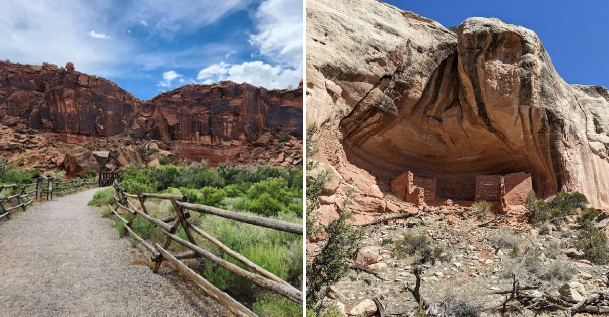
12. Canyons of the Ancients National Monument, near Cortez and Dolores

High-desert mesas, crumbling pueblos, kivas, cliff dwellings, petroglyphs, and ancient road systems: Canyons of the Ancients National Monument near Cortez and Dolores delivers a cultural and landscape experience that feels unmistakably like Arizona or New Mexico.
The BLM manages 176,000 acres here and has documented more than 8,300 cultural sites within the monument boundary, which is the highest known density of archaeological sites in the United States.
Scenic driving, hiking, horseback riding, camping, hunting, biking on designated routes, and cultural-site visits are all available, giving visitors a remarkable range of ways to experience the monument. The sheer scale of the place means you can return multiple times and still discover something new.
A single visit barely scratches the surface.
The Anasazi Heritage Center near Dolores serves as the monument’s visitor center and is an excellent first stop for context and orientation before heading into the field. Cortez is the practical base for the region, with lodging, restaurants, and gear shops.
Spring and fall are the prime seasons, offering comfortable temperatures and uncrowded trails. Summer mornings work if you start early and carry plenty of water.
This corner of Colorado sits at the heart of the ancient Southwest, and the monument makes that heritage feel immediate, tangible, and genuinely moving in a way that photographs simply cannot prepare you for.
13. Harpers Corner and Echo Park, Dinosaur National Monument, Far Northwest Colorado

Harpers Corner and Echo Park sit inside Dinosaur National Monument, and the Colorado side of that park is one of the state’s best-kept geographic secrets. Deep river canyons carved by the Green and Yampa rivers, towering sandstone walls, remote desert roads, and canyon overlooks that stop you cold: this landscape reads as Utah and Wyoming, not Colorado.
The NPS confirms that Harpers Corner Road, Echo Park Road, and several Colorado-side trails are currently open.
Echo Park itself is a legendary destination among river runners and canyon enthusiasts, sitting at the confluence of the Green and Yampa rivers beneath enormous sandstone walls. Getting there requires a long, winding dirt road that demands high-clearance vehicles and dry conditions.
When wet, the road becomes impassable, so checking current conditions with the park before departure is non-negotiable.
Harpers Corner offers a paved road option with a 2-mile round-trip trail to one of the most dramatic canyon overlooks in the entire national park system. The view from the end of that trail is genuinely jaw-dropping, with canyon arms spreading in multiple directions below you.
Campgrounds on the Colorado side provide overnight options for those who want to experience the canyon at dawn or dusk. Far from everything, quiet, and visually stunning, this corner of Colorado rewards every mile of the long drive it takes to reach it.