12 Arizona Rail Trails Where Desert Views Make Every Mile Worth Pedaling
Look, I’ll be the first to admit that my cardio game is usually limited to sprinting after the ice cream truck. But there is something about the Arizona desert that makes me want to actually strap on a helmet and pretend I’m an athlete.
If you’re like me and prefer your bike rides with a side of “wow, look at that cactus” rather than “my lungs are actively collapsing,” then you’re in the right place.
I’ve rounded up the best rail trails where the terrain is smooth, the scenery is cinematic, and the only thing you have to worry about is dodging a particularly judgmental lizard.
Grab your water bottle, seriously, bring way more than you think you need, and let’s get those pedals moving.
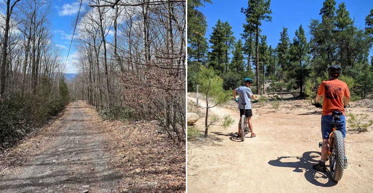
1. Prescott Peavine National Recreation Trail, Prescott

Few trails in Arizona open with as dramatic a statement as this one does. The Prescott Peavine National Recreation Trail follows the historic Santa Fe, Prescott and Phoenix Railway corridor through rugged terrain just north of downtown Prescott, Arizona.
The path stretches roughly 10 miles and sits at an elevation of around 5,000 feet, giving riders a welcome break from lowland heat. Granite Dells, a surreal cluster of rounded pink and gray boulders, frames long stretches of the trail and creates scenery that feels almost otherworldly.
Watson Lake appears along the route, and stopping to watch kayakers glide across its glassy surface is a perfectly good reason to slow your pace. The surface is mostly packed gravel and crushed rock, making it friendly for hybrid bikes.
Spring and fall are the sweet spots for visiting, when temperatures stay comfortable and wildflowers add color to the rocky landscape.
2. Iron King Trail, Prescott Valley

Connecting two communities with a smooth, paved surface, the Iron King Trail runs about 6.5 miles between Prescott Valley and Dewey-Humboldt in central Arizona.
Named after the Iron King Mine that once operated nearby, this trail carries a quiet sense of industrial history beneath its peaceful, park-like atmosphere. Interpretive signs along the route share stories about the mining era that shaped this corner of Yavapai County.
The terrain is mostly flat, which makes it a top pick for families with young riders or anyone who wants a low-pressure outing without big elevation changes. Surrounding views include rolling grasslands, scattered juniper, and the long ridgeline of Mingus Mountain to the south.
Mornings on this trail feel calm and uncrowded, with birdsong often the only sound you hear. Parking is available at both ends, so out-and-back rides or car shuttles are both easy to arrange.
3. Chino Valley Peavine Trail, Chino Valley

Stretching through the broad, open basin north of Prescott, the Chino Valley Peavine Trail covers some of the most quietly beautiful terrain in northern Arizona.
This segment of the historic Peavine railroad corridor runs through high desert grasslands where pronghorn antelope occasionally graze just off the trail edge. Riders who keep their eyes open and their speed moderate are regularly rewarded with wildlife sightings that no zoo could replicate.
The trail surface is natural and unpaved, so a mountain bike or gravel bike handles it best. At roughly 4,800 feet in elevation, temperatures stay mild even during summer mornings, though afternoon thunderstorms are common from July through September.
The surrounding landscape feels wide and unhurried, with distant mountain ranges visible in nearly every direction. Local riders often use this trail for longer weekend loops that connect with other segments of the Peavine corridor, making it a versatile starting point.
4. Iron Springs Railroad Trail, Prescott National Forest

Inside Prescott National Forest west of the city of Prescott, the Iron Springs Railroad Trail follows an old logging railroad grade through a canopy of ponderosa pine and Gambel oak. The shaded corridor makes this trail a summer favorite when exposed desert trails become uncomfortably hot.
Riding here feels like stepping into a completely different Arizona, one defined by cool air, pine needles, and the occasional sound of a woodpecker overhead.
The trail is unpaved and requires a mountain or gravel bike, but the grade is gentle thanks to its railroad origins, which kept slopes minimal for heavy freight loads.
History enthusiasts will appreciate knowing that this route once hauled timber to support growing communities in the region during the late 1800s and early 1900s.
The trailhead is accessible from Iron Springs Road, and the surrounding forest offers additional trails for those who want to extend their day into a longer backcountry adventure.
5. Railroad Grade Trail, White Mountains / Big Lake Area

Up in the cool, high-elevation world of the White Mountains near Big Lake, the Railroad Grade Trail traces a historic logging railroad that once moved timber through one of Arizona’s most lush and remote landscapes.
Sitting above 9,000 feet, this trail offers a riding experience that feels more Colorado than Arizona, with spruce-fir forests, wildflower meadows, and crisp mountain air that makes every breath feel refreshing.
The route is remote, so riders should come prepared with water, snacks, and a good map, as cell service is unreliable in this area.
Summer is the prime season, roughly June through early October, since snow can linger well into spring at this elevation.
Big Lake itself is visible from parts of the trail, and its mirror-like surface reflecting the surrounding forest is one of those views that genuinely stops you in your tracks. This trail rewards those willing to make the drive east.
6. Indian Springs Trail, Apache-Sitgreaves National Forests

The Apache-Sitgreaves National Forests cover nearly two million acres across eastern Arizona, and the Indian Springs Trail offers one of the more rewarding ways to explore this massive and underappreciated wilderness.
Following an old railroad grade, the trail moves through mixed conifer forest with sections that open onto grassy meadows where elk tracks are often visible in soft soil near the path edges.
Riders who appreciate solitude will find it here. Trailhead crowds are minimal compared to more famous Arizona destinations, and the pace of life in this part of the state is refreshingly unhurried.
The trail surface is natural dirt, best suited to mountain bikes with moderate tire width. Afternoon thunderstorms are a regular occurrence during monsoon season, so early morning starts are smart planning from July through September.
The surrounding national forest also offers campgrounds, making this an ideal destination for a multi-day biking and camping trip.
7. Route 66 Trail, Flagstaff

Flagstaff sits at 7,000 feet, which means riding the Route 66 Trail comes with scenery that most people do not expect from an urban bike path.
The trail runs along the historic Route 66 corridor through the city, connecting neighborhoods while offering views of the San Francisco Peaks rising dramatically to the north.
Those volcanic peaks, topped with snow for much of the year, create a backdrop that turns an ordinary city ride into something genuinely scenic.
The path is paved and accessible to riders of all skill levels, including families with kids on balance bikes or trailers. Along the way, riders pass vintage motels, local diners, and murals celebrating the Mother Road’s colorful history.
Flagstaff’s compact downtown is easy to access from the trail, making mid-ride coffee stops a natural part of the experience. Fall is particularly striking here, when aspens in the surrounding mountains turn gold and the air carries a sharp, pleasant chill.
8. Sinclair Wash Trail, Flagstaff

Not every great trail announces itself loudly, and Sinclair Wash Trail in Flagstaff, Arizona, is proof that understated routes can be just as satisfying as famous ones.
Running along a natural drainage corridor through ponderosa pine forest on the south side of the city, this trail follows an old railroad grade that once supported logging operations in the region. The gentle, consistent grade makes it an easy pedal with just enough length to feel like a real workout.
Local riders use Sinclair Wash as a connector trail linking different parts of Flagstaff’s growing trail network, which means you can turn a short out-and-back into a much longer loop with some creative route planning.
Wildlife sightings, including mule deer and wild turkey, are common along this forested corridor. The proximity to downtown Flagstaff makes it accessible without a long drive, and the shaded canopy keeps temperatures comfortable even on warmer summer afternoons.
9. Yuma Crossing Bike Path, Yuma

Yuma, Arizona, sits at the confluence of the Colorado and Gila Rivers, and the Yuma Crossing Bike Path takes full advantage of that geography.
Following a historic railroad and river crossing corridor, this paved path winds through the Yuma Crossing National Heritage Area, where interpretive panels share stories of the steamboat era, military outposts, and the gold rush travelers who crossed here in the mid-1800s.
The terrain is pancake flat, which makes this trail perfect for casual riders, older cyclists, or anyone recovering from an injury who still wants fresh air and forward motion.
Cottonwood trees and native riparian vegetation line sections of the path, creating a green, shaded corridor that feels like a cool oasis in one of the hottest cities in the country.
Winter is the golden season for visiting Yuma, when snowbirds flock to the area and daytime temperatures hover in the comfortable mid-70s Fahrenheit range.
10. Patagonia Train Track Trail, Patagonia

Southern Arizona’s wine country and birding paradise, the small town of Patagonia sits in a lush valley surrounded by rolling grasslands and oak-studded hills.
The Patagonia Train Track Trail follows the old Nogales branch railroad bed through this valley, offering riders a flat, easy route with surprisingly rich scenery for a desert region.
Birders especially love this corridor, as the riparian habitat near Sonoita Creek supports an extraordinary variety of bird species year-round. The trail surface is natural and unpaved, keeping things quiet and free from heavy recreational traffic.
Riders can connect their outing with a visit to the Patagonia-Sonoita Creek Preserve, managed by The Nature Conservancy, where towering Fremont cottonwoods create cathedral-like shade along the water’s edge.
Spring migration season, roughly April and May, draws nature enthusiasts from across the country to this area. Patagonia’s small-town charm, with local cafes and art galleries nearby, makes the post-ride experience just as enjoyable as the ride itself.
11. El Paso And Southwestern Greenway, Tucson

Tucson’s El Paso and Southwestern Greenway follows the bed of the historic EP&SW Railroad through the heart of one of Arizona’s most vibrant cities.
The paved path connects several Tucson neighborhoods while passing through landscapes dotted with saguaro cacti, creosote, and palo verde trees that bloom brilliant yellow each spring.
It is the kind of urban trail that reminds you how much personality a city can pack into a converted rail corridor. The greenway links to Tucson’s broader network of paved shared-use paths, so riders can extend their journey significantly without touching a car lane.
Local murals and public art installations appear along the route, giving the trail a cultural dimension that purely scenic paths often lack.
Tucson’s mild winters make this a year-round cycling destination, and the flat grade keeps the experience accessible regardless of fitness level. Mountain views, particularly toward the Santa Catalinas to the north, provide a constant and stunning visual anchor throughout the ride.
12. Mohave And Milltown Railroad Trail, Mojave Valley / Oatman Area

Out near the California border in the far northwestern corner of Arizona, the Mohave and Milltown Railroad Trail cuts through some of the rawest, most cinematic desert terrain in the entire state.
The trail follows the bed of a narrow-gauge railroad that once served gold mining operations in the Black Mountains near the historic town of Oatman, where wild burros still roam the streets freely today.
This trail is not for the faint of heart in terms of heat management. Summer temperatures in the Mojave Valley regularly exceed 110 degrees Fahrenheit, so October through March is the only sensible riding window for most people.
The payoff for timing your visit correctly is spectacular: jagged volcanic peaks, wide desert flats, and a sense of riding through a landscape almost entirely unchanged since the mining days. Oatman itself is worth a post-ride wander, with its Route 66 character and surprisingly good roadside food options.