12 Best Hiking Trails In Utah To Explore In 2026
Red rock canyons, alpine peaks, and slot canyons packed with waterfalls keep showing up on bucket lists for good reason, and Utah is the state that strings all of that together into one nonstop outdoor playground.
Whether you are chasing sunrise views from towering arches or wading through rivers between canyon walls, the trails here offer something wild and memorable around every bend.
The best part is that you do not need to be a professional mountaineer to enjoy most of these routes, just a solid pair of boots and a willingness to sweat a little.
1. Angels Landing: Zion National Park, Springdale, Utah
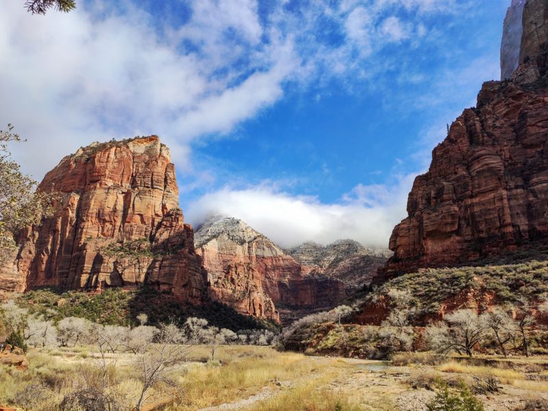
There are hikes that make you feel accomplished, and then there is Angels Landing, which makes you feel like you negotiated a truce between your legs and your nerves.
The first time I climbed through Refrigerator Canyon and up the tight Walters Wiggles switchbacks I pretended to stop for photos even though I mostly wanted a polite excuse to breathe.
This route is roughly five and a half miles round trip with more than one thousand feet of elevation gain, finishing on a narrow sandstone fin with chain handholds and huge views of Zion Canyon.
The hike begins from the Grotto area in Zion National Park, reached by shuttle from the Zion Canyon Visitor Center near 1 Zion Park Boulevard, Springdale, Utah 84767.
Because of heavy use and serious exposure along the upper ridge, the park now requires a lottery permit for the chain section, a system that continues into 2025 and is expected to remain similar in 2026, so planning ahead is part of the adventure.
I like to tell nervous friends that even stopping at Scout Lookout still delivers a canyon panorama grand enough to count the hike as a win before heading back down.
2. The Narrows via Riverside Walk: Zion National Park, Springdale, Utah
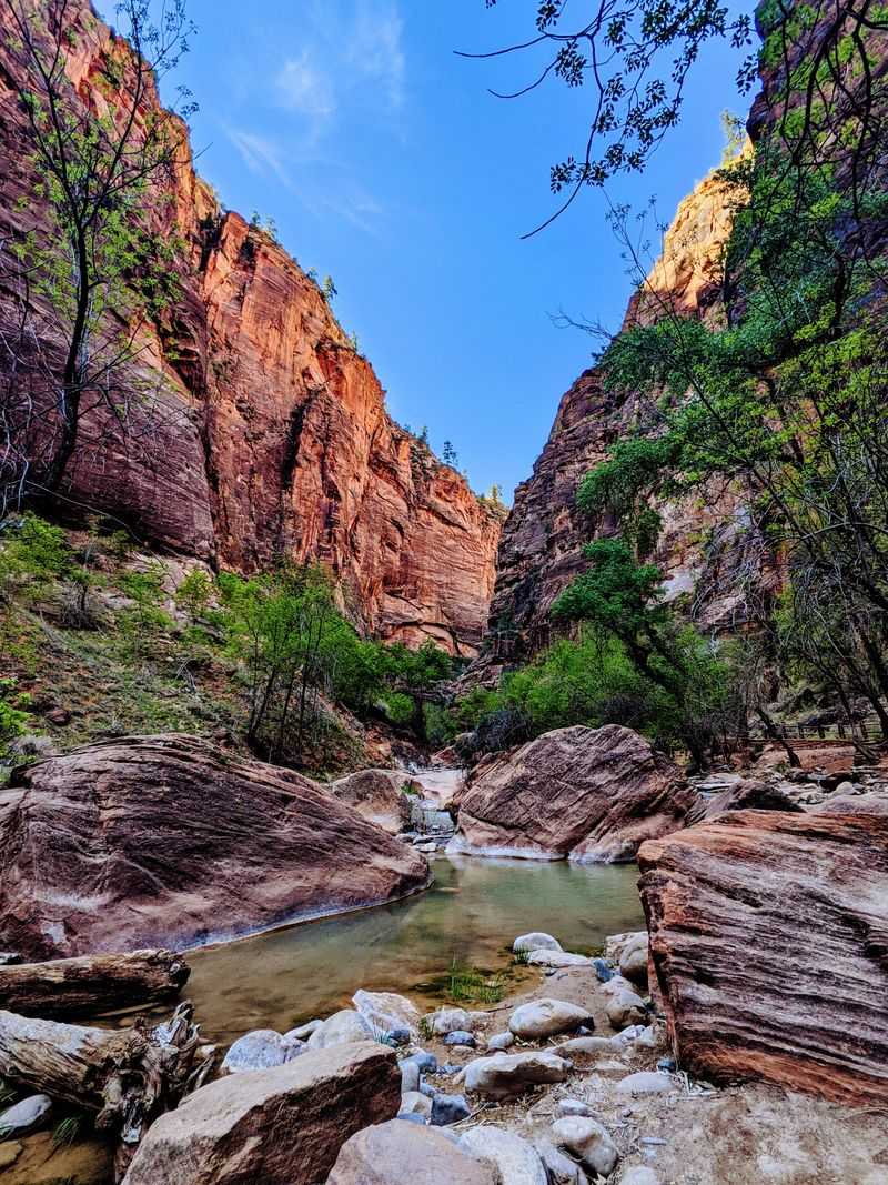
Nothing makes you feel more committed to a hike than realizing the trail is actually the river you are standing in.
I still remember stepping into the Virgin River for the first time, watching hikers ahead of me wobble on submerged rocks while I quietly negotiated with my ankles.
Most people tackle the Narrows from the bottom up, following Riverside Walk from the Temple of Sinawava and then wading upstream between towering canyon walls, turning around whenever time or water depth says they should.
You reach the starting point by taking the park shuttle to the Temple of Sinawava in Zion National Park, which is accessed from Zion Canyon Visitor Center near 1 Zion Park Boulevard, Springdale, Utah 84767.
Park rangers monitor river flow and will close the hike when conditions are unsafe, so checking current forecasts and the flow report has become part of my pre-hike ritual.
On cooler shoulder season days in 2026, this slot of water and stone will still feel like Utah’s most refreshing hallway walk, especially if you bring dry socks waiting back in the car.
3. Canyon Overlook Trail: Zion National Park, East Side, Utah
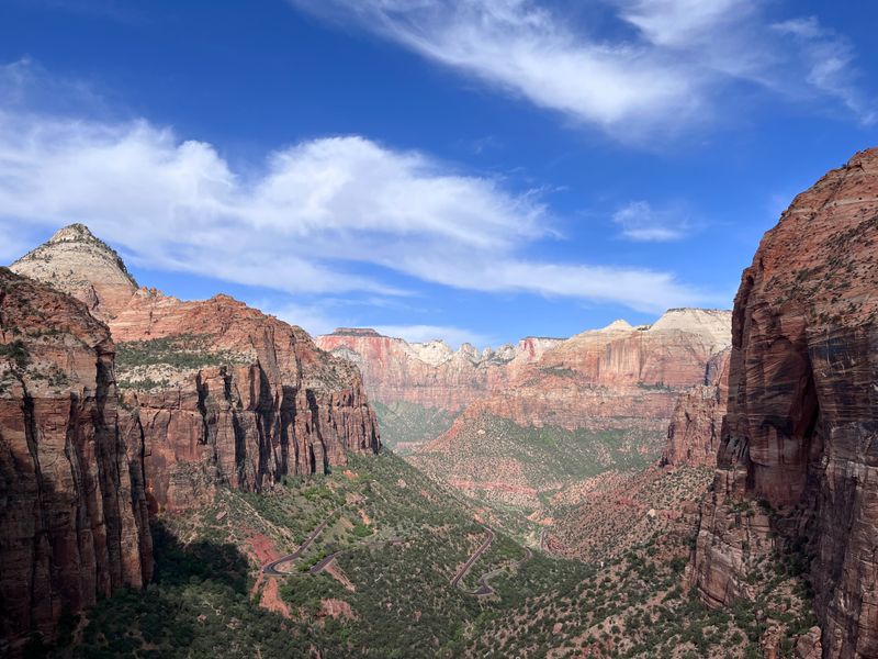
Some viewpoints make you work all day for a payoff, but Canyon Overlook hands you a postcard scene after a relatively short climb.
The first time I squeezed along its rock ledges, I kept grinning at the mix of easy sections and brief airy stretches that feel exciting without demanding expert skills.
This out-and-back route is about one mile long with modest elevation gain, delivering a ledge high above the Great Arch and lower Zion Canyon, where sunrise paints every wall in layers of orange and gold.
The trailhead sits just east of the Zion Mount Carmel Tunnel along Utah State Route 9 on the east side of Zion National Park, reached from the park’s main entrance at 1 Zion Park Boulevard, Springdale, Utah 84767.
Parking is limited near the tunnel, so I like to treat scoring a spot as the first small victory of the outing before wandering to the overlook itself.
On a clear evening, the last light over the canyon feels so good that I always stall for one more photo even after I have already taken twenty.
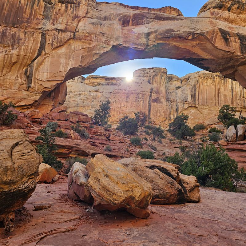
4. Delicate Arch Trail: Arches National Park, near Moab, Utah
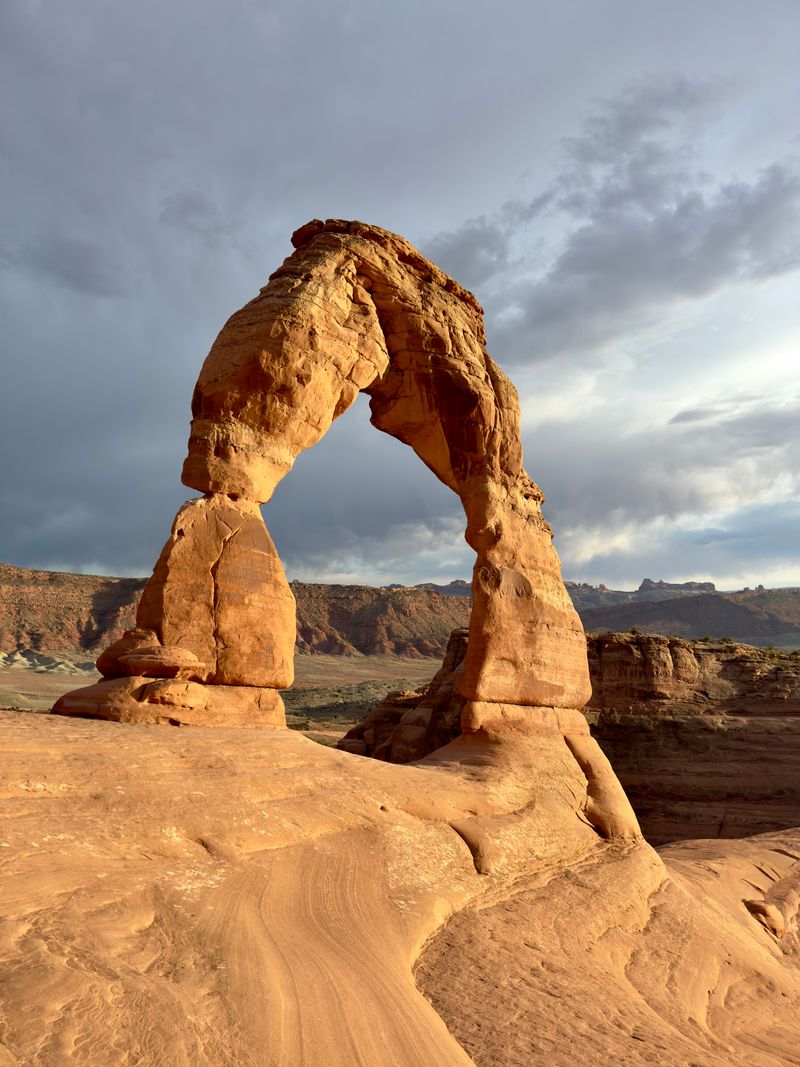
There is a moment on the Delicate Arch trail when the rock wall suddenly drops away, and the famous arch appears, and every time I watch, the entire crowd collectively forgets how tired their legs feel.
The path climbs steadily across slickrock for roughly three miles round trip with a moderate elevation gain, weaving past cairns and finishing along a short ledge that opens into a sandstone bowl framing the arch like a sculpture gallery.
The hike begins at the Wolfe Ranch trailhead inside Arches National Park, whose mailing address is P O Box 907, Moab, Utah 84532, a detail worth noting when you are plugging directions into your map for a 2026 visit.
Because Arches now uses a timed entry system during busy months, I like to reserve an early morning slot, which makes the climb cooler and gives the arch a softer light before the midday crowds settle in.
When the sun finally dips low, and the bowl falls quiet for a moment, it feels natural to linger longer than you planned before following the same slickrock back to the trailhead.
5. Devils Garden Loop: Arches National Park, near Moab, Utah
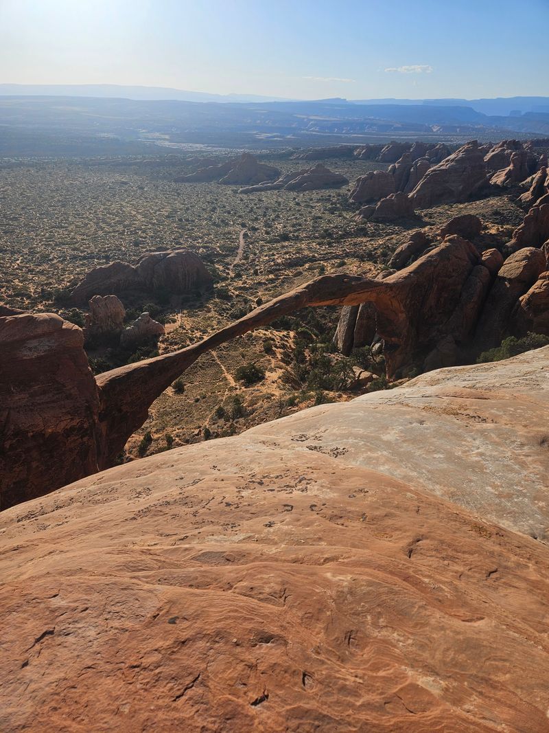
If you want a trail that keeps revealing new sandstone surprises every hour, Devils Garden is the route that never runs out of party tricks.
On my first loop here, I kept promising myself I would turn around at the next arch and then breaking that promise as soon as I saw the one after it.
The full loop can stretch to around seven miles with side trips, passing Landscape Arch, Double O Arch, and several smaller spans while alternating between well-defined paths and short slickrock scrambles.
You start from the Devils Garden Trailhead at the far end of the Arches Scenic Drive inside Arches National Park, which uses the park mailing address P O Box 907, Moab, Utah 84532 for navigation and information.
Summer heat can feel intense, so I treat this hike as a sunrise mission with plenty of water, snacks, and a flexible plan to shorten the route if the group starts fading.
However far I go, the combination of quiet corners and giant arches always leaves me scrolling through photos later and trying to decide which formation impressed me the most.
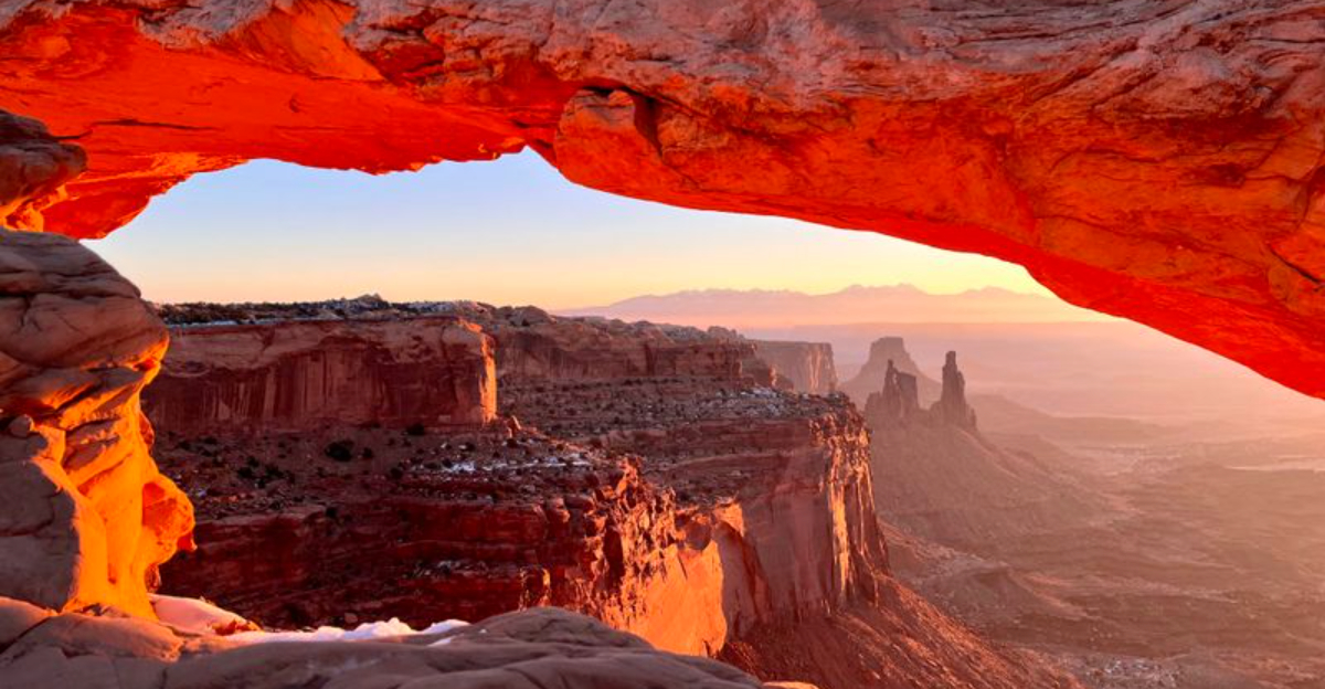
6. Mesa Arch Trail: Canyonlands National Park, Island in the Sky, Utah
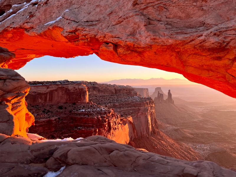
Some sunrises are pretty, and then there is the one that pours straight through Mesa Arch and makes the whole canyon system glow.
The morning I finally caught it, I arrived in the dark with a headlamp and a thermos, joined a quiet line of tripods, and listened to everyone whisper as if we were in an outdoor cathedral.
The trail itself is pleasantly short, about half a mile round trip with minimal elevation gain, looping from the parking lot to the cliff edge where the arch sits perched above an enormous drop and distant buttes.
Mesa Arch is in the Island in the Sky district of Canyonlands National Park, whose mailing address is 2282 Resource Boulevard, Moab, Utah 84532, and it is clearly signed from the main park road.
Because parking fills quickly, especially in peak seasons, I like to treat an early arrival as part of the experience, giving myself enough time afterward to explore other short overlooks nearby.
Even on cloudy days, watching the canyon drop away under the arch feels so dramatic that I always walk the loop twice before moving on.
7. Chesler Park Loop and Joint Trail: Needles District, Canyonlands National Park, Utah
When I first stepped into Chesler Park, I felt like I had wandered into a secret sandstone neighborhood where every rock spire was posing for a portrait.
This long loop covers roughly ten to eleven miles through the Needles District, climbing and descending through canyons before looping around a wide grassy basin surrounded by colorful towers and squeezing through the narrow stone corridors of the Joint Trail.
The hike begins at Elephant Hill Trailhead in the Needles area of Canyonlands National Park, which is administered from the park’s main office at 2282 Resource Boulevard, Moab, Utah 84532, even though the trailhead itself lies much farther south.
Because the route is strenuous and remote, I treat it as a full-day outing, packing extra water, sun protection, and a simple map so I can relax and enjoy the maze of rock without worrying about navigation.
Every time I complete the loop and glance back at the Needles skyline, I find myself already plotting a return visit in cooler spring or fall weather.
8. Hickman Bridge Trail: Capitol Reef National Park, near Torrey, Utah
Capitol Reef often feels quieter than Utah’s other parks, which is why I love that one of its best hikes starts practically right off the main road.
On my first walk to Hickman Bridge, I kept expecting the arch to appear around each bend, and when it finally did it felt surprisingly massive, suspended above a jumble of boulders and desert scrub.
The trail is about two miles round trip with moderate elevation gain, climbing from the Fremont River into a side canyon, passing old orchards and viewpoints before reaching the natural bridge that frames the sky like a stone window.
You reach the Hickman Bridge Trailhead along Utah Highway 24, just east of the Capitol Reef Visitor Center at 52 West Headquarters Drive, Torrey, Utah 84775, which serves as the park’s physical address for directions and visitor information.
I like pairing this hike with a stop in the historic Fruita orchards, turning the whole visit into a leisurely day that mixes short mileage with big scenery and small historic details.
9. Lower Calf Creek Falls Trail: Grand Staircase Escalante, near Boulder and Escalante, Utah
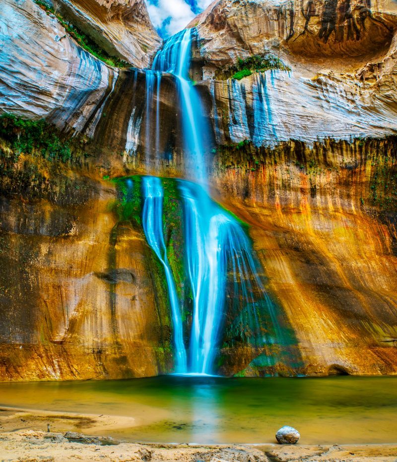
Some hikes feel like they are slowly turning down the desert heat, and Lower Calf Creek Falls does that with every step along its creek.
The first time I hiked it, the sound of water gradually got louder while canyon walls rose higher, and by the time the waterfall came into view, the whole canyon felt cooler.
This out and back trail is roughly six to seven miles with moderate elevation gain, following sandy and sometimes rocky paths beside the creek until it ends at a turquoise pool and a one hundred twenty six foot waterfall pouring over streaked sandstone.
The hike starts from the Calf Creek Recreation Area along Utah State Route 12 between Boulder and Escalante, signed near the day-use parking and campground at W Utah State Highway 12, Escalante, Utah 84726.
After a temporary closure during a 2024 project, the area has reopened with renewed attention on facilities and resource protection, which makes it especially important to stay on the main path and respect posted guidelines in 2026.
I usually budget extra time here, because it is almost impossible to leave quickly once you sit down on the sand and listen to the falls.
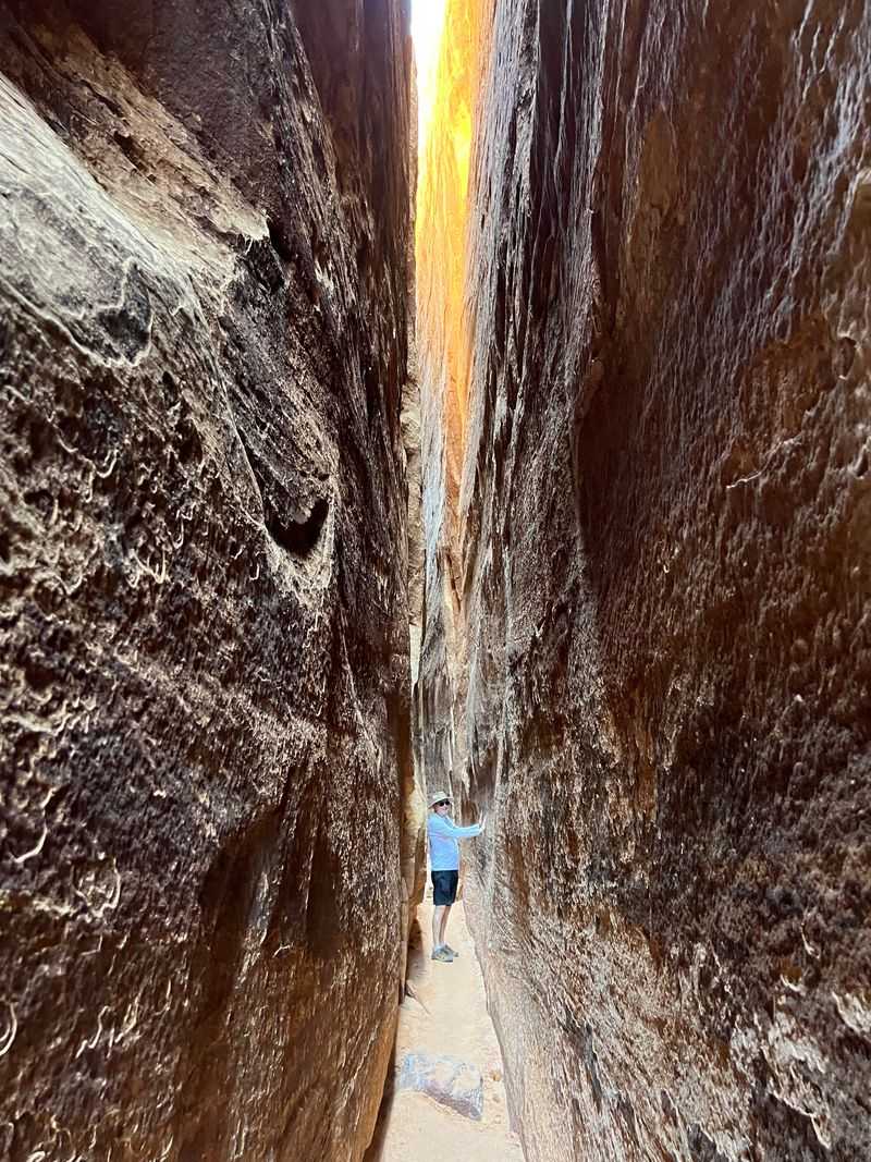
10. Kanarra Falls Trail: Kanarraville, Utah
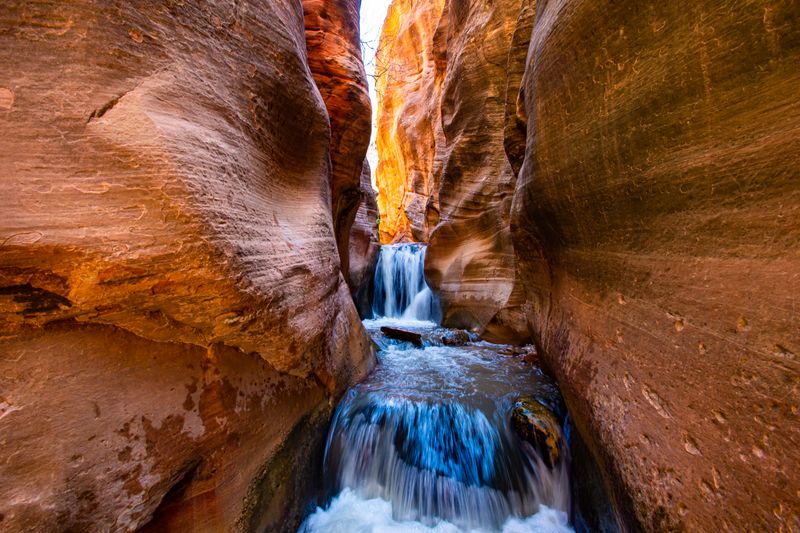
If you like your hikes with a bit of puzzle solving, Kanarra Falls is the trail that hands you ladders, narrow slots, and flowing water to figure out.
On my visit, I remember laughing as everyone hesitated at the first wooden ladder, politely debating who would be brave enough to go first while the creek swirled around our ankles.
The hike is a few miles round trip, depending on how far you explore, following Kanarra Creek into a sandstone slot canyon where small waterfalls, shallow pools, and sculpted walls keep the scenery changing every few minutes.
You begin from the Kanarra Falls Trailhead parking area at 345 East 100 North Street, Kanarraville, Utah 84742, where signed paths and a clear kiosk make it easy to start in the right direction.
The town strictly limits daily use with a paid permit system that, as of 2025, caps visitors at around one hundred eighty people per day, a policy very likely to continue in 2026, so buying tickets online before driving out has become essential.
Water shoes, trekking poles, and a sense of humor about wet socks go a long way toward making this canyon feel like one of the most playful hikes in the state.
11. Lake Blanche Trail: Big Cottonwood Canyon, near Salt Lake City, Utah
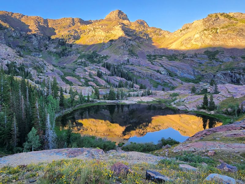
Lake Blanche is the hike that finally convinced me that suffering uphill can pay off in full panoramic currency.
The first time I reached the lakes, I dropped my pack next to the shore, stared up at Sundial Peak, and completely forgot how many times I had questioned my life choices on the way up.
This steep out-and-back trail runs roughly six to seven miles with significant elevation gain, climbing from the forested canyon floor to an alpine basin holding three lakes and big views back toward the Salt Lake Valley.
The route starts at the Mill B South Fork Trailhead, which shares a parking lot off East Big Cottonwood Canyon Road, Salt Lake City, Utah 84121, just below the well-known S curve of the canyon.
Because the trail is popular and parking limited, I like to arrive early and treat the shaded lower section as a gentle warmup before the real climb begins.
Standing by the water with Sundial Peak reflected on a calm morning is the kind of payoff that makes you start planning a repeat visit long before your legs fully recover.
12. Mount Timpanogos via Timpooneke Trail: American Fork Canyon, Utah
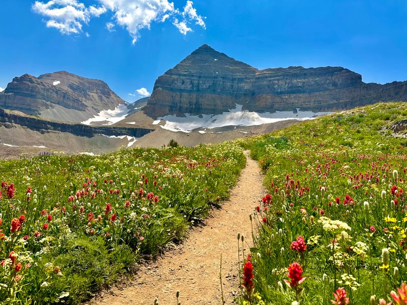
Some summits feel like graduation ceremonies for your hiking season, and Mount Timpanogos via the Timpooneke Trail absolutely falls into that category.
On my first big push here, I remember starting before dawn, watching headlamps snake up the switchbacks, and listening to everyone quietly wonder whether the sunrise or the eventual summit would be the bigger reward.
The Timpooneke route is a long day, often fourteen to fifteen miles round trip with thousands of feet of elevation gain, climbing from forest through wildflower meadows and rocky slopes to a broad summit ridge with far-reaching views and a good chance of spotting mountain goats along the way.
You access the trail from the Timpooneke Trailhead at Timpooneke Campground along the Alpine Loop section of State Route 92, about ten miles up the canyon from the mouth of American Fork Canyon near Highland, Utah 84003.
A timed entry system for the trailhead is rolling out through Recreation.gov to manage crowding, so anyone dreaming about a 2026 summit should get comfortable with booking windows and date reminders well before summer.
By the time I shuffle back to the car after a Timpanogos day, dusty, hungry, and very content, it always feels like the kind of hike that makes every shorter outing afterward seem pleasantly easy.