Buckle Up For A 103-Mile Colorado Road Trip Packed With Hidden-Gem Views
The best road trips do not always shout for attention, sometimes they simply unfold mile by mile until you realize you have been completely hooked.
This 103-mile drive through Colorado is that kind of route, the one that trades roadside noise for high plains, rugged canyon walls, shifting light, and mountain passes that make the detour feel like the whole point.
It begins near a busy stretch of southern travel, then quickly reminds you why slower roads are often the smarter choice. Every curve brings a new texture: open horizons, stone-cut drama, quiet valleys, and that satisfying feeling of finding a route most people hurry past.
This is not a drive built around gimmicks. It is built around scenery that earns your attention honestly.
In Colorado’s southern landscape, the reward is simple: leave the interstate behind, follow the road, and let the view do the talking.
Where The Road Begins: Pueblo As Your Launch Pad

Not every great road trip starts somewhere glamorous, and Pueblo, Colorado is perfectly fine with that. The official information hub is located at 301 N.
Union Ave., Pueblo, CO 81003, which makes it a logical and practical first stop before you head south toward the mountains.
Pueblo sits at the edge of the high plains, which means the landscape shift you experience as you leave town feels almost theatrical. One minute you are looking at a flat horizon, and the next the land starts folding upward like someone is slowly raising a curtain.
Quick Tip: Before you leave town, fill your gas tank and grab snacks. The byway passes through stretches of Colorado where convenience stores are not exactly clustered together.
Pueblo itself has a compact downtown worth a short Main Street stroll if you arrive early. The city functions as a real working town, not a tourist facade, which gives your departure a grounded, unhurried feeling.
Starting here sets the tone for a drive that values the actual journey over the social media version of it.
Best For: Weekend planners, couples, and families looking for a confident, low-effort launch point with genuine regional character.
The Route Itself: 103 Miles That Earn Every Inch

Covering 103 miles through southern Colorado, the Frontier Pathways Scenic and Historic Byway is a designated National Scenic Byway, which means it has met federal standards for natural, cultural, and recreational significance. That is not a marketing phrase.
It is a quiet official acknowledgment that this road is genuinely worth your time.
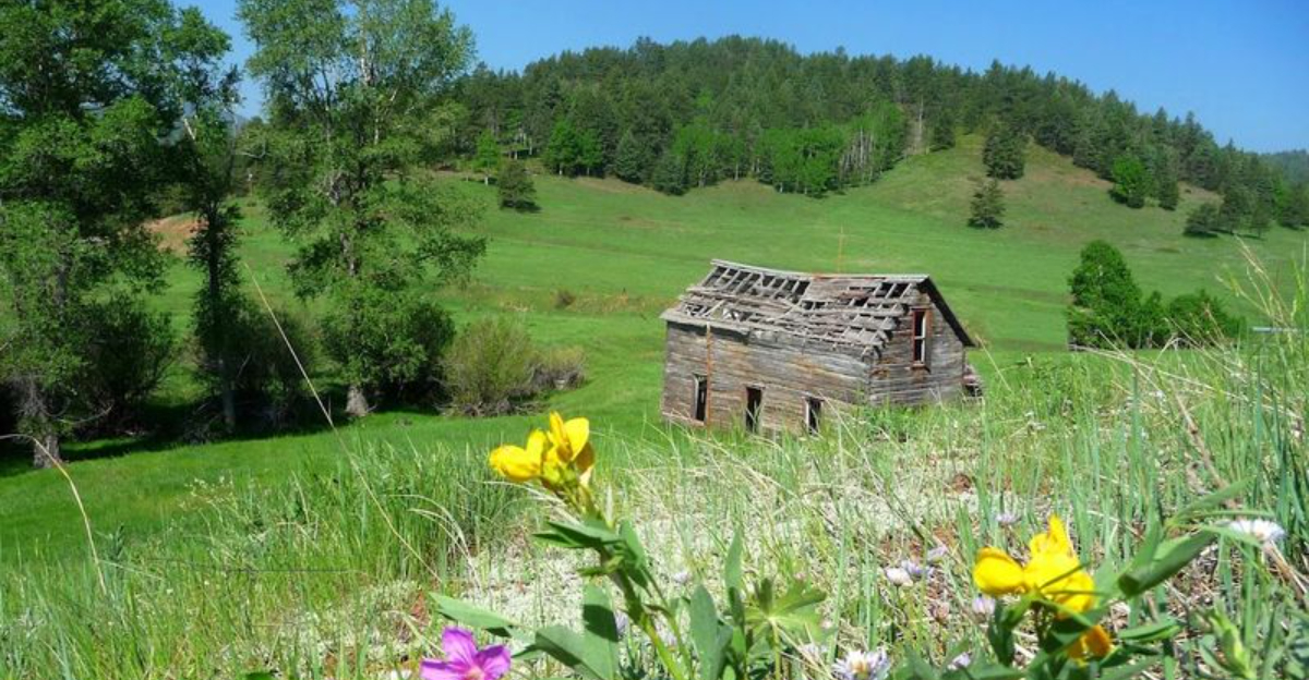
The route travels through the Wet Mountains, climbs toward the Sangre de Cristo range, and passes through terrain that shifts dramatically as your elevation changes. Forests replace flatlands, canyon walls appear without much warning, and the whole effect is one of continuous geographic surprise.
Why It Matters: Unlike many scenic routes that peak early and then coast, this byway maintains visual interest across its full length. The landscape does not repeat itself.
The road is open 24 hours, which technically makes it a candidate for a sunrise or sunset drive if you are the type to plan around golden light. Visitors have consistently rated the experience highly, with nearly perfect scores across multiple visits in different seasons.
Fall, in particular, draws travelers specifically for the aspen tree displays that line portions of the route.
Insider Tip: Late September is widely considered the sweet spot for fall foliage along this byway, especially if aspens are your primary target.
Aspen Season: When The Trees Steal The Whole Show

Visitors who have driven the Frontier Pathways Scenic and Historic Byway in late September describe the aspen displays as genuinely stunning, and that word gets used so often in travel writing that it has nearly lost its meaning. Here, it earns its place back.
Aspen trees turn a specific shade of gold that does not photograph the way it looks in person. You can try, and you probably should, but the actual experience of standing inside a grove of quaking aspens while the leaves rattle in a mountain breeze is something a screen cannot replicate.
Best Strategy: Aim for the last weekend of September if your schedule allows. That window consistently delivers peak color along the byway based on visitor accounts and regional foliage patterns in the Wet Mountains.
The route passes through stretches of forest where the aspen groves are dense enough to create a tunnel effect on the road. Sunlight coming through those leaves at midday produces a quality of light that stops conversations mid-sentence.
Planning Advice: Fall weekends on this byway attract more traffic than other seasons. An early morning start, before 9 a.m., gives you cleaner views at pull-off points and a more private experience overall.
Pull-Off Points: The Honest Truth About Stopping

Here is something worth knowing before you go: pull-off signage along the Frontier Pathways Scenic and Historic Byway is an area where the route has room to improve. Visitors have noted that more clearly marked stopping points would make the drive even more accessible, particularly for first-timers who are not sure where it is safe or worthwhile to pause.
That honest piece of feedback does not diminish the drive. It just means you should go in prepared rather than expecting a highly curated, sign-every-quarter-mile experience.
Keep your eyes open, drive at a pace that lets you react when something catches your attention, and do not feel rushed.
Common Mistakes to Avoid: Do not drive this route at highway speed with the goal of finishing quickly. The byway rewards a relaxed pace.
Pulling over on a wide shoulder to take in a canyon view is part of the experience, not an interruption of it.
If you are traveling with kids, frame the pull-off search as a game rather than a logistical frustration. The landscape itself provides enough variety that spotting a good stopping point becomes its own small adventure.
Pro Tip: A paper map or downloaded offline route can help you anticipate upcoming viewpoints when cell service gets thin in the mountain sections.
Mid-Route Reality Check: What Keeps This Drive Honest

Around the halfway point of any long scenic drive, there is a moment where the initial excitement levels out and you start paying attention to different things. The gas gauge.
The snack situation. Whether the playlist is still working.
This is actually when the Frontier Pathways byway starts showing its quieter strengths.
The route passes through areas of Colorado that feel genuinely remote without being inaccessible. You are not deep in the backcountry, but you are far enough from the interstate that the ambient noise of modern life drops considerably.
That quality is harder to find than it sounds in 2024.
Who This Is For: Drivers who want scenery without theme-park infrastructure. People who find value in a long quiet stretch of mountain road with no agenda attached to it.
Who This Is Not For: Anyone expecting dense amenities, frequent fuel stops, or a heavily guided experience. This byway asks you to bring your own curiosity and a reasonably full tank.
The middle section of the route is where the Wet Mountains earn their name in feel if not always in weather. The terrain is dense, layered, and geographically serious in a way that reminds you Colorado is not performing for you.
It simply exists, and you are passing through it, which is exactly the right dynamic for a road like this.
Making It A Full Day: Simple Planning That Actually Works

The Frontier Pathways Scenic and Historic Byway is open every day, all day, which gives it a flexibility that most attractions simply cannot match. You can start at dawn, finish by early afternoon, and still have time to grab a meal back in Pueblo before the day is over.
That kind of clean logistics is genuinely underrated.
For families, the drive itself functions as the activity. There is no admission fee, no reservation required, and no schedule to keep.
You move at whatever pace works for the group, stop when something looks interesting, and keep going when it does not.
Quick Verdict: For couples, the byway offers 103 miles of shared attention with minimal distraction. For solo drivers, it is a rare stretch of American road that feels like it was designed for exactly this kind of quiet, purposeful travel.
A post-errand reward framing works well here too. If you are already in the Pueblo area for other reasons, tacking on even the first 30 or 40 miles of the byway turns an ordinary Saturday into something worth mentioning later.
Best For: Families with flexible schedules, couples planning a day trip from Pueblo or the surrounding region, and solo travelers who prefer their scenery without a crowd managing it for them.
The Lasting Impression: Why This Route Stays With You

There is a specific kind of road trip memory that does not come from a famous landmark or a well-photographed destination. It comes from a stretch of road that asked nothing of you except attention, and delivered something you were not fully expecting.
The Frontier Pathways Scenic and Historic Byway produces that kind of memory reliably.
Visitors who have driven it return with consistent language: beautiful, scenic, worth it. That consistency across different seasons and different types of travelers says something meaningful about the route itself.
It is not dependent on perfect conditions to deliver.
Quick Verdict: If you are within driving distance of Pueblo, Colorado and you have a free Saturday, this byway is the clearest possible answer to the question of what to do with it. The route starts at 301 N.
Union Ave. and unfolds from there in a direction that reliably justifies the detour.
The best road trips do not demand that you remember every mile. They just leave you with the quiet certainty that the drive was worth more than the time it took.
This one does exactly that, and it does it across 103 miles of Colorado terrain that has no interest in being anything other than exactly what it is.
Planning Advice: Save the website at frontierpathways.com before you go. It is a quick stop off your route planning that pays off on the road.