10 Colorado Drives That Are Even Better With The Windows Down
Some drives feel less like transportation and more like proof that a good road can change your mood. In Colorado, a scenic route can turn a simple afternoon into the kind of memory you talk about long after the engine cools.
One minute the road slips between canyon walls, the next it opens into wide country, then climbs toward peaks that seem to pull the sky closer. That is the magic of riding with the windows down: every curve feels louder, fresher, more alive.
These are not just lines on a map or quick shortcuts between destinations. They are slow-burn adventures built for playlists, spontaneous stops, roadside overlooks, and that happy silence that hits when everyone in the car is staring out the window.
Give yourself time, skip the rush, and let Colorado’s scenery do what it does best: turn an ordinary drive into the whole reason you left home.
1. Flat Tops Trail Scenic Byway

Starting at the Meeker Chamber of Commerce on 710 Market Street in Meeker, Colorado, this byway feels like the kind of drive that rewards the unhurried traveler. The road stretches roughly 82 miles before finishing at the Yampa Town Offices on 101 Main Street in Yampa, and nearly every mile earns its place.
The Flat Tops Wilderness sits at one of the highest plateau elevations in the country, and driving through it with the windows down means breathing in cool, pine-scented air that genuinely clears your head.
Aspen groves line the road in thick golden waves during fall, making the whole corridor look like a painting someone forgot to finish.
Elk sightings along this stretch are common enough to keep passengers leaning toward the window.
My honest take: this is a byway that earns its reputation without trying too hard. The pace feels unhurried, the scenery is uninterrupted, and the towns on either end are small enough to feel like genuine discoveries.
Pack a cooler, plan for a full day, and resist the urge to rush. The Flat Tops does not reward rushing.
2. Unaweep-Tabeguache Scenic and Historic Byway

There is something almost geological about the Unaweep-Tabeguache Byway, as if the road was carved out by forces that had no interest in convenience.
Beginning at the Unaweep Tabeguache Interpretive Visitor Center on 230 West Main Street in Naturita, Colorado, the drive ends near the Gateway Auto Museum area at 43224 Highway 141 in Gateway, a destination that somehow makes perfect sense once you arrive.
Unaweep Canyon is the geological showstopper here. It is one of the few canyons in North America drained by two rivers flowing in opposite directions, which sounds like a riddle until you see it and feel oddly proud of the planet.
The canyon walls rise steep and red, and with the windows down you catch warm, dry air mixing with the faint mineral smell of ancient rock.
I would call this drive underrated, but that feels too mild. It is genuinely spectacular in a way that sneaks up on you.
The Gateway end of the route rewards you with a surprise: a world-class auto museum sitting in the middle of canyon country. Plan an early start from Naturita, stop at the interpretive center, and give yourself permission to linger at every pullout.
3. Silver Thread Scenic Byway

The Silver Thread Scenic Byway begins at the South Fork Visitor Center on 28 Silverthread Lane in South Fork, Colorado, and finishes at the Lake City/Hinsdale County Visitor Center on 800 Gunnison Avenue in Lake City.
Between those two stops, the drive follows the Rio Grande and winds through some of the most quietly beautiful canyon terrain in the entire state.
Silver Thread gets its name from the ribbon-like quality of the river as it threads through tight canyon walls, and that visual holds up in person. The road is narrow in places, which actually works in your favor because it forces you to slow down and pay attention.
Windows down, you hear the river before you see it on most stretches, and that sound alone is worth the detour.
Lake City, the finishing point, is a Victorian-era mountain town with a population small enough that everyone at the diner knows you are new. I find that charming rather than unsettling.
The whole drive clocks in around 75 miles, making it a manageable half-day trip that feels twice as long in the best possible way. Go mid-morning when the canyon light is still soft and the road is yours.
4. Highway of Legends Scenic Byway

Few byways in Colorado carry as much storytelling weight as the Highway of Legends, and it earns that name early.
Starting at the Trinidad Welcome Center on 309 Nevada Avenue in Trinidad, Colorado, the route finishes at La Veta Town Hall on 209 South Main Street in La Veta, covering terrain that mixes volcanic geology, Native American history, and old coal mining culture into one unforgettable corridor.
The Spanish Peaks are the visual anchors of this drive, twin volcanic mountains that rise dramatically from the surrounding grasslands. They were used as navigation landmarks by travelers for centuries, and you quickly understand why the moment they appear on the horizon.
With the windows down, the air transitions from the warm, dry flatlands near Trinidad to the cooler, pine-scented elevations around Cuchara Pass.
Trinidad itself deserves more credit as a starting point. It is a small city with genuine architectural character and a surprisingly rich arts scene.
La Veta, the finishing town, has the kind of main street that makes you want to park and walk without a plan. The full route runs about 82 miles, and I recommend it strongly for a fall Saturday when the aspens are cooperating and the light is doing something unfair.
5. Frontier Pathways Scenic Byway

Starting at the Pueblo Welcome Center on 310 Central Main Street in Pueblo, Colorado, the Frontier Pathways Scenic Byway is the kind of drive that quietly builds its case mile by mile. By the time you reach the Custer County Visitor Center on 107 North 3rd Street in Westcliffe, you have moved through three distinct landscapes without ever feeling rushed.
The Wet Mountains form the backbone of this route, and they deliver a softer, more gradual drama than the jagged peaks you find elsewhere in Colorado. Rolling meadows give way to ponderosa pine forests, and the Sangre de Cristo range sits in the distance like a painted backdrop that gets sharper as you climb.
Windows down, the air cools noticeably once you hit elevation, and there is a particular freshness to mountain air in this part of the state that is hard to describe without sounding like a tourism brochure.
Westcliffe, the endpoint, is a ranching town with one of the best dark sky designations in the country. If you time it right and stay for sunset, the drive back to Pueblo under a fully lit sky feels like a bonus feature nobody warned you about.
Budget a full day and bring snacks from Pueblo before you leave.
6. Pawnee Pioneer Trails Scenic Byway

Not every great Colorado drive climbs a mountain. The Pawnee Pioneer Trails Scenic Byway starts at the Fort Morgan Museum on 414 Main Street in Fort Morgan, Colorado, and stretches northeast to the Colorado Welcome Center at Julesburg on 20934 County Road 28.
This is plains driving at its most elemental, and it deserves more respect than it typically gets.
The Pawnee National Grassland is the centerpiece, a vast sweep of shortgrass prairie that looks almost unchanged from what early homesteaders and Native peoples would have seen. The sky here is genuinely enormous, the kind of open horizon that makes you feel both small and strangely calm at the same time.
With the windows down, wind rushes through in waves, and the smell of dry grass and earth is as distinctive as any alpine meadow.
Pawnee Buttes, two sandstone formations rising from the flat grassland, are the surprise landmarks that make passengers sit up straight. I was not expecting to be moved by a plains drive, and then I was.
Fort Morgan, the starting point, is a straightforward agricultural town with good coffee options and a museum worth a quick stop. The full route runs around 125 miles, making it a comfortable day trip from Denver or Fort Collins.
7. South Platte River Trail Scenic Byway

The South Platte River Trail Scenic Byway is a bit of an outlier on this list because it starts and ends at the same place: the Colorado Welcome Center at Julesburg on 20934 County Road 28 in Julesburg, Colorado.
That loop structure makes it a natural choice for a half-day excursion when you want scenery without the logistics of a point-to-point shuttle.
The drive follows the South Platte River through northeastern Colorado, a region that does not get nearly enough travel attention. The landscape here is wide and agricultural, with cottonwood-lined riverbanks breaking up the flat horizon in a way that feels genuinely peaceful rather than monotonous.
Windows down, you catch the river smell mixed with the earthy warmth of farm fields, which sounds unglamorous but is actually quite grounding.
Julesburg itself has an interesting backstory as the only Colorado town that has existed in four different locations, all within a few miles of each other. That kind of stubborn persistence earns my admiration.
The Welcome Center staff are genuinely helpful and can point you toward the best stopping points along the route. Start early, bring water, and give yourself permission to pull over whenever the cottonwoods look good in the morning light.
8. Cache la Poudre-North Park Scenic Byway

Named after a river with a story behind it, the Cache la Poudre-North Park Scenic Byway starts at the Visit Fort Collins Welcome Center on 7 Old Town Square, Suite 100, in Fort Collins, Colorado, and finishes at Visit North Park on 404 4th Street in Walden.
The 101-mile route is one of the most varied drives in the state, moving from a lively college city to a remote mountain valley in a single afternoon.
The Cache la Poudre River, Colorado’s only designated Wild and Scenic River, runs alongside much of the route through Poudre Canyon, and driving with the windows down here is almost an audio experience.
You hear the river crashing over boulders before the canyon even narrows, and by the time the walls close in around you, the sound fills the car completely.
It is the kind of natural soundtrack that makes whatever was stressing you out feel very far away.
North Park, the broad valley at the journey’s end near Walden, is moose country. Actual, large, unhurried moose.
I spotted two on my last run through, and both seemed entirely unbothered by the audience. Plan this drive for a clear weekday morning if possible, and stop for coffee in Fort Collins before you leave civilization behind.
9. Grand Mesa Scenic Byway

Grand Mesa is the largest flat-top mountain in the world, and the byway that crosses it makes sure you know that fact by the time you reach the top.
The route starts at the Grand Mesa Visitor Center on 20090 Baron Lake Drive in Cedaredge, Colorado, and ends at the GMUG Forest Supervisor’s Office on 2250 South Main Street in Delta, covering about 55 miles of terrain that swings from orchard country to alpine plateau in a way that feels almost theatrical.
Cedaredge sits in a fruit-growing belt where peach and apple orchards line the lower slopes, and driving out of town in late summer means the air through your windows carries a sweetness that is almost embarrassingly pleasant.
Once you climb onto the Mesa proper, the landscape shifts completely: dense spruce forests, more than 300 lakes, and a cool, clean elevation that makes you want to stop the car and just stand outside for a while.
Delta, the finishing point, is a Western Slope town with a relaxed pace and good local dining options. The drive is manageable in about two hours without stops, but I strongly advise building in extra time for the lake overlooks near the top.
Fall foliage on the Grand Mesa is legitimately one of Colorado’s best-kept seasonal secrets.
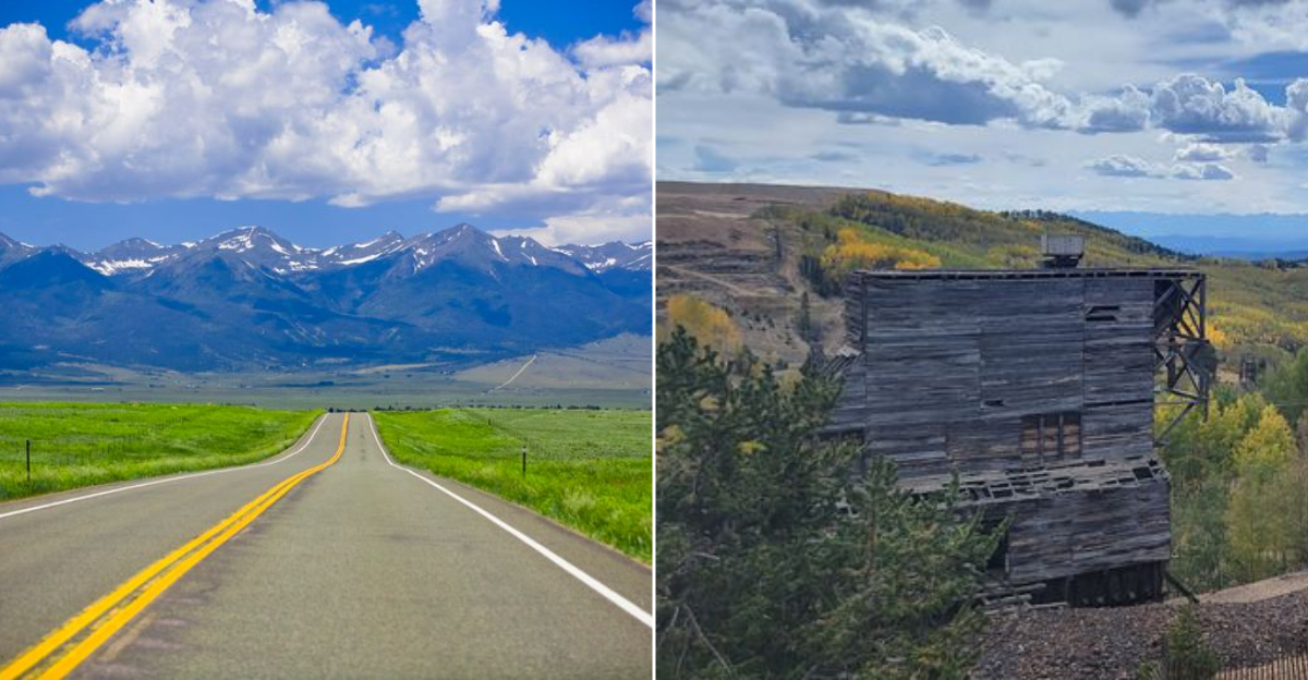
10. Gold Belt Tour Scenic Byway

Gold was the original reason people came to this part of Colorado, and the Gold Belt Tour Scenic Byway does a fine job of honoring that history without turning the whole experience into a museum exhibit.
The drive starts at Florence City Hall on 600 West 3rd Street in Florence, Colorado, and finishes near the Cripple Creek Heritage Center area in Cripple Creek, climbing from river valley antique territory up into one of the most storied mining districts in American history.
Florence is a surprising starting point in the best way. The town has developed a reputation as an antiques destination, and Main Street rewards an early morning browse before you head uphill.
The road climbs steadily through Royal Gorge country and high desert terrain, and with the windows down you move through layers of temperature and scent as the elevation changes beneath you.
Cripple Creek sits at nearly 10,000 feet and still carries the faded grandeur of a town that once out-produced nearly every other gold camp in North America. The views from the upper sections of this drive are the kind that make passengers go quiet for a few minutes, which I consider the highest compliment any road can receive.
Budget a full day and start in Florence by nine.