Michigan Scenic Drives Made For Gray Skies, Fresh Greenery, And Moody April Views
April in Michigan is essentially a giant mood ring that can’t quite decide if it’s “atmospheric gray” or “hopeful green,” and honestly, I’m here for the drama. I’ve learned that this is the best time to pack a thermos, ignore the GPS, and just drive until the sky starts flirting with the horizon.
There is a specific kind of magic in the way a stand of sugar maples smells like a literal bakery after a spring rain, or how a lonely lighthouse seems to hum a low-frequency tune when the crosswinds hit just right.
The roads are blissfully empty, giving you permission to crawl along the shoreline and watch the “bruise-colored” lake water churn against the dunes.
Michigan scenic drives in the spring offer a peaceful way to explore coastal lighthouses and budding forests without the summer crowds. Everything is shifting faster than your weekend plans, but that’s the beauty of a moody April loop.
1. Tunnel Of Trees, M-119 Between Harbor Springs And Cross Village
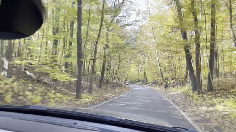
Quiet light pools along M-119 as hardwood branches knit a lacy canopy above the pavement. The road is narrow, curving past blufftop cottages and glimpses of slate-colored Lake Michigan.
April mutes the palette, yet moss pops electric on stone walls. Sandhill cranes bugle somewhere inland, their primeval rattles echoing through the damp trunks.
This stretch is arguably the most famous drive in the state. But in the spring, it feels like a private secret.
The usual summer congestion is nowhere to be found. That allows you to actually appreciate the tight curves and the way the forest floor is beginning to wake up with leeks and spring beauties.
History lingers in the route between Harbor Springs and Cross Village, once a shoreline footpath for Anishinaabe travelers and later a rustic resort corridor for the wealthy in the late 19th century. Traffic stays slow, and pull-offs are scarce.
So you will want to plan your photo stops at Devil’s Elbow, where the road twists sharply over a ravine, or the iconic Good Hart General Store.
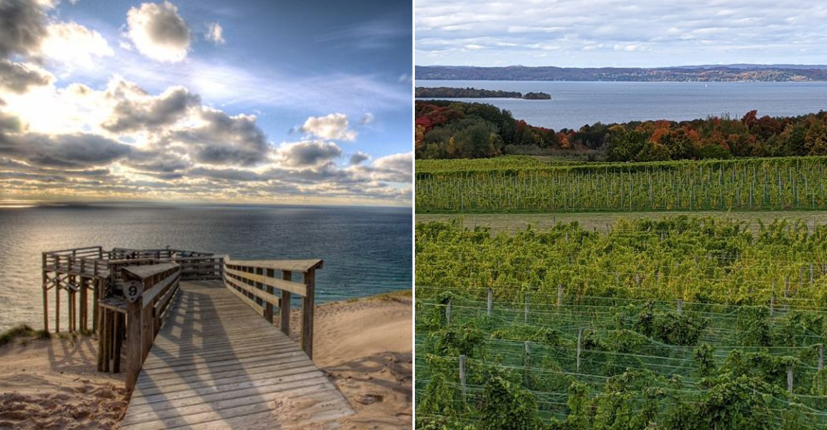
2. M-22 Through The Leelanau Peninsula
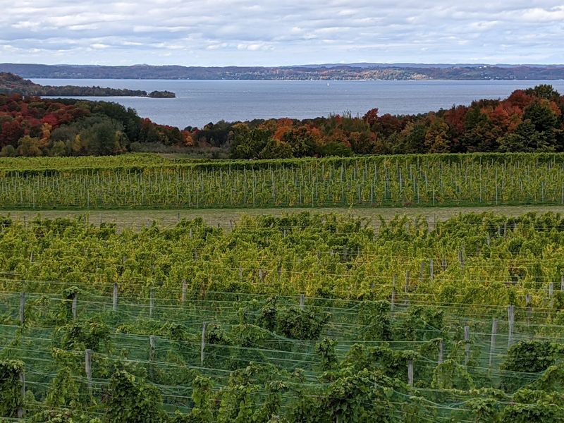
Whitecaps stipple the bay while orchards show tight green buds along M-22’s curves. Small towns appear like commas, Leelanau, Glen Arbor, Leland, then vanish behind cedar windbreaks and old barns.
April clouds hang low, sharpening the line where the towering dunes meet the biting, cold water. There is a specific nostalgia here.
It is a feeling of the Old Michigan that persists despite the modern wineries and chic boutiques.
In April, the peninsula feels like a land of potential. Millions of cherry blossoms are waiting for that one perfect warm afternoon to explode into white.
Prohibition-era fish shanties in Fishtown still work, though mostly for Smoked Whitefish and local stories these days. I like to park near the harbor in Leland and grab a steaming cup of coffee.
Then I follow the boardwalk to read the lake’s mood before committing to the next leg of the journey.
The shoulders are notoriously narrow on this highway, so it is wise to utilize the village parking lots and designated roadside overlooks like the Whaleback Natural Area.
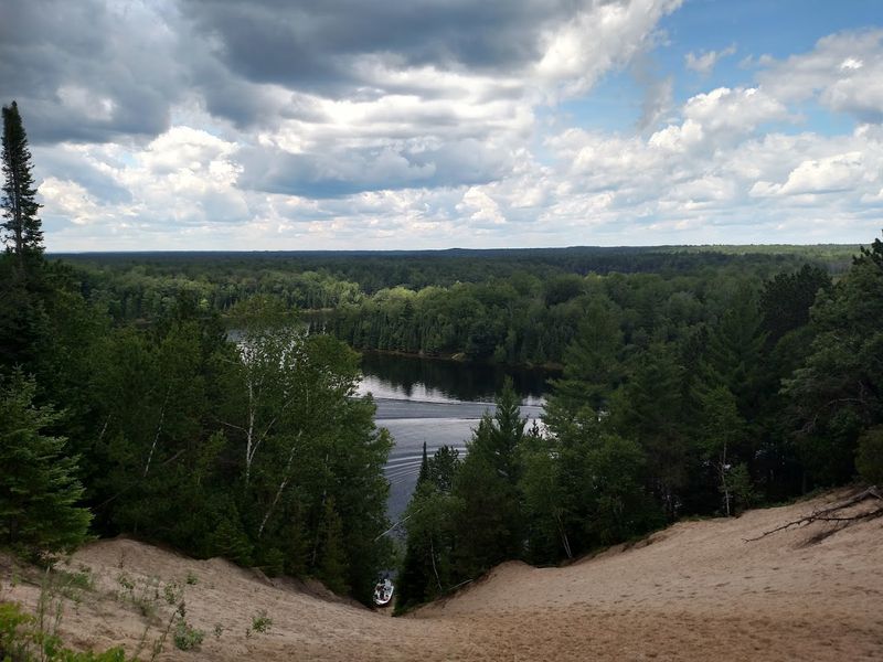
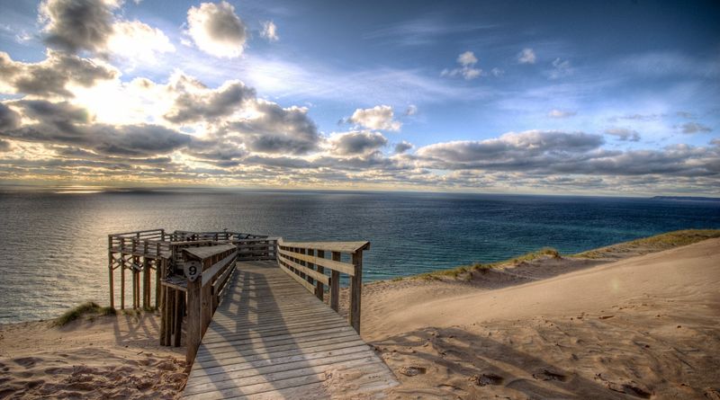
3. Pierce Stocking Scenic Drive, Empire
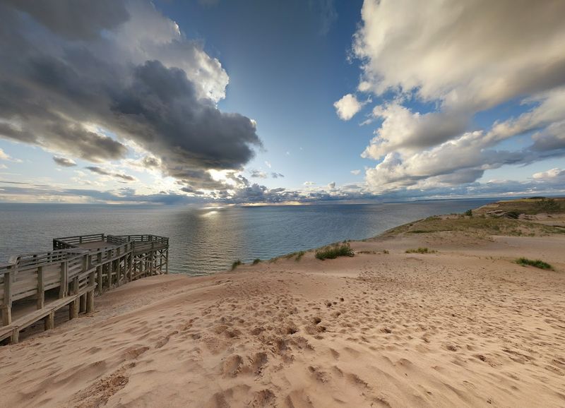
Dunes rise like sleeping animals beside this short, curated loop through the Sleeping Bear Dunes National Lakeshore. Boardwalks and overlooks fan out to summon the lake’s horizon.
It often looks like a solid silver bar under a heavy April cloud. Even in the chill, the wind often carries a faint, sugary note from spring sap boiling in nearby farm towns like Empire.
This drive is a masterclass in glacial geography. It shows off the massive scale of the perched dunes that sit high above the water level.
Built by a dedicated forester, the route honors Pierce Stocking’s love of accessible vistas and careful, artistic curves. Because the traffic gates are seasonal, you must confirm the official opening dates before you set out.
It is always better to go early in the morning to avoid the light influx of weekend visitors.
The sand shifts constantly with the spring gales, often creating soft shoulders near the Dune Overlook. So sneakers definitely beat flip-flops when the stairs are damp or covered in grit.
You must pause at Overlook No. 9 for the heart-stopping 450-foot drop to Lake Michigan. It is a view that makes you feel both tiny and incredibly alive.
4. River Road National Scenic Byway, Oscoda area
The Au Sable River runs parallel to this route, tea-colored and muscular from the spring thaw, as the byway climbs high bluffs and dips toward quiet boat landings. April opens up the forest understory.
That means you can often glimpse bald eagles or ospreys riding the thermals above the Lumberman’s Monument.
The air is heavy and sweet with the smell of pine resin. The dam backwaters look like tarnished mirrors under the flat, morning light.
Logging history crowds these hills, marked by interpretive stops and beautiful CCC-era stonework at the various overlooks. The route is straightforward, yet the curves tighten significantly near the riverbanks.
You should expect your cell service to fade in the deeper pockets of the valley.
Bring plenty of layers, because the river wind always bites a little harder than the thermometer implies. The dirt trails can be slick with the remaining thaw.
Pack a picnic to enjoy at Iargo Springs, where more than 200 wooden stairs lead you down to the mysterious bubbling trickles of water coming from the earth.
5. US 23 Heritage Route Along The Sunrise Coast
Morning comes sideways on Lake Huron, pale light sliding across breakwalls and brittle beach grass. US 23 tracks the curve from Standish through Tawas and Oscoda toward Alpena.
You are never more than a short distance from the blue. April on the Sunrise Coast means quiet motels, closed ice cream windows, and gulls arguing over one soggy fry in a parking lot that will be packed in three months.
It is the perfect time for a contemplative road trip. The only traffic you face may be a slow-moving freighter on the horizon.
Shipwreck lore flavors the small museums along this stretch. Beacons like the Sturgeon Point Lighthouse anchor the horizon with their stoic, white-painted presence.
I usually plan my stops at the various roadside parks for leg breaks and lake-watching. The highway shoulders can be narrow and the traffic gets brisk near the larger town centers.
Keep a little cash on hand for state park day passes, and keep a sharp eye on the weather. The open stretches of Huron can produce a sudden gale that will rock even the sturdiest SUV.
6. Brockway Mountain Drive, Copper Harbor
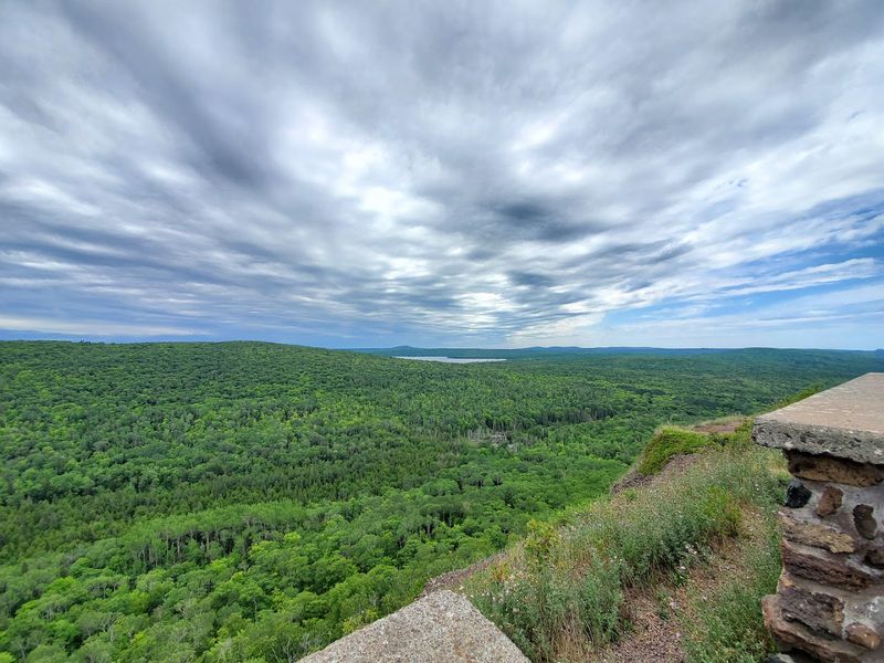
Lake Superior looks hammered flat from the high ridge of Brockway Mountain, a wide sheet of water catching the dim, metallic April light. The road climbs steeply from Copper Harbor through basalt knobs.
Then it follows the high spine of the mountain past stunted spruce and hardy lichen. On the quietest days, you can actually hear the ice groan in the shaded ditches where winter lingers well into May.
This is the highest drive between the Rockies and the Alleghenies. The thin, cold air feels like a tonic for a weary spirit.
Built in the 1930s as a public works project, the drive has become a sacred tradition for spring birders who come to watch the massive hawk and eagle migrations. The curves are incredibly tight and the pull-offs are small.
Your visibility can drop to zero in seconds when a thick fog rolls in from the Big Lake.
Bring a heavy warm layer, because it is always ten degrees colder up here. Respect the edge of the road, as there are long, unfenced drops.
Stop at the summit kiosk to orient yourself, then wander the rock paths to see what tiny alpine flora is starting to wake up.
7. M-35 Along The Upper Peninsula Hidden Coast
Between Escanaba and Menominee, M-35 traces the scalloped edge of Green Bay, passing limestone quarries, cedar swamps, and sudden, hidden beaches. April paints the shallows a deep tea-green.
You will see gulls rafting near the floating ice remnants like tiny, living sails. The vibe here is workaday coastal.
Fishing boats and factory stacks share the view in a way that feels honest and unpretentious.
It is a hidden coast because many travelers bypass it for the more dramatic Superior shore. Their loss is your gain.
Summer colonies peek out from clusters of cottages near the Cedar River. If you are lucky, a roadside pasty stand might be open for its first weekend of the year.
I often pull over for some sandstone hunting at Fox Park, though you have to be cautious with the cold April chop hitting the rocks.
The route is mostly straightforward, but be aware that the shoulders narrow significantly beside the rock faces. Large timber trucks often use this corridor to move logs.
8. Traverse City To Sleeping Bear Dunes Via M-72 And M-22
Leaving the heart of cherry country, the two-lane climb on M-72 frames Grand Traverse Bay in soft, slate-colored ripples. Pine plantations give way to the rolling sand hills.
The roadside often smells faintly of ferment near the local wineries as they prepare their casks. In April, the tourist traffic is blissfully light.
But you will still need to share the road with farmers moving their equipment deliberately between the budding orchards.
This route ties directly into the National Lakeshore’s various overlooks and trailheads. Each one offers a quick study in the lake’s ever-changing mood.
The DeYoung Natural Area and the pull-out at Inspiration Point provide the perfect tempo-reset. They offer views that invite a much longer pause than you planned.
The shoulders are a bit of a mixed bag, some gravel, some pavement, so it is best to stick to the designated lots and heed the posted signs. Keep in mind that heavy spring rains can occasionally flood the lower parking areas near the Platte River.
9. Harbor Springs To Good Hart On Lake Shore Drive
Lake Shore Drive slips even closer to the bluffs than the main M-119 route, with mailbox clusters and thick cedar hedges hugging the very edge of the lane. The shoreline below alternates between fans of smooth, wave-washed cobble and tiny pockets of sand.
Each makes a different sound under the gray April chop. In the spring, the porch of the Good Hart General Store often holds the remains of winter salt stains.
A chalkboard excitedly announces the week’s pie schedule.
A 19th-century schoolhouse still stands along this way, its white clapboards as straight as a metronome. It whispers about the rhythm of long, isolated winters.
I sometimes pull into a local driveway just to catch a photograph of the light hitting the water. But I always make sure to return to the road respectfully.
There are very few public turnouts on this specific stretch, and most driveways are strictly private. So it is best to save your lingering for the actual village of Good Hart.
10. Rogers City To Alpena Along Lake Huron
Limestone is the defining characteristic of this run, from the massive quarry views near Rogers City to the breakwalls stacked like pale, sun-bleached bones. The lake stays incredibly close to the pavement here.
One minute it is the color of cold slate. The next it is a bright peppermint green as the April light shifts through the low clouds.
Gulls often sit in the air above the piers, staying so still they look like part of the architecture. This is a rugged, industrial beauty that most people miss.
Freighters and karst topography coexist in this landscape, with mysterious sinkholes hidden inland. The Great Lakes Maritime Heritage Center in Alpena anchors the region’s history.
Heritage Route signs will keep you on the right course. I always recommend the side trips to the lighthouses at Forty Mile Point and Old Presque Isle.
The shoulders vary in quality, but roadside parks are frequent enough that you are never far from a place to stop. The public bathrooms usually open early in the spring season.