11 Most Breathtaking Hiking Trails In Michigan To Explore In 2026
I’ve spent enough time on the trail to know that a “good” hike isn’t just about the mileage, but about how much of the world you actually see when you finally stop looking at your watch.
In Michigan, the landscape performs. Walking these paths, you’re tracing centuries of mineral-stained cliffs and forests tuned to a very specific, prehistoric frequency.
There is a humbling, almost medicinal quality to a freshwater horizon that stretches so far it recalibrates your entire sense of scale. And usually, I’m looking for that “off the clock” island energy where the only schedule is the sun.
Standing atop 200-foot sandstone cliffs where the turquoise water of Michigan’s Lake Superior mimics the Caribbean and the ancient forest air resets your soul is something you just might need in 2026.
To ensure you don’t get humbled by the unpredictable Great Lakes weather, these eleven trail-tested insights are your essential gear check.
1. Chapel Loop (Pictured Rocks National Lakeshore, Munising)
The sound of the Big Lake is a constant companion here, as wave noise bounces off mineral-painted cliffs while gulls trace the invisible currents of the wind.
The Chapel Loop is the crown jewel of the Pictured Rocks National Lakeshore, a 10-mile trek that strings together the white sands of Chapel Beach, the gravity-defying arch of Chapel Rock, and grandstand overlooks of spray-polished sandstone.
On calm mornings, the water flashes a Caribbean turquoise, but it transforms into a formidable steel-blue the moment the lake decides to flex its muscles.
Exposed roots and deep sand keep your steps honest, and the interior forest sections smell like a freshly steeped pot of cedar tea.
The shoreline’s incredible palette isn’t an artist’s whim, it’s a geological slow-burn caused by iron, copper, and manganese leaching through the stone and staining the face of the cliffs.
You will likely pass several social paths branching off toward the cliff edges, but it is wise to keep a respectful distance.
The sandstone is notoriously crumbly, and the drop-offs are absolute.
Most veterans recommend a counterclockwise flow to save the dramatic cliff-side views for the second half of the day, passing by the delicate Chapel Falls early on.
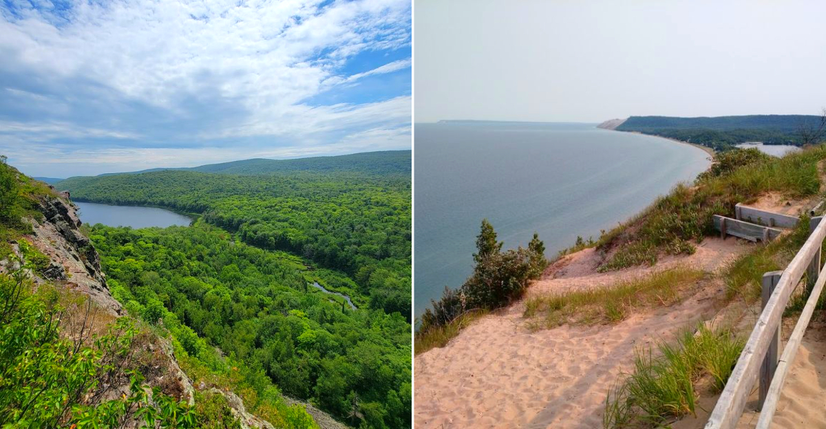
2. Escarpment Trail To Lake Of The Clouds (Porcupine Mountains Wilderness State Park)
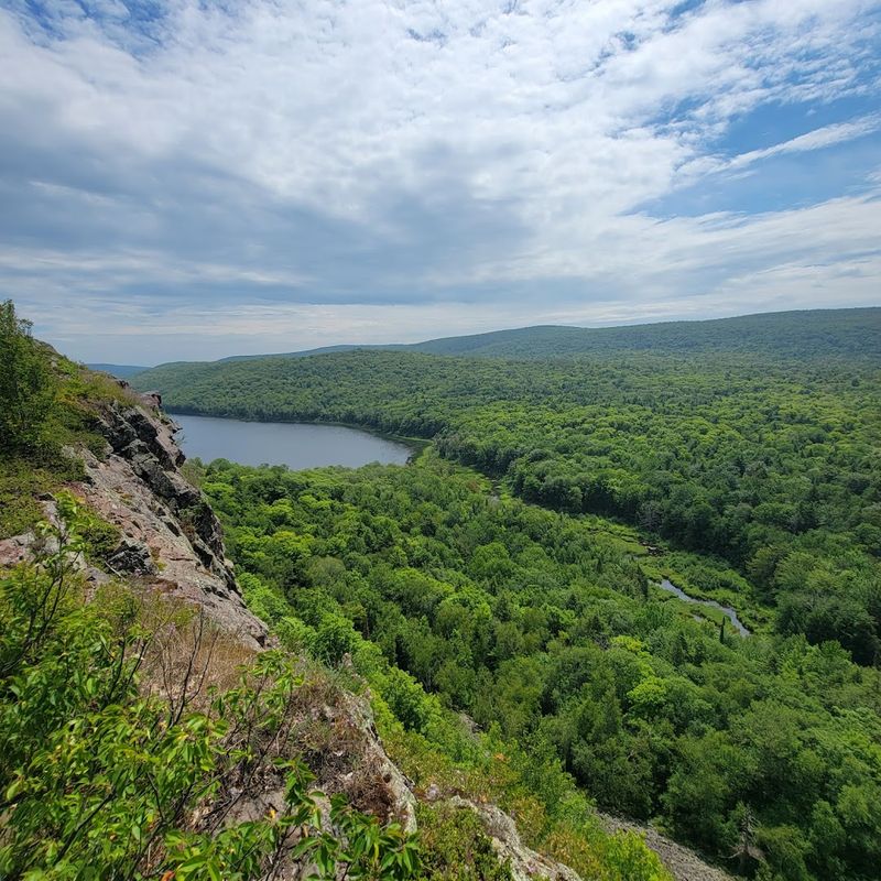
There is a moment on the Escarpment Trail where the world feels suddenly vertical, as basalt ribs lift you high above a green lake shaped like a sleeping apostrophe.
This is the heart of the Porcupine Mountains Wilderness State Park, where hawks surf the thermals at eye level. The path toggles between the high-friction grip of bedrock and the needle-soft duff of the hemlock groves.
This landscape was born of ancient lava flows, and the geology here reads like an open textbook in large print. Back in the 1930s, the Civilian Conservation Corps helped open the viewpoints that feel entirely inevitable once you see them.
The most common approach is to start from the Lake of the Clouds overlook, but for those seeking bigger solitude, stretching your hike further east along the ridge is the way to go.
The rock surfaces can be remarkably slick after a rain, so bringing along a pair of trekking poles is a smart move for your knees and your balance. Clouds move quickly off Lake Superior here, creating a flicker-show of light and shadow over the valley.
3. Greenstone Ridge Trail (Isle Royale National Park)
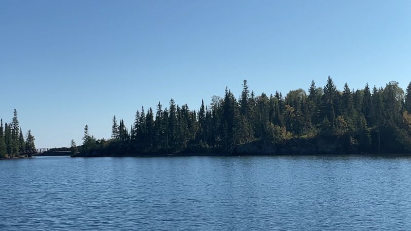
True silence is a rare commodity these days, but on the Greenstone Ridge Trail, the quiet is layered with the haunting calls of loons and the rhythmic clack of trekking poles on ancient bedrock.
The ridge runs like a jagged spine down the center of Isle Royale National Park, Michigan’s only national park and a remote island fortress in Lake Superior.
From the high points, you’re granted glimpses of both the north and south shorelines, with inland kettle lakes appearing as bright as dropped coins in the forest below.
The breezes here smell like balsam fir and sun-warmed lichen, and the nights are so dark they offer a starfield clarity that feels almost hallucinatory.
The Greenstone glacial remnants underfoot echo the ancient Anishinaabe trade routes and the lonely histories of the lighthouses that guard the island’s perimeter.
Moose browse signs, stripped bark and snapped twigs, regularly appear in the damp meadows, while the island’s famous wolves remain a matter of scientific study and sheer luck to witness.
A network of rustic shelters and tent sites anchors a measured, multi-day rhythm for backpackers who want to cross the island from end to end. The days feel structured by distance and weather, and the nights feel structured by darkness and water.
4. Empire Bluff Trail (Sleeping Bear Dunes National Lakeshore)
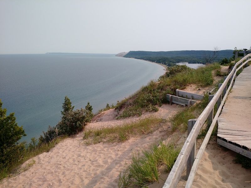
There is a gentle, anticipatory creak to the boardwalks on the Empire Bluff Trail just before the hardwood forest parts and the lake takes over the entire horizon.
The bluff hangs 400 feet above brilliant blue water and tawny dune folds, delivering an easy 1.5-mile walk with a heart-drop view.
Robins fuss in the leafy understory, and in May, the breeze tastes faintly like cool lake sand and wild lilac. It is perhaps the highest reward-to-effort ratio of any hike in the Lower Peninsula.
These dunes are a living, breathing system, and you can see blowouts migrating over time, with footprints becoming part of the erosion math.
The National Park Service has built strategic railings to curb edge creep and protect fragile dune grass, a modest fix that preserves the bluff for the next generation.
For the most cinematic experience, head up about an hour before sunset when lake gradients turn from turquoise to painterly gold.
Keep kids within arm’s reach at the overlook, the drop-off is much steeper than it looks from the trail.
5. Pyramid Point Trail (Sleeping Bear Dunes National Lakeshore)
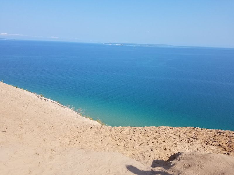
The approach through beech and maple forest feels gentle and shaded until trees slip away and the world opens into a plunging view of Lake Michigan. At Pyramid Point, water shifts from shallow teal to deep, mysterious cobalt, with the Manitou Islands sitting like green sentinels on the horizon.
Juniper bushes and beach grass frame the lookout point, and gulls etch white loops far below your boots. The sandy rhythm of the climb leaves your calves humming in a friendly, I did something today kind of way.
Once used as a navigational landmark by Anishinaabe travelers and later mapped by government survey crews, the hill’s name suits its sharp, geometric presence. Park managers have placed clear signposts at the top to deter hikers from attempting the dangerously steep descent to the water.
Once you start sliding down a 300-foot sand face, getting back up becomes a grueling, multi-hour ordeal. Erosion here is not theoretical, it is visible and daily. Bring steady, closed-toe shoes to handle the occasional hidden root and resist the siren call of the sand-drop.
6. Jordan Valley Pathway Loop (Jordan River Valley, Antrim County area)
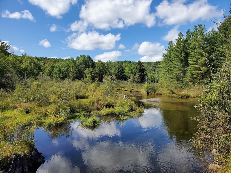
The cold breath of the river lingers over boardwalks while brook trout slip through tea-colored water like quick, dark shadows.
The Jordan Valley Pathway is an 18-mile loop through cedar swamps, vibrant upland hardwoods, and high overlooks where the river braids into bright, silver ribbons below. Songbirds provide a constant soundtrack in the canopy, and in late summer, mushrooms stud the damp forest floor like natural punctuation marks.
Protected as Michigan’s first Natural River, the Jordan holds a long conservation history tied to careful logging retreats and ongoing habitat restoration work. Old Civilian Conservation Corps traces still pop up on ridgelines if you know what to look for.
Rustic campsites at the halfway point, such as Pinney Bridge, keep the loop feeling like a classic backpacking trip where you earn your morning coffee. The rhythm is old-school, and the reward is real. Expect slick, mossy planks after rain and mosquitoes that absolutely mean business during June.
Because the valley holds moisture, a good water filter is worth its weight in gold. I like to hike the loop clockwise on day one to bank the biggest elevation gains early while legs are fresh.
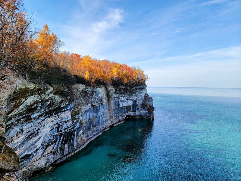
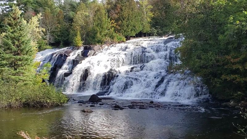
7. Upper To Lower Falls Trail System (Tahquamenon Falls State Park)
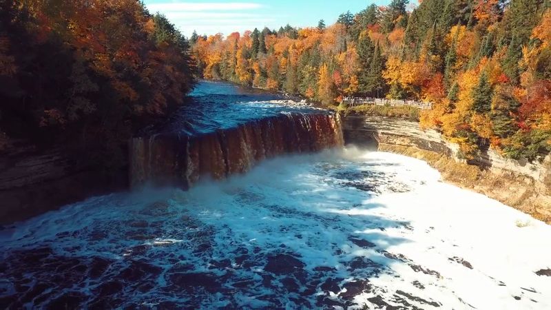
The river runs a deep, translucent tea-brown, stained by tannins from cedar and hemlock swamps, and it throws a permanent, refreshing mist at the Upper Falls.
Wooden stairs drum underfoot as you descend toward the brink, and boardwalks bend you close enough to the 50-foot drop to taste the spray without losing your hat to the wind.
Between the massive Upper Falls and the gentler Lower Falls, the four-mile trail offers quiet forest sections that reset the ears after the roar. The in-between stretches matter as much as the overlooks.
Long before gift shops and breweries, this river corridor moved timber and countless stories through the eastern Upper Peninsula. The park has built robust, high-capacity overlooks to handle summer crowds while keeping ancient tree roots covered and protected.
Look closely at the railings and you can see scars from decades of leaning elbows belonging to people mesmerized by the Root Beer Falls. It’s a small physical record of a shared pause.
The best way to experience the park is to link the two falls with a through-hike and then reward yourself with a local snack near the Lower Falls.
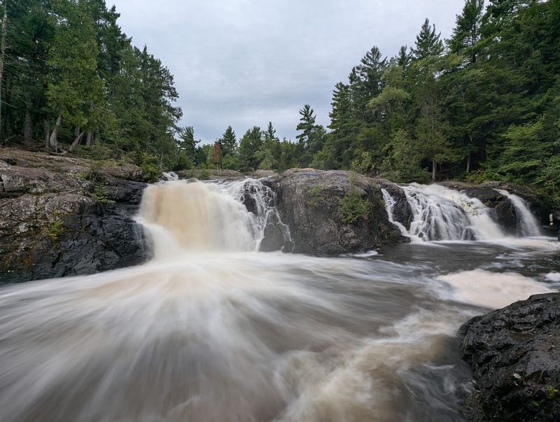
8. Bond Falls Scenic Loop And Overlooks (Bond Falls Scenic Site, Near Paulding)
Water fans out across a staircase of dark rock, each tier shouldering another sheet of white noise. Spray gardens moss and grasses into a soft green fringe, and the boardwalk guides you to framed vantages without trampling the banks. The air feels cooler by several hopeful degrees.
Developed thoughtfully, the site balances access with protection, a rare win for both ankles and orchids. Hydropower history hums upstream, modest and practical. The engineered overlooks have just enough give to feel alive underfoot.
Arrive early for tripod room if you love long exposures. The loop is friendly for mixed abilities, though edges can be damp. Autumn saturates the scene, but overcast summer mornings deliver that silvery waterfall glow.
9. Dead River Falls Trail (Near Marquette)
Boots scrape gneiss and roots as the path hops from cascade to cascade, each drop louder than the last. The gorge feels pocketed and close, with spray cooling the back of your neck on uphill moves. Pines filter light into vertical bars that slide as clouds pass.
Marquette’s mining past sits just upstream in the region’s identity, but this stretch feels defiantly untamed. There is minimal handholding infrastructure, only rough cut routes and worn-in choices. Locals treat it like a workout with scenery.
Mind your footing and expect to get a little muddy. After rain, rocks turn slick and the river throws a heavier voice. Park discreetly where allowed and keep dogs leashed for cliff edges.
10. Sleeping Bear Point Trail From The Dune Climb (Sleeping Bear Dunes National Lakeshore)

Sand sings underfoot, a dry whisper that changes pitch with each ridge crest. Heat shimmers over a pale sea of ripples while the lake lures from far off with a hard blue line. The Dune Climb starts almost playfully, then the scale sneaks up on legs and lungs.
This moving desert owes its shape to wind working glacial leftovers, with the Park balancing play and preservation through marked posts. Rescue stories exist for a reason. Shade is wishful thinking here.
Carry more water than seems reasonable and set a turnaround time. Barefoot feels fun until midday grit bites, so bring sandals. Early morning grants forgiving temperatures and footprints that look like a fresh conversation.
11. Hunter’s Point Shoreline Trails (Copper Harbor)
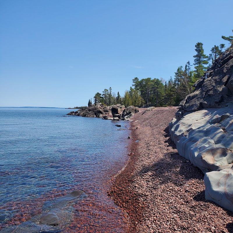
Pebbles click in the wash while a narrow path threads spruce, then spits you onto wave-wet cobbles. The Keweenaw light feels metallic in the best way, sharpening colors of basalt and beach pea blooms. Small coves offer wind breaks that smell like cold pennies and pine.
Mining-era remnants sit across the harbor, history never far from the map here. The township protects this spit with simple wayfinding and gentle maintenance. Locals walk it at all seasons as if checking the lake’s mood.
Short loops make it easy to match weather windows. Bring layers because Superior can flip the thermostat without warning. On calm evenings, linger for alpenglow tipping the rocks a quiet rose.