9 Peaceful Colorado Backroads Where Every Turn Feels Like A Postcard View
Colorado hides some of the most stunning backroads in America, tucked away from the crowded highways and bustling tourist spots.
These winding routes showcase golden aspens, towering peaks, wildflower meadows, and valleys that look straight out of a painting.
If you crave solitude and scenery that makes your jaw drop at every bend, these peaceful drives will deliver exactly that.
1. Last Dollar Road
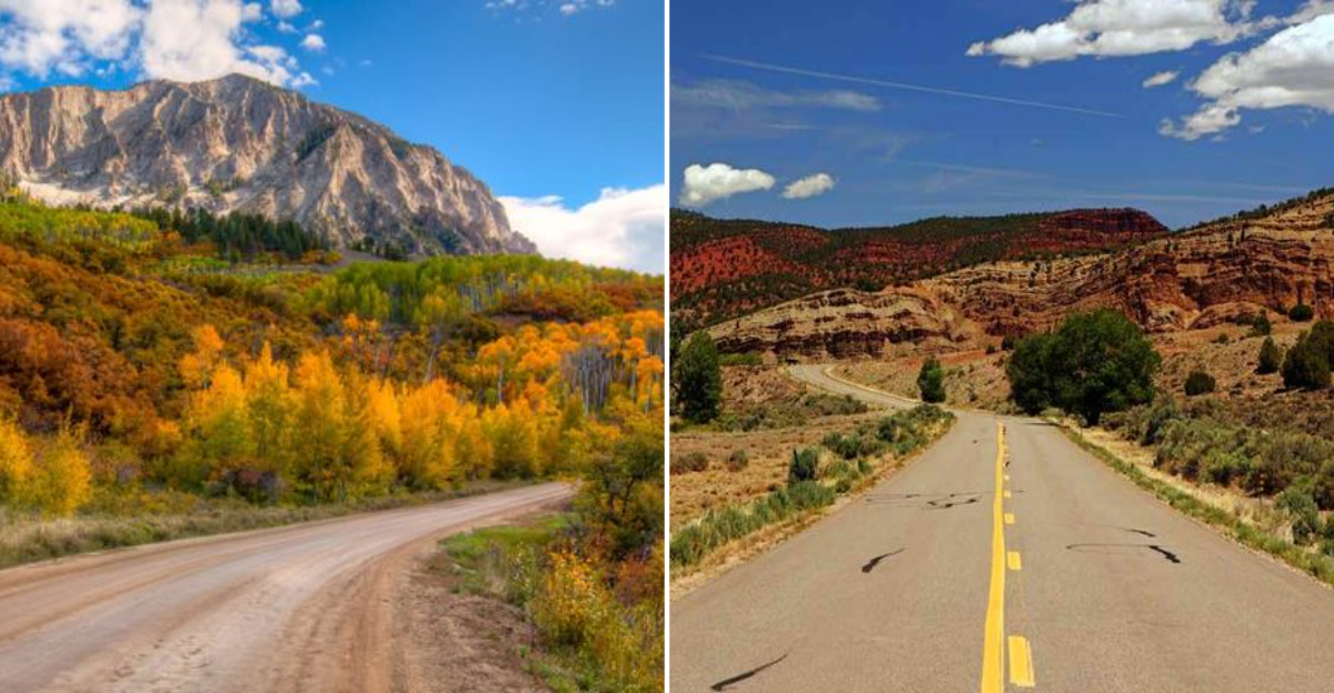
Connecting Ridgway to Telluride (with easy access from CO-145 near the Telluride airport), this high-altitude route offers sweeping views of the San Juan Mountains and Wilson Peak. The name supposedly comes from a miner who spent his last dollar on a claim here.
Gravel surfaces wind through aspen groves and open meadows dotted with old ranches. Late September brings peak fall colors that rival any scenic drive in the state.
The road climbs to about 10,000 feet, so the weather can change quickly. Pack layers and check conditions before heading out, especially in shoulder seasons.
2. Kebler Pass Road
Autumn transforms this route into a golden wonderland, with one of the largest aspen groves in the United States lining both sides. The road stretches between Crested Butte and Paonia, reaching an elevation of 10,007 feet at the summit.
Summer brings wildflowers that carpet the meadows in purple, yellow, and pink. The unpaved surface stays smooth enough for most vehicles during dry conditions.
You can stop at several pullouts to snap photos or enjoy a picnic surrounded by nature. Wildlife sightings are common, so keep your camera ready for elk or deer.
3. Owl Creek Pass Road
This lesser-known gem connects Ridgway to Silver Jack Reservoir, climbing through forests and alpine basins. At 10,114 feet, the summit rewards drivers with panoramic views of Chimney Rock and Courthouse Mountain.
The gravel road suits high-clearance vehicles best, though careful drivers manage in standard cars during summer. Wildflowers bloom abundantly in July, painting the hillsides with color.
Few tourists venture here, making it ideal for peaceful exploration. Bring binoculars for spotting hawks and eagles soaring above the ridgelines.
4. Boreas Pass Road
History meets scenery on this former railroad grade that crosses the Continental Divide at 11,481 feet. The route connects Breckenridge to Como, following the old Denver, South Park and Pacific Railroad bed.
Old section houses and remnants of the railway days dot the landscape, offering glimpses into Colorado’s mining past. Panoramic views span across South Park and the Tenmile Range.
Summer opens the road to regular vehicles, though snow lingers until late June at higher elevations. Fall brings vibrant aspens and cooler temperatures, perfect for hiking nearby trails.
5. Guanella Pass Road
Linking Georgetown to Grant, this paved byway climbs to 11,669 feet through subalpine forests and tundra. Mountain goats often wander near the summit, seemingly unbothered by passing cars.
The route provides access to numerous hiking trails, including paths to several fourteeners. Clear days reveal views stretching across multiple mountain ranges.
Paved surfaces make this drive accessible to all vehicles during summer and early fall. Arrive early on weekends to secure parking at popular trailheads and avoid afternoon thunderstorms that roll in regularly.
6. Cottonwood Pass
Crossing the Sawatch Range at 12,126 feet, this paved pass connects Buena Vista to Gunnison through stunning alpine terrain. The route ranks among Colorado’s highest paved roads, staying above treeline for miles.
Tundra wildflowers bloom in late July, creating colorful carpets across the rocky slopes. Views extend across the Taylor Park Reservoir and surrounding peaks.
Snow closes the road from October through May, so plan accordingly. The drive takes about an hour, but budget extra time for photo stops and short walks to viewpoints.
7. Phantom Canyon Road
Following an abandoned railroad grade, this narrow road winds through a dramatic canyon between Canon City and Victor. Sheer rock walls tower overhead while Eightmile Creek runs alongside the route.
The one-lane gravel track requires careful navigation and patience when meeting oncoming traffic. Historic railroad tunnels and trestles add character to the journey.
Spring runoff creates impressive waterfalls cascading down the canyon walls. Check road conditions before attempting this drive, as washouts occasionally close sections temporarily.
8. Gold Camp Road
Once a railroad serving Cripple Creek’s mining district, this scenic route now provides stunning views from Colorado Springs to Victor. The road climbs through ponderosa pine forests before opening to mountain vistas.
Several tunnels punctuate the journey, though some remain closed for safety. Pullouts offer opportunities to gaze across the plains stretching eastward.
The lower portions stay accessible year-round, while the upper sections close during winter. Mountain bikers and hikers share this route, so watch for non-motorized traffic around blind curves.
9. Colorado River Road
Following the Colorado River between Dotsero and McCoy/State Bridge in Eagle County, this dirt-and-chip route threads ranchlands and river bends with wide-open mountain backdrops.
It’s a mellow drive in dry conditions that keeps you close to the water nearly the whole way.
Pull over at river access points to watch boaters or cast for trout, and keep an eye out for wildlife in the willows. The scenery shines in late summer and fall when the cottonwoods and hillsides light up.
Note that this is a separate drive from the Colorado River Headwaters Byway near Grand Lake; this stretch sits far to the west along County Road 301.