14 Scenic Drives In Arizona That Are Perfect For Road Trips
Arizona packs more driving drama into one state than most regions manage across a dozen. Saguaro deserts morph into alpine forests, red-rock canyons give way to painted badlands, and every bend delivers a new postcard moment.
Road trips here feel like flipping through a geology textbook written by someone with a serious sense of adventure. I dont need to say anything more.
Just buckle up and let the asphalt guide you through landscapes that look like they were designed by a committee of artists who couldn’t agree on a single color palette.
1. Red Rock Scenic Byway (SR-179, Sedona)
Cathedral spires in crimson tower over this All-American Road, turning every mile into a photo opportunity you will absolutely pull over for.
SR-179 runs compact and punchy, delivering Sedona’s signature geology without demanding an entire day.
Trailheads pop up at regular intervals, inviting quick hikes among the formations. The road itself curves gently, making it easy to admire Bell Rock and Courthouse Butte without white-knuckling the wheel.
Pullouts are plentiful, so you can frame that perfect shot or simply sit and soak in the rust-toned majesty. Sedona’s magic feels concentrated here, accessible and immediate.
2. Oak Creek Canyon (US-89A, Flagstaff to Sedona)
Pine country surrenders to red rock as US-89A snakes downward through one of Arizona’s most photogenic canyons. About 15 miles of switchbacks, overlooks, and creek-side charm keep your eyes busy and your camera ready.
Start at Oak Creek Vista for a panoramic preview, then descend into cool shade where swimming holes beckon on hot afternoons. Fall color explodes here when cottonwoods and oaks turn gold against the canyon walls.
Pullouts appear frequently, each offering a slightly different angle on the creek or cliffs. This drive feels like a slow reveal, peeling back layers of landscape with every curve.
3. Desert View Drive (SR-64, Grand Canyon South Rim)
Twenty-three miles of rim-hugging asphalt connect Grand Canyon Village to Desert View, stringing together some of the South Rim’s most jaw-dropping viewpoints.
This is the classic Grand Canyon road trip, open to private vehicles year-round when the weather cooperates.
Each pullout unveils a fresh perspective on the canyon’s immense architecture, from layered rock walls to the distant ribbon of the Colorado River.
Desert View Watchtower anchors the eastern end, offering 360-degree panoramas and a bit of history.
Plan extra time because you will stop more often than you expect. The canyon has a way of demanding repeated viewings.
4. Hermit Road (Grand Canyon South Rim)
Seven miles, nine overlooks, and horizons that stretch into forever make Hermit Road a South Rim essential.
Most of the year, you will ride the free shuttle or pedal a bike, but private vehicles roll in during the winter months of December through February.
Each stop along this westward route offers a distinct vantage point, from Hopi Point’s sunrise magic to Hermits Rest’s stone architecture. The road hugs the rim tightly, keeping the canyon always within view.
Shuttle stops are well spaced, allowing you to hop off, explore, and catch the next bus without stress. This drive rewards slow exploration.
5. Kaibab Plateau North Rim Parkway (AZ-67)
Tall pines flank this forested corridor leading to the Grand Canyon’s quieter North Rim, a seasonal road that closes with winter snow and reopens when conditions allow. Always verify status before heading out, as access dates shift year to year.
The drive feels like cruising through a mountain sanctuary, with meadows opening occasionally to frame distant peaks. Wildlife sightings are common, especially deer and wild turkeys moving through the undergrowth.
Elevation climbs steadily, cooling the air and changing the vegetation as you approach the rim. This route trades crowds for solitude, delivering a different flavor of Grand Canyon grandeur.
6. Catalina Highway Sky Island Scenic Byway (Mt. Lemmon, Tucson)
Saguaro cacti give way to towering pines in less than an hour as this paved ribbon climbs nearly 7,000 feet up Mt. Lemmon. Each mile introduces a new climate zone, turning a simple drive into a botanical time machine.
Pullouts dot the route, offering views back over the Tucson basin or into alpine meadows above. The temperature drops noticeably as you ascend, making this a favorite escape when the desert floor sizzles.
Birdwatchers and photographers find endless subjects along the way, from low-desert hummingbirds to high-elevation jays. This sky island experience compresses ecosystems into a single, spectacular ascent.
7. Coronado Trail National Scenic Byway (US-191, Clifton to Springerville)
Roughly 460 curves stretch across 120 miles of US-191, earning this route its reputation as Arizona’s ultimate roller-coaster drive.
Copper mining country near Clifton gives way to 9,000-foot forests as the road climbs, twists, and occasionally makes you giggle at its audacity.
Take your time and enjoy the sweepers, the overlooks, and the sheer variety of landscapes. Elk graze in mountain meadows, and aspens blaze gold in autumn against evergreen slopes.
This byway demands patience and rewards it generously. Plan a full day to savor every switchback and scenic pullout along the way.
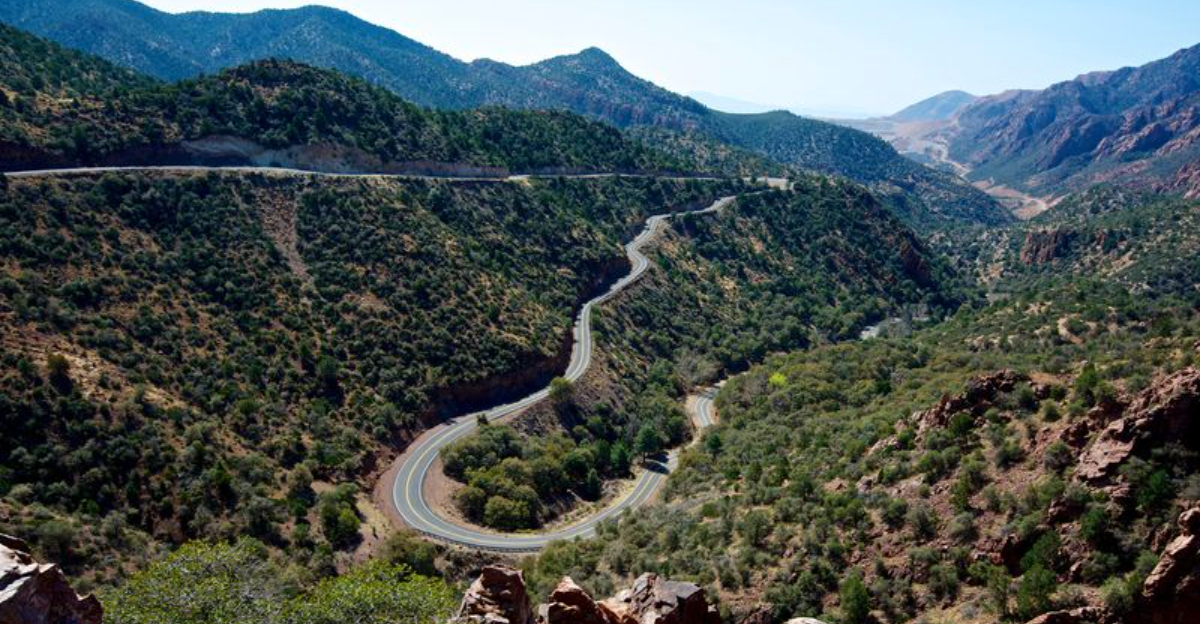
8. Salt River Canyon (US-60, Globe to Show Low)
Towering walls and an elegant bridge make the Salt River Canyon feel like a mini Grand Canyon, with the added bonus of a river humming through the bottom.
US-60 descends steeply into the gorge, then climbs back out on the far side, offering pullouts where you can pause and admire the geology.
Daylight driving shows off the layered rock and the play of light across the canyon faces. The bridge itself is a marvel, arching gracefully over the water far below.
This section of highway packs drama into a relatively short stretch, making it a highlight of any cross-state journey.
9. Mogollon Rim Road (Forest Road 300, near Payson)
A graded forest road traces the edge of the Mogollon Rim’s dramatic thousand-foot escarpment, delivering long-view panoramas and excellent chances to spot elk at dusk.
FR-300 runs for miles along the rim, with pullouts inviting you to step out and peer over the edge.
Seasonal access varies with snow and moisture, so always check conditions before committing to this route. When open, the road feels remote and peaceful, with ponderosa pines framing every vista.
Sunsets here paint the valley below in shades of amber and violet, a spectacle worth timing your drive to catch.
10. Desert to Tall Pines Scenic Road (SR-288, Roosevelt Lake to Young)
Mostly unpaved and thoroughly stunning, SR-288 climbs from Roosevelt Lake’s saguaro-studded shores into cool ponderosa highlands around Young.
This backroad classic rewards high-clearance vehicles and adventurous spirits with landscapes that shift dramatically mile by mile.
Expect dust, washboard sections, and grins that last long after you hose off the vehicle. The slow pace lets you notice details: wildflowers, rock formations, and the way the air changes as you gain elevation.
Plan extra time and bring water, snacks, and a camera. This drive feels like a secret Arizona is letting you in on.
11. Swift Trail Parkway (AZ-366, Mount Graham, near Safford)
Switchbacks haul you more than 7,000 vertical feet from Sonoran cactus into alpine meadows, compressing a Mexico-to-Canada ecosystem journey into a single afternoon.
AZ-366 winds up Mount Graham with drama and beauty in equal measure, delivering one of Arizona’s most extreme elevation drives.
Unpaved sections near the summit require caution, so check conditions before attempting the full route. The views expand with every hairpin turn, revealing valleys, peaks, and the distant sprawl of the desert floor.
Pack layers because the temperature at the top feels like a different season entirely. This drive is a climate adventure.
12. San Francisco Peaks Scenic Road (US-180, Flagstaff toward Snowbowl)
Ponderosa straightaways lead toward the San Francisco Peaks, Arizona’s highest summits, with views that grow more dramatic as you approach the ski area turnoff.
US-180 runs smooth and scenic, a classic fall-color cruise when aspens glow gold against evergreen slopes.
Winter access remains easy when roads are clear, making this a year-round option for mountain scenery. The peaks dominate the skyline, snow-capped much of the year, and are always impressive.
Pullouts offer chances to frame the mountains or explore short trails into the forest. This drive combines accessibility with alpine beauty in true Flagstaff style.
13. Petrified Forest National Park Road (Painted Desert to Rainbow Forest)
Twenty-eight miles of moonscapes, badlands, and ancient fossil wood stretch between the Painted Desert and Rainbow Forest, all accessible via the park’s through road.
This drive feels like cruising across another planet, with colors and formations that defy everyday geology.
Allow a couple of hours to stop at overlooks and take short walks among the petrified logs. Each pullout reveals a different facet of this strange, beautiful landscape, from striped hills to crystallized trees.
The road connects I-40 to US-180, making it a convenient and spectacular detour on longer road trips across northern Arizona.
14. Apache Trail (SR-88, Superstition Mountains)
Clifftop curves hug canyon lakes through the rugged Superstition Mountains, where history and scenery collide on one of Arizona’s most storied routes.
A key unpaved section has reopened, but other segments see scheduled midweek closures, so always check ADOT before committing to the full trail.
Canyon Lake and Apache Lake shimmer blue against the desert backdrop, offering recreation and breathtaking views. The road narrows and climbs in places, adding a touch of adventure to the journey.
This trail rewards flexible planning and a spirit of exploration. When open, it delivers drama and beauty in generous doses.