The Arizona Trail That Leads You To A Ghost Town Few People Know Exists
Tucked away in the rugged desert landscape of central Arizona, the Richinbar Mine and Pueblo Trail offers an adventure that feels like stepping back in time without the crowds that swarm more famous ghost towns.
I stumbled onto this hidden corner of Arizona during a random search for off-the-beaten-path hikes, and what I found was a landscape layered with history, petroglyphs etched by ancient hands, and mining ruins that whisper stories of fortune seekers who worked these hills from 1905 to 1948.
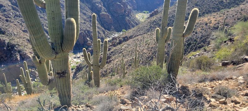
The trail itself winds through terrain overlooking the Agua Fria River, where crumbling stone structures and unmarked graves remind you that real people once called this desolate beauty home.
Arizona hides many secrets, and this elusive trailhead is one. GPS may fail, but the adventure never disappoints.
A Mining Operation Frozen In Time
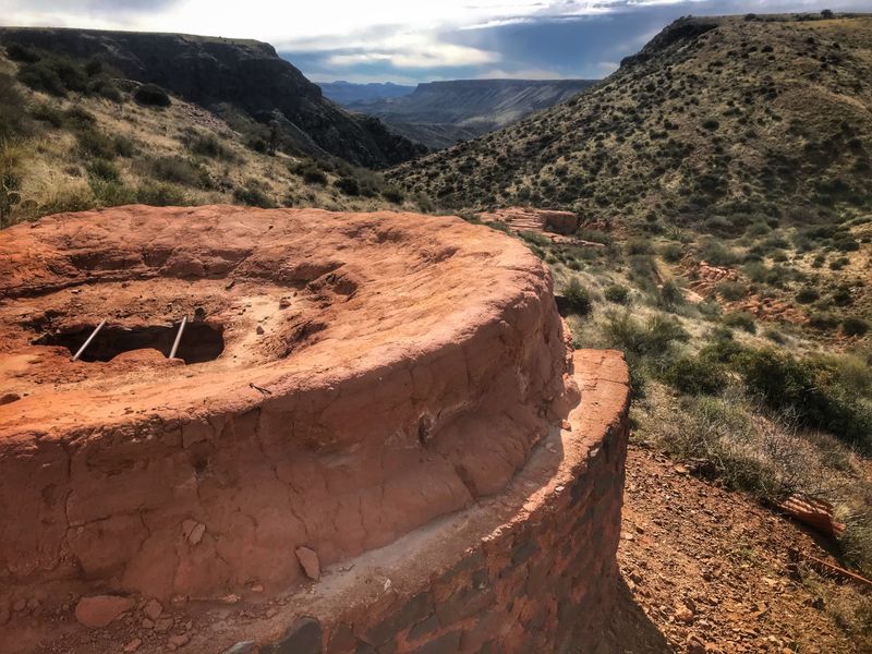
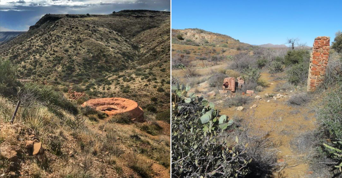
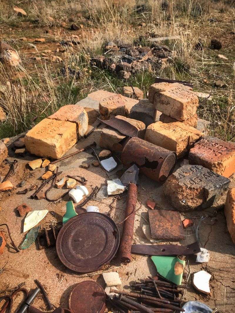
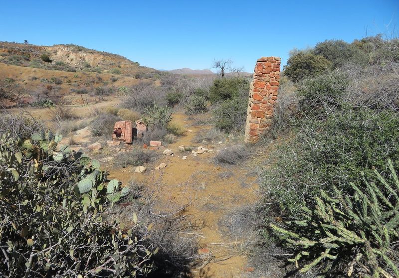
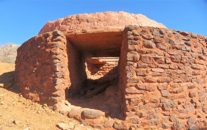
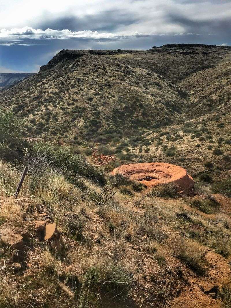
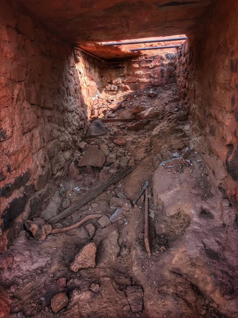
Walking among the scattered ruins of Richinbar Mine feels like wandering through an outdoor museum that nature has been slowly reclaiming for decades.
The mine operated under at least three different companies between 1905 and 1948, each one chasing the promise of copper and other minerals embedded in these desert hills.
Stone foundations mark where buildings once stood, and rusted equipment pokes through the brush, telling silent stories of backbreaking labor in unforgiving heat.
What strikes me most is how exposed everything remains, with mine shafts still open and unfenced, demanding careful attention as you explore. I found myself imagining the clatter of machinery and shouts of miners echoing off these canyon walls during the operation’s heyday.
The setting offers a raw, unfiltered glimpse into Arizona’s mining past without the sanitized interpretive signs you find at more developed historic sites.
Every crumbled wall and abandoned tool scattered across the ground adds another layer to the story of hardship and hope that defined early 20th-century mining camps throughout the Southwest.
Ancient Rock Art Above The Ruins
Long before prospectors arrived with picks and dreams of striking it rich, indigenous peoples left their mark on the rocks above what would become the Richinbar Mine site.
Petroglyphs pecked into the dark desert varnish of boulders overlook the mining ruins, creating a fascinating juxtaposition of two very different chapters in this landscape’s human history.
I spent a good hour scrambling among the rocks, discovering spirals and figures that could be centuries or even millennia old.
The contrast between these ancient symbols and the relatively modern mining equipment scattered below really drove home how many layers of human activity this single spot has witnessed.
Finding these petroglyphs requires some careful observation and a bit of boulder hopping, but the reward is worth the effort.
Respectful viewing is essential since these cultural treasures are irreplaceable and protected by federal law. I recommend bringing binoculars to examine details without touching the rock surfaces, and always remember that these images held deep meaning for the people who created them.
Unmarked Graves And Respectful Exploration
Scattered among the mine ruins are several unmarked graves, humble piles of rocks that serve as sobering reminders of the harsh realities faced by those who worked and lived in this remote location.
These burial sites don’t come with headstones or identifying information, leaving the individuals resting here anonymous to modern visitors.
I found myself pausing at each one, wondering about the stories behind these simple rock cairns and what circumstances brought these people to such a remote corner of Arizona.
The presence of these graves transforms the site from a simple collection of interesting ruins into a place that demands reverence and thoughtful behavior. I made sure to give each burial site a wide berth, never stepping on or disturbing the carefully placed stones.
This aspect of the trail reminds visitors that ghost towns weren’t always abandoned, that real communities with births, deaths, and all the drama in between once thrived in places we now explore as curiosities.
Treating these sites with the dignity they deserve honors the memory of people whose names we’ll never know.
The Tricky Trailhead Hunt
Finding the actual entrance to the Richinbar Mine and Pueblo Trail might be the most challenging part of your entire visit, and I speak from experience after driving past it twice on my first attempt.
GPS coordinates will get you to the general area in Arizona 85324, but most mapping apps overshoot the small parking area by about half a mile, leaving confused visitors wondering where they went wrong.
The parking spot is tiny, barely accommodating a few vehicles, and the entrance requires either squeezing through a narrow cattle gate or climbing over it.
That gate stays closed to keep livestock contained, so don’t leave it open even though it feels like you’re trespassing on private land. I recommend lowering your speed as you approach the coordinates and watching for a small pullout on the roadside rather than trusting your GPS completely.
The slightly complicated access actually works in favor of those who make the effort, keeping crowds minimal and preserving the sense of discovery that makes this trail special. Once you find it, mark the location carefully for future visits.
Agua Fria River Views
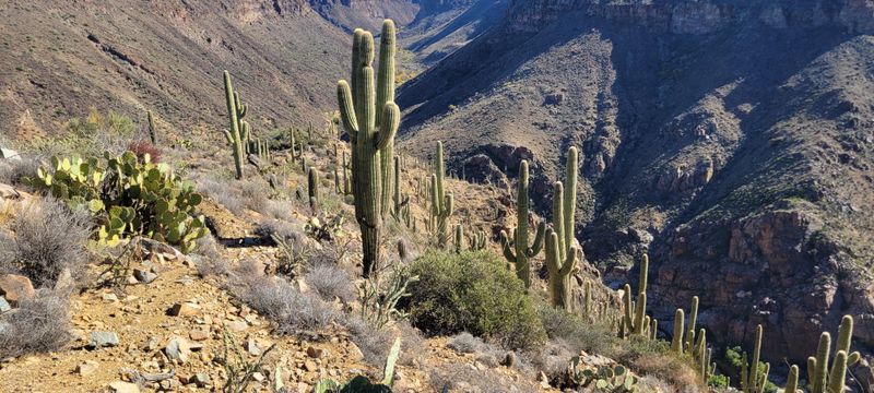
The elevated position of the Richinbar Mine site provides spectacular views across the Agua Fria River corridor, a ribbon of green cutting through the tawny desert landscape below.
Standing among the ruins, I could see why miners chose this particular spot, with its commanding views and proximity to water sources essential for both living and mining operations.
The river valley creates a natural landmark visible for miles, and on clear days, the vista stretches across multiple mountain ranges.
I timed my visit for late afternoon when the setting sun painted the canyon walls in shades of amber and rust, transforming an already beautiful view into something truly memorable.
The contrast between the lush riparian corridor along the river and the surrounding desert highlands illustrates the dramatic ecological diversity packed into Arizona’s central region.
Bringing binoculars enhances the experience, allowing you to spot wildlife along the river and examine distant geological features. These overlooks provide perfect spots for breaks during your exploration, combining rest with scenery that reminds you why Arizona’s landscapes inspire such devotion.
Indian Ruin Sites In The Surrounding Area
Beyond the mine itself, the broader region around the Richinbar site contains major indigenous ruin complexes that add archaeological significance to what might otherwise be just another mining ghost town.
Several reviewers mentioned substantial pueblo ruins scattered throughout the area, though specific locations are often kept quiet to protect these fragile sites from vandalism and unauthorized artifact collection.
During my explorations, I discovered foundation outlines and pottery shards that hinted at substantial pre-Columbian settlements predating European contact by centuries.
The Agua Fria National Monument, which encompasses this region, protects over 450 distinct archaeological sites representing thousands of years of human occupation.
Connecting these ancient communities to the later mining operations creates a rich timeline of human adaptation to this challenging environment.
I recommend researching the area’s archaeological resources before your visit and following all regulations regarding artifact disturbance, which means looking but never collecting.
The combination of prehistoric ruins, historic mining remnants, and petroglyphs makes this area a cultural landscape with remarkable depth for those willing to explore respectfully and thoughtfully.
Safety Considerations And What To Bring
Exploring Richinbar Mine requires more preparation and caution than your typical marked trail, starting with the very real hazard of unfenced mine shafts that could cause serious injury.
I kept my eyes on the ground constantly, watching for both openings in the earth and the less obvious dangers like unstable ground around collapsed tunnels.
The remote location means cell service is unreliable at best, so letting someone know your plans and expected return time isn’t just smart, it’s essential.
Water needs are significant, especially during Arizona’s brutal summer months when temperatures can exceed 110 degrees and shade is practically nonexistent. I carried three liters for a half-day exploration and finished most of it.
Sturdy boots with ankle support help navigate the rocky, uneven terrain, and long pants protect against the thorny desert vegetation that seems to grab at every opportunity. A basic first aid kit, sun protection, and a charged phone with downloaded offline maps round out the essentials.
The trail’s unofficial status means no emergency services are stationed nearby, making self-sufficiency and careful decision-making your best safety tools.
Sunset Approach Through Desert Light
The approach is pure Arizona, with golden light bending through ocotillo and cholla while your footsteps crunch on volcanic gravel. You will pass weathered fence posts, a lone cattle gate, and the bleached ribs of a long gone barn.
Keep your eyes on faint wagon ruts that guide you toward the ridgeline.
As the trail climbs, views widen and silence deepens, broken only by quail and distant coyotes. You will spot rusted cans glinting like breadcrumbs, hinting at lives that once pulsed here.
Arrive at twilight, and the ghost town glows softly, every board and nail telling stories you can almost hear.
The wind carries whispers through broken windows, stirring dust in lazy spirals. Shadows stretch long across the sunbaked earth, turning every corner into a fleeting portrait of the past.
A hawk circles above, its cry echoing off the ridges like a call from another time. Even in stillness, the desert seems alive, holding memories that only the patient and curious can uncover.