The Chilling South Carolina Marsh Route Locals Swear Is Haunted By History
I first heard about this South Carolina route from a shrimper in Charleston who swore he’d never take Parkers Ferry Road after sunset. The ACE Basin sits where three rivers meet the Atlantic, forming one of the largest undeveloped estuaries on the East Coast.
Spanish moss drapes low, the marsh stretches endlessly, and the history runs deeper than the tidal creeks. Locals will tell you the land remembers everything: rice plantations, raids, runaways, and a preacher still searching for his daughter.
US-17 cuts straight through this haunted corridor, and every turnoff has a story that’ll make your skin prickle.
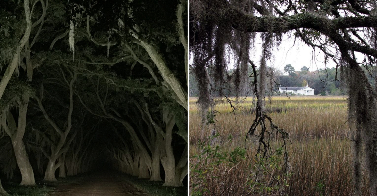
Where the road slips into the marsh
Lowcountry air turns briny as US-17 drifts through the ACE Basin, a vast estuary where the Ashepoo, Combahee, and Edisto rivers braid into miles of spartina.
This corridor sets the tone for a slow, scenic push between Jacksonboro and the sea, with overlooks, boat landings, and wildlife areas right off the pavement.
I rolled down my windows the first time I drove this stretch, and the smell hit me instantly: salt, pluff mud, and something older.
The road doesn’t rush you. It curves gently, letting the marsh unfold on both sides like pages in a history book written in grass and water.
A legend in the pines: Parkers Ferry Road and the Jacksonboro Light
Turn onto Parkers Ferry Road near Jacksonboro after dusk, and locals will tell you to watch for a wandering light.
Stories trace it to a preacher searching for his missing daughter along this lonely stretch. Drivers still report a bobbing glow over the asphalt and swamp.
Folklore runs thick here, but this is the Lowcountry’s most famous ghost road. I’ve never seen the light myself, though I’ve tried twice.
Both times, the silence felt heavy enough to hold, and every rustle in the pines made me grip the wheel a little tighter. Some roads just feel wrong after dark.
Haunted by history at the Combahee River
Roll back to US-17 and cross the Harriet Tubman Memorial Bridge. Here, in June 1863, Tubman helped lead a Union raid that freed more than seven hundred enslaved people along the river’s rice plantations.
The bridge and boat landing mark a landscape that still looks wide, tidal, and eerily quiet.
Standing at the landing, I felt the weight of what had happened here. The river moves slow, but it carried so many people to freedom. You can almost hear the oars cutting water if you listen long enough.
This place doesn’t shout its history. It whispers it across the current.
Marsh drives that whisper
Side roads and levee loops thread former rice fields where herons lift like scraps of cloud.
Donnelley and Bear Island Wildlife Management Areas offer self-guided driving routes and pull-offs where you can idle beside alligator-stitched water and the rattle of marsh grass.
I spent an hour parked at one of these pull-offs, engine off, watching a great blue heron stalk the shallows. The silence wasn’t empty. It buzzed with insects, bird calls, and the soft hiss of wind through spartina.
These drives demand patience, but they reward it with views that feel untouched by time or traffic.
A walk under cypress: Edisto Nature Trail
Pause in Jacksonboro for a short loop through pine and bald cypress that edges a tributary of the Edisto.
Boardwalk planks tap underfoot, and the swamp settles around you like a breath held. It’s a quick, good leg-stretch right on the route.
The trail took me maybe twenty minutes, but it felt like stepping into another century. Cypress knees poked up through dark water, and somewhere deep in the trees, a woodpecker hammered out a rhythm.
I didn’t see another soul. Just me, the swamp, and the kind of stillness that makes you forget your phone exists.
The finale drive to the sea: SC-174
On Edisto Island, SC-174 becomes the Edisto Island National Scenic Byway, a canopied ribbon of road opening to sweeping marsh views, meandering creeks, and tide-cut flats that glow at golden hour.
The designated byway runs about seventeen miles to the beach.
This is where the route earns its reputation. Trees arch overhead, filtering sunlight into golden stripes across the pavement. Then the canopy breaks, and suddenly you’re surrounded by marsh that stretches to the horizon.
I drove it twice in one day just to catch the light at different angles. Worth every extra mile.
What the landscape remembers
The hush here is not empty. These marshes once held a dense network of rice plantations. Tides still move through old embankments, and great flocks stitch the sky along a corridor that rewards quiet driving and careful looking.
I stopped at a pull-off and studied the marsh, trying to imagine what it looked like two hundred years ago. The land doesn’t forget. You can still see the faint outlines of levees and canals if you know where to look.
Birds wheel overhead in patterns that feel ancient, and the water keeps its secrets close. History soaks every acre.
How to drive it well
Daylight shows wildlife best, but twilight brings the mood. Fuel up earlier, carry insect repellent, and mind posted signs since much of the land remains private. Shoulders are narrow, so use designated pull-offs for photos and give wildlife a wide berth.
I learned the hard way that gas stations are scarce once you leave Jacksonboro. Fill your tank, pack water, and don’t expect cell service in the deeper stretches. The mosquitoes are legendary, so bug spray is non-negotiable.
Respect the land, stay on marked roads, and let the alligators have their space. This route is best savored slowly.