The North Carolina Scenic Highway Locals Call Their ‘Secret Route To Heaven’
Last summer I took a wrong turn near Franklin and stumbled onto a stretch of asphalt so stunning I circled back twice just to soak it in again.
North Carolina Highway 28, better known as Moonshiner 28, winds 103 miles through waterfall-dotted gorges, past glassy lakes, and under canopies so thick they filter sunlight into gold ribbons.
Locals guard this route like a family recipe, preferring its quiet curves to the elbow-to-elbow traffic clogging the Blue Ridge Parkway. It is time to experience their magic.
Moonshiner 28: A Quieter Mountain Ribbon Through Waterfall Country
Stretching roughly 103 miles from Deals Gap through Franklin and Highlands before slipping into Georgia and South Carolina, NC Highway 28 dodges the tourist stampede while delivering every ounce of mountain drama.
The nickname Moonshiner 28 hints at its bootlegger past, when narrow switchbacks and hidden hollows made it perfect for late-night runs.
Today, those same curves reward drivers with lake overlooks, roadside cascades, and pull-offs so peaceful you can hear birdsong over your engine.
I remember parking at a random turnout and realizing I had an entire waterfall to myself on a Saturday afternoon.
If solitude and scenery rank higher on your checklist than gift-shop clusters, this is your road.
Where It Runs and the Stretch You’ll Love Most
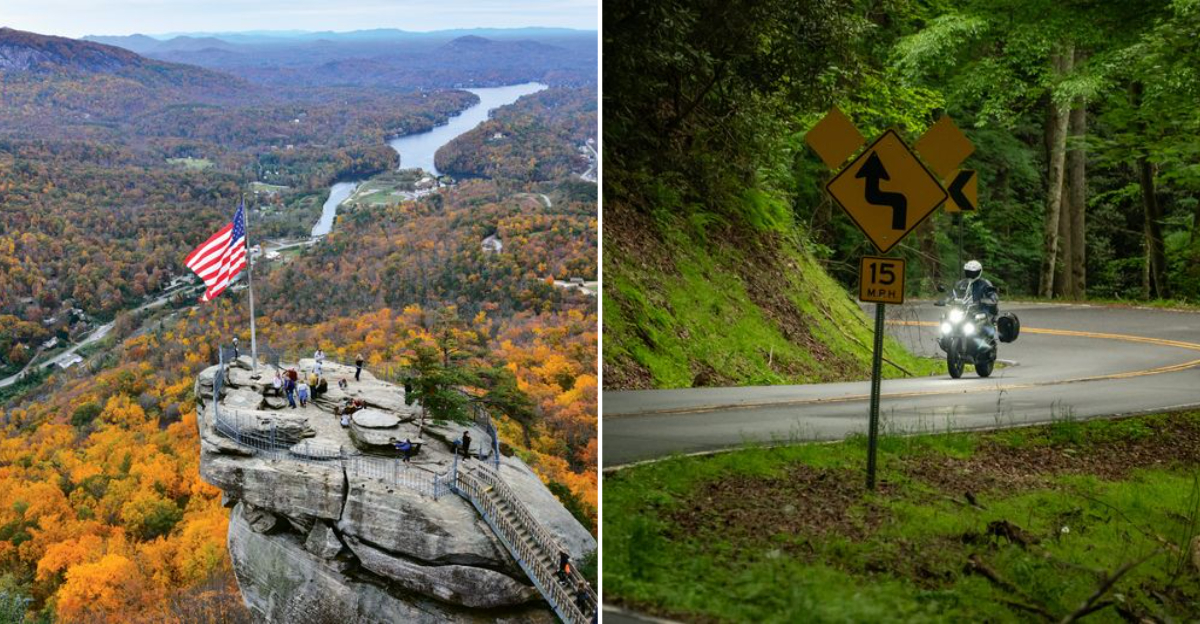
The crown jewel segment links Franklin and Highlands, where NC-28 merges with US-64 through the Cullasaja Gorge inside Nantahala National Forest.
Here, pavement clings to cliff faces so tight you feel like you are threading a needle made of granite and rhododendron.
Short pull-offs appear every half-mile, each framing a view that makes you reach for your camera before you even kill the ignition. On my first run I counted eleven stops in twelve miles, and I still missed a few.
The gorge section compresses waterfalls, overlooks, and hairpin turns into a twenty-mile masterclass in Appalachian beauty, making it the must-drive core of the entire route.
Waterfall Trifecta Right Off the Highway
Stack three classics in one afternoon: Dry Falls lets you walk a paved trail behind a curtain of water without getting soaked, Bridal Veil Falls now welcomes foot traffic only after the drive-through lane closed for safety, and Cullasaja Falls roars into view from roadside pull-offs with zero hiking required.
For a bonus dip, locals point adventurous swimmers toward Quarry Falls, nicknamed Bust-Your-Butt Falls for its slick approach.
I tested that nickname personally and can confirm the rock is as slippery as buttered ice.
Check flow conditions before jumping in; spring runoff turns gentle pools into washing machines, and nobody wants a tumble down a gorge.
Why Locals Pick It Over Busier Byways
Compared with marquee routes like the Blue Ridge Parkway, Moonshiner 28 trades bumper-to-bumper leaf-peepers for elbow room and fresh air.
Magazines and rider guides quietly tout it as a secret two-lane threading lakes, overlooks, and cascades between Robbinsville, Franklin, and Highlands.
Residents appreciate the breathing space; you can actually pull over for a photo without blocking a caravan or dodging selfie sticks.
One Franklin shopkeeper told me she sends visitors here when they complain about Parkway traffic, and most come back grinning.
The scenery rivals any famous drive, but the crowd factor stays refreshingly low, especially on weekdays and outside peak fall color windows.
Best Seasons and Real-World Timing
Spring awakens wildflowers and pumps waterfalls to full volume, while late September through October paints the gorge in crimson, gold, and amber that looks Photoshopped until you see it in person.
Winter keeps the road open most days, but shaded rock cuts and waterfall spray zones collect ice faster than you can say black ice.
Curves plus frost demand slow speeds and steady nerves; I once crept through a January morning at fifteen miles per hour and still felt my pulse climb.
Plan extra time in fall, arrive early to claim parking at popular falls, and always check mountain weather forecasts before you roll out.
Side Trips a Few Minutes Off NC-28
Pop out to Fontana Dam, where you can walk or drive across the Tennessee Valley Authority giant and peer down at the turquoise reservoir 480 feet below.
Near Robbinsville, the Joyce Kilmer Memorial Forest preserves old-growth giants, some topping 100 feet and predating European settlement.
Both detours add less than an hour round-trip and deepen your day with engineering marvels and ancient trees that put modern life in perspective.
I spent twenty minutes at Fontana just watching mist rise off the lake, and it felt like hitting a mental reset button.
Pack a lunch; these spots offer picnic tables and solitude in equal measure.
Drive It Safely Because the Gorge Is Tight
Pull fully into signed turnouts for photos, mind blind curves, and expect wet pavement near waterfalls where mist settles year-round. At Bridal Veil, the old drive-under lane is permanently closed to cars for safety; pedestrians only now.
At Quarry Falls, heed local cautions about water depth and flow before you wade in; what looks knee-deep can hide submerged boulders and sudden drop-offs. I watched a confident swimmer nearly lose his footing when a hidden current grabbed his legs.
Use Franklin or Highlands for food, lodging, and fuel; services between towns are sparse, so top off your tank and your snack bag before committing to the curves.