These Peaceful Arkansas Backroads Are Perfect For A Slow Scenic Escape
Some roads are built for getting it over with. These roads make you glad the trip is taking longer.
Arkansas has a calm kind of beauty that sneaks up on you while the tires hum and the trees blur past the window. Then the road bends, the view opens, and everyone in the car reaches for a phone.
That is the magic of a good scenic drive. It turns a normal afternoon into something you actually remember.
I’ve had weekends where the best stop was not planned at all. It was just a curve in the road and that quick decision to pull over because leaving too soon felt wrong.
This list is for drives that reward curiosity more than speed. You do not need a perfect schedule.
You need a little daylight and the patience to let the road set the pace today before the whole day slips away.
Mount Magazine State Park

A road that climbs steadily through oak and hickory canopy before opening up to some of the widest sky you have ever seen from a car window is a road worth every twist.
Mount Magazine State Park sits at 16878 AR-309, Paris, AR 72855, perched atop the highest point in Arkansas, where the views stretch across the Arkansas River Valley in every direction.
The drive up AR-309 from Paris is the real reward here, a slow winding ascent that passes through dense forest before revealing limestone bluffs and open overlooks that stop you mid-sentence.
I pulled over at Cameron Bluff on my first visit and stood there long enough to watch cloud shadows roll across the valley floor like slow waves.
The park itself offers hiking trails, a lodge, and tent camping, so there is no reason to rush back down the mountain before you are ready.
Spring brings wildflower blooms along the trailheads, fall turns the whole ridge into a patchwork of amber and rust, and winter strips the trees just enough to expose the bone structure of the landscape.
Wildlife sightings are common here, from white-tailed deer grazing near the road to hawks riding thermals above the bluffs.
Pack a lunch, find a picnic table near the edge, and let the valley below remind you that Arkansas does not need to shout to impress anyone.
Artist Point

Every once in a while, a road pulls you around a bend and hands you a view so good it feels almost unfair to be the only one seeing it.
Artist Point sits along 19924 N Highway 71, Mountainburg, AR 72946, a pull-off on the old Highway 71 corridor that has been stopping drivers cold for generations.
The overlook frames a sweeping panorama of Lee Creek Valley and the surrounding Ozark ridgelines, the kind of scene that explains why landscape painters used to set up their easels right here at the roadside.
Highway 71 through this stretch is a slower, older route that runs parallel to the interstate, and choosing it over the fast lane is one of the better decisions you can make on any Arkansas road trip.
The drive itself winds through the Boston Mountains with the kind of quiet confidence that only old roads carry, lined with hardwoods and punctuated by small communities that feel untouched by the last few decades.
I visited on a hazy autumn morning when the mist was still sitting in the valley below, and the layers of blue ridgelines fading into the distance looked like a painting that had not finished drying yet.
There are no entry fees or park rangers here, just a gravel pull-off and a guardrail between you and one of the best free views in the state.
Quiet roads like this one are the reason I keep coming back to explore more of the Ozarks.
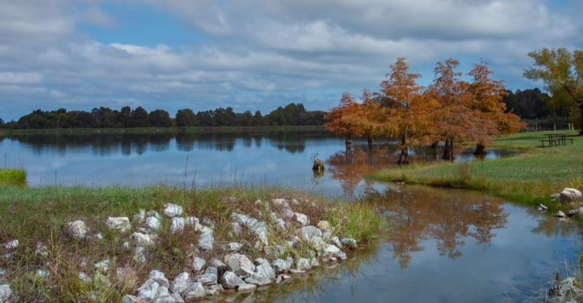
Mississippi River State Park

Not every great Arkansas backroad ends at a mountain overlook, and Mississippi River State Park is the proof.
Located at 2955 State Highway 44, Marianna, AR 72360, this park sits in the heart of the St. Francis National Forest in the Arkansas Delta, a landscape that feels entirely different from the Ozarks or the Ouachitas.
State Highway 44 leading into the park winds through flat bottomland forest where cypress trees rise from the water and Spanish moss drifts in the breeze, creating a moody, almost cinematic atmosphere.
The park borders both the Mississippi River and Bear Creek Lake, giving visitors access to two very different kinds of water in one visit.
I spent an afternoon here watching great blue herons work the shallows while a barge crept silently down the Mississippi in the background, and the contrast of stillness and slow movement was quietly hypnotic.
Fishing, birdwatching, and paddling are the main draws, but even a slow drive through the forest roads inside the park is enough to justify the trip.
The Delta region of Arkansas is often overlooked by travelers chasing the Ozarks, which means the roads here stay refreshingly empty even on weekends.
Fall migration brings an impressive variety of birds through the bottomland forest, making it a favorite stop for birders who know where to look.
Few places in the state offer this kind of flat, watery, deeply atmospheric scenery, and that rarity makes it all the more worth seeking out.
Queen Wilhelmina State Park

Highway 88 West out of Mena is the kind of road that earns its reputation before you even reach the destination at the end of it.
Queen Wilhelmina State Park is found at 3877 Highway 88 West, Mena, AR 71953, sitting atop Rich Mountain along the Talimena Scenic Drive, a 54-mile byway that crosses the Ouachita Mountains between Arkansas and Oklahoma.
The park itself is named for a Dutch queen, a quirky piece of history rooted in the late 1800s when Dutch investors helped fund a railroad through the mountains and hoped to attract European tourists.
The railroad never quite delivered on that vision, but the mountain views absolutely did, and the park that carries the queen’s name has been welcoming road trippers ever since.
I drove this route on a clear October afternoon when the ridge was lit up in orange and red, and the panoramic views from the summit pulled me out of my car at every overlook.
The Talimena Drive is widely considered one of the finest fall foliage routes in the South, and the section near Queen Wilhelmina delivers the most dramatic payoff.
The park has a lodge, a miniature train, and access to hiking trails that trace the ridgeline through the Ouachita National Forest.
Wildlife is active along the road, especially in the early morning, when deer and wild turkey are common sights near the tree line.
This drive rewards patience, a slow pace, and a willingness to stop every few miles just to look.
Crowley’s Ridge State Park

A narrow ridge of forested hills rising unexpectedly from the flat Delta landscape sounds like something out of a geography textbook, but Crowley’s Ridge is entirely real and entirely worth the detour.
Crowley’s Ridge State Park is located at 2092 Hwy. 168 North, Paragould, AR 72450, tucked into the rolling hills of northeastern Arkansas where the terrain surprises anyone expecting the usual flat Delta scenery.
The ridge itself is a geological oddity, a long elevated landform stretching through the otherwise level lowlands, covered in loess soil and hardwood forest that feels more Appalachian than Delta.
Hwy. 168 North approaching the park meanders through that wooded ridge terrain in a way that rewards a slow drive with windows down, especially in late spring when everything is deeply green and humming with bird activity.
I visited on a quiet Tuesday and had the lake almost entirely to myself, which made the afternoon feel like a private arrangement between me and the Arkansas countryside.
The park offers paddleboating, fishing, and a network of trails that wind through the hardwood forest and along the ridge slopes.
The Crowley’s Ridge National Scenic Byway connects several communities along the ridge and is rich with history, including Native American heritage sites and Civil War landmarks scattered along the route.
Fall color arrives here a little differently than in the mountains, softer and more golden, spread across the rolling canopy in a way that feels almost gentle.
Roads this quiet and scenery this underrated are a combination worth driving a long way to find.
Turner Bend Outfitter

Few spots on a backroad trip earn the title of perfect mid-drive stop the way Turner Bend does, sitting right where the Pig Trail Scenic Byway crosses the Mulberry River.
Turner Bend Outfitter is at 20034 N. Hwy 23, Ozark, AR 72949, a river outpost along Highway 23 that has been outfitting paddlers and road trippers for years in the heart of the Boston Mountains.
Highway 23, also called the Pig Trail Scenic Byway, is one of the most celebrated backroads in the state, a twisting corridor of pavement that tunnels through dense woodland and delivers constant scenery changes around every bend.
The stretch near Turner Bend is especially rewarding, where the road drops toward the river and the forest crowds in close on both sides, turning the drive into something almost theatrical.
I stopped here on a warm September afternoon, rented a canoe, and spent the next few hours floating the Mulberry River through a corridor of sycamore and river birch with no agenda and no cell service.
The river runs clear and cold over gravel bars, and the surrounding bluffs rise above the treeline in a way that makes you feel very small in the best possible sense.
Even if you skip the paddling, the pull-off at Turner Bend is a perfect spot to stretch your legs, watch the water, and eat something from a cooler.
A road trip that includes this bend in the river is one that earns a second trip before the first one is even finished.
Ozark Highlands Trail

The Ozone Trailhead does not advertise itself loudly, which is exactly the kind of energy I appreciate in a backroad destination.
The Ozark Highlands Trail at Ozone is accessed via Forest Service Rd 1456, Ozone, AR 72854, a remote entry point into one of the longest and most scenic trail systems in the mid-South.
The road leading out to this trailhead winds through the Ozark National Forest on narrow pavement that eventually gives way to gravel, and the drive itself feels like a slow transition from the everyday world into something older and quieter.
I followed Forest Service Rd 1456 on a cool morning in early November when the leaves were mostly down and the forest floor was a deep carpet of amber and rust.
The Ozark Highlands Trail stretches for over 200 miles through the Boston Mountains and surrounding terrain, and the Ozone Trailhead gives hikers access to some of its most remote and least-traveled sections.
The forest here is a mix of shortleaf pine and hardwood, with creek crossings, sandstone outcrops, and long ridgeline walks that reward anyone willing to put in the miles.
Even a short hike from the trailhead delivers a sense of solitude that is increasingly hard to find, with no road noise, no crowds, and no distractions beyond the trail itself.
The drive back out through the national forest at golden hour, with the low sun cutting through the pines, is the kind of payoff that stays with you for a long time.
Arkansas Grand Canyon

AR-7 through the Ozarks is already one of the most scenic roads in the state, but the stretch near Jasper takes that reputation and raises it considerably.
The Arkansas Grand Canyon viewpoint is along AR-7, Jasper, AR 72641, a pull-off that frames a sweeping drop into the Ozark Mountains and Big Creek Valley below, a view so dramatic that first-time visitors often just stand there quietly for a full minute before saying anything.
The valley is a broad Ozark mountain vista near the Buffalo National River region, and the depth and scale of the view become fully clear only when you are standing at the overlook looking out through layers of forested ridges.
AR-7 approaching Jasper from the south is a winding two-lane road that passes through Newton County, one of the least populated counties in Arkansas, where the roadside scenery shifts between open meadows, limestone outcrops, and dense cedar and hardwood forest.
I drove this road on a fall afternoon when the valley below was a mosaic of orange and yellow, and the low-angle light was turning the limestone bluffs a warm amber that no photograph quite captured correctly.
Jasper itself is a small town worth stopping in, with a historic courthouse square, local shops, and an easy-going atmosphere that fits the pace of the surrounding landscape.
The combination of the drive, the overlook, and the small-town stop makes this one of the most complete backroad experiences in the entire state.
Natural Dam Falls

Most waterfalls fall vertically, but Natural Dam plays by its own rules entirely, spreading wide across Mountain Fork Creek in a flat sandstone shelf that looks almost engineered.
Natural Dam Falls is located at 2137 Natural Dam Rd, Natural Dam, AR 72948, a small community tucked into the far western edge of Arkansas near the Oklahoma border, where the road itself is part of the experience.
The drive to Natural Dam follows a quiet two-lane route through the Ozark National Forest area, passing through forest and farmland with very little traffic and even less noise, the kind of road that makes you feel like you found something the GPS did not intend to share.
The natural dam is a broad rock shelf that spans Mountain Fork Creek near where it joins Lee Creek, creating a curtain of white water across its face.
I arrived on a weekday morning when the only other people there were a couple of local fishermen, and the sound of water moving across flat rock filled the whole clearing in a way that was deeply settling.
The surrounding forest is green and dense, and the creek above the dam is calm enough to wade in during low water, making it a popular spot for families looking for a cool afternoon escape.
The road back out retraces the same quiet route, but somehow it always feels a little different on the return, like the landscape has shifted just slightly while you were busy watching the water.