This Arizona Desert Route Connects Ghost Towns And Hidden Lakes In The Best Way
I used to think the only things waiting in the deep desert were sun-bleached rocks and a whole lot of empty space, but then I found this incredible route that feels like a hidden treasure map come to life.
It’s a little bit wild, slightly dramatic, and definitely not for the faint of heart if you’re worried about a few winding curves and steep drop-offs.
This specific slice of Arizona takes you through dusty, forgotten history and then suddenly hits you with some of the most stunning, sparkling water spots you’ll ever see in the middle of nowhere. It’s basically a gold-rush adventure without the actual hard labor or the itchy wool clothes.
It’s the ultimate Arizona weekend escape, just don’t forget to pack plenty of snacks! I drove this route on a clear October morning and came back with a camera full of photos, a head full of stories, and a serious craving to return.
If you love history, wild landscapes, and the thrill of a road that keeps surprising you around every bend, this is the drive for you.
Goldfield Ghost Town: Where The Gold Rush Still Echoes
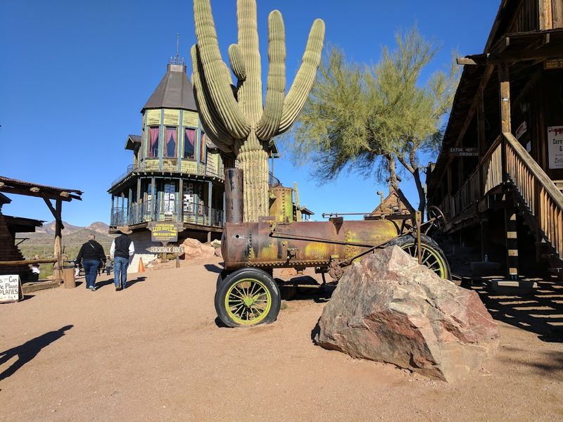
Back in the late 1800s, Goldfield was a roaring mining town packed with prospectors chasing their fortunes in the Arizona desert. Today, it has been carefully reconstructed just off the Apache Trail near Goldfield Road in Apache Junction, Arizona, and stepping into it feels like flipping back the pages of a history book.
The wooden storefronts, creaky boardwalks, and period-accurate details create an atmosphere that is surprisingly immersive.
On my visit, I took a guided mine tour that dropped us underground to see how miners actually worked in tight, dark tunnels. The narrow-gauge railroad ride gave a fun overview of the property, and the gunfight reenactments drew a big crowd of laughing families and wide-eyed kids.
There is also a zipline for those who want a little more adrenaline with their history.
Goldfield is the perfect warm-up stop before tackling the wilder sections of the trail. Arrive early on weekends to beat the tour groups and grab a spot near the front for the reenactments.
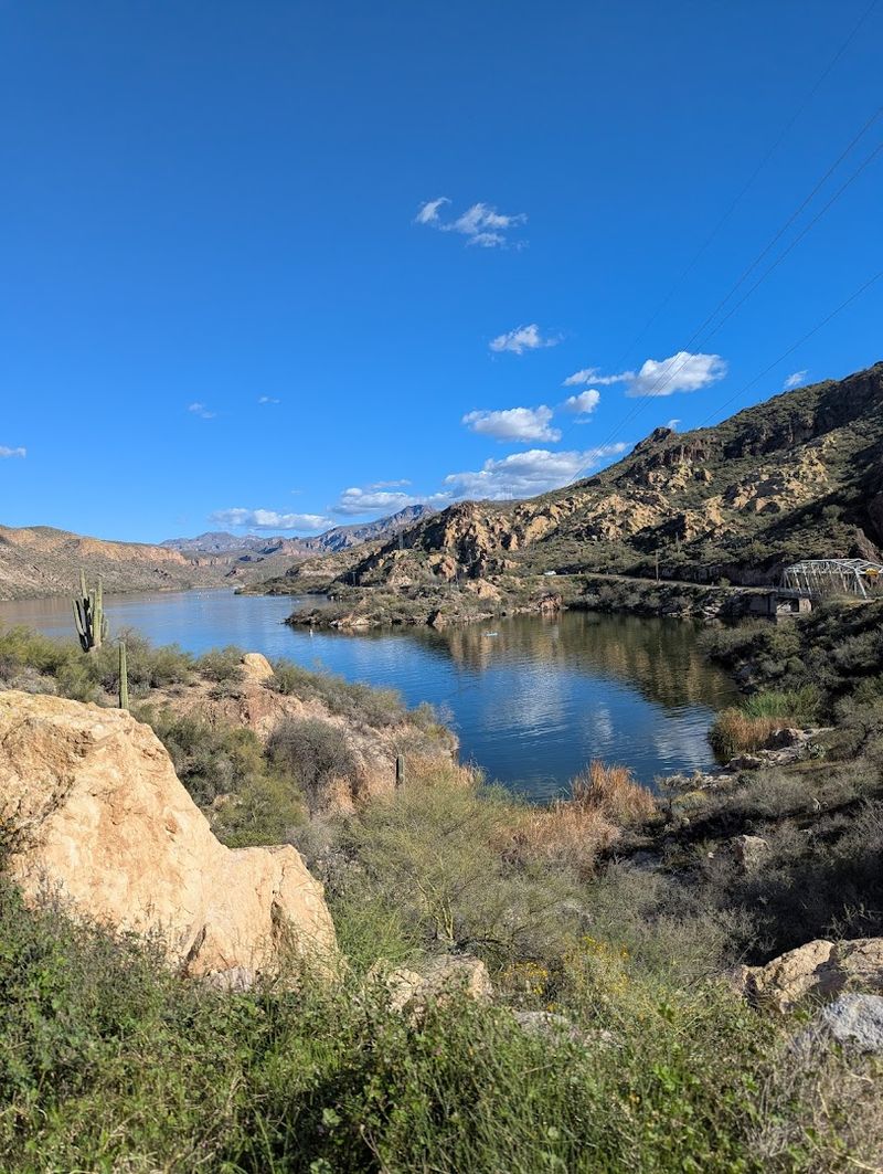
Canyon Lake: A Turquoise Surprise Tucked Into The Canyon Walls
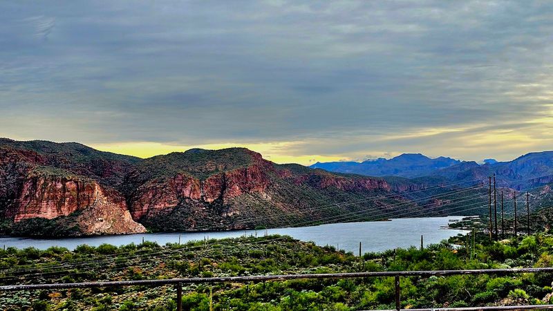
Honestly, nothing prepared me for the first look at Canyon Lake. Formed by the damming of the Salt River, this vivid turquoise reservoir sits cradled between dramatic canyon walls that rise sharply on every side, and the color contrast between the water and the rust-colored rock is jaw-dropping.
It is one of those views that makes you pull over, step out of the car, and just stand there quietly for a moment.
Boating and fishing are the big draws here, and the lake buzzes with activity on warm weekends. One of the highlights is boarding the Dolly Steamboat for a narrated tour of the canyon.
The guide shares fascinating details about the geology and history of the area, pointing out rock formations and wildlife along the water’s edge.
Picnic tables are scattered around the shoreline, making this a great spot to unpack lunch and soak up the scenery at your Apache Trail Scenic Drive adventure. Canyon Lake sits roughly 15 miles east of Apache Junction along State Route 88.
Tortilla Flat: The Tiniest Town With The Biggest Personality
With a permanent population of just six people, Tortilla Flat might be the smallest town in Arizona, but it punches way above its weight in character. Originally a stagecoach stop along the old freight route, this quirky little outpost still operates a general store, a small museum, and a restaurant that serves up hearty plates to hungry road-trippers passing through.
The most memorable feature inside is the walls, which are covered floor to ceiling with dollar bills. Travelers have been pinning their cash to the walls for decades, continuing a tradition that dates back to the stagecoach era when people left money behind as a kind of good-luck gesture.
It is wonderfully strange and absolutely worth seeing in person.
The prickly pear ice cream sold at the general store is a local favorite, and I can confirm it lives up to the hype. Tortilla Flat sits about 18 miles from Apache Junction and marks the last stop before the road turns to dirt.
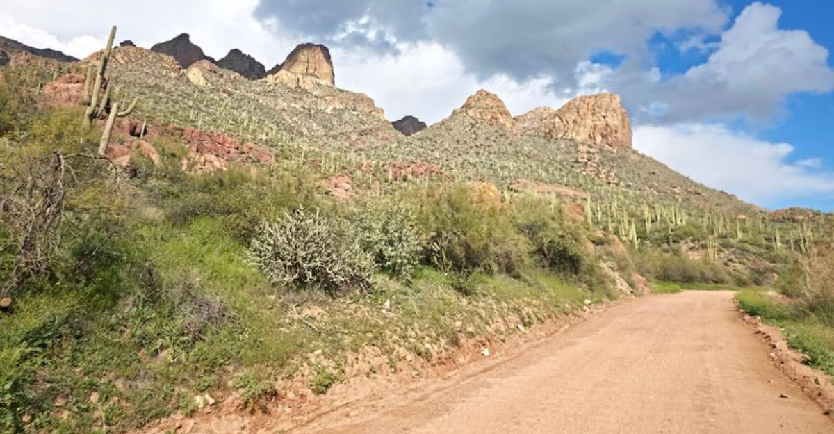
Fish Creek Hill: The Road That Tests Your Nerves And Rewards Your Eyes
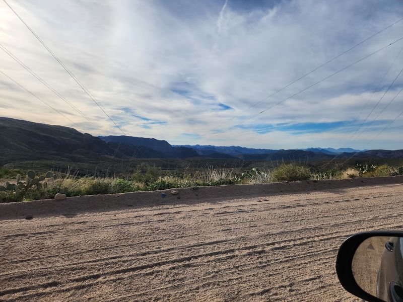
Right after Tortilla Flat, the pavement ends and the adventure truly begins. Fish Creek Hill is the section of the Apache Trail that gets people talking, and not always calmly.
The unpaved road narrows dramatically, hugs the edge of a canyon, and descends with steep hairpin curves that require slow, careful driving and a steady grip on the steering wheel. High-clearance vehicles are strongly recommended here.
But here is the thing: every white-knuckle moment is paid back with a view so raw and beautiful that it feels almost unfair. Looking out over the canyon from the switchbacks, you can see layers of ancient rock stretching far into the distance, with the glint of Apache Lake shimmering below.
The scale of it is humbling in the best possible way.
Take your time on this stretch, pull over at safe spots to take photos, and never rush the descent. The road demands respect, but it rewards patience with some of the most stunning desert scenery you will ever see.
Apache Lake: The Quiet One That Steals The Show
If Canyon Lake is the popular kid on the Apache Trail, then Apache Lake is the quiet one sitting in the corner who turns out to be the most interesting person in the room. Far fewer visitors make it this far along the trail, and that means you get to enjoy one of Arizona’s most beautiful lakes almost entirely to yourself.
The solitude here feels like a genuine reward for the effort it takes to reach it.
The road to Apache Lake is unpaved and rough, so a high-clearance vehicle is not just suggested, it is practically required. But once you arrive, the payoff is immediate.
The lake stretches out in a deep, vivid blue against the jagged red cliffs, and the silence is so complete that you can hear the water lapping against the shore.
Fishing, kayaking, and simply sitting on the bank watching the light change across the water are all worthy ways to spend time here. Apache Lake Marina offers basic amenities for those who want to stay overnight and catch a sunrise over the canyon walls.
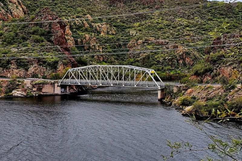
Roosevelt Dam And Bridge: A Monument To Engineering Ambition
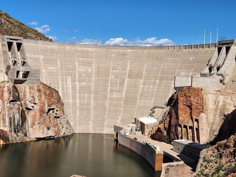
Completed in 1911, Roosevelt Dam was once the tallest masonry dam in the entire world, and standing at its base, you can absolutely feel the weight of that achievement.
Built by hand using blocks of quarried stone, it was a landmark project of the early 20th century and helped transform Arizona from a dry, unforgiving territory into a place where large communities could actually thrive by controlling the flow of the Salt River.
The Theodore Roosevelt Lake Bridge, added in 1989, arches gracefully over the water and offers panoramic views that are genuinely worth stopping for. Looking out from the bridge, you see the vast expanse of Theodore Roosevelt Lake on one side and the rugged Mazatzal Mountains on the other, a combination that reminds you just how dramatic this landscape really is.
Roosevelt Dam is located near the town of Roosevelt, Arizona, at the eastern end of the Apache Trail. It serves as the grand finale of the drive, and few road trips end on such a powerful, historically rich note.
Practical Tips For Driving The Apache Trail Like A Pro
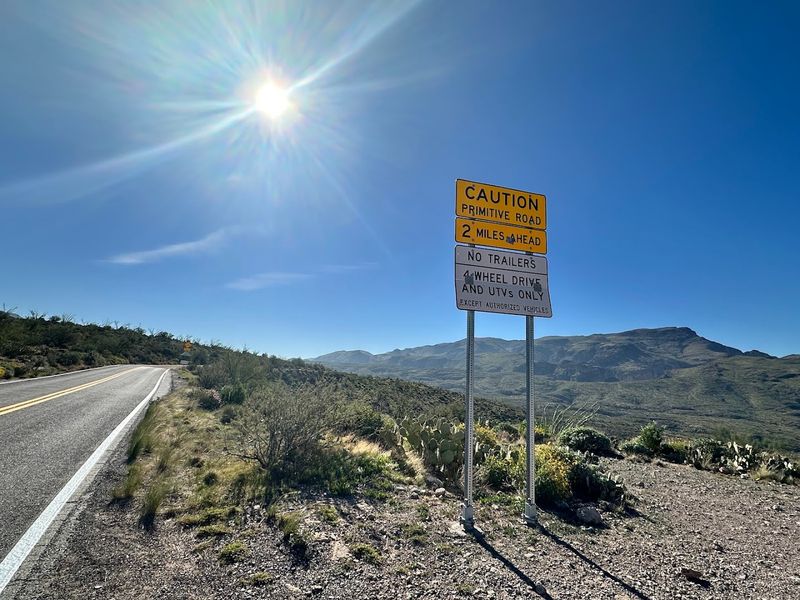
Before you load up the car and head out, a little planning goes a long way on the Apache Trail. The route mixes paved and unpaved sections, and the dirt road between Tortilla Flat and Roosevelt Dam is narrow, winding, and not suitable for RVs or vehicles towing trailers.
A high-clearance vehicle is the smart choice for the full experience, especially if you want to reach Apache Lake without any drama.
Cell service disappears quickly once you leave the paved sections, so download offline maps before you go and let someone know your route and expected return time. Carry more water than you think you need, especially in summer when temperatures regularly climb above 100 degrees Fahrenheit.
The Arizona heat is not something to underestimate.
The best times to visit are October through April, when temperatures are comfortable and the light is golden and gorgeous for photography. Always check road conditions through the Arizona Department of Transportation before departure, as sections can close after heavy rain or flooding.
Patience, preparation, and a full tank of gas are your three best travel companions on this route.