This Arizona Highway Turns 42 Miles Into One Of The Southwest’s Most Spectacular Drives
Arizona proves once again that the most unforgettable road trips are the ones that force you to trade GPS confidence for good old‑fashioned intuition.
I found myself perched on a cliffside overlooking turquoise water that seemed to have escaped from a painter’s palette, the road ahead a ribbon of lacquered asphalt daring me to keep moving. The sun threw shadows that danced across the pavement, turning each curve into a theatrical spotlight for the desert’s rugged cast of cacti, sagebrush, and the occasional startled road‑runner.
Somewhere between the scorching heat and the cool breeze whistling through the canyon walls, I realized I’d stumbled onto a highway that refuses to be merely traveled. It insists on being experienced, with a side of adrenaline and a dash of awe.
The History Behind The Road

Long before tourists discovered this route, Indigenous communities including the Salado, Apache, and Yavapai peoples walked these desert paths for migration and trade.
The trail was one of the most important corridors through this rugged landscape, connecting communities across what is now central Arizona.
Between 1903 and 1905, the U.S. government transformed this ancient footpath into a wagon road, primarily to haul construction materials for the Theodore Roosevelt Dam.
Many Apache individuals provided the labor that made this road possible, which is a significant piece of history that often gets overlooked. After the dam was completed, the Southern Pacific Railroad saw tourism potential and began marketing the route, officially coining the name “Apache Trail.”
On February 25, 1987, it was dedicated as Arizona’s first historic highway. Knowing this backstory makes every mile feel richer and more meaningful as you roll through the desert landscape.
Lost Dutchman State Park

Right at the starting point near Apache Junction, Lost Dutchman State Park sets the tone for the entire drive. The park sits at the base of the Superstition Mountains, and those rocky peaks are genuinely jaw-dropping up close.
Jagged ridgelines jut into the sky in ways that make you feel small in the best possible way. The park is named after the legendary Lost Dutchman Mine, a tale about a hidden gold deposit supposedly discovered by a German immigrant named Jacob Waltz in the 1800s.
Treasure hunters have been searching these mountains ever since, and the mystery has never been solved.
Hiking trails here range from easy walks to more challenging climbs, and the wildflower blooms in spring are truly something special. The Siphon Draw Trail is a popular choice for those wanting a closer look at the mountain terrain.
Even if you only stop for 30 minutes, this park earns its place as a worthy first chapter of the Apache Trail adventure.
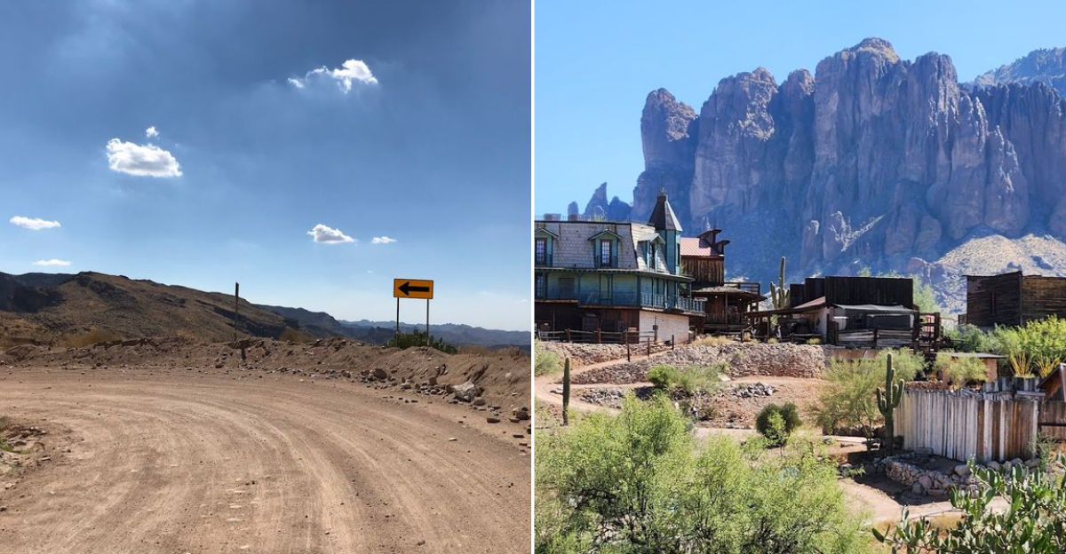
Goldfield Ghost Town

Just a short distance from Lost Dutchman State Park, Goldfield Ghost Town is a recreation of an 1890s mining settlement that once boomed thanks to a nearby gold strike.
The original town was abandoned around 1926, but it has been brought back to life as one of the most entertaining stops on the entire route.
Visitors can try gold panning, watch staged gunfight performances, browse shops selling local crafts and souvenirs, and even take a narrated mine tour underground.
The whole place has a playful, theatrical energy that families with kids absolutely love. It feels like stepping into a Western movie set, except everything around you is genuinely old.
The backdrop of the Superstition Mountains framing the wooden storefronts makes for some of the most photogenic shots of the trip. Even if history is not your thing, the sheer novelty of Goldfield makes it hard to skip. Plan to spend at least an hour here before hitting the road again.
Canyon Lake And The Dolly Steamboat

About 15 miles into the drive, Canyon Lake appears suddenly around a bend, and the contrast of deep blue water against rust-colored canyon walls is genuinely stunning.
This reservoir sits inside a narrow canyon carved by the Salt River, giving it a dramatic, enclosed feeling that larger lakes simply do not have.
The star attraction here is the Dolly Steamboat, a narrated sightseeing cruise that glides through the canyon and offers a completely different perspective on the landscape. The cruise typically lasts about 90 minutes and is especially popular with visitors who want to experience the scenery without hiking.
Wildlife sightings including bald eagles, great blue herons, and mule deer are common along the shoreline.
Boat rentals are also available for those who prefer to explore on their own schedule. The campground and picnic areas near the marina make Canyon Lake a great spot for a midday break. Arriving early on weekends is a smart move since parking fills up quickly during peak season.
Tortilla Flat – The Tiniest Town On The Trail

With a permanent population of just six people, Tortilla Flat is one of the most delightfully quirky stops in all of Arizona. This former stagecoach stop sits about 18 miles from Apache Junction and has been welcoming road-trippers for generations.
Walking into the restaurant feels like entering a time capsule with dollar bills stapled to nearly every surface of the walls and ceiling, a tradition started by travelers decades ago.
The menu leans heavily into Southwest comfort food, and the prickly pear ice cream has developed a loyal following among repeat visitors. There is also a small mercantile shop where you can pick up locally made goods and trail souvenirs.
The whole town takes about 20 minutes to explore, but its personality is outsized compared to its footprint.
Tortilla Flat also marks roughly the point where the pavement ends and the unpaved road begins. Fueling up here, both literally with food and mentally with a good attitude, before tackling the rougher terrain ahead is genuinely solid advice.
Fish Creek Vista And The Dirt Road Section

Past Tortilla Flat, the Apache Trail transforms into something that feels genuinely untamed.
The paved road gives way to a narrow, winding dirt track that hugs the edges of canyon walls, and Fish Creek Vista is where that shift becomes most dramatic. Looking down into Fish Creek Canyon from here is one of those views that makes you grip the steering wheel a little tighter.
The section from Fish Creek Vista at milepost 222 to Fish Creek Bridge at milepost 223.5 is currently restricted to high-clearance four-wheel-drive vehicles and UTVs, following damage from the 2019 Woodbury Fire and subsequent flooding.
Trailers are not permitted, and large RVs should avoid this stretch entirely. Checking current conditions on AZ511.gov before heading out is strongly recommended.
For those with the right vehicle, the reward is a raw, cinematic stretch of road that feels nothing like a typical highway. The scenery here is rugged and unfiltered, and the sense of isolation is both thrilling and deeply peaceful at the same time.
Theodore Roosevelt Dam And Roosevelt Lake

The road ends at one of the most historically significant structures in the American West. When Theodore Roosevelt Dam was completed in 1911, it created the largest artificial reservoir in the world at that time, a remarkable engineering achievement built in a remote desert canyon with limited technology.
President Theodore Roosevelt himself attended the dedication ceremony and reportedly called the view one of the most spectacular he had ever seen.
Roosevelt Lake stretches across more than 17,000 acres when full and remains a popular destination for boating, fishing, and camping today.
The dam itself underwent major reconstruction between 1989 and 1996, raising its height to increase water storage capacity, but it retains its original historic character and visual presence.
Just a short drive from the dam, Tonto National Monument preserves remarkable Salado cliff dwellings that date back to the 13th century, offering one final layer of history before the journey concludes.
Finishing the Apache Trail here, surrounded by water, canyon, and centuries of human story, feels like a genuinely satisfying ending.
Tonto National Monument

Few stops along the Apache Trail carry the quiet power of Tonto National Monument, where 700-year-old cliff dwellings cling to the rocky hillside above Roosevelt Lake. Built by the Salado people, these stone rooms tell a story of remarkable ingenuity and survival in an unforgiving desert landscape.
The lower dwelling is accessible via a half-mile uphill trail, rewarding visitors with sweeping views of the shimmering blue lake below. Rangers lead guided tours to the larger upper cliff dwelling, offering deeper insight into Salado daily life.
It feels like stepping back in time, with the desert stretching endlessly in every direction. The setting alone makes the stop feel unforgettable, with stone, water, and desert sky all competing for attention.
Every step up the trail adds more perspective, both on the landscape and the people who once lived within it. The walls may be silent now, but the craftsmanship still speaks clearly.
Roosevelt Lake below adds a surprising flash of blue to all that rugged desert color. It is one of those places where the scenery is impressive, but the history is what truly stays with you.