This Breathtaking 338-Mile Drive Might Be The Most Overlooked Experience In Florida
Most people picture Florida as theme parks and crowded beaches, and then a drive like this changes that completely.
You leave Miami thinking it’s just another stretch of highway. Then the land starts to disappear.
Water on both sides, bridges ahead, and a road that doesn’t feel like it belongs here at all.
A drive like this across Florida isn’t something most people expect, and that’s exactly why it stands out the moment it begins.
Mile after mile, it keeps unfolding. Islands linking together, open ocean stretching out, views that don’t repeat themselves.
You don’t rush it. You slow down, stop when it feels right, and let the experience build on its own.
It’s not just about getting to Key West.
It’s everything along the way that makes it worth it.
If you have never heard of it, that is exactly why you need to keep reading.
The Road That Replaced A Railroad
Before there was a highway, there was a railroad. Henry Flagler, the man who helped build Standard Oil, decided in the early 1900s that he wanted to connect Key West to the Florida mainland by rail.
People called it “Flagler’s Folly” because the idea sounded completely impossible at the time.
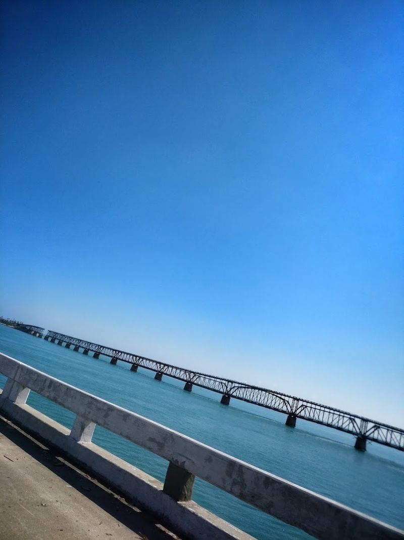
His Florida East Coast Railway opened in 1912, stretching across open ocean on a series of bridges and causeways. It was an engineering miracle that shocked the entire country.
A powerful hurricane in 1935 destroyed large sections of the track, and the railroad was never rebuilt. Instead, engineers converted the old railroad bridges and right-of-way into what became the Overseas Highway.
The road officially opened in 1938, turning a private railway into a public road that anyone in Florida could drive for free.
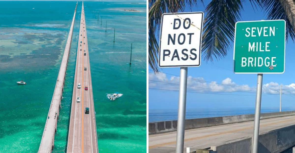
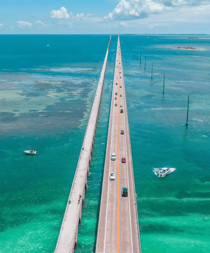
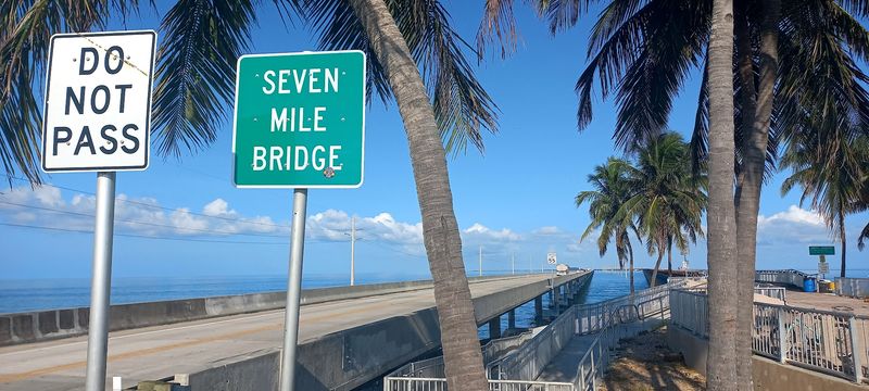
42 Bridges Holding It All Together
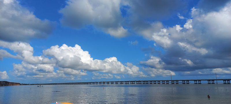
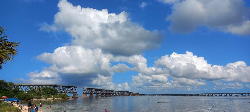
Driving the Overseas Highway means crossing 42 bridges, which is not something most road trips can claim. Some of these bridges are short hops between islands, but others feel like you are flying low over the ocean.
The most famous of them all is the Seven Mile Bridge, which spans 6.79 miles between Knight’s Key and Little Duck Key. Standing on it, you can see the Atlantic Ocean on one side and Florida Bay on the other, both glittering in shades of green and blue that look almost painted on.
An older version of the Seven Mile Bridge still stands beside the new one and has been converted into the world’s longest fishing pier. Florida really does know how to recycle its infrastructure in the most scenic way possible.
Crossing these bridges gives the whole drive a floating, dreamlike quality that stays with you long after you are home.
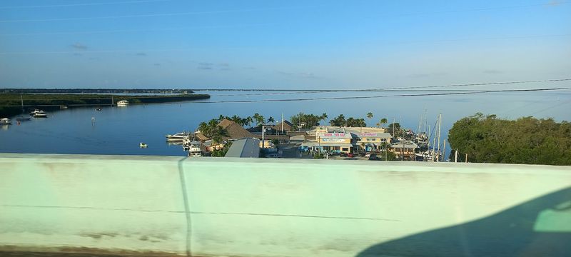
The Florida Keys Are Not One Island
A lot of people assume the Florida Keys is one big island, but the highway actually threads through a chain of more than 1,700 islands. The Overseas Highway connects about 45 of them, each one with its own character, name, and personality.
Key Largo is the largest and sits closest to the mainland, known for its coral reef diving and laid-back atmosphere. Islamorada calls itself the “Sport Fishing Capital of the World” and takes that title seriously.
Marathon sits roughly in the middle of the Keys and serves as a practical hub for travelers.
Big Pine Key is home to the tiny Key deer, an endangered species found nowhere else on Earth. Then comes the Lower Keys, quieter and less visited, before the highway finally delivers you to Key West at the very end.
Each island along this Florida road feels like a small world of its own.
Mile Markers That Tell You Exactly Where You Are
One of the quirkiest features of the Overseas Highway is its mile marker system, and locals rely on it more than street addresses. Mile Marker 0 sits in Key West, and Mile Marker 126 is near Florida City on the mainland, where the Keys officially begin.
Businesses, restaurants, and attractions all give their location by mile marker rather than a traditional address. You might hear someone say “meet me at MM 81.5 oceanside” and that tells a Keys local exactly where to go.
The markers count down as you drive south toward Key West, which gives the whole journey a satisfying sense of progress. Each small green sign feels like a countdown to something great.
Visitors who catch on to this system quickly feel like insiders, while those who ignore it spend a lot of time confused and circling back. It is a small detail that adds a lot of charm to the drive.
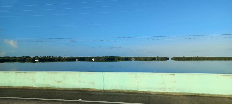
Water On Both Sides, Almost The Entire Time
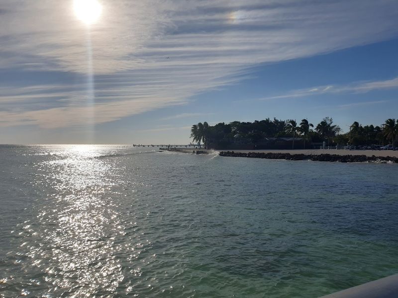
There are not many roads in the world where you can look left and see one ocean, then look right and see another. On the Overseas Highway, that is simply Tuesday.
The highway runs between the Atlantic Ocean on the southeast side and Florida Bay and the Gulf of Mexico on the northwest side.
The colors of the water change constantly depending on the time of day, the weather, and the depth below the surface. Shallow areas glow bright turquoise, while deeper channels shift to a rich cobalt blue.
At sunrise and sunset, the whole scene turns shades of pink and gold that make even the most seasoned traveler stop and stare.
On clear days, you can see so far across the water that the horizon seems to go on forever. This visual experience alone is worth the drive, and no photograph fully captures what it feels like to be surrounded by it in real life.
The Wildlife That Shares The Road With You
The Overseas Highway passes through some of the most ecologically unique territory in North America, and the wildlife reflects that. Key deer, which stand only about 24 to 28 inches tall at the shoulder, roam freely on Big Pine Key and No Name Key.
They are so small they look like deer that someone accidentally left in the dryer.
Manatees are frequently spotted in the shallow waters near bridges and marinas along the route. Brown pelicans, roseate spoonbills, and ospreys are common sights overhead, especially near the water.
The Florida Keys National Marine Sanctuary protects the surrounding ocean, making this one of the healthiest marine ecosystems in Florida.
American crocodiles, which are rarer and more reclusive than alligators, also live in the brackish waters around the Keys. Keeping your eyes open while driving this highway means you are also on a wildlife safari without even trying.
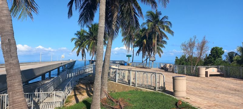
Bahia Honda State Park: The Surprise In The Middle
Around Mile Marker 37, one of the most beautiful state parks in all of Florida appears almost without warning. Bahia Honda State Park sits on a 524-acre island and consistently ranks among the top beaches in the entire United States, which is a bold claim that the park backs up effortlessly.
The beach here has fine, white sand and calm, clear water in colors that look more Caribbean than continental American. Snorkeling just offshore reveals sea fans, tropical fish, and the occasional sea turtle cruising past.
The ruins of Flagler’s old railroad bridge loom dramatically over one end of the park, adding a layer of history to the natural beauty. Camping is available here, which means some lucky travelers get to fall asleep to the sound of the ocean right on the Overseas Highway.
Stopping here is not optional; it is something you will regret skipping for years.
The Best Time To Make The Drive
Florida weather plays a big role in how enjoyable this drive can be, and timing it right makes a noticeable difference. The dry season, which runs from November through April, offers the most comfortable temperatures, lower humidity, and clearer skies.
This is also the most popular time, so expect more traffic on the highway and higher prices at accommodations.
Summer brings heat, humidity, and the possibility of afternoon thunderstorms, but the Keys are often less crowded and prices drop significantly. The light during summer mornings is also spectacular for photography along the water.
Hurricane season runs from June through November, so checking forecasts during those months is smart planning. Weekday drives are noticeably calmer than weekend ones, especially near Key Largo and Islamorada.
Arriving at the Seven Mile Bridge right around sunrise is one of those Florida experiences that belongs on every bucket list, regardless of what season you choose to go.
John Pennekamp Coral Reef State Park At Mile Marker 102
Just after entering the Florida Keys from the mainland, John Pennekamp Coral Reef State Park sits at Mile Marker 102.5 in Key Largo and deserves its own paragraph in any honest conversation about the Overseas Highway. It was the first underwater state park in the United States, established in 1963, and it protects about 70 nautical square miles of coral reef.
Glass-bottom boat tours let non-swimmers see the reef without getting wet, while snorkelers and scuba divers can explore the living coral formations up close. The Christ of the Abyss statue, a nine-foot bronze figure submerged in about 25 feet of water, is one of the most photographed underwater landmarks in Florida.
Even a short stop here at the beginning of the drive sets the tone for everything that follows. The park is a reminder that the real magic of the Overseas Highway is not just the road itself but everything surrounding it.
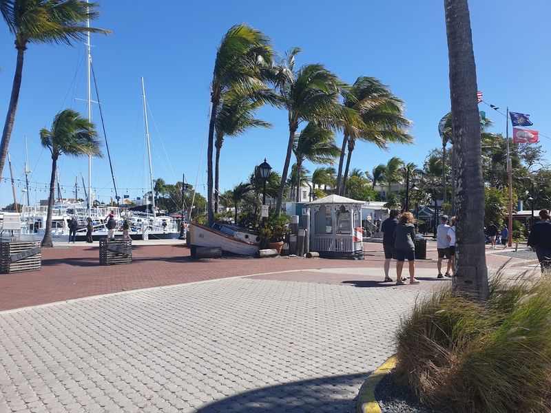
Key West: The End Of The Road And The Beginning Of Something Else
The Overseas Highway ends in Key West, a city that has its own rules, its own rhythm, and its own very specific energy. At Mile Marker 0, the road officially concludes, and a colorful buoy near the southern tip of the island marks the southernmost point in the continental United States.
Key West sits just 90 miles from Cuba, and that geographic fact shapes everything about the place, from the food to the architecture to the way people move through their day. The historic Old Town area is filled with wooden Conch-style houses, tropical gardens, and streets wide enough for a golf cart but not much else.
Mallory Square hosts a nightly sunset celebration where street performers, artists, and crowds gather to applaud the sun as it drops into the Gulf of Mexico. Ending a drive along the Overseas Highway here feels less like finishing a road trip and more like arriving somewhere you did not know you had been looking for.