This Breckenridge Trail Leads To A Secret Waterfall That Feels Like A Fairy Tale
Some hikes make you work, but this one knows exactly how to reward every step. The trail begins with that crisp mountain energy that wakes you up fast, then keeps raising the stakes with forested turns, rocky drama, rushing water, and scenery that feels almost too perfectly arranged.
Colorado delivers plenty of postcard views, but this route has a full adventure arc, from quiet alpine beauty to weathered mining history and a waterfall that steals the whole scene. It is rugged enough to feel exciting, but approachable enough that you do not need expert-level gear or nerves of steel to enjoy it.
Every bend gives you another reason to slow down, look around, and take one more photo before moving on. By the time the falls come into view, the climb feels completely worth it.
In Colorado’s high country, this is the kind of hike that turns a regular day outdoors into a story you will keep retelling.
Where The Adventure Officially Begins

Not every adventure announces itself with fanfare. Some start quietly on a dirt road that makes your car suspension question your life choices.
The trailhead for this spot sits along Spruce Creek Road at 1160 Spruce Creek Road, Breckenridge, Colorado 80424, and reaching the upper parking area is smoother in a high-clearance vehicle or SUV, though visitors in standard cars have made it work too.
The road is unpaved but manageable, and parking closer to the upper lot shaves roughly a mile off your hike in each direction. That matters more than it sounds at 10,000-plus feet of elevation.
Early Sunday mornings are noticeably quieter here. By midday, the lot fills up fast and the trail gets social in a way that is charming at first and slightly less charming when you are trying to catch your breath on a steep section.
Arriving before 9 a.m. puts you ahead of the crowd and rewards you with that rare mountain stillness that no amount of planning can fully replicate.
Pro Tip: Check trail conditions before heading out. Snow can linger on upper sections well into early summer, making the route genuinely difficult without proper gear.
A Honest Look At What You Are Signing Up For

Let’s be straightforward about something: this hike is not a casual afternoon stroll. The route from the lower trailhead involves roughly 1,500 feet of elevation gain and tops out near 11,850 feet above sea level.
That combination will humble even reasonably fit hikers who are not acclimatized to Colorado altitude.
Visitors coming from lower elevations, say sea level or the flatlands of the Midwest, often find the thin air more surprising than the terrain itself. Legs feel heavier, breathing feels shallower, and the trail somehow seems steeper than the map suggested.
Taking it slow and drinking plenty of water makes a measurable difference.
The trail is rated easy to moderate by some sources, but hikers consistently note that the upper sections involve real rock scrambling and loose footing. Trekking poles are genuinely useful here, especially on the descent when tired legs and rocky ground become an unpredictable combination.
Best For: Hikers with some trail experience who are comfortable with uneven terrain and do not mind a workout that earns its reward. Families with young children have completed it, but plan for a slower pace and extra snack breaks.
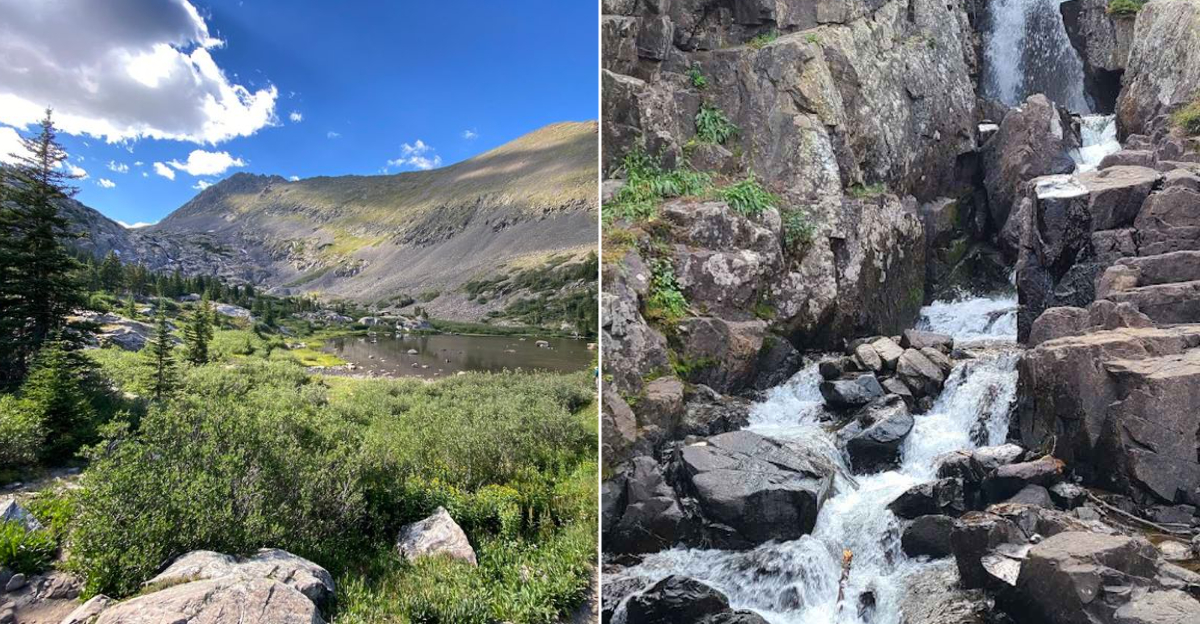
What Actually Waits At The End Of The Climb

Continental Falls has a pleasing symmetry to it that photographs do not fully capture. The water drops over layered rock formations in a clean, confident cascade, and the surrounding cliff walls frame it in a way that feels almost theatrical.
Standing at the base, the sound alone is worth the effort of getting there.
The falls are visible from a distance as you approach, which is a small but satisfying detail. You do not suddenly stumble upon them; instead, you catch glimpses through the trees that build anticipation in the best possible way.
At full flow during late spring and early summer snowmelt, the volume of water is genuinely impressive.
Visitors often spend time sitting on the rocks nearby, eating lunch, and simply existing in a place that has no cell service and no notifications. That last part is either a dealbreaker or a selling point depending entirely on who you are.
Quick Verdict: Continental Falls delivers a visually striking payoff that justifies the climb. The rock formations surrounding the cascade give it a structured, almost architectural quality that sets it apart from many Colorado waterfalls.
A Bonus Nobody Talks About Enough

About 200 yards before you reach the main falls, two cabins from the gold mining era appear beside the trail. One of them is remarkably well preserved, with walls and a roof that have somehow survived Colorado winters for well over a century.
It is the kind of discovery that stops you mid-stride.
These cabins add a layer of history to what is already a visually rich hike. Breckenridge has deep roots in Colorado mining history, and stumbling across physical remnants of that era in the middle of a mountain trail gives the walk a storytelling quality that guidebooks rarely do justice.
The cabin near the falls also serves as a useful navigation landmark. Visitors have noted that trail markers are sparse in places, and the cabin is a reliable visual cue.
Look to your left past the cabin for a dual pine tree with an arrow marking the path toward Lower Mohawk Lake if you plan to continue further up.
Insider Tip: Pause at the intact cabin before pushing on to the falls. The structure is genuinely worth a few minutes of your time, and it makes the hike feel like something more than just a destination sprint.
Because The Markers Are Not Going To Hold Your Hand

Here is where a little preparation goes a long way. The Spruce Creek Trail area has multiple intersecting routes, two trailheads on opposite sides of the valley, and trail markers that range from helpful to completely absent depending on which section you are on.
Downloading an offline map before you leave cell range is not optional; it is genuinely necessary.
Cell coverage in the valley is spotty at best. There are no services at the trailhead, no ranger station nearby, and no friendly signage that will confidently point you toward the falls every step of the way.
Visitors who arrive without a downloaded map or a physical printout occasionally end up on a different trail entirely.
The blue diamond markers on trees help in winter and early spring when snow covers the ground. During summer, the path is more visible but junctions can still be confusing, particularly where the trail splits toward Mohawk Lakes or continues toward the upper falls.
Planning Advice: Review the route map the night before your hike. Know the key landmarks: the first trailhead sign, the cabin near the falls, and the dual pine tree arrow marker.
That mental prep pays off when you are standing at a junction catching your breath.
When The Falls Are Just The Beginning

Continental Falls sits roughly at the midpoint of a much longer journey. Continue past the waterfall and the trail climbs toward Lower and Upper Mohawk Lake, topping out at around 12,177 feet in the shadow of Quandary Peak.
The views from up there are the kind that make you briefly forget how tired your legs are.
Upper Mohawk Lake sits in a bowl of rock and sky that feels genuinely remote. Ice fields can persist across sections of that upper trail well into July, so timing and gear matter considerably if you plan to push that high.
Visitors have spotted people fly fishing at Lower Mohawk Lake, and the surrounding alpine terrain rewards anyone willing to linger.
The full loop including Spruce Creek Trail and upper Continental Falls can stretch to around seven miles or more depending on your starting point. That is a full day commitment, not a quick detour, so plan your food, water, and turnaround time with honesty about your fitness level and the afternoon mountain weather patterns Colorado is famous for.
Who This Is For: Experienced hikers looking for a full alpine day with multiple payoffs. Who this is not for: anyone counting on finishing before lunch without breaking a sweat.
Timing, Gear, And The One Thing Worth Knowing

Continental Falls earns its reputation as a genuinely rewarding destination, but the visitors who enjoy it most are the ones who showed up prepared. Arriving early, ideally before 9 a.m. on weekends, makes a noticeable difference in both parking availability and trail atmosphere.
By early afternoon the trail gets busy, and the road back toward Breckenridge can back up significantly due to construction traffic on I-70.
Pack more water than you think you need. The elevation and exertion combine in ways that catch people off guard, especially families with kids who set a slower pace and spend more total time on the trail.
Snacks, sunscreen, and layers are standard Colorado hiking logic that applies fully here.
The falls are roughly 15 to 20 minutes from downtown Breckenridge by car, which makes this a genuinely accessible half-day outing. Pair it with a post-hike stroll through Breckenridge’s compact Main Street and you have a satisfying day that required almost no complicated logistics to pull off.
Common Mistakes to Avoid: Skipping the offline map download, underestimating the altitude effect, and arriving after 10 a.m. on a summer weekend. Fix those three things and this hike becomes exactly the fairy-tale experience everyone says it is.