This Colorado Overlook Offers Jaw-Dropping Views Of 14 Mountains At Once
Somewhere high in the Rockies, the road climbs, the sky stretches wider, and suddenly the view feels almost too big to fit through the windshield. One moment you are just driving, and the next you are staring across a vast mountain basin, distant ridgelines, rolling open country, and peaks that seem to stack themselves into the horizon like nature showing off.
Colorado has a way of turning an ordinary roadside stop into a full-on jaw-drop moment, and this overlook delivers that feeling fast. On a clear day, you can spot a sweep of named mountains, trace the curves of the land below, and watch clouds throw moving shadows across the high country.
Bring a camera, but do not rush the moment. Let the kids point, guess, and gasp a little.
This is Colorado’s big-sky drama at its best, the kind of stop that makes the drive unforgettable.
The Panoramic Overlook With A Mountain ID Map

There is a moment at this overlook when your brain simply cannot process what your eyes are seeing. A mounted map at the lookout deck identifies each peak by name, turning a spectacular blur of ridgelines into a geography lesson you actually want to take.
The view stretches across the South Park basin to the west, where the Collegiate Range dominates the horizon. On the clearest days, visitors can identify up to 14 distinct named mountains from a single vantage point, which is genuinely rare for a roadside stop that requires zero hiking to reach.
Families with kids find the labeled map especially useful because children can play a kind of mountain matching game, pointing and confirming each summit. Couples tend to linger here longer than anywhere else on the property.
Even solo travelers who stop just to stretch their legs often end up standing at the railing for a solid fifteen minutes, quietly recalibrating their sense of scale.
Pro Tip: Morning visits on weekdays offer the clearest sightlines and the smallest crowds, giving you the overlook almost entirely to yourself.
Mount Lincoln And The Mosquito Range On The Horizon

Mount Lincoln stands at 14,286 feet, making it one of Colorado’s most accessible fourteeners, and from the Wilkerson Pass overlook you can spot it anchoring the northern portion of the Mosquito Range. Seeing a fourteener from a highway pullout, without breaking a sweat, feels like finding money in an old jacket pocket.
The Mosquito Range runs roughly north to south and forms a dramatic wall along the western edge of South Park. On a clear afternoon, the snow that clings to Lincoln’s upper flanks well into early summer catches the light in a way that makes the whole ridge glow.
It is the kind of view that makes you want to call someone and describe it badly over the phone.
For families traveling with younger kids, pointing out Lincoln by name gives the scenery a concrete anchor. Geography suddenly feels real and exciting rather than abstract.
The mountain identification sign at the overlook deck marks Lincoln clearly, so even first-time visitors can locate it within seconds.
Best For: Fourteener enthusiasts who want a preview glimpse of Lincoln before planning a future summit attempt via Kite Lake.
Mount Bross And Its Broad, Rolling Summit

Mount Bross sits right next to Lincoln at 14,172 feet, and its wide, rounded summit profile makes it one of the easier peaks to pick out from the Wilkerson Pass overlook even without a map. There is something almost friendly about its silhouette compared to the sharper, more jagged neighbors crowding the skyline.
Bross and Lincoln are so close together that they are frequently climbed on the same outing, which is a fun piece of trivia to share with anyone standing next to you at the railing. The mountain identification sign at the visitor center deck helps visitors distinguish the two peaks, which look deceptively similar from this distance.
For couples making a spontaneous stop along Highway 24, Bross is usually the second peak they successfully identify after Lincoln, and there is a small but genuine sense of accomplishment in that. Kids tend to find the broad summit profile easier to trace against the sky than the sharper technical peaks further south.
Why It Matters: Recognizing Bross by shape from this overlook is a great starter skill for anyone new to Colorado peak identification and Rocky Mountain geography.
Mount Democrat Anchoring The Southern Mosquito Range

Mount Democrat, at 14,148 feet, rounds out the famous PaBLo fourteener group alongside Lincoln, Bross, and Cameron, and its slightly more pyramid-like shape makes it a standout in the Mosquito Range lineup. From the Wilkerson Pass overlook, it anchors the southern end of that cluster with quiet authority.
The name alone tends to spark conversations at the railing, especially when mixed groups of strangers are all squinting at the same ridgeline trying to sort out which summit is which. The mountain map at the deck settles the debate quickly and diplomatically.
It is one of those small, satisfying moments that roadside overlooks do better than almost anywhere else.
Hikers who have summited Democrat often get a kick out of spotting it from this angle, since the perspective from the highway is completely different from the view at the trailhead. Seeing a mountain you have climbed from thirty miles away gives the whole landscape a personal dimension that no guidebook can fully replicate.
Insider Tip: Democrat is typically the last of the PaBLo group to shed its snow each spring, so its white cap remains visible from the overlook well into June most years.
Pikes Peak Dominating The Eastern Skyline

Turn around from the western panorama at Wilkerson Pass and Pikes Peak fills the eastern horizon with the kind of presence that makes other mountains feel like they are still practicing. At 14,115 feet, it is one of the most recognized summits in North America, and from this overlook the full sweep of its western face is on full display.
What makes this particular view of Pikes unusual is the distance and angle. Most people see Pikes from Colorado Springs to the east, where it rises sharply above the city.
From Wilkerson Pass, the mountain sits across a broad open corridor, giving it a more isolated, almost solitary quality that feels entirely different from the urban-backdrop version most visitors know.
Families who have driven up Pikes Peak on a previous trip often get a genuine thrill recognizing the summit from this new angle, connecting two separate memories into one expanded picture of Colorado. The visitor center staff are happy to point it out and explain the geography if the identification sign leaves any doubt.
Quick Verdict: The eastern view toward Pikes Peak alone justifies pulling off the highway, even if you only have five minutes to spare.
The South Park Basin Spread Below

South Park is not a theme park, despite what the television show has done to the name, and standing at the Wilkerson Pass overlook looking west makes that abundantly clear. The basin stretches out below in every shade of golden and sage green, one of the largest high-altitude mountain parks in North America, sitting at roughly 9,000 feet above sea level.
The scale of it is genuinely hard to absorb. The valley floor is so wide and the surrounding ranges so distant that the whole scene feels more like a landscape painting than something you drove to on a Tuesday afternoon.
Visitors frequently describe a slight disorientation, a pleasant one, as their eyes try to find an edge that keeps retreating further into the distance.
For anyone traveling west toward Buena Vista or Fairplay, this overlook serves as a natural preview of the terrain ahead. The basin view also helps explain why South Park has such dramatic weather patterns, since the open valley acts as a kind of atmospheric stage where storms build and move with impressive speed.
Planning Advice: Check the western sky before descending into South Park. Afternoon thunderstorms build quickly over the basin in summer, and the overlook gives you a perfect early warning vantage point.
The Sawatch Range Floating On The Far Western Edge

On the clearest days, the Sawatch Range materializes along the far western horizon like a rumor that turns out to be true. This is Colorado’s highest mountain range, home to more fourteeners than any other range in the state, and from Wilkerson Pass you can catch its outline hovering above the South Park basin in a way that feels almost cinematic.
The Collegiate Peaks, which include mounts Harvard, Yale, Columbia, and Oxford, are part of the Sawatch and are identifiable from the overlook deck using the mountain map provided on site. Seeing peaks named after Ivy League schools while standing in a parking lot off a federal highway is exactly the kind of only-in-Colorado moment that makes road trips worth taking.
Distance softens the Sawatch into something almost dreamlike from this vantage point. The peaks appear lighter in color than the closer ranges, their snowfields fading to pale blue-white against the sky.
It is the kind of view that makes you feel like you are standing at the edge of something much larger than your current itinerary.
Best For: Photographers shooting wide-angle landscape frames who want layered depth from foreground valley all the way to distant high-alpine summits in a single composition.
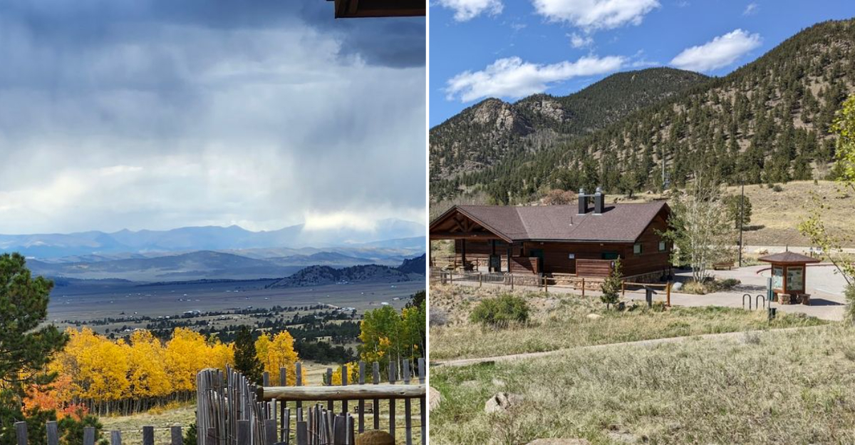
The One-Mile Scenic Trail Starting At The Visitor Center

Not every great trail in Colorado requires a permit, a shuttle, or a five-hour commitment. The one-mile loop that begins right at the Wilkerson Pass Visitor Center is proof that short and worthwhile are not mutually exclusive terms in the mountains.
The trail winds through a spread of aspens and open meadow, gaining just enough elevation to deliver elevated views without demanding anything athletic in return. Visitors who stop purely for the restrooms often end up wandering onto the trail almost by accident, which is exactly how the best unplanned detours tend to start.
The path is level enough for most fitness levels and short enough to complete before anyone in the car gets impatient.
In autumn, the aspens along this trail turn in a way that makes the whole hillside look like it has been lit from within. Even outside of fall color season, the trail offers a genuinely refreshing leg-stretch with mountain scenery that most dedicated hiking trails would be proud to claim.
Dogs are welcome on leash, and the trailhead is steps from the parking area.
Quick Tip: The trail offers elevated views back toward the overlook deck, giving you a slightly different perspective on the same mountain panorama from a higher angle.
The Gift Shop Stocked With Colorado Books And Local Souvenirs

There is a particular kind of gift shop that sells things you actually want to own rather than things you feel obligated to buy, and the Wilkerson Pass Visitor Center gift shop leans firmly toward the former category. Visitors have noted a solid selection of Colorado-specific books covering local history, geology, and regional wildlife that hold up well beyond the trip itself.
The Rockhound guide has been singled out as a genuine find, which makes sense given that Colorado’s geology is spectacular and most people driving through have no idea what they are looking at. Snacks are also available, which covers the practical end of the equation for anyone running low on road trip fuel between Woodland Park and Fairplay.
The shop is staffed and friendly on most visits, and the scale of it is manageable, meaning you can browse the entire thing in ten minutes without feeling overwhelmed or pressured. For families, it is the kind of stop where kids can pick one small souvenir without the decision becoming a forty-five-minute negotiation.
That alone earns it a permanent spot in the road trip itinerary.
Insider Tip: The Colorado history books available here make excellent post-trip reading that extends the experience well beyond the drive home.
Clean Restrooms That Actually Deserve The Compliment

Roadside restroom quality is a subject most travel writers skip politely, but visitors to Wilkerson Pass bring it up repeatedly and enthusiastically, which means it has earned a proper mention. Multiple visitors have described these as among the cleanest vault bathrooms they have encountered anywhere, which is a bar that is admittedly easy to clear but still matters enormously when you are two hours from the nearest town.
Baby changing stations are available, which immediately elevates the stop for families traveling with infants. The facilities have been consistently noted as well-maintained across visits spanning multiple years, suggesting that the upkeep is not a seasonal fluke but an actual operational standard.
That consistency is rarer than it should be at highway-adjacent rest areas.
The restrooms are open during visitor center hours, which run daily from 9 AM to 5 PM. A note posted at the facility indicates seasonal closure around early October, so late-season travelers should plan accordingly.
For anyone driving the Highway 24 corridor between Colorado Springs and Buena Vista, this stop functions as the most reliable comfort break on the entire stretch.
Common Mistakes to Avoid: Do not assume the facilities are available year-round. Seasonal closure typically begins around early October, so check before planning a late-fall pit stop.
Ample Parking Including RV-Friendly Spaces

Pulling a rig the size of a small apartment into a mountain parking lot is one of those activities that separates confident RV travelers from everyone else white-knuckling the steering wheel. Wilkerson Pass Visitor Center takes that stress off the table with dedicated RV parking spaces, specifically two slots designed to accommodate larger vehicles without the usual improvised gymnastics.
For standard passenger vehicles, parking is described consistently as plentiful, which is a genuine luxury at a popular Colorado overlook. The lot fills up on peak summer weekends, particularly around midday, but early arrivals and late-afternoon visitors generally find space without circling.
The layout is straightforward enough that arriving in an unfamiliar vehicle is not the adventure it might be at more cramped mountain pullouts.
Trash cans are provided throughout the parking area, and a dog walking zone is designated nearby, making the whole stop feel genuinely organized rather than improvised. For road-trippers who have learned the hard way that a good parking situation can make or break a spontaneous stop, this lot delivers a level of logistical comfort that is easy to take for granted until you have experienced the alternative.
Best Strategy: Arrive before 10 AM on summer weekends to secure a spot with easy access to the overlook trail and visitor center entrance.
Picnic Tables And Benches Throughout The Grounds

Eating a sandwich with a view of fourteen mountains is objectively better than eating the same sandwich in a parking garage, and Wilkerson Pass gives you that upgrade for free. The grounds are dotted with picnic tables and benches in quantities that visitors have described as abundant, meaning the competition for a spot is rarely fierce even during busy summer afternoons.
The placement of the seating areas takes advantage of the surrounding scenery without requiring any effort on the visitor’s part. You sit down, you unwrap whatever you packed, and the Rocky Mountains arrange themselves in front of you like they have been waiting for this moment.
For families making the drive from Colorado Springs toward Buena Vista or Salida, this is a natural midpoint lunch stop that requires no advance planning.
Couples traveling without kids tend to claim a bench near the overlook railing and stay far longer than they intended, which is a pattern that repeats itself across seasons. The seating areas also work well as a quiet reading spot or a place to review a map before deciding which direction to continue.
Simple infrastructure, used well, makes a bigger impression than it probably should.
Who This Is For: Road-trippers who packed lunch and need a scenic, no-cost spot to eat it without hunting for a restaurant in a small mountain town.
The Dog Walking Area For Four-Legged Road Trip Co-Pilots

Road trips with dogs operate on a completely different timeline than trips without them, and anyone who has driven through Colorado with a restless retriever in the backseat understands this deeply. Wilkerson Pass Visitor Center has a designated dog walking area, which is the kind of practical amenity that earns genuine loyalty from the traveling-with-pets crowd.
Trash cans are positioned throughout the property, including near the dog area, which signals that the facility has actually thought through the logistics of pet-friendly stops rather than just tolerating them. Dogs must remain on leash per posted signage on the property, so plan accordingly and bring your own bags for the sake of everyone sharing the space.
The surrounding grounds give dogs enough room to stretch properly after hours in a car, and the open-air setting means even anxious dogs tend to settle quickly once they hit the grass. For couples or families traveling with pets, this stop functions as a genuine reset point rather than a rushed five-minute scramble in a gas station corner.
The mountain air seems to do something positive for dogs and humans in roughly equal measure, which is a detail that never quite makes it into the brochures but should.
Quick Tip: Leash rules are enforced on the property, so keep gear accessible and skip the off-leash assumptions to keep the visit smooth for everyone.
The Informational Displays Inside The Visitor Center

The informational stands inside the Wilkerson Pass Visitor Center do something that most highway-adjacent facilities do not bother attempting: they make you genuinely smarter about where you are. Displays cover the regional geography, local wildlife, and the natural history of the South Park basin in a format that is accessible without being condescending.
For families with curious kids, the interior displays serve as a five-minute education that connects the view outside to the science behind it. Understanding why South Park sits at such a high elevation, or why the Mosquito Range has so many fourteeners clustered together, gives the scenery a layer of meaning that transforms a pretty stop into a memorable one.
Adults who skipped geography class and never looked back tend to find themselves genuinely engaged here.
The visitor center is staffed during operating hours, which run daily from 9 AM to 5 PM, and the staff have been described by many visitors as helpful and knowledgeable about the surrounding area. Whether you want trail recommendations, weather context, or just a confident answer about which mountain is which, the center functions as a reliable first stop before heading deeper into the Pikes Peak National Forest corridor.
Who This Is Not For: Anyone hoping for a deep-dive museum experience. The displays are informative and well-organized but intentionally concise, designed for travelers rather than researchers.