This Epic Road Trip Will Take You To 12 Jaw-Dropping Landscapes In Arizona
Arizona packs more visual drama into one state than most people see in a lifetime. Red rock towers rise against impossibly blue skies, slot canyons twist into shadowy mysteries, and ancient forests turn to stone under your feet.
I’ve chased sunsets across this state more times than I can count, and every trip reveals something that stops me mid-step and makes me reach for my camera.
This road trip strings together twelve of the most stunning landscapes Arizona has to offer, each one different enough to feel like you’ve crossed into another world.
Pack extra memory cards, because your phone storage won’t survive this adventure.
1. Horseshoe Bend
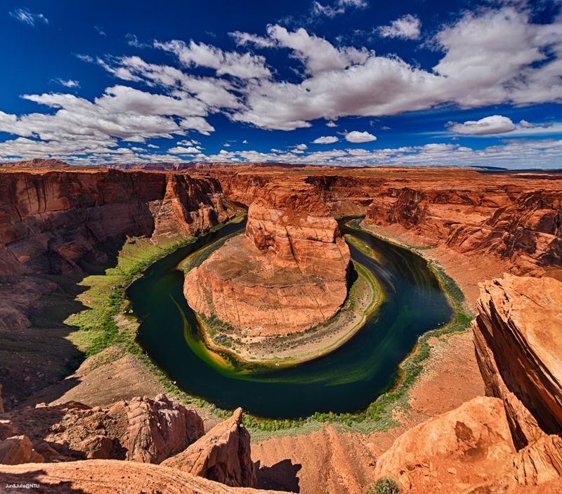
Standing at the edge of Horseshoe Bend feels like peering over the rim of the world.
The Colorado River carves a perfect horseshoe shape through rust-colored sandstone 1,000 feet below, and the view hits you with such force that your brain needs a moment to process the scale.
You’ll find this natural wonder at US Highway 89 between mile markers 545 and 544 in Page, AZ 86040, where a three-quarter-mile trail leads from the parking lot to the overlook.
I arrived mid-afternoon once and quickly learned my mistake as the harsh overhead sun washed out the canyon’s richness. Late afternoon into sunset transforms the scene completely, painting the cliffs in shades of amber and crimson while the river below shifts from green to deep turquoise.
The parking area now requires a fee, and the lot fills fast during peak season, so arrive earlier than you think necessary. The trail itself stays mostly flat and sandy, though the Arizona sun can turn that short walk into a test of endurance without water and sun protection.
Every time I watch the light change across those cliffs, I understand why people return here year after year.
2. Lower Antelope Canyon
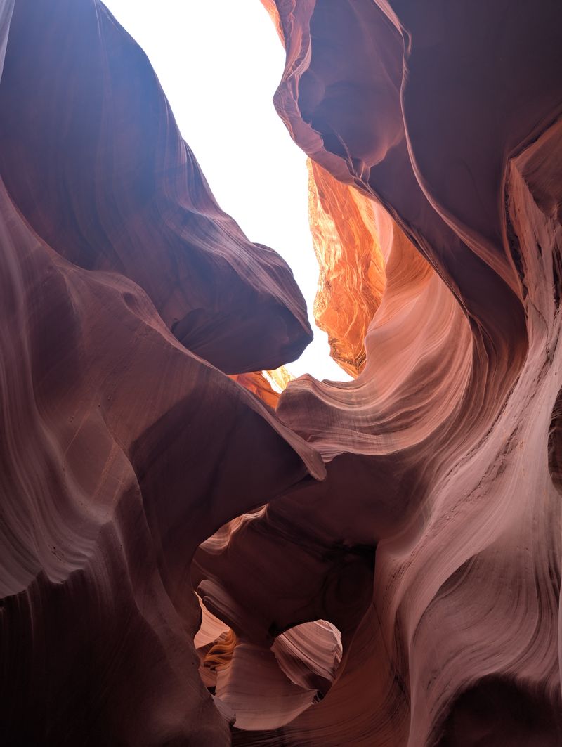
Lower Antelope Canyon proves that nature can sculpt rock into something that feels almost liquid.
Flash floods spent millennia carving these narrow passageways through Navajo sandstone, creating curves and swirls that photographers dream about.
Located on Indian Rte 222 in Page, AZ 86040, this slot canyon requires guided tour access only, which means you’ll need to book ahead and plan your day around your reserved time slot.
I’ve descended those metal staircases into the canyon multiple times, and each visit reveals different colors depending on the sun’s angle and the season. The walls glow in shades of orange, red, and purple, with occasional light beams piercing through the narrow openings above during the right months.
Tours run throughout the day, though midday tours catch the most dramatic light beams between March and October. The canyon floor stays relatively level once you’re down there, but those entrance stairs can challenge anyone uncomfortable with heights or tight spaces.
Your guide will point out formations that resemble animals or faces, though honestly, the abstract beauty of the flowing rock needs no interpretation to leave you speechless.
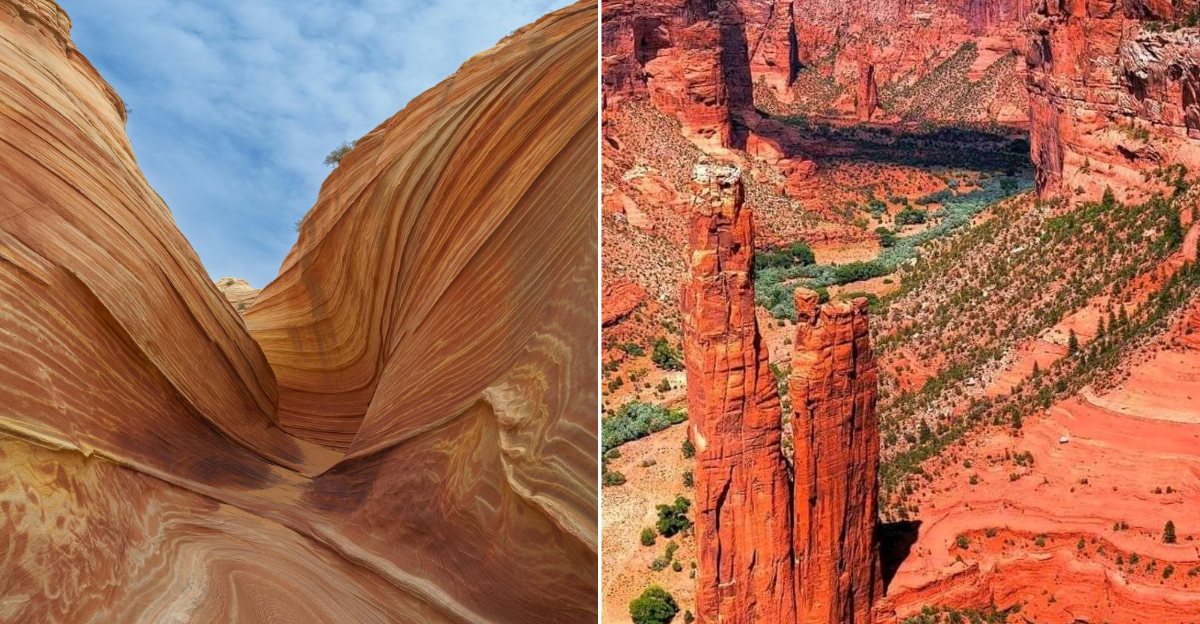
3. The Wave
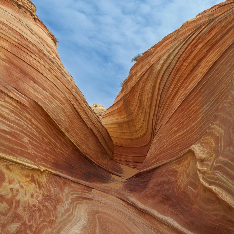
Winning a permit to visit The Wave feels like hitting the lottery, because that’s essentially what it is.
This geological marvel near Marble Canyon, AZ 86036 features sandstone formations that ripple across the landscape in bands of red, orange, yellow, and white, creating patterns that look more like abstract art than nature.
Access starts at the Wire Pass Trailhead area via House Rock Valley Road, but only twenty people per day receive permits through a lottery system that attracts thousands of applicants.
I’ve entered that lottery more times than I care to admit, and the one time I won felt like the universe finally acknowledged my persistence. The hike itself covers about six miles round trip across open desert with minimal shade, so summer attempts can turn dangerous quickly.
Navigation requires attention since the route lacks maintained trails, and GPS or downloaded maps become essential tools rather than optional extras. The formations themselves reward every ounce of effort spent reaching them, with curves and colors that shift as you move through the space.
Photography here becomes an all-day affair if you let it, as the changing light reveals new details in the rock patterns throughout the morning and afternoon.
4. Vermilion Cliffs National Monument
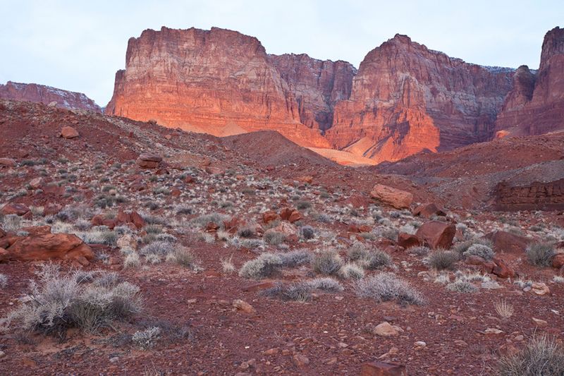
Vermilion Cliffs National Monument sprawls across nearly 300,000 acres of wilderness that most people only glimpse from Highway 89A.
Those massive red and orange cliff faces rise up to 3,000 feet above the surrounding desert near Marble Canyon, AZ 86036, creating a wall of color that dominates the northern Arizona landscape.
The monument’s remote nature means services don’t exist within its boundaries, so arriving with plenty of water, food, and fuel becomes non-negotiable.
I’ve explored different sections of this monument over several trips, and each visit reinforces how vast and varied the terrain truly is. California condors soar above the cliffs here, part of a reintroduction program that’s brought these massive birds back from the edge of extinction.
The monument includes The Wave and several other permit-restricted areas, but plenty of the landscape remains accessible without winning any lotteries. Dirt roads lead to trailheads and viewpoints, though high-clearance vehicles handle the routes more confidently than standard sedans.
Plan your visit with plenty of daylight remaining, as the remote location and lack of artificial light make navigation challenging after sunset.
5. Monument Valley Navajo Tribal Park
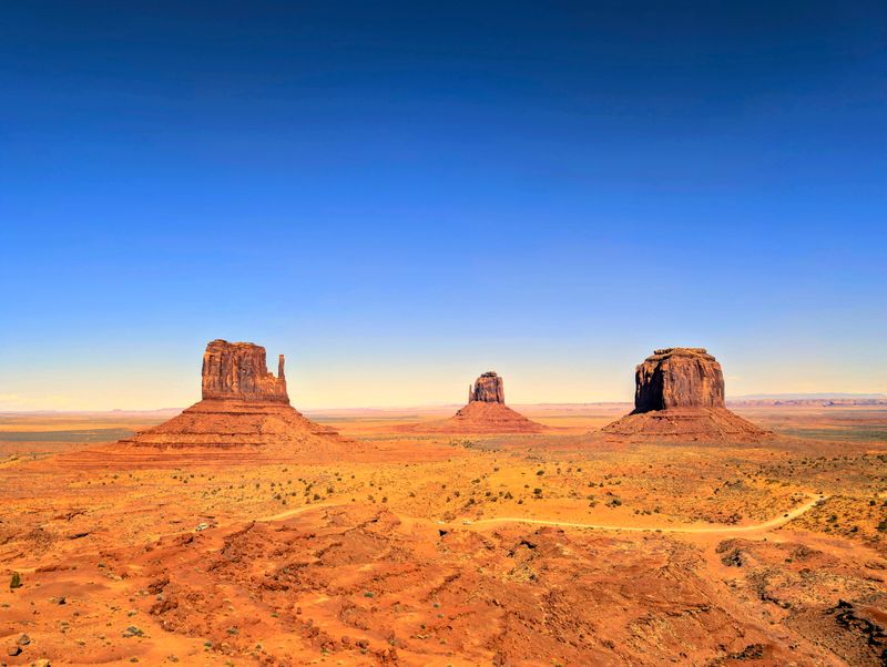
Monument Valley needs no introduction if you’ve ever watched a Western film or flipped through a photography book about the American Southwest.
Those iconic sandstone buttes and mesas rising from the desert floor at Monument Valley Visitor Center, 163 Scenic, Oljato Monument Valley, AZ 84536, have become shorthand for the entire region.
The park sits on Navajo Nation land, which means hours and access can vary by season and tribal considerations, so checking current conditions before you drive out saves disappointment.
I remember my first glimpse of the Mittens and Merrick Butte from the visitor center parking lot, and how the scale of those formations exceeded anything photographs had prepared me for.
The 17-mile loop drive takes you past the most famous formations, though the rough dirt road requires patience and careful driving.
Guided tours led by Navajo guides can access areas beyond the self-drive route, offering perspectives and stories that transform the landscape from scenic backdrop to living cultural space. Sunrise and sunset paint the red rock in constantly shifting shades, though midday light has its own stark beauty.
Every visit here reminds me why this place has captivated travelers and filmmakers for generations.
6. Canyon De Chelly National Monument

Canyon de Chelly wraps natural beauty and human history together in ways that few places manage.
Ancient Puebloan cliff dwellings cling to the red sandstone walls of this canyon system located 3 miles east of Highway 191 on Route 7 in Chinle, AZ 86503, creating scenes that connect you to people who called these cliffs home centuries ago.
The rim drives along both the north and south sides offer easy access to multiple overlooks, each revealing different perspectives on the 800-foot-deep canyons below.
I’ve stood at Spider Rock Overlook watching afternoon light illuminate that 750-foot sandstone spire rising from the canyon floor, and the view never gets old no matter how many times I return.
White House Ruin Trail provides the only self-guided route into the canyon, descending 600 feet to reach cliff dwellings you can approach up close.
Other canyon floor experiences require hiring authorized Navajo guides, who share stories and perspectives that guidebooks can’t capture. Cottonwood trees line the canyon bottom, turning brilliant yellow in autumn and creating color contrasts against the red rock walls.
The monument’s cultural significance to the Navajo people adds depth to every view and makes this more than just another pretty canyon.
7. Petrified Forest National Park
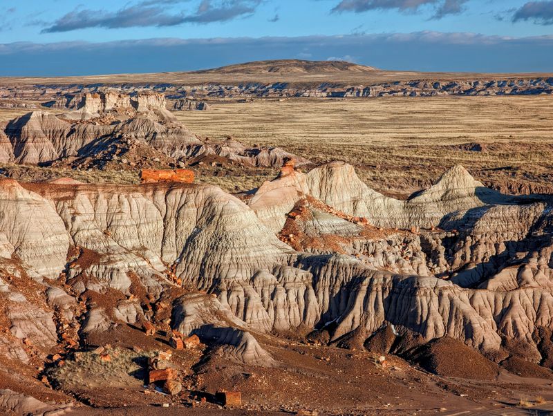
Petrified Forest National Park turns the concept of a forest completely sideways by replacing living trees with stone versions that fell 200 million years ago.
Located at 1 Park Rd, Petrified Forest National Park, this park preserves one of the world’s largest concentrations of petrified wood along with badlands, petroglyphs, and sections of Route 66 history.
The 28-mile scenic drive connects multiple stops and short trails, making this a perfect half-day or full-day adventure depending on how many sites you want to explore thoroughly.
I’ve walked among these stone logs multiple times, and the colors still surprise me with each visit. Reds, purples, yellows, and whites swirl through the crystallized wood where minerals replaced organic material cell by cell over millions of years.
Some logs measure over 100 feet long and several feet in diameter, lying scattered across the landscape like a giant’s abandoned lumber yard. Short paved trails lead to the densest concentrations of petrified wood, while longer backcountry routes offer solitude among the painted badlands.
The park’s north end includes sections of the Painted Desert, creating a seamless transition between these two geological wonders.
8. Painted Desert

The Painted Desert earned its name honestly, spreading bands of color across badlands that shift from red to purple to white depending on where you stand.
This geological wonderland shares an address with Petrified Forest National Park at 1 Park Rd, Petrified Forest National Park, AZ 86028, with the best viewpoints concentrated along the park’s northern section.
The colors come from different mineral deposits and oxidation levels in the clay and sandstone layers, creating a natural palette that artists spend careers trying to replicate.
I’ve photographed these badlands in morning light and late afternoon, and the difference in color intensity between those times proves dramatic. Morning light brings out cooler tones and subtle purples, while late afternoon sun ignites the reds and oranges into almost unnatural brilliance.
Several overlooks along the scenic drive provide easy access to sweeping views, though the Painted Desert Rim Trail lets you stretch your legs while taking in the landscape.
The desert’s appearance changes with weather conditions too, as clouds create moving shadows that add depth and drama to the layered hills. Plan time for multiple stops here, because each viewpoint reveals different color combinations and formations worth your attention.
9. Coal Mine Canyon
Coal Mine Canyon remains one of Arizona’s lesser-known geological gems, which means you might have the place almost to yourself.
Access comes off AZ-264 near mile marker 337.25, where you follow a dirt road toward a windmill and then carefully approach the canyon rim on foot.
This isn’t a developed park with guardrails and paved paths, so every step near the edge requires attention and respect for the 300-foot drop into the canyon below.
The canyon walls display bands of purple, gray, red, and white clay, creating color combinations I haven’t seen anywhere else in the state. Hoodoos and spires rise from the canyon floor in fantastical shapes that look like they belong on another planet.
I visited during late afternoon once and watched the low sun transform the purple layers into almost glowing ribbons of color against the darker shadows. No services exist out here, meaning you bring everything you need and pack out everything you bring.
The dirt access road can become impassable when wet, so check weather conditions before heading out. Visit in daylight with plenty of time remaining, because navigating this area after dark would be both difficult and dangerous.
10. Grand Canyon South Rim
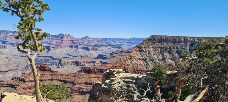
Grand Canyon South Rim delivers the classic Arizona experience that travelers fly across continents to witness.
Located at 8 S Entrance Rd, Grand Canyon Village, AZ 86023, this section of the canyon offers the most developed infrastructure and the most accessible viewpoints of the mile-deep chasm.
The scale hits differently than any photograph or description can prepare you for, as your eyes struggle to comprehend the distance from rim to river below.
I’ve arrived at sunrise to catch first light painting the canyon walls, and I’ve fought crowds at sunset when every viewpoint fills with people chasing that perfect shot. Early arrival solves most parking and viewpoint crowding issues, giving you space to absorb the view without constant jostling.
The Rim Trail connects multiple viewpoints along the edge, offering easy walking on mostly paved surfaces with constantly changing perspectives on the canyon’s depth and complexity. Shuttle buses run during peak season, removing parking stress once you’re inside the park.
Sunset brings out the warmest colors in the canyon walls, though the crowds at popular viewpoints like Mather Point and Yavapai Point can make the experience feel more social than serene.
11. Cathedral Rock Trail
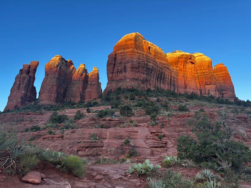
Cathedral Rock stands as Sedona’s most photographed formation, and one hike to the saddle between its spires explains why perfectly.
The Baldwin Trailhead area on Verde Valley School Rd in Sedona, AZ 86351, provides access to this short but challenging climb that gains 600 feet in less than a mile.
Those distinctive red sandstone spires rise nearly 1,000 feet above Oak Creek, creating a silhouette that’s become synonymous with Sedona itself.
I’ve hiked this trail in early morning light when the rock glows soft orange and the parking lot still has empty spaces. That parking situation becomes critical, as sunrise and sunset bring crowds that fill the small lot within minutes of the good light arriving.
The trail wastes no time getting steep, with some sections requiring use of hands to scramble up smooth rock faces. Reaching the saddle between the main spires rewards your effort with 360-degree views of Sedona’s red rock country and the green ribbon of Oak Creek below.
Many hikers continue beyond the saddle to explore the formation’s higher reaches, though the exposure increases significantly. Every visit here reminds me why Sedona attracts millions of visitors who come seeking exactly this combination of accessible beauty and moderate adventure.
12. Chiricahua National Monument
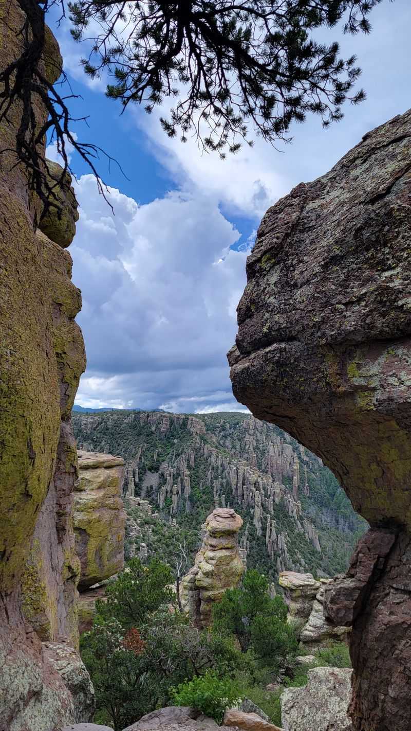
Chiricahua National Monument creates a landscape so unusual that early settlers called it the Land of Standing-Up Rocks.
Located at 12856 E Rhyolite Creek Rd in Willcox, AZ 85643, this monument preserves thousands of rock pinnacles, balanced rocks, and hoodoos formed from volcanic rhyolite.
The eight-mile Bonita Canyon Drive climbs from desert grassland through oak woodland into pine forest, offering viewpoints that showcase the monument’s geological peculiarities.
I spent a full day here once, hiking among the rock formations and discovering new perspectives around every turn. Some balanced rocks teeter so precariously on narrow pedestals that you expect them to topple at any moment, though they’ve held their positions for thousands of years.
The Echo Canyon and Heart of Rocks trails wind through the densest concentration of formations, creating a maze of stone columns that tower overhead. Early morning or late afternoon light adds drama to the already fantastic shapes, casting long shadows that emphasize every crack and crevice.
The monument’s remote location in southeastern Arizona means fewer crowds than more famous parks, giving you space to explore at your own pace. Plan a full day here if possible, because rushing through this place feels like leaving a museum before seeing half the exhibits.