
This Illinois State Park Hides A Waterfall-Filled Canyon You Can Hike All The Way Into
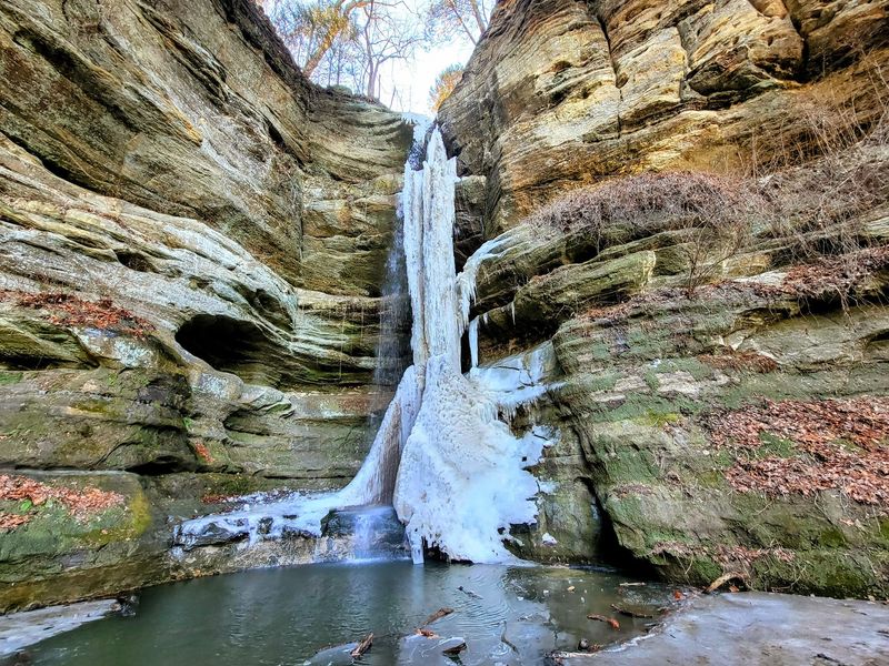
Tucked along the Illinois River in LaSalle County, Starved Rock State Park offers something most people never expect from the Land of Lincoln: sandstone canyons, dramatic overhangs, and seasonal waterfalls you can reach on foot. The park is no secret, but its rugged canyon landscape genuinely surprises visitors who picture Illinois as nothing but flat prairie and cornfields.
With 18 canyons and more than 13 miles of marked trails, the park gives hikers a chance to walk deep into narrow gorges and stand face-to-face with moss-covered walls and, when conditions cooperate, flowing waterfalls. Getting the most out of a visit means knowing what to expect before you lace up your boots.
Starved Rock Puts Canyon Country in Northern Illinois

Starved Rock State Park sits along the south bank of the Illinois River in LaSalle County, roughly equidistant from the towns of Utica, Oglesby, and Ottawa. According to the Illinois Department of Natural Resources, the park was established as Illinois’ second state park in 1911 and today encompasses 18 canyons and more than 13 miles of marked trails.
That combination of size, accessibility, and scenery has made it one of the most visited destinations in the state.
The canyon landscape is what catches people off guard. Most visitors arrive expecting a pleasant riverside park and find themselves walking between walls of ancient sandstone that rise well above their heads, with ferns clinging to damp ledges and the sound of dripping water echoing through narrow corridors.
The terrain looks more like the American Southwest than the Illinois most people picture.
Calling Starved Rock a hidden gem would be misleading. IDNR and Illinois State Police have previously addressed crowding, parking, and temporary closures when the park reached capacity, which tells you something about how popular it actually is.
The honest framing is that the park is well-known and heavily visited, but its canyon terrain can still genuinely surprise anyone who has only seen it described as a state park rather than experienced it in person.
For Illinois residents planning a day trip, that distinction matters. You are not discovering a wilderness secret; you are visiting a remarkable geological landscape that happens to be about two hours from Chicago, fully staffed, and equipped with trail maps, visitor center services, and marked routes into the canyons.
Glacial Floods and Sandstone Created the Canyons

The rock you walk between inside a Starved Rock canyon is St. Peter Sandstone, a formation deposited roughly 450 million years ago when a shallow sea covered this part of North America. What shaped it into the corridors and overhangs visitors see today is a much more recent story.
Illinois State Geological Survey research describes how massive glacial-meltwater floods scoured the region at the end of the last ice age, carving the Illinois River valley and leaving the sandstone bluffs exposed to ongoing stream erosion.
After the glacial floods receded, smaller streams continued cutting downward through the sandstone over thousands of years. That slower process created the individual canyons branching off the main bluff line, each one shaped by its own drainage pattern and the particular way water found a path through the rock.
The result is 18 distinct canyons, each with its own character, width, and depth.
The park’s geology and ecology information packet explains that the sandstone weathers unevenly, which is why some canyon walls feature dramatic overhangs while others slope more gradually. Water seeps through cracks and joints in the rock, feeding the mosses and ferns that give canyon interiors their lush, almost otherworldly appearance even when the waterfalls themselves have slowed to a trickle.
Understanding this geology helps set realistic expectations for the hike. A Starved Rock canyon is not a deep, continuously flowing gorge with a guaranteed river at its base.
Some are narrow ravines a few feet wide; others open into broader amphitheater shapes. Water levels at the canyon floor change dramatically with season and recent weather, which is exactly why the waterfall experience varies so much from one visit to the next.
Marked Interior Trails Reach Canyon and Waterfall Areas

When the article title says you can hike all the way into a canyon, it means following designated interior trails toward canyon bases and waterfall areas on foot, not scrambling up walls or bushwhacking through the brush. IDNR’s official trail information explains that green-marked interior canyon trails lead to the canyon and waterfall areas, while Brown, Green, and Red trail designations, paired with brown directional signs and maps posted at trailheads and intersections, help visitors navigate the full system.
Several canyon routes give a practical sense of what to expect. French Canyon is one of the shorter options, with a round-trip distance of approximately 0.8 miles from the trailhead.
Wildcat Canyon runs roughly 2 miles round trip. St. Louis Canyon and Aurora Canyon each come in around 3 miles round trip.
These distances reflect different starting points and route configurations, so they are best treated as general planning figures rather than exact measurements.
A separate IDNR trail-description document lists some distances differently, noting LaSalle Canyon at roughly 2 miles and Illinois Canyon at approximately 4.7 miles from the main trail system. Because trail-distance conventions can vary between one-way, round-trip, and route-segment measurements, always confirm which convention applies before planning your outing.
Not every canyon has an accessible waterfall. The IDNR FAQ identifies eight canyon areas with accessible waterfall sites, including French, Wildcat, LaSalle, Ottawa, Kaskaskia, Illinois, St. Louis, and Aurora.
Tonti Canyon is currently closed. Matching your route choice to the canyons on that list gives you the best chance of reaching a waterfall area, though flowing water still depends on the season and recent rainfall.
Waterfall Flow Follows Rain and Snowmelt

The waterfalls at Starved Rock are real, but they run on nature’s schedule, not the calendar. IDNR states that waterfalls commonly occur from March through June and may dry out from late June through October depending on rainfall.
Planning a visit around that window gives you the best odds of seeing flowing water without any additional research.
Spring is the strongest general season for waterfall flow. Snowmelt from late winter combines with spring rains to keep the canyon streams running, and the walls stay damp and moss-covered well into May.
Starved Rock Lodge’s hiking and waterfall guide echoes this, noting that March through May or early June typically offers the most reliable waterfall conditions across the park’s canyon system.
Summer is still worth the trip, just with adjusted expectations. The canyon walls, overhangs, and sandstone formations remain striking even when a waterfall has slowed to a seep or stopped entirely.
A substantial rain can revive flow at any point in the season, but IDNR does not publish routine waterfall-condition updates for every individual canyon. The park’s official FAQ is honest about this variability and advises visitors to check conditions before heading out.
Before any waterfall-focused visit, look at the weather history for Utica over the previous week. Two or three days of meaningful rainfall significantly improves the chances of seeing active flow.
Wet conditions also make the sandstone more hazardous, so a recent rain is a reason to check trail conditions as much as it is a reason to get excited about waterfalls.
The Hike Includes Stairs, Uneven Ground, and Changing Conditions

Anyone expecting a flat, leisurely walk through the canyons should know upfront that Starved Rock is not that kind of park. IDNR warns that canyon and overlook access involves major staircases, and the agency’s rough planning estimate is that an average person covers about one mile in 30 to 45 minutes on these trails.
That estimate accounts for the physical demands of the terrain and should be treated as a general guide, not a guaranteed pace.
The park’s accessibility information notes that overlook access can involve 50 to 150 steps, depending on the location. Surfaces throughout the trail system include uneven rock, exposed roots, wooden boardwalks that can be slick when wet, and steep canyon approaches.
Illinois Canyon is identified as the only trail system in the park without steps, but it includes a creek crossing that adds its own challenge, especially after heavy rain.
Wet sandstone deserves particular attention. IDNR press guidance on park safety notes that the sandstone can crumble and become slippery after rain, which is a meaningful hazard on steep approaches and near canyon edges.
Sturdy, closed-toe footwear with good grip is a practical choice, but no shoe choice substitutes for checking current trail conditions before you arrive.
Choosing the right route for your group matters as much as choosing the right day. Families with young children or visitors with limited mobility should review the accessibility page and trail distances carefully before committing to a canyon route.
A shorter canyon like French, at roughly 0.8 miles round trip, is a very different undertaking from the 4.7-mile Illinois Canyon route, and each presents its own combination of steps, terrain, and potential creek crossings.
Entering a Canyon Does Not Mean Leaving the Rules Behind

Walking into a canyon at Starved Rock feels like stepping into a different world, but the park’s rules follow you every step of the way. IDNR explicitly prohibits off-trail hiking, rock climbing, swimming, wading, and sliding in waterfalls or canyon creeks.
These are park rules, not informal suggestions, and they apply regardless of how inviting the water looks or how accessible a particular ledge might seem.
The prohibition on wading and swimming is especially relevant near waterfall areas. Canyon creek water may look clear and shallow, but the sandstone underneath can be unstable, slippery, or concealing uneven depths.
IDNR’s safety guidance reinforces that entering the water or scrambling onto canyon walls puts visitors at risk from crumbling rock and unexpected drops. Standing beneath an active waterfall is not a permitted activity and can be dangerous from falling debris.
The park’s FAQ confirms that fines for prohibited activities begin at $195, but the more important reason to follow the rules is physical safety. Canyon walls and overhangs that look solid can shed rock without warning, particularly after rain or freeze-thaw cycles.
Dogs are welcome on the trails but must remain leashed at all times. IDNR specifically warns visitors not to allow dogs to drink from canyon waterfalls, creeks, or the Illinois River, as the water may carry bacteria, algae, or other contaminants that are harmful to animals.
Keeping your dog on a short leash near canyon edges and water also protects the animal from falls on uneven terrain.
Check Weather, Parking, and Closures Before You Go

A visit to Starved Rock that skips the pre-trip homework can end in a closed trail, a full parking lot, or a soggy hike on a route that has been temporarily shut down. Official park hours list trails as open from 7 a.m. until sunset, with the visitor center open daily from 9 a.m. to 4 p.m.
Arriving early on weekends is consistently the best way to secure parking and avoid crowds on the most popular canyon routes.
Construction and storm damage can change access with little notice. As of mid-2026, IDNR’s trail-improvement closure update indicates that French and Wildcat Canyon access is available from the visitor center and lodge, while LaSalle and Tonti Canyon access and the Parkman’s Plain parking lot are closed for construction.
Those details are time-sensitive. Rely on the live closure page rather than any static article, including this one, for current access information.
IDNR’s current closures page covers all state sites and should be your first stop before finalizing a route. Storm damage, flooding, and seasonal maintenance can affect any trail at any time.
Checking it the day before or the morning of your visit takes about two minutes and can save a long drive to a closed trailhead.
Parking is a genuine constraint on busy weekends and holidays. IDNR has previously closed or restricted park access when lots reached capacity, and officials have warned against illegal roadside parking because it can block emergency vehicles.
Plan to arrive by 8 a.m. on peak days, have a backup plan if the main lot is full, and never park on the road shoulder as a workaround.
The Honest Payoff Is a Canyon Hike With a Chance of Waterfalls

Starved Rock State Park delivers something genuinely rare for a Midwestern day trip: a sandstone canyon landscape with marked routes that take you all the way to the canyon floor, surrounded by walls that dwarf you and formations that took thousands of years to carve. The waterfalls are a real part of that experience, but they are a seasonal bonus, not a guaranteed feature.
Spring or a recent stretch of meaningful rain gives you the best odds; summer offers the canyon scenery with less certainty about flowing water.
Matching your visit to the season, checking current trail closures before you leave home, picking a route that fits your fitness level, and following the park’s designated trails and rules is what turns a good idea into a great day out. The canyons are worth the trip whether or not the water is running, and the ones that do flow in season are genuinely hard to forget.