This Maine Scenic Drive Will Leave You Feeling On Top Of The World
There is a road in Maine where the sky seems closer than the next town, and the view can make even impatient drivers forget the clock. This western mountain route climbs through thick forest, bends past cold blue lakes, and rises toward a lookout that feels almost unfairly beautiful.
One minute, the pavement is tucked between trees. The next, the land opens wide, revealing water, islands, ridgelines, and miles of wild country layered into the distance.
It is not the kind of drive meant for rushing. It is the kind that turns a simple trip into a slow-motion reward, with every curve offering another reason to pull over, breathe deeper, and wonder how a road this cinematic still feels like a secret.
Maine’s Wild Western Road

Maine State Route 17 is a state highway that runs about 131 miles from Oquossoc in western Maine to Rockland on the coast, with its most scenic mountain stretch passing through the Rangeley Lakes region.
Its western mountain section passes through some of the most dramatic landscapes in the state, offering a mix of river valleys, dense forest, and high-elevation ridgelines that feel almost cinematic.
The scenic western portion of Route 17 runs through Oxford and Franklin counties, cutting across a region that many Maine visitors overlook. That is honestly part of its appeal.
You are not stuck in traffic or competing for parking spaces here. Instead, you get long, open stretches of pavement flanked by trees so tall and thick that sunlight filters through in golden ribbons.
For anyone who wants to experience Maine’s western mountains and lake country, the Route 17 stretch near Byron, Roxbury, Height of Land, and Rangeley is worth circling on your map first.
The View That Freezes Traffic

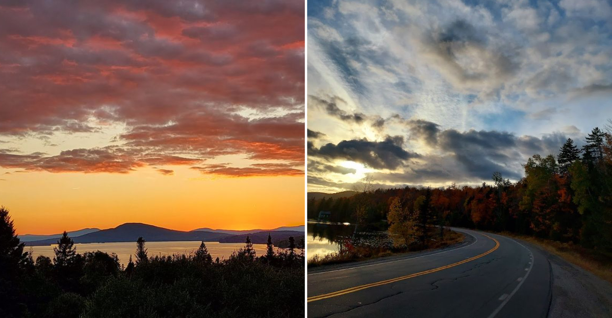
Without question, the crown jewel of this entire drive is the pullout known as Height of Land. Sitting at roughly 1,480 feet above sea level, this roadside overlook delivers a view so wide and so stunning that first-time visitors often just stand there with their mouths open, unsure where to look first.
Below the overlook stretches Mooselookmeguntic Lake, one of the Rangeley Lakes, shimmering in every light condition from sunrise gold to stormy gray.
The lake is enormous, and seeing it from above gives you a real sense of just how wild and unpopulated this corner of Maine truly is. Islands dot the surface, and forested ridges roll on endlessly in every direction.
There is a small parking area and a stone viewing platform that makes it easy to stop safely. I stayed here for almost an hour on my visit, watching the light shift across the water, and I still felt like I left too soon.
The Rangeley Lakes Region

The western end of Route 17 reaches Oquossoc and the Rangeley Lakes region, a cluster of lakes and ponds that sits high in the western Maine mountains. This area has been drawing outdoor enthusiasts for well over a century, and it is easy to understand why the moment you arrive.
The lakes here sit roughly between 1,200 and 1,500 feet in elevation, making the region one of Maine’s higher-elevation lake districts.
That altitude brings cooler summer temperatures, dramatic weather patterns, and a sense of remoteness that feels genuinely earned. The towns of Rangeley and Oquossoc sit at the edge of the water and offer a relaxed, no-fuss kind of charm.
Fishing, kayaking, and hiking all thrive in this pocket of Maine. Even just driving slowly through the region with the windows down, taking in the pine-scented air and watching the light play on the water, counts as a perfectly good afternoon well spent.
Peak Color, No Filter

If you time your visit to coincide with peak fall foliage, which typically runs from late September through mid-October in this part of Maine, you will witness something that feels almost too beautiful to be real.
The trees along Route 17 turn into a full-spectrum color show, with maples blazing orange and red, birches going bright yellow, and the dark green of spruce and fir keeping everything grounded.
The combination of the winding road, the elevation changes, and the sheer density of the forest means that the color wraps around you from every angle.
Looking out from Height of Land during peak foliage is a completely different experience than any other time of year. The lake below disappears into a sea of color, and the ridgelines look like they have been painted by hand.
Weekdays are noticeably quieter than weekends during foliage season, so if your schedule allows it, a Tuesday or Wednesday drive will feel much more peaceful and personal.
Moose Country Starts Here

Western Maine is moose country, and Route 17 passes through some of the best moose habitat in the entire state. These animals are enormous and surprisingly common along this corridor, especially in the early morning and around dusk when they tend to move toward water.
Spotting one standing at the edge of the trees or wading through a roadside pond is a genuine thrill that never gets old.
Beyond moose, the route also passes through habitat used by black bears, white-tailed deer, loons, bald eagles, and osprey. Birdwatchers will want to keep their binoculars within easy reach.
The lakes and wetlands along the route are particularly active with waterfowl during spring and fall migrations.
One practical note worth keeping in mind: moose can appear on the road suddenly and without warning, especially at night. Driving slowly and staying alert after dark is genuinely important here, not just a suggestion printed on a tourism brochure.
The Swift River Valley

As Route 17 descends from its highest elevations heading south, it follows the Swift River valley through a stretch of landscape that trades dramatic overlooks for something quieter and more intimate.
The river runs alongside the road for several miles, its clear water tumbling over rocks and pooling in calm eddies that practically beg you to stop and dip your feet in.
Byron, one of the smallest and most low-key towns in Maine, sits along this stretch. With a population that hovers around 100 people, it is the kind of place where the loudest thing you hear is moving water.
The surrounding forest is thick and mostly undisturbed, and the light in the valley during late afternoon takes on a warm, amber quality that photographers absolutely love.
This section of the drive also passes near Coos Canyon, a natural gorge carved by the Swift River that is free to visit and genuinely impressive up close, with swirling potholes and deep pools of clear water carved right into the bedrock.
Coos Canyon

Coos Canyon sits right along Route 17 in Byron, Maine, and it is one of those roadside natural attractions that consistently surprises people who stumble upon it for the first time.
The Swift River has spent thousands of years carving its way through a narrow granite gorge here, creating smooth, sculpted walls, deep spinning pools, and a rushing current that is both beautiful and powerful.
Access is completely free, and there is a small parking area right off the road. A short walk brings you down to the river level, where you can explore the rocks, peer into the deep potholes, and watch the water churn through channels barely wide enough to squeeze through.
On warm summer days, brave swimmers do take a plunge into the cold pools. Gold panning is also a real activity here, as the Swift River has historically yielded small amounts of placer gold.
You can rent pans from a small shop nearby and try your luck, making this stop genuinely fun for all ages.
The History Behind This Mountain Highway

Route 17 has a history that stretches back to the early days of automobile travel in Maine. The road was developed during a period when states were actively building infrastructure to connect rural communities and open up the interior for tourism and commerce.
Western Maine, with its lakes and forests, was seen as a destination worth reaching. The Rangeley Lakes region had already become a popular retreat for wealthy sportsmen from Boston and New York by the late 1800s, arriving by train and then by carriage.
As automobiles became common, the need for a proper road connecting the coast and the interior grew steadily. Route 17 eventually became one of the key road links through this part of western Maine, threading through terrain shaped by elevation changes, river valleys, and mountain lakes.
Today the road carries a mix of local traffic, logging trucks, and curious travelers, and it manages to feel both practical and special at the same time, which is a combination not many roads can honestly claim.
Four Seasons, Four Different Roads

Each season brings a different mood to Route 17, and honestly, there is no bad time to make the drive as long as you know what you are getting into.
Summer brings lush green forests, warm lake temperatures perfect for swimming, and long daylight hours that make the drive feel unhurried and generous with its scenery.
Fall is the showstopper season, as mentioned, but spring has its own quiet magic. The snow melts slowly at higher elevations, the rivers run fast and loud, and the first green of new growth appears against the gray tree trunks in a way that feels almost delicate.
Wildflowers appear along the roadside in May and June.
Winter turns the route into something completely different. Snow covers everything in thick, muffling silence, and the frozen lakes take on a blue-white stillness that is striking.
However, road conditions can be challenging in winter, and some services in the area close seasonally, so checking ahead before a cold-weather visit is a genuinely smart move.
Drive It Like A Local

A few practical details can make a real difference on this drive. Gas stations are sparse along the route, particularly between Byron and Rangeley, so filling up before you head out is worth doing rather than hoping for the best.
Cell service is also limited through much of the corridor, which means downloading offline maps before you leave is a genuinely useful habit.
Bring layers regardless of the season. The elevation at Height of Land means temperatures can drop noticeably compared to the valley below, and afternoon thunderstorms can roll in quickly during summer months.
A light jacket tucked into your bag has saved more than one roadside photography session from an uncomfortable ending.
Start the drive early in the morning if you can. The light is better for photography, the wildlife is more active, and you will have Height of Land mostly to yourself before the mid-morning crowd arrives.
Route 17 rewards patience and slow travel, so resist the urge to rush through it.