This Massive Ancient City In Illinois Once Rivaled London In Size
Long before Illinois became a center of modern industry, a remarkable civilization flourished on the banks of the Mississippi River, just across from present-day St. Louis. From 700 to 1400 AD, this once-thriving city was home to over 20,000 people, surpassing the population of London at the time.
I’ve stood atop towering earthen mounds, walked the vast plazas where people once gathered for ceremonial events, and marveled at the ancient timber circles used by astronomers to track the stars.
The site, now a UNESCO World Heritage treasure, offers a rare glimpse into the complex society of the Mississippian people.
It was a place of incredible urban planning, architecture, and astronomical knowledge, all built without written language or metal tools.
Exploring the site today, you can trace the remnants of this forgotten metropolis, which once thrived in the heart of the American Midwest, revealing a story of human achievement that’s far older than most realize.
A Population That Outgrew Medieval London
At its peak around 1100 AD, Cahokia housed an estimated 20,000 residents, a population that rivaled or exceeded that of London during the same era.
The scale becomes real when you realize this wasn’t just a village but a true urban center with organized neighborhoods, public spaces, and complex social structures.
Walking through the site today, you’ll find remnants of more than 80 earthen mounds scattered across the landscape.
These weren’t random hills but carefully constructed platforms that supported temples, elite residences, and ceremonial buildings. The city sprawled across six square miles, with residential areas radiating outward from the central plaza.
What strikes me most is how this civilization thrived without written language or metal tools. Every mound was built basket by basket, with workers hauling earth from borrow pits that still dot the landscape.
The organization required to coordinate such massive construction projects speaks to a sophisticated society with strong leadership and shared purpose that rivals any medieval European city of its time.
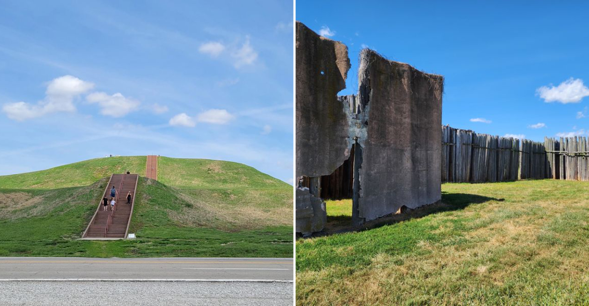
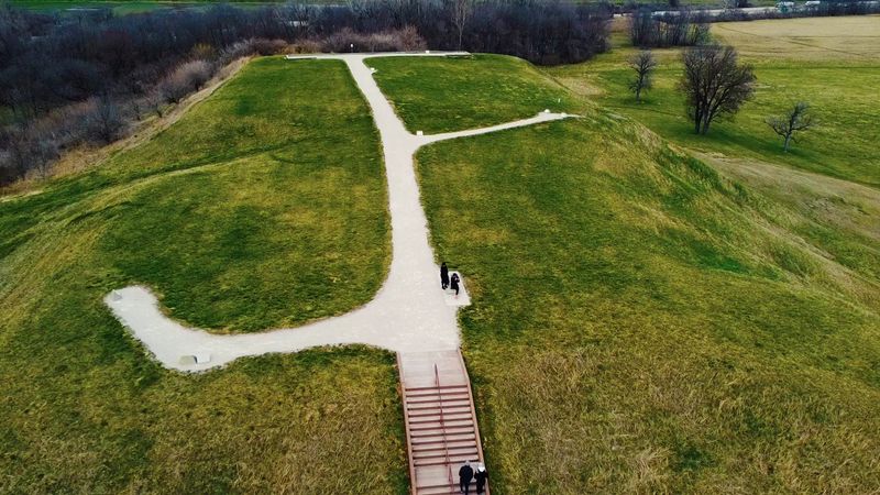
Standing atop Monks Mound, I couldn’t help but imagine the bustling city that once spread beneath my feet at Cahokia Mounds State Historic Site in Collinsville, Illinois at 30 Ramey St.
Monks Mound Towers Ten Stories High
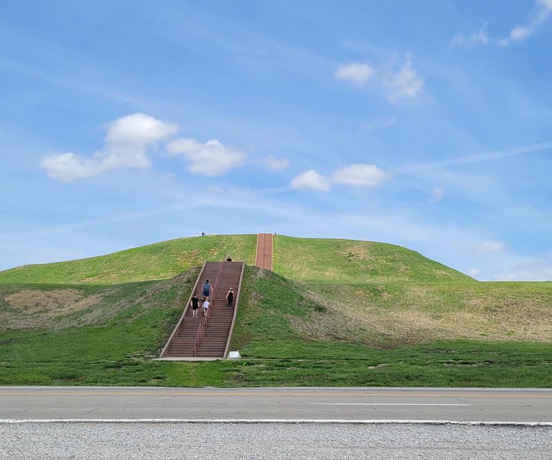
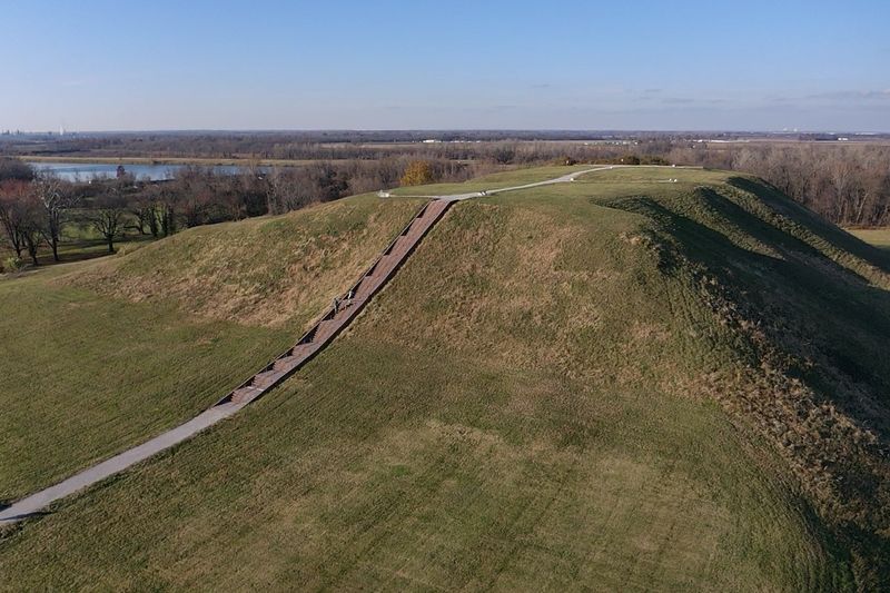
My legs burned halfway up the staircase, but I kept climbing. Monks Mound rises 100 feet into the Illinois sky, making it the largest prehistoric earthen structure in North America.
Built in fourteen stages over three centuries, this massive pyramid covers fourteen acres at its base and contains approximately 22 million cubic feet of earth.
The climb takes most visitors about ten minutes, with several landings providing rest stops and interpretive plaques explaining the mound’s history. When I finally reached the summit, the view knocked the wind right back into me.
On clear days, you may be able to spot the Gateway Arch gleaming in downtown St. Louis, creating a striking visual connection between ancient and modern civilizations.
French Trappist monks farmed the terraces in the early 1800s, giving the mound its current name. But long before them, this platform supported a massive building where Cahokia’s paramount chief lived and conducted ceremonies.
Archaeologists estimate it took 300 years to complete, with each generation adding layers to honor their leaders. The sheer persistence required to build something knowing your great-grandchildren would finish it demonstrates a cultural commitment that transcends individual lifetimes.
The Grand Plaza Hosted Thousands
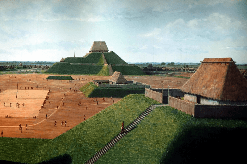
Imagine a space larger than 35 football fields, meticulously leveled and maintained as the ceremonial heart of an ancient city. The Grand Plaza at Cahokia served exactly that purpose, hosting religious ceremonies, sporting events, and public gatherings that brought the entire community together.
Walking across this vast green expanse today, I tried to picture it filled with thousands of people watching chunkey games or participating in seasonal rituals.
The plaza wasn’t naturally flat. Workers hauled countless baskets of earth to create this level surface, carefully grading it to ensure proper drainage.
They oriented it precisely with the cardinal directions, demonstrating the astronomical knowledge that permeated Cahokian culture.
Surrounding the plaza, elite residences and important public buildings created an impressive skyline of earthen architecture.
Archaeological evidence suggests the plaza surface was regularly maintained and resurfaced, much like modern public spaces require upkeep. This wasn’t a neglected field but a carefully curated civic space that reflected the city’s power and organization.
Standing there now, with only grass and silence, I felt the weight of all those vanished voices and footsteps that once animated this remarkable gathering place.
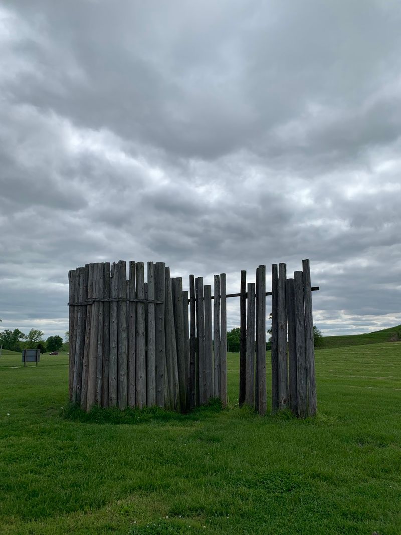
Woodhenge Tracked Celestial Events
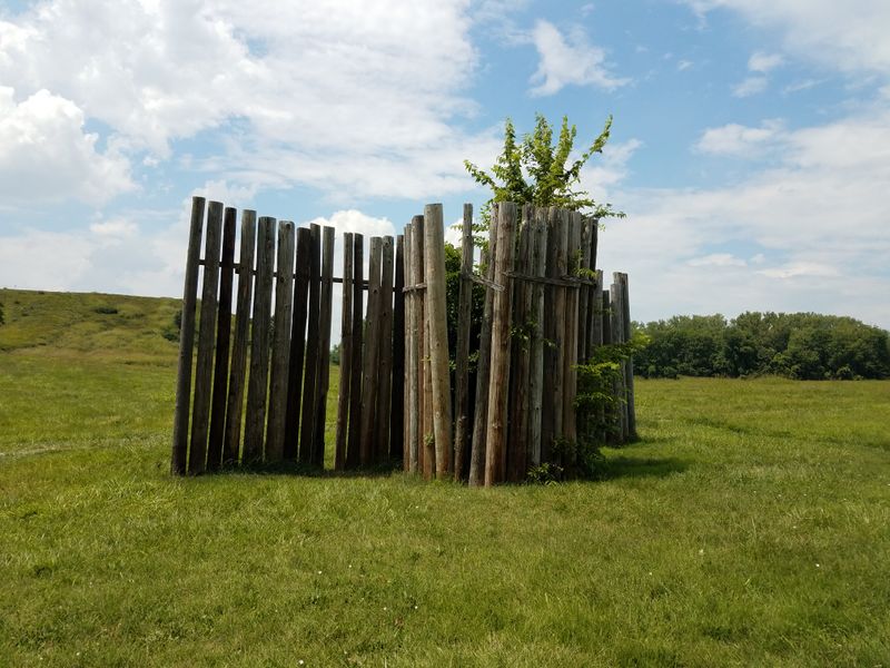
Cahokia’s astronomers were seriously committed to their craft. They constructed a series of large timber circles called Woodhenges, using red cedar posts up to 20 feet tall to track solar events throughout the year.
Standing at the center post during my visit, I aligned myself with the eastern markers and imagined witnessing the sunrise on the equinox, exactly where ancient observers predicted it would appear.
The reconstructed Woodhenge you’ll see today represents the third and largest version built at Cahokia. Archaeologists discovered postholes from five different circles constructed between 900 and 1100 AD, each one refined and expanded upon previous versions.
The final circle contained 48 posts arranged in a 410-foot diameter, creating what essentially functioned as a massive solar calendar.
Specific posts marked the summer and winter solstices, the spring and fall equinoxes, and other significant solar events. This knowledge allowed priests to predict seasonal changes, coordinate agricultural activities, and schedule religious ceremonies with precision.
The sophistication of these observations rivals that of other ancient astronomical sites like Stonehenge, focusing on solar events like solstices and equinoxes.
Walking around the circle, I appreciated how this wooden observatory connected Cahokians to cosmic rhythms that governed their agricultural and spiritual lives.
UNESCO Recognizes Global Significance
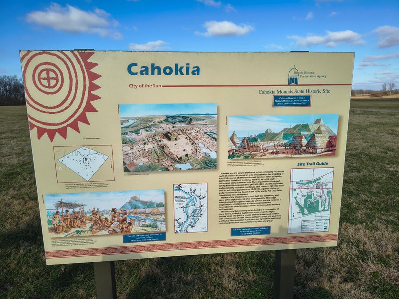
Only 24 UNESCO World Heritage Sites exist in the United States, and Cahokia earned its place among them in 1982.
This designation puts it in the same category as the Grand Canyon, Yellowstone, and the Statue of Liberty. Walking through the site, I noticed the UNESCO emblem on informational signs, a reminder that this place holds meaning far beyond Illinois or even America.
The designation recognizes Cahokia as having outstanding universal value to humanity. It represents the largest and most complex pre-Columbian settlement north of Mexico, providing irreplaceable evidence of sophisticated Native American civilization.
The site demonstrates urban planning, social organization, astronomical knowledge, and architectural achievement that challenges simplistic narratives about pre-contact America.
This international recognition brings both prestige and responsibility. It ensures preservation standards meet global expectations and attracts researchers from around the world who continue uncovering new insights about Mississippian culture.
During my visit, I overheard conversations in multiple languages, proof that Cahokia’s story resonates across borders.
The UNESCO status also helps secure funding for ongoing preservation and research, protecting these irreplaceable mounds for future generations who deserve to connect with this profound chapter of human achievement on the North American continent.
Over 80 Mounds Once Numbered 120
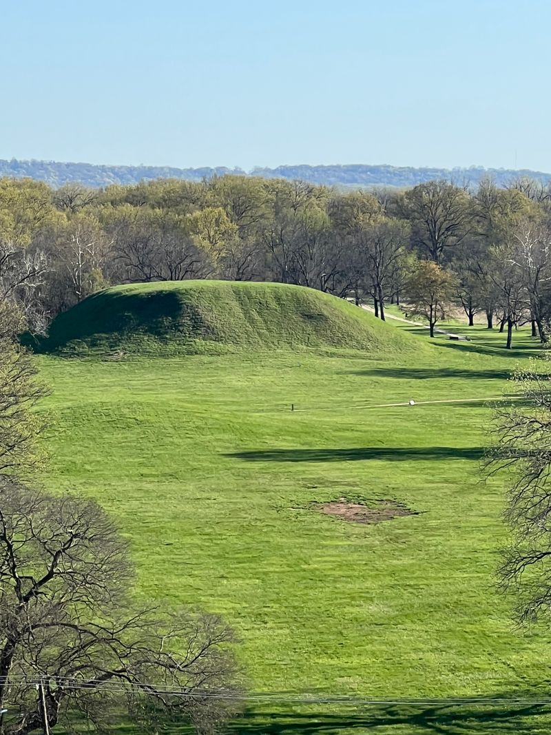
What you see today represents a fraction of Cahokia’s original grandeur. Archaeologists estimate at least 120 mounds once dotted the landscape, but urban development, farming, and simple erosion have claimed about 40 of them.
Walking between the 80 surviving mounds, I felt both grateful for what remains and heartbroken about what we’ve lost forever.
Each mound served specific purposes within Cahokian society. Platform mounds supported important buildings and elite residences.
Ridge-top mounds marked boundaries and served ceremonial functions. Conical mounds often contained burials, though not all were used as tombs.
The variety in mound shapes and sizes reflects the complex social organization that characterized this ancient city.
Some mounds across the highway from the main site are now surrounded by modern houses and roads, highlighting the impact of urban encroachment on the preservation of these ancient structures.
The interpretive center property protects the core archaeological zone, but the original city extended far beyond current boundaries. Many mounds were destroyed before anyone recognized their significance.
Farmers plowed them flat, developers leveled them for construction, and early settlers used them as convenient sources of fill dirt. The mounds that survived did so partly through luck and partly through growing awareness of their irreplaceable historical value.
Advanced Agricultural Society Sustained Growth
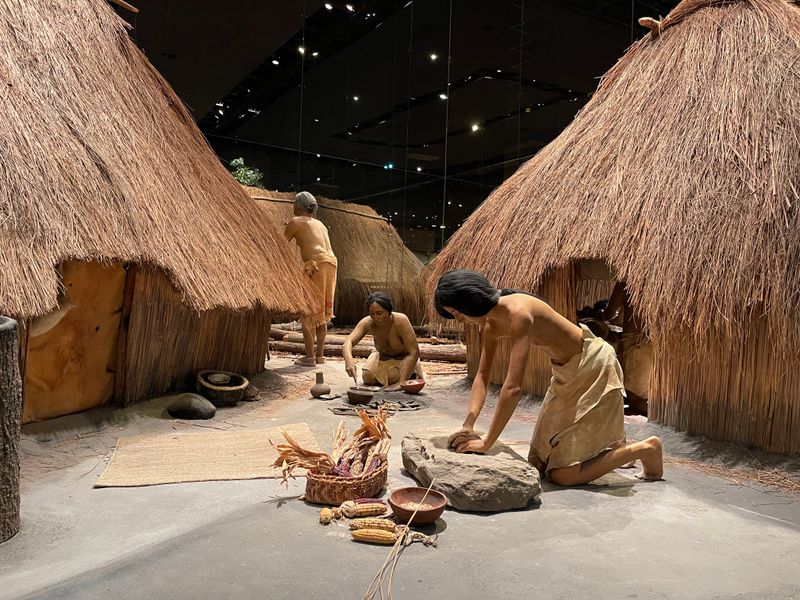
You can’t sustain 20,000 people without serious agricultural know-how. The Mississippian people who built Cahokia developed sophisticated farming techniques that produced reliable surpluses, enabling population growth and freeing some residents to specialize in crafts, construction, and administration.
Learning about their agricultural innovations at the interpretive center, I gained new respect for their practical genius.
Corn formed the backbone of their diet, supplemented by beans, squash, sunflowers, and other domesticated plants. They practiced crop rotation and understood soil management long before European contact.
The fertile Mississippi River floodplain provided excellent growing conditions, and Cahokians exploited this advantage brilliantly. They also hunted deer, gathered wild plants, and fished the nearby rivers, creating a diverse food economy.
Storage became crucial as the population grew. Large granaries held surplus corn that could sustain the city through winters and poor growing seasons.
This food security allowed Cahokia to support not just farmers but also artisans, builders, priests, and administrators.
The agricultural foundation made everything else possible, from monumental construction projects to long-distance trade networks.
Without their farming expertise, those impressive mounds would never have risen from the Illinois prairie, reminding us that civilization’s grandest achievements rest on humble seeds planted in rich earth.
Trade Networks Stretched Across North America

Cahokia wasn’t isolated on the prairie. Archaeologists have uncovered materials from across North America, proving this city sat at the center of vast trade networks that connected the Great Lakes to the Gulf Coast and the Atlantic to the Rockies.
Examining artifact displays, I marveled at shells from Florida, copper from Lake Superior, and mica from the Appalachians, all found at this Illinois site.
These trade connections weren’t just about acquiring exotic materials. They facilitated cultural exchange, spread religious ideas, and established Cahokia’s influence across a huge territory.
Smaller settlements throughout the Midwest and Southeast adopted Mississippian cultural practices, architectural styles, and religious symbolism, creating what archaeologists call the Mississippian Interaction Sphere.
The logistics of maintaining these networks impresses me. Without wheeled vehicles or horses, traders traveled by foot and canoe, carrying goods hundreds or thousands of miles.
They followed rivers, established trails, and created relationships with distant communities. Cahokia likely controlled or influenced key transportation routes, enhancing its economic and political power.
The city’s central location near the confluence of the Mississippi, Missouri, and Illinois rivers made it a natural hub for continental commerce.
This geographic advantage, combined with strong leadership, transformed Cahokia into something unprecedented in North American prehistory.
Mysterious Decline Around 1400 AD
Here’s the question that haunts archaeologists and fascinated me during my visit: why did Cahokia decline? By 1400 AD, this once-thriving metropolis stood largely abandoned, its plazas empty and its mounds silent.
No definitive answer exists, but researchers have proposed several theories that likely worked in combination to trigger the city’s collapse.
Environmental factors probably played a role. Evidence suggests deforestation around Cahokia caused erosion and reduced game populations.
Climate change brought cooler temperatures and unpredictable growing seasons, threatening food security.
The concentrated population may have depleted local resources faster than they could regenerate. Some researchers point to flooding events that disrupted agriculture and damaged infrastructure.
Social and political factors matter too. Perhaps internal conflicts weakened central authority.
Some researchers suggest that the religious system that legitimized elite power may have lost credibility, contributing to social instability.
External pressures from rival groups could have disrupted trade networks or threatened security. Disease outbreaks might have devastated the dense urban population.
Whatever combination of factors caused the decline, people gradually dispersed to smaller communities.
The descendants of Cahokia’s builders continued living throughout the region, but they never rebuilt a city of comparable size. Standing on Monks Mound, I wondered what those final residents thought as they watched their magnificent city slowly empty around them.
Ongoing Archaeological Research Reveals New Insights
Cahokia keeps surprising researchers. Despite decades of study, new discoveries continue reshaping our understanding of this ancient city.
During my visit, I learned about recent projects using ground-penetrating radar, drone surveys, and other technologies to map buried features without excavation. These non-invasive techniques reveal structures and patterns invisible from ground level.
Recent research has identified previously unknown residential areas, ceremonial spaces, and defensive features. Scientists now understand that Cahokia’s influence extended even farther than previously thought, with satellite communities connected to the main city through shared cultural practices and likely political ties.
Analysis of skeletal remains provides insights into diet, health, and social status, painting a more detailed picture of daily life.
The interpretive center is closed for renovations through 2025, but the grounds, trails, signage, and mounds remain open for visitors. The grounds remain open with trails, signage, and the mounds themselves to explore.
When the center reopens, it will feature updated exhibits incorporating the latest research findings. Each new discovery adds another piece to the puzzle of how Cahokia functioned and why it mattered.
As I walked the trails, I appreciated that this site isn’t frozen in time but continues teaching us about human achievement, adaptation, and the complex societies that thrived in North America long before European contact.