This Remarkable 120-Mile Arizona Drive Winds Through Some Of The Most Gorgeous Scenery On Earth
They told me the road would be demanding, but nobody mentioned that it would be transformative. When I set out on the Coronado Trail Scenic Byway, I expected a simple commute through the wilderness, but what I found was a rugged masterclass in perspective.
This remarkable 120-mile Arizona drive winds through some of the most gorgeous scenery on earth, offering a relentless parade of jagged canyons and hidden valleys that seem to breathe alongside me.
With over four hundred curves waiting to test my focus, I felt my urban anxieties evaporate into the thin, crisp mountain air. There is something profoundly humbling about being a tiny spec of motion against such an ancient, towering backdrop.
By the time I reached the final bend, I felt as though I’d driven right off the map and into a dream.
The Wild, Winding Road Itself

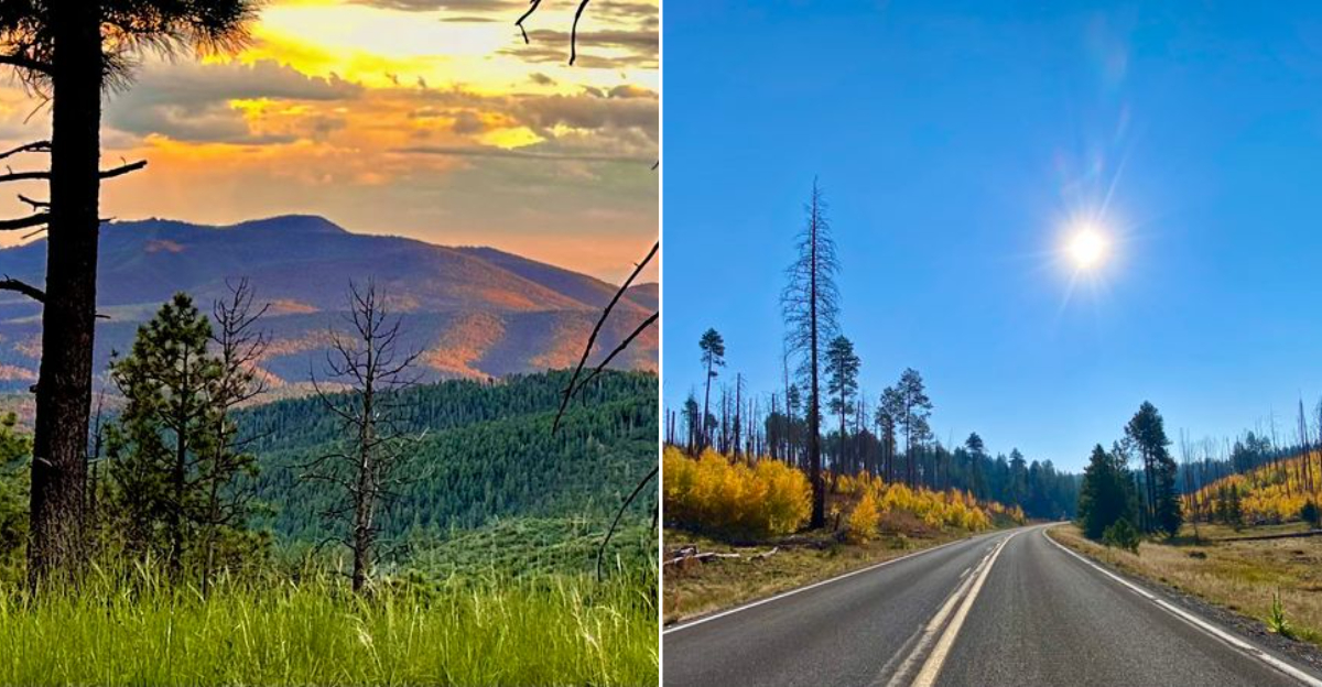
Forget smooth superhighways with gentle curves and predictable scenery. The Coronado Trail is famously described as one of the most challenging paved drives in the United States, and that reputation is completely earned.
With more than 400 curves and switchbacks packed into 120 miles, some sections slow traffic to a crawling 10 miles per hour. I took my time on this road, and honestly, rushing would be a mistake. Certain stretches have no guardrails, and the drop-offs beside the pavement will get your full attention fast.
The road was once numbered US 666, earning the nickname “The Devil’s Highway” for its punishing layout.
Plan on four to five hours of driving time, not counting stops, and start with a completely full tank of gas. Services along the route are extremely limited, and running low on fuel in the middle of the Apache-Sitgreaves National Forest is not the adventure you want.
Patience and preparation make this drive pure pleasure.
Dramatic Elevation Changes And Shifting Landscapes

One of the most jaw-dropping things about this drive is how completely the landscape transforms around you. Starting near Clifton and Morenci in the south, the terrain is classic Sonoran desert with rocky hillsides, sparse vegetation, and baking heat.
Then the road climbs, and everything shifts. By the time you reach the higher elevations, tall ponderosa pines close in on both sides, the air cools noticeably, and the whole mood of the drive changes.
The elevation difference from the lowest to the highest points along the route is roughly 5,000 feet, which is an extraordinary range for a single road.
I found myself stopping repeatedly just to absorb how different each new stretch looked from the last. Cactus gives way to meadow grass, meadow grass gives way to dense forest, and then suddenly a canyon opens up and steals your breath all over again.
This byway does not repeat itself, and that relentless variety is exactly what keeps it so captivating mile after mile.
Blue Vista Scenic Overlook At 9,190 Feet

Pulling off at the Blue Vista Scenic Overlook felt like the road had been building toward this moment the entire time. Sitting at 9,190 feet above sea level, this viewpoint delivers one of the most expansive vistas I have ever seen from a car window in Arizona.
Layers of forested ridges roll away toward the horizon in every direction, and on a clear day the view stretches for what feels like forever. The air up here carries that sharp, clean smell of high-altitude pine forest, and the temperature is noticeably cooler than the desert far below.
Bring a jacket even in summer, because the breeze at this elevation has real bite to it. The overlook has a small pullout area where you can park safely and walk to the edge for unobstructed photos.
Early morning visits reward you with soft golden light that makes the ridgelines glow in a way that afternoon sun simply cannot replicate. This spot alone justifies the entire drive.
Hannagan Meadow And Its Hidden Lodge

At 9,300 feet, Hannagan Meadow is the highest named point along the entire byway, and it has a quiet, almost secretive quality that I did not expect. The meadow opens up suddenly after miles of dense forest, and the contrast is striking.
Green grass, wildflowers in season, and a stillness that makes you want to just sit and listen. Tucked at the edge of the meadow is the Hannagan Meadow Lodge, the only lodging option along the entire 120-mile route.
The lodge has been welcoming travelers since the 1920s and offers cabins, a small restaurant, and a genuine sense of stepping back in time. In winter, the meadow becomes a hub for cross-country skiing enthusiasts, and the snow-covered pines create a scene straight off a postcard.
I stopped for lunch at the lodge on my drive through, and the warm, unhurried atmosphere made it genuinely hard to leave. If you can afford an overnight stay here, do it without hesitation.
Wildlife Encounters Along The Route

This road is alive in the most literal sense. I spotted elk grazing just off the pavement twice during my drive, and each time my heart rate jumped before I even fully registered what I was seeing.
The Apache-Sitgreaves National Forest supports an impressive range of wildlife, and the byway cuts right through the heart of it.
Mule deer, antelope, black bears, and bald eagles are all commonly reported along the route. The area is also one of the few places in the United States where Mexican gray wolves have been reintroduced, making a sighting rare but genuinely possible.
The Sipe White Mountain Wildlife Area near the northern end of the byway is a dedicated stop worth adding to your itinerary. Elk, osprey, and golden eagles are frequently seen there, and the viewing conditions are excellent.
Drive slowly, keep your camera accessible, and scan the tree lines constantly. The wildlife along this road is not shy, and the encounters feel wonderfully unscripted.
The Mountain Town Of Alpine And Its Character

Midway along the byway sits Alpine, a tiny mountain community that punches well above its weight when it comes to charm. Often described as having a Swiss village atmosphere, Alpine sits at around 8,050 feet and feels refreshingly unhurried in a way that larger towns simply cannot fake.
The community has a handful of small shops, a few places to grab a meal, and the kind of friendliness that reminds you why small-town road trips are worth taking. I stopped here to stretch my legs and ended up chatting with a local for twenty minutes about the best pullouts further south on the route.
Alpine also serves as a practical resupply point, so fill up your gas tank and grab any snacks you need before continuing south into the more remote sections of the drive.
The surrounding meadows and forests make this area popular with hikers and mountain bikers in summer. It is a genuinely pleasant place to pause and reset before the road gets really dramatic.
The Morenci Copper Mine And Southern Gateway

The southern end of the Coronado Trail delivers one final surprise that catches most first-time drivers completely off guard. As the road descends toward Clifton and Morenci, the Morenci open-pit copper mine comes into view, and the scale of it is genuinely staggering.
One of the largest copper mines in North America, Morenci is a massive terraced excavation carved into the earth in shades of rust, grey, and brown. Seeing something so enormous and industrial after hours of pristine wilderness creates a jarring but fascinating contrast that stays with you.
The twin cities of Clifton and Morenci mark the official southern terminus of the byway, and both towns have a rugged, working-class character rooted in the mining industry. Clifton in particular has some beautifully preserved historic architecture worth a short walk to appreciate.
Ending the drive here feels earned, like finishing a long chapter in a book that kept surprising you right up to the final page.
Ancient Apache History And The Land Beneath Your Tires

Long before any paved road existed here, this land belonged to the White Mountain Apache people, and that presence still echoes powerfully across every canyon and ridgeline you pass.
The Apache-Sitgreaves National Forest, which cradles much of the Coronado Trail, holds thousands of years of cultural history within its borders. Stopping at a pullout and simply looking out at the landscape connects you to something much older than any highway.
Many travelers focus on the scenery and forget the rich human story woven into these mountains. Local tribal communities in the region welcome respectful visitors who take time to learn.
Picking up a book or visiting a nearby cultural center before your drive adds a whole new layer of meaning to every mile you cover. That extra context changes the drive from a pretty route into a more thoughtful experience.
The cliffs, forests, and overlooks start to feel less like scenery and more like living history. It reminds you that the Coronado Trail is not only a mountain road, but also a passage through land with deep cultural roots.