This Scenic Drive Through Arizona’s Desert Will Show You A Hidden Paradise
Arizona State Route 88, better known as the Apache Trail, winds through some of the most breathtaking desert landscapes you’ll ever see. This historic roadway stretches roughly 40 miles from Apache Junction to Theodore Roosevelt Dam, offering views that’ll make your jaw drop.
Whether you’re a nature lover, history buff, or adventure seeker, this drive promises memories that last a lifetime. For me, nothing beat pausing at a quiet overlook, sipping coffee, and just soaking in the endless desert horizon-it felt like the world had slowed down for a moment.
Canyon Lake Marina And Recreation Area
Canyon Lake sits like a sparkling jewel tucked between towering canyon walls about 15 miles into your Apache Trail journey. The marina here rents kayaks, paddleboards, and fishing boats if you want to get out on the water.
Steamboat cruises depart daily, offering 90-minute narrated tours through the canyon’s dramatic cliffs. The lake was created in 1925 when Mormon Flat Dam was built on the Salt River. Wildlife sightings are common, with bighorn sheep occasionally spotted on the rocky slopes above.
Pack your camera because the contrast between blue water and rust-colored rocks creates postcard-perfect photos. Arrive early on weekends since parking fills up fast during peak season.
Tortilla Flat Historic Town

Population six. That’s right, Tortilla Flat claims the title of Arizona’s smallest official community, and every resident probably knows your name by the time you leave. This quirky roadside stop features a general store, saloon, and restaurant decorated with thousands of dollar bills pinned to the walls and ceiling.
Built as a stagecoach stop in 1904, the town survived a fire in 1987 that destroyed most original structures. Today’s buildings capture that Old West spirit with wooden boardwalks and rustic charm. The restaurant serves up killer prickly pear ice cream that tastes way better than it sounds.
Live country music plays on weekends, drawing motorcyclists and road trippers who swap stories over cold drinks. It’s the perfect halfway point to stretch your legs and soak up some genuine Arizona character.
Fish Creek Hill Switchbacks
Buckle up because Fish Creek Hill delivers the most thrilling section of the entire Apache Trail experience. The road transforms from paved highway to graded dirt as it plunges down a series of tight switchbacks carved into the mountainside.
This stretch drops about 1,500 feet in elevation over just a few miles. Large RVs and trailers aren’t recommended beyond Tortilla Flat for good reason. Pull over at the overlook before descending to appreciate the engineering marvel that allowed this road to exist.
I remember my first time navigating these curves, convinced my sedan wouldn’t make it. The road is maintained regularly though, and passenger cars handle it fine with cautious driving.
Apache Lake Overlook
Apache Lake stretches out below like a mirage, its deep blue waters contrasting sharply with the surrounding burnt-orange cliffs. This reservoir formed behind Horse Mesa Dam in 1927 and extends for 17 miles through some seriously remote country.
Unlike Canyon Lake, Apache Lake sees fewer visitors, making it perfect for folks seeking solitude. The lake reaches depths of 250 feet in some spots, supporting populations of bass, catfish, and crappie. A marina operates at the far end, accessible by continuing on the trail or by boat.
Bring binoculars because bald eagles nest in the area during winter months. The silence here feels almost sacred, broken only by occasional bird calls echoing off canyon walls.
Theodore Roosevelt Dam And Bridge
Standing 357 feet tall, Theodore Roosevelt Dam marks the official end of the Apache Trail and represents a massive achievement in early 20th-century engineering. Construction began in 1903 and took eight years to complete, requiring workers to haul materials by wagon along the very trail you just drove.
Roosevelt Lake behind it is Arizona’s largest reservoir, capable of holding over 2 million acre-feet of water. The elegant arched bridge spanning the canyon opened in 1990, replacing the original crossing. Visitor facilities include restrooms, picnic areas, and interpretive signs explaining the dam’s history.
Walk across the bridge for killer views looking down at the dam’s face and up at the lake. It’s a fitting finale to your desert paradise adventure.
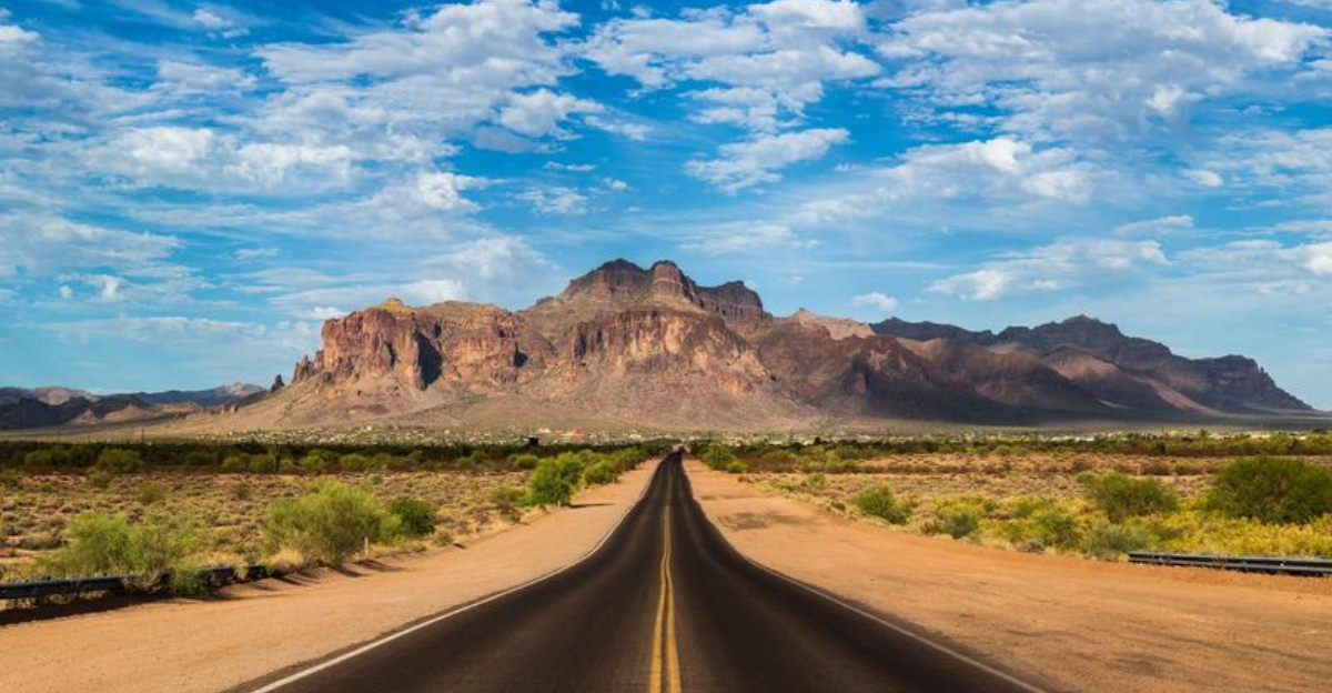
Superstition Mountains Backdrop
The Superstition Mountains loom over the western portion of your drive like ancient sentinels guarding lost treasure. These jagged peaks reach elevations over 5,000 feet and have inspired countless legends, most famously the Lost Dutchman’s Gold Mine.
Apache warriors once considered these mountains sacred, warning settlers to stay away from their spiritual grounds. Volcanic activity millions of years ago created the dramatic rock formations you see today. Saguaro cacti dot the lower slopes while higher elevations support pinyon pines and juniper trees.
Hiking trails branch off from various points along the Apache Trail, ranging from easy nature walks to challenging backcountry routes. The mountains change color throughout the day, glowing golden at sunrise and deep purple at sunset. They’re called Superstition for good reason.
Desert Wildlife Encounters
Keep your eyes peeled because the Apache Trail corridor hosts an impressive variety of desert creatures adapted to harsh conditions. Bighorn sheep navigate impossibly steep cliffs with ease, their tan coats blending perfectly with surrounding rocks.
Javelinas travel in small herds, rooting through vegetation with their pig-like snouts. During cooler months, rattlesnakes sun themselves on rocks near the roadside, so watch where you step during photo stops. Coyotes appear at dawn and dusk, their howls echoing through canyons as darkness falls.
Last spring, a family of coatimundis crossed right in front of my car near Tortilla Flat. Their ringed tails held high as they marched single-file into the brush.
Wildflower Season Transformation
Spring rains transform the Apache Trail into a botanical wonderland that rivals any garden you’ve ever visited. Mexican gold poppies carpet hillsides in brilliant orange while purple lupines create stunning color contrasts.
Peak wildflower season typically runs from late February through April, depending on winter rainfall amounts. Ocotillo plants send up dramatic red blooms at the tips of their spiny branches. Brittlebush adds splashes of yellow throughout the landscape while desert marigolds persist even into early summer.
The transformation happens quickly, so timing your visit right matters. Check with local ranger stations for current bloom reports before planning your trip during spring months.