This Texas Hidden Route Roundup Leads To Small Town Calm And Big Landscapes
Texas backroads taught me to breathe differently. Once you leave the interstate, the lanes narrow, the sky somehow widens, and the clock stops feeling so important.
I have rolled past rusted trucks sinking into fields, tiny schools with faded mascots, and gas stations where the clerk still asks where you are headed. The towns come slowly, with one good café, a quiet park, maybe a river you can actually hear.
Out here, the road feels like a conversation instead of a shortcut. A weekend spent following these smaller lines on the map can loosen your shoulders more than a week away. This list traces the routes and stopovers that turned quick drives into small, steady resets.
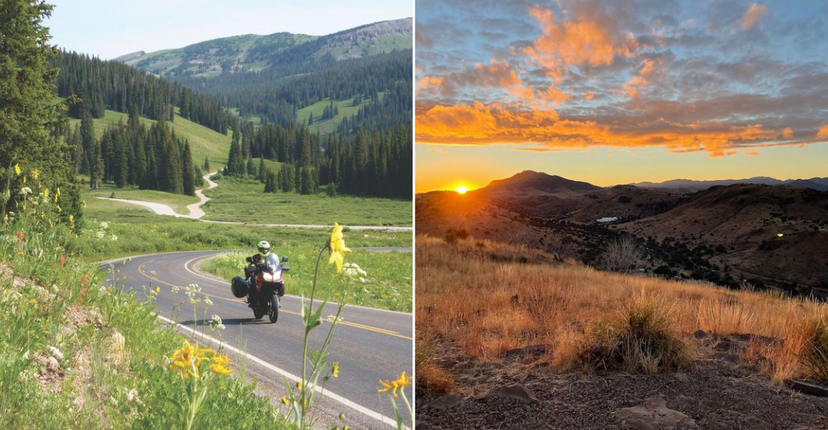
Twisted Sisters Scenic Loop, Leakey Medina Camp Wood
Morning light pools in the canyons and the air smells like cedar and warm limestone. Locals call FM 335, 336, and 337 the Twisted Sisters, a Hill Country loop famous with riders yet surprisingly peaceful on weekdays.
The loop starts near Leakey, passes Medina and Camp Wood, and returns in a rugged clover of ridgelines. The roads climb limestone escarpments that frame ranch gates and windmills.
Go slow, especially at dusk when deer step out like shadows. Spring wildflowers bloom hard, fall is crisp and bright, and summer floats by if you stop to wade the Frio.
River Road FM 170, Presidio To Terlingua
Heat shimmers above low ocotillo, and the Rio Grande flashes silver between basalt outcrops. This is FM 170, River Road, a slithering ribbon from Presidio to Terlingua that hugs Big Bend Ranch State Park.
Survey history lingers in old ranch sites and the adobe walls near Lajitas. The Contrabando movie set area, though minimal now, still marks the cinematic bend. Roadside geology tells a volcanic past in chocolate and rust.
Carry water, fuel up in Presidio or Study Butte, and drive sunrise or late afternoon for soft light. Short hikes at Closed Canyon or Hoodoos make the curves even sweeter.
Davis Mountains scenic loop, Fort Davis
Cool air drifts across the high desert as the Davis Mountains open into rolling volcanic ridges. It’s one of the few places in Texas where the elevation creates a crisp, high-country feel. The road moves gently, almost meditatively.
Fort Davis’s past as a frontier military post shows up in low stone walls and preserved buildings. The land around it feels unchanged, which makes the drive oddly timeless.
Night drives are rare but memorable because this region holds International Dark Sky Reserve status. Most visitors circle back in daylight and finish with a stop at the McDonald Observatory.
Willow City Loop And Enchanted Rock Backroads, Fredericksburg Llano
Spring wildflowers transform these roads into a wave of color that rolls between granite domes and low creeks. Even without blooms, the ranchland feels calm and wide open, perfect for a slower pace.
German farming history shapes the entire region, from old limestone homes to family plots still managed by descendants of early settlers. Enchanted Rock sits at the center like a guardian of these stories.
Crowds peak on weekends, so weekday mornings are the easiest time to make the loop without long lines. The small turnouts give just enough room for safely pulling over to stare at the landscape.
Big Bend Quiet Rim Drives, Panther Junction To Santa Elena Canyon
Wind smells like creosote after a desert sprinkle, and the Chisos stand like a stage set. From Panther Junction, the Ross Maxwell Scenic Drive cruises ridgelines on the way to Santa Elena Canyon. Each overlook stacks mesas until the river cuts a final, clean line.
The route showcases 20th-century ranch remnants, dry lava flows, and broad alluvial fans. Sam Nail Ranch and the Castolon area frame human-scale history against big space. Shade is rare but the geology is generous.
Pack water and snacks, add the Chisos Basin spur if temps allow, and time it for late-day glow. I stop at Sotol Vista to watch shadows ladder the desert, then roll to the canyon for echoing quiet.
Marfa Alpine High Desert Wander Route, Marfa Alpine
Heat shimmers across the flats while distant peaks frame the far edges of the route. The atmosphere feels dreamy, almost surreal, as trains rumble quietly through the basin.
Railroad history defines both towns, shaping their early growth as supply centers. Old depots, warehouses, and cattle-yard remnants still sit near the tracks, reminders of when these towns pulsed with frontier trade.
Travelers typically linger for coffee or galleries in Marfa before drifting toward Alpine for dinner. Sunrise is the best time to see the desert shift from cool blue to bright gold.
Caddo Lake And Jefferson Piney Woods Run, Karnack Jefferson
Cypress knees poke from tea-colored water, and the air smells like wet leaves. Backroads from Karnack to Jefferson edge Caddo Lake’s maze, where Spanish moss softens every branch. Paddles whisper in the boat lanes while birds check the shallows.
Steamboat-era Jefferson once thrived as an inland port, and its brick downtown still shows it. The Caddo Lake State Park CCC cabins sit among pines and curve-roof architecture. Boardwalks bring you eye-level with dragonflies.
Best in fall for color or spring for birdlife, with summer mornings offering quiet. Launch at Big Cypress Bayou, then cruise FM 2198 and 134 for shaded turns. Bring bug spray, patience, and a camera with a good strap.
Caprock Canyons Canyon Sweep, Quitaque
Mist settles low over the cypress swamp at Caddo Lake, creating a feeling closer to a fairytale than a Texas drive. Spanish moss hangs motionless until a breeze stirs it.
Jefferson’s preserved 19th-century buildings show how river trade once made it one of the busiest towns in the state. You sense that past in the brick streets and waterfront traces.
Most visitors rent kayaks in the morning, then take the backroads toward Jefferson for lunch and antique shops. Fall is especially stunning when the cypress leaves glow in deep copper tones.
Palo Duro Canyon And Highway 207 Drop In, Canyon Claude
Wind combs the grasslands, then the earth falls away. Highway 207 south of Claude dives into Palo Duro tributaries, offering overlooks with almost no crowds. Colors stack rust, tan, and juniper green in tidy bands.
CCC-era work shaped Palo Duro Canyon State Park’s access and classic picnic shelters. The nearby Route 66 towns left a roadside culture that lingers in Amarillo and Claude. Erosion writes the geology lesson in plain view.
Pair the 207 drop with the park’s Scenic Drive and a short hike to Lighthouse Trail early. Fuel in Canyon or Claude, and expect big sky weather. Storm light makes photographs hum; clear mornings feel surgical.
Lost Maples To Garner State Park River Road, Vanderpool Concan
Water glass-clinks over limestone ledges and sycamores wink pale green. The route from Vanderpool to Concan follows FM 337 and nearby lanes between Lost Maples and Garner State Park. River bends flash sapphire where the Frio and Sabinal run clear.
Autumn color at Lost Maples comes from Uvalde bigtooth maples, a Hill Country outlier. Garner’s New Deal architecture sets picnic tables under stout stonework. The drive holds a long thread of family vacations and quiet swims.
Visit weekdays in fall, or aim for winter’s empty paths and bright light. Pack river shoes, reserve day-use if plans include Garner, and keep an eye for low-water crossings. Shade and cool water reward an unhurried pace.
Matagorda Bay Slow Coast Drive, Bay City Matagorda
Salt air rides low across cordgrass and the gulls keep count. From Bay City, FM 521 and 2031 wander to Matagorda, ending at the Colorado River mouth and long beach access. Marsh light turns metallic before sunset.
Shipping and rice history inform Bay City’s tidy grid and the river’s engineered jetties. The Matagorda Bay Nature Park adds trails, dune boardwalks, and a view across the estuary. Terns and pelicans arrow past with purposeful quiet.
Check wind forecasts, bring sun protection, and air down tires only where permitted. I like lingering on the river pier to watch tide lines shuffle. Winter birding is stellar; summer evenings feel wind-polished and warm.
Llano River And Castell Country drift, Llano Castell
The river slides over granite slabs in a soft, steady rhythm. Low-water crossings give glimpses of clear pools and smooth rock beds carved by centuries of flow.
Settler history appears in Castell’s old trading buildings, some of which still operate as community hubs. The tiny town holds an unexpectedly strong sense of identity.
Visitors usually fish, picnic, or simply linger by the riverbanks. The light in late afternoon turns the granite warm and pink, making the whole area feel serene.
Lake Buchanan And Inks Lake Calm Water Run
These lakes sit in broad basins surrounded by rolling hills and rocky points. The water stays surprisingly still, offering perfect reflections in early morning.
Hydroelectric history shapes the region, with Buchanan Dam still standing as a major Depression-era engineering project. Its scale adds a touch of grandeur to the quiet shoreline.
Most travelers loop the lakes for scenic stops, then settle into Inks Lake State Park for swimming or short hikes. Sunrise is ideal for spotting herons and watching the first light move across the hills.