This Two-Waterfall Hike In Arkansas Leads To Breathtaking Views
I thought I was just hiking to a waterfall. That would have been enough for me.
Then the trail kept pulling me deeper into the Ozarks, and every turn made it feel like I was getting closer to something I should have known about sooner. The path was not gentle.
Mud grabbed at my shoes. Rocks shifted underfoot.
At one point, I stopped and laughed because the trail was clearly winning.
Then the sound of water got louder.
A few steps later, the whole mood changed. Two waterfalls appeared in the same quiet canyon, dropping into a pool that made the hike feel twice as rewarding.
I stood there longer than planned, mostly because leaving felt rude.
That is the thing about places like this in Arkansas. They do not need a sign bragging about them.
You just have to earn the view, then try not to talk too much.
A Quiet Walk Through The Ozark Woods

Deep forest has a particular kind of silence. I felt it the moment I stepped off Cave Mountain Road and into the tree cover.
The route begins with a steep downhill grade that demands your full attention right away, so trekking poles are genuinely useful here rather than optional accessories.
Tall oaks and hickories press in from both sides, their canopies knitting together overhead to create a shaded tunnel that keeps the air cool even on warm days.
Fallen limbs and loose gravel occasionally interrupt the path, which means watching your footing is a continuous job rather than a casual afterthought.
I noticed that the forest floor was thick with leaf litter, and the earthy smell that rose from it was one of those small pleasures that no photograph can capture.
The access point itself sits along Cave Mountain Road, about 1.1 miles past the Whitaker Point trailhead, with roadside parking that fits only a handful of vehicles, which is exactly the kind of detail that keeps crowds thin on busy spring weekends.
This whole stretch is the opening chapter of the experience known as Compton’s Double Falls in Kingston, AR 72742.
Where The Creek Slips Beneath The Bluffs

The sound of water is one of the oldest trail guides in the book, and Whitaker Creek makes itself known long before you can see it.
The creek carves a winding path through the canyon below, and reaching it requires a descent that feels steeper on the return trip than it does going down, which is a universal truth of hill country hiking.
Once I was creek-side, the bluffs rising on either side created a natural amphitheater where every splash and gurgle echoed with surprising clarity.
The stone walls are layered with different shades of tan and rust, stained by decades of moisture seeping through cracks that ferns and mosses have quietly claimed as home.
Whitaker Creek is also the corridor that connects several waterfalls in the area, including Amber Falls at roughly 18 feet and Owl Falls at approximately 20 feet, both close enough to consider if conditions are safe.
The creek bank requires some boulder hopping, and I found that moving slowly and reading the rocks before stepping made the difference between staying dry and not.
The bluffs here frame every view like a painting that keeps changing as you move downstream.
Mossy Rocks And Clear Mountain Water

I knelt down next to Whitaker Creek and pressed my hand against a moss-covered boulder, genuinely surprised by how cold the water was even in late spring afternoon.
The rocks along this stretch are coated in thick, vivid green moss that gives the entire canyon a lush, almost tropical quality that feels at odds with the rugged Arkansas hillside above it.
That contrast is part of what makes the hike so visually interesting, because the scenery shifts every few hundred feet as you move through different pockets of shade and light.
Clear mountain water is not just a poetic description here; you can actually see individual pebbles resting on the streambed several feet below the surface, which tells you something about how clean and undisturbed this watershed is.
The Upper Buffalo Wilderness designation helps protect this area from development, which is one reason the creek still feels clear and untouched at nearly every bend.
I stopped at a flat rock midstream and just watched the current for a few minutes, which is the kind of pause that a busy schedule rarely allows.
Moments like that are quietly restorative in ways that are hard to explain until you have experienced one yourself.
A Hidden Pool Below The Falls

The base of Compton’s Double Falls takes some extra effort to reach, and a few hikers I spoke with afterward admitted they never found a way down to the pool, which only made me feel a little better about my own careful scrambling skills.
The pool itself sits in a natural bowl carved by decades of falling water, and its color is a striking blue-green that looks almost unreal when the light hits it from above.
At the edge of that pool, looking straight up at the falls dropping approximately 39 to 40 feet overhead, the whole canyon suddenly feels taller and much more dramatic than expected.
The spray from the falling water keeps the surrounding rocks perpetually damp, which explains the dense moss growth and the cool microclimate that hovers around the base even on warm afternoons.
After a good spring rain, the pool fills noticeably and the falls run with real force, splitting into two distinct streams as the water carves through thick slabs of stone on its way down.
At the water’s edge, I counted a couple of different bird calls echoing off the canyon walls, none of which I could confidently identify.
That hidden pool rewards the hikers who commit fully to the scramble, and it absolutely earns its reputation.
Forest Shadows Along The Waterline

Late morning light behaves differently inside a canyon. It arrives in thin shafts that shift across the water and rocks as the sun moves, turning the creek into something that feels almost theatrical.
I noticed that the shadows along the waterline created natural patterns on the streambed, and I spent an embarrassingly long time just watching those patterns drift and change.
The tree canopy along Whitaker Creek is dense enough that even on a bright day, the canyon floor stays mostly shaded, which is a genuine comfort during summer hikes when the open hillside above bakes in the heat.
That shade also supports a rich understory of ferns and wildflowers that crowd the banks and give the route a lush, overgrown character that feels distinctly wild rather than managed.
The base of the falls looked really green when I reached it, and the tree canopy above added to the charm in a way that felt immediate rather than staged.
The interplay of light and shadow here is one of those details that photographs partially capture but never fully convey, because the movement and the sound are essential parts of the picture.
Forest shadows along a waterline have a way of slowing a person down, and slowing down is often the whole point of a hike like this.
Rugged Beauty In The Upper Buffalo Wilds

The Upper Buffalo Wilderness is one of those protected areas that earns the word wilderness without any quotation marks, and the terrain around Compton’s Double Falls makes that point clearly.
Designated wilderness status means no motorized vehicles or manicured trails inside the wilderness boundary, which translates directly into the raw, unfiltered experience that draws serious hikers to this corner of Newton County, Arkansas.
The hike ranges from approximately 2.1 to 3 miles round trip depending on how much exploring you do, but the elevation change and the rugged footing make it feel considerably longer than those numbers suggest.
Sections of the route qualify as a bushwhack, meaning the path occasionally disappears for long stretches and you rely on landmarks and creek crossings to keep moving in the right direction.
Steep dropoffs exist in certain areas, and slick rock surfaces after rain demand careful footwork and a respect for the terrain that experienced hikers develop over time.
The waterfall is named after Neil Compton, a conservationist who worked tirelessly to protect the Buffalo River as a free-flowing natural resource, and hiking through this wilderness feels like a quiet tribute to that effort.
Rugged country like this does not apologize for being difficult, and that honesty is a large part of its appeal.
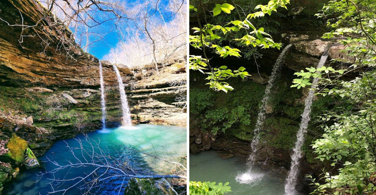
Twin Streams Falling Through Stone

The defining feature of this waterfall is right there in its name, and seeing it in person makes the explanation click in a way that reading about it simply cannot match.
Over a very long period of time, water has carved two separate slots through thick slabs of sandstone, and during high water flow those slots channel the current into two distinct streams that shoot outward and drop roughly 40 feet into the pool below.
A visit after a strong spring rain, when the creek is moving well, is the standard advice from nearly everyone who has made this hike, because low water levels reduce the double-stream effect significantly and can leave the falls looking more like a trickle than a spectacle.
At the rim of the falls, both streams arc outward before disappearing into the mist below, and the view asks for a moment of stillness before the camera even comes out.
The stone around the slots is worn smooth by years of water pressure, and the contrast between that polished surface and the rough canyon walls surrounding it is a small geological detail worth noticing.
I went on a Monday morning after a weekend of rain, and I had the entire scene to myself for nearly an hour.
Twin streams falling through stone is a sight that stays with you long after the mud dries on your boots.
A Peaceful Corner Of Waterfall Country

This region has a quiet reputation as waterfall country, and the stretch of the Ozark National Forest around Kingston confirms that reputation without needing to raise its voice.
What struck me most on the walk back out was how completely alone I felt throughout the entire experience, having encountered zero other hikers from the moment I left the road to the moment I returned.
That solitude is partly a product of the access, since Cave Mountain Road is rough, the access point has no formal signage, and the hike itself filters out casual visitors fairly quickly.
The result is a corner of the Ozarks that still feels secluded, even though it holds some of the most visually striking waterfall scenery in the entire state.
Pair this hike with nearby Hawksbill Crag, also called Whitaker Point, and you get a full day of Ozark wilderness that covers both dramatic overlooks and canyon waterfall scenery in a single outing.
The best conditions arrive after a good rain, ideally in spring or fall when the foliage and water levels conspire to make everything look its absolute finest.
A peaceful corner of waterfall country is not always easy to reach, but the ones that ask the most of you tend to give the most back, and Compton’s Double Falls is a textbook example of that trade.