This 22-Mile Washington Bike Trail With Farmland, Forest Views, And A Small-Town Treat Stop Is Perfect For May
Ever had one of those days where everything just clicks? That’s what happened to me on this incredible trail system that feels like Washington’s best-kept secret, though honestly, with views this stunning, it’s a wonder more people aren’t talking about it.
Rolling along 22 miles of beautifully maintained path, I found myself pedaling past scenes that belonged on postcards-farm fields dotted with content livestock, towering trees that have witnessed generations pass by, and glimpses of mountain peaks that made me stop every few miles just to stare.
The real surprise came when I rolled into a delightful small town along the route, where a certain bakery (okay, let’s just say my pants got significantly tighter that day) offered the perfect excuse to rest and refuel.
Where The Trail Begins: East Puyallup To McMillin

Foothills Trail at its East Puyallup trailhead feels like pressing a reset button on the week. The path stretches ahead, wide and smooth, flanked by open fields that still carry the legacy of the region’s famous daffodil bulb farming.
Spring makes this opening stretch especially rewarding, with green crops pushing up and the air carrying that clean, earthy smell that only exists right after rain.
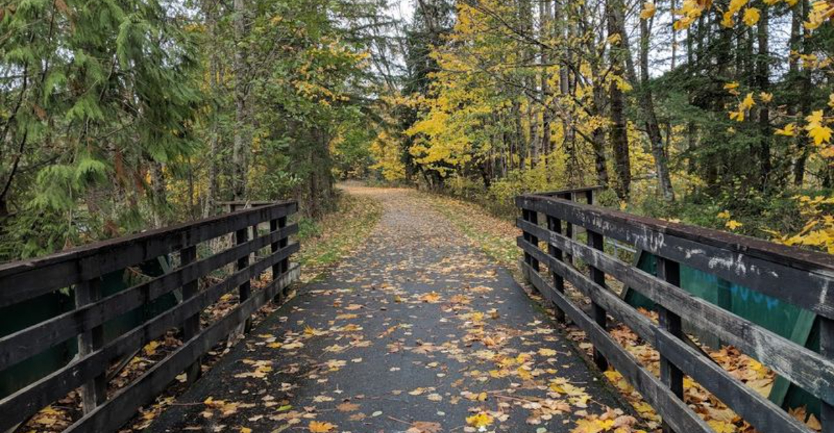
The trail surface is 12 feet wide and fully paved, which means you can ride comfortably side by side with a friend or family member without worrying about gravel patches or ruts.
Cyclists, walkers, inline skaters, and wheelchair users all share this well-maintained path, and the vibe is friendly and relaxed throughout.
By the time you roll through McMillin, you have already covered several miles and your legs are warmed up perfectly. The surrounding landscape shifts gradually from open farmland to a mix of residential neighborhoods and tree-lined sections, giving the early miles a satisfying variety.
The Farmland Stretch And Its Daffodil History

Few people realize that the flat, fertile fields lining the trail near Puyallup were once one of the most productive daffodil bulb growing regions in the entire country.
The Puyallup Valley earned its reputation through decades of flower farming, and while commercial daffodil production has changed over the years, the wide open fields remain and give the trail a pastoral, almost cinematic quality in May.
Riding through this section on a clear spring day, you get long unobstructed sightlines across the valley floor, with Mount Rainier anchoring the eastern horizon like a painted backdrop. The flatness of the terrain here makes it genuinely easy pedaling, so you can spend more time looking around than grinding gears.
Families with younger riders or beginners tend to love this stretch because the low elevation change keeps everyone comfortable. Pack a snack, pause at one of the open pullout areas, and take a long look at that mountain view before rolling onward toward Orting.
Arriving In Orting

Orting sits roughly in the middle of the Foothills Trail corridor, and it earns its reputation as the trail’s social hub with a lineup of local spots that reward tired legs.
The town is a proper small valley community, and it has a personality that feels genuinely welcoming rather than tourist-polished.
You can find a bike shop here if you need a quick tune-up or a tube replacement, which is genuinely useful to know before you head out.
Cafes, bakeries, and a diner serving full breakfasts make Orting the obvious midpoint rest stop. Doughnuts, coffee, pizza, and Mexican food are all within easy walking distance of the trail access points.
I stopped here on my May ride and ended up sitting outside a bakery for a solid thirty minutes, watching other cyclists roll through and chatting with a retired couple who had been riding this trail every spring for eight years.
That kind of easy community spirit is hard to manufacture and impossible to skip.
Forest Views And Riverside Riding

Once you leave Orting heading east, the character of the trail changes completely and dramatically. The path begins following the Carbon River upstream, and the landscape trades open farmland for something much more dramatic.
Dense Pacific Northwest forest with towering Douglas firs and cedars crowding the trail on both sides. This section delivers some of the most photogenic riding on the entire route.
The river runs alongside the trail in several places, and the combination of rushing water sounds, cool shade, and filtered green light through the forest canopy creates a sensory experience that is genuinely hard to describe without sounding like you are overselling it. You are not overselling it.
Mount Rainier views open up at several clearings along this stretch, and the unobstructed sightlines toward the mountain are arguably the best on the entire trail.
Bring a camera or at minimum make sure your phone is charged, because the temptation to stop and photograph every other bend in the river is very real and completely justified.
Mount Rainier Views Along The Route

Mount Rainier is the undeniable star of this trail. At 14,411 feet, the mountain dominates the southeastern horizon for much of the route, and on a clear May day when the snowpack is still thick and bright, the views are genuinely jaw-dropping.
Spring is particularly rewarding because the lower valleys are green and lush while the upper mountain remains fully snowcapped, creating a contrast that looks almost too beautiful to be real.
The clearest views tend to appear in the sections between Orting and South Prairie, where the terrain opens up and tree cover thins. Early morning rides offer the sharpest visibility before any afternoon cloud buildup, so if you can start your ride by 8 or 9 in the morning, do it.
Experienced trail users recommend checking the weather forecast the night before and choosing a day with low humidity for the best mountain views. A pair of sunglasses is essential in May when the sun reflects off the snowfields and the glare can be surprisingly intense even from a distance.
A Quiet Espresso Stop Worth The Detour

About five miles west of Buckley, the small community of South Prairie offers one of the trail’s quieter and more charming stop options. This is not a bustling town center, and that is exactly the point.
South Prairie has the kind of unhurried pace that makes you want to slow your own cadence just to match it. Local espresso stands serve up coffee and treats that hit differently when you have already put ten or twelve miles into your legs.
A good flat white and a pastry at a roadside stand surrounded by rural Washington scenery is one of those simple pleasures that sticks in your memory long after the ride is over.
The community itself is small enough that you will likely recognize the same faces if you stop on the way out and again on the way back. That kind of small-town familiarity is rare and refreshing. South Prairie is proof that the best trail stops are not always the biggest ones on the map.
Buckley And The White River Terminus

The eastern end of the Foothills Trail terminates at the White River in Buckley, and rolling into this endpoint gives you a satisfying sense of completion that only comes from actually finishing something.
Buckley is a small city with a working-town feel, not overly polished or touristy, and it has a straightforward charm that fits the overall spirit of the trail perfectly. The White River itself is worth a few minutes of your time before you turn around for the return trip.
The river runs cold and clear in May, fed by snowmelt from the Cascades, and watching it move through the valley is a good reminder of just how close to genuine wilderness this trail actually sits.
Buckley also has food and coffee options if you want to refuel before heading back west. The round trip from East Puyallup to Buckley covers roughly 44 miles, which is a solid full-day ride.
Casual cyclists can drive to Orting or South Prairie and do a shorter out-and-back without any loss of scenery.
Why May Is The Sweet Spot For This Ride

Timing a Pacific Northwest trail ride is a genuine skill, and May sits in a narrow window of near-perfection for the Foothills Trail. The Pacific Northwest rainy season begins winding down by late April, and May brings a run of clear, cool days that are ideal for sustained outdoor exercise.
Temperatures typically hover in the mid-50s to mid-60s Fahrenheit, which is perfect cycling weather by almost any standard. Spring wildflowers bloom along the trail margins in May, adding color and fragrance to sections that would look more muted in summer heat or winter gray.
The farmland is actively green rather than dry, and the river levels are high and lively from snowmelt, making the Carbon River sections especially dramatic.
Summer brings more visitors and warmer temperatures that can make midday riding less comfortable. Fall is beautiful but shorter in daylight. May threads the needle between ideal conditions and manageable crowds, giving you long daylight hours, fresh scenery, and the mountain in full winter glory.
The calendar rarely lines things up this well.
Trail Surface, Accessibility, And Who Can Ride Here

One of the most practical things about the Foothills Trail is how genuinely accessible it is. The 12-foot-wide asphalt surface is smooth and well-maintained, making it comfortable for road bikes, hybrid bikes, cruisers, and even adaptive cycles.
Wheelchair users and parents with jogging strollers use this trail regularly, and the design accommodates everyone without feeling cramped.
The elevation profile is mostly flat to gently rolling, which keeps the ride manageable for beginners and younger riders.
There are no technical sections, no steep sustained climbs, and no complicated navigation. The trail is clearly marked throughout, and connecting roads in the small towns help you orient yourself easily.
A soft shoulder path running alongside sections of the main trail is available for equestrians, which adds to the multi-use character of the route.
You may encounter horses on some stretches, and trail etiquette suggests slowing down and giving them a wide berth. The overall experience is relaxed, inclusive, and genuinely family-friendly in a way that many longer trails fail to achieve.
Practical Tips

Getting the logistics right makes the difference between a great ride and a frustrating one. The Foothills Trail has multiple access points along its route, with parking available at trailheads in East Puyallup, Orting, South Prairie, and Buckley.
Arriving early on weekends in May means you will find parking easily and have the quieter morning sections mostly to yourself.
Bring at least two full water bottles, especially if you are planning the full out-and-back distance. While Orting and Buckley have food and drink options, the stretches between towns can be longer than they look on a map when your legs are already tired.
A basic repair kit with a spare tube, tire levers, and a mini pump is worth carrying given how far some sections sit from the nearest bike shop. Cell service is generally reliable along most of the trail, but download an offline map before you go just in case.
Sunscreen is non-negotiable on clear May days, especially during the open farmland sections where shade is minimal and the sun reflects off the pavement.
Future Extensions And The Bigger Trail Vision

The Foothills Trail is not finished growing. Plans are in place to extend the route westward to connect with the Riverwalk Trail in Puyallup, and from there eventually link all the way to Tacoma and Sumner.
On the eastern end, future extensions aim to reach into King County and connect with Enumclaw, creating a much longer continuous corridor through the foothills region.
These planned connections would transform an already excellent regional trail into something genuinely significant for the greater Puget Sound area.
Keeping an eye on Pierce County Parks updates is worthwhile if you plan to return in future years.
The trail network in this region has been expanding steadily, and each new segment tends to add scenic value rather than just raw mileage. The Foothills Trail is already worth the trip, and its best chapters may still be ahead.
Why This Trail Stays With You

Some bike rides are purely physical, a workout with a start and an end point. The Foothills Trail manages to be something more layered than that.
By the time you coast back to your starting point, you have moved through farm history, river wilderness, small-town community life, and mountain grandeur, all in one connected experience that never required a car door or a trail map change.
The small-town stops in Orting and South Prairie are the kind of detail that elevates a trail from good to genuinely memorable. Sitting with a coffee and a doughnut while your legs recover, watching other riders pass through, you feel connected to a place rather than just passing through it.
If you have been looking for a Pacific Northwest bike ride that delivers scenery, accessibility, community, and that specific May magic of everything being green and the mountain being impossibly bright, the Foothills Trail in Pierce County, Washington, is ready and waiting.
Pack your kit, check the forecast, and go.