This Washington Suspension Bridge Hike Comes With Jaw-Dropping Views
Hiking boots are usually for walking, but on this trail, they mostly serve as anchors to keep you from being blown away by the sheer intensity of the scenery. Navigating the rugged path requires a bit of grit, but the reward is a bridge that feels like a portal to another dimension.
Washington possesses a wild, untamed magnetism that draws you into its emerald heart, demanding you trade your comfort zone for a glimpse of raw geological power.
It’s the kind of place where you’ll find yourself laughing nervously at your own audacity while clutching the railing for dear life.
If your bucket list is feeling neglected, this suspension bridge is the perfect wake-up call to remind you that adventure is always worth the shaky knees. I have walked a lot of trails across the Pacific Northwest, but nothing quite prepared me for the raw, volcanic drama waiting here.
The Volcanic Origins That Shaped The Canyon

Back in 1980, Mount St. Helens did not just erupt. It rewrote the entire landscape in a single catastrophic moment.
The massive lahars, or volcanic mudflows, that poured down the mountain scraped away centuries of sediment and exposed raw bedrock, columnar lava formations, and the bones of the earth itself. What was once buried became the dramatic stage you hike through today.
Walking the Lava Canyon Trail means stepping directly into a geology lesson that no textbook could ever replicate.
The dark, angular columns of ancient lava line the canyon walls, and the rushing Muddy River cuts through the center of it all. Interpretive signs along the paved opening section help connect the dots between what you see and the science behind it.
Knowing the backstory makes every step feel more meaningful. You are not just hiking through pretty scenery. You are walking through the visible scar of one of the most significant volcanic events in modern American history, and the canyon wears that story with stunning confidence.
Trail Difficulty And What To Expect Underfoot

Starting out, the trail feels almost welcoming. The first 0.3 to 0.5 miles is paved, relatively flat, and accessible to most visitors, offering early glimpses of the canyon that hint at the spectacle ahead.
But do not let that smooth beginning fool you into thinking the whole route stays that easy. As the trail pushes deeper into the canyon, it shifts into something far more demanding.
The full roundtrip route stretches up to 5.4 miles with roughly 1,168 feet of elevation gain, and AllTrails rates it as moderate, though several sections feel closer to challenging. Narrow ledges, exposed cliff edges, and steep drops appear without much warning, so solid footing and careful attention are non-negotiable.
The trail is not recommended for young children, anyone with a fear of heights, or dogs that cannot be carried through the trickier sections.
Going prepared means wearing proper hiking shoes, bringing enough water, and genuinely respecting the terrain. Confidence on rocky, uneven ground will make the whole experience far more enjoyable.
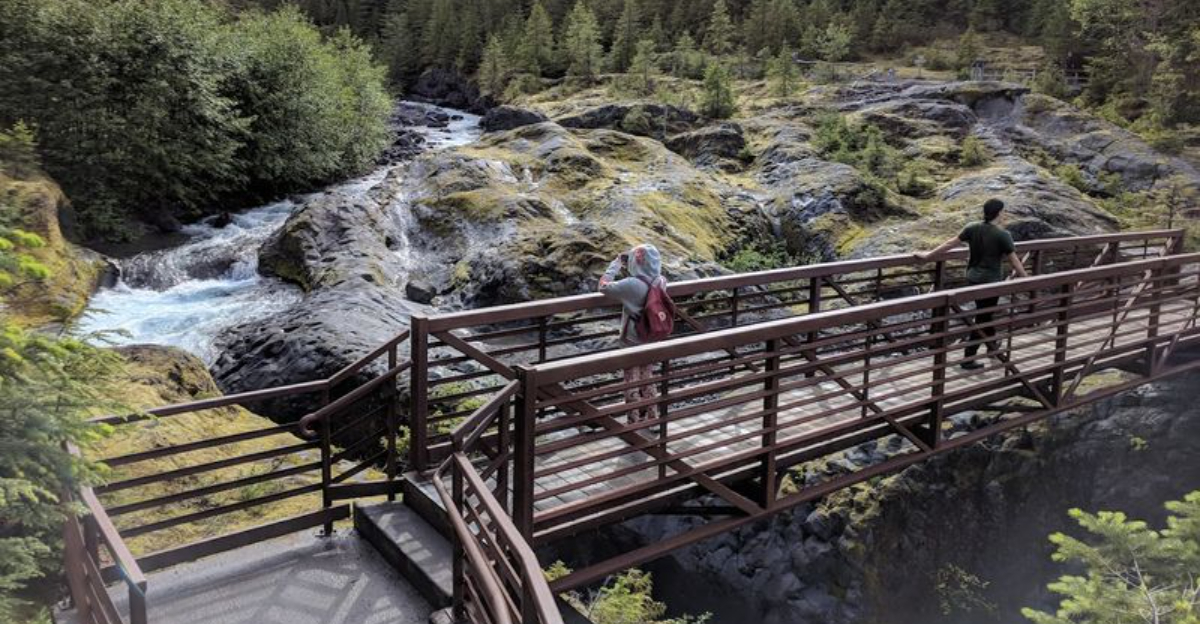
The Suspension Bridge And Its Current Status

Built in 1993, the Lava Canyon Suspension Bridge quickly became the most talked-about feature of the entire trail.
Strung on cables anchored to two 17-foot Douglas fir towers, it crosses directly above Lava Canyon Falls, and hikers who have made the crossing describe it as bouncy and lively, almost trampoline-like beneath their feet.
That combination of height, movement, and roaring water below creates a moment that sticks with you long after the hike is over.
Here is the important update for anyone planning a visit: as of May 2026, the suspension bridge is closed due to structural damage and is considered unsafe for use. The full 1.4-mile upper loop that normally crosses the bridge is not currently passable in its complete form.
However, hikers can still approach the bridge from both sides of the river and view it up close.
Checking current trail conditions before heading out is always a smart move, especially for a trail where a single feature shapes the entire experience. The Forest Service updates closure information regularly on their official site.
Waterfalls And The Views That Stop You Cold

Few trails in Washington deliver waterfalls the way Lava Canyon does. Multiple cascades appear throughout the route, each one tumbling over dark volcanic basalt and filling the canyon with a constant, rolling thunder of water.
The Muddy River runs through the center of the canyon with surprising power, and standing at certain overlooks, you feel the spray of the falls even from a safe distance.
The columnar lava walls frame these waterfalls in a way that feels almost theatrical. The contrast between the dark, angular rock and the white rushing water creates a visual intensity that photographs struggle to capture honestly.
Early morning visits tend to offer softer light and fewer crowds, which makes the scenery feel even more personal.
Beyond the falls, the trail opens up to broader canyon views where layers of volcanic history stretch across the horizon. Each new bend in the trail reveals something different, and the reward for pushing further in is always another view that makes the effort feel completely worth every step.
The Steep Metal Ladder

Right around the point where the trail transitions from scenic to seriously adventurous, a 30-foot metal ladder appears bolted directly into the canyon wall. It is one of those trail features that makes you pause, look up or down, take a breath, and then commit.
The ladder provides the only practical route through this section, and it requires both hands, steady nerves, and a willingness to trust the structure beneath you.
This part of the hike is genuinely thrilling in the best possible way. The canyon walls close in around you, the sound of water amplifies, and the exposure reminds you that this is not a casual stroll through a park. Hikers who push through this section consistently describe it as the highlight of the entire trail.
Sturdy gloves can make the metal rungs more comfortable, especially on cooler mornings when the metal is cold and slick.
Planning to tackle this section when the trail is less crowded also helps, since the ladder is narrow and passing other hikers mid-climb is not a comfortable experience for anyone involved.
Permits, Parking, And The Best Time To Visit

Getting to the trailhead requires a Northwest Forest Pass or a $5 day-use fee for parking, so sorting that out before you arrive saves time and avoids any surprises at the lot.
The trailhead sits within the Gifford Pinchot National Forest near Cougar, Washington, and the access road leading to it closes during winter months, which limits the hiking season considerably.
The sweet spot for visiting runs from late May through October, when the road is open, water levels in the canyon are manageable, and the surrounding forest is alive with color and energy.
Midsummer weekends draw larger crowds, so arriving early in the morning on a weekday gives you the best chance of experiencing the trail without feeling rushed or crowded at the overlooks.
Fall visits offer a particularly rewarding combination of cooler temperatures and changing foliage, which adds warm tones to the already dramatic canyon scenery.
Checking the Mount St. Helens National Volcanic Monument website before your trip ensures you have the most current road and trail conditions, especially given recent closures affecting the suspension bridge.
A little planning goes a long way here, because this is the kind of hike that rewards good timing as much as good shoes.
Tips For Hiking Lava Canyon Safely And Confidently

Lava Canyon has a reputation for stunning beauty, but it also demands genuine respect. Staying on the designated trail is not just a suggestion here. Straying off the marked path in this canyon has resulted in fatalities due to steep, unmarked drops and the raw power of the waterfalls below.
Every safety sign along the route exists for a real reason, and experienced hikers treat those warnings seriously. Wearing a helmet is genuinely worth considering for the more exposed sections, and trekking poles add valuable stability on the steep descents.
Bringing at least two liters of water per person, along with snacks and a basic first aid kit, keeps you comfortable and prepared for the longer route options. Cell service is limited in the canyon, so downloading an offline trail map beforehand is a practical move.
Dogs are permitted on the trail, but owners should honestly assess whether their pet can handle the ladder and narrow cliff sections safely.
The hike rewards those who prepare thoughtfully and approach the terrain with patience, making the experience both safe and deeply memorable from start to finish.