This Washington Trail Is A Stairway Straight Up The Core Of An Ancient Volcano
There’s a special kind of madness embedded in Washington’s landscape, and I found it on a trail that basically said, “Forget hiking-let’s call this vertical cardio.” The path to the top of this ancient volcano doesn’t mess around with gradual elevation gains or scenic valleys.
Nope. Just stairs.
Hundreds and hundreds of them, stacked up the side of an ancient volcanic core like some hiking sadist’s fever dream. My quads start questioning my life choices around step 200. The humor of it hits me somewhere around step 500: I’m voluntarily climbing stairs outdoors when there’s a perfectly good couch back home.
By the summit, I’ve learned that volcanoes are basically Earth’s way of saying, “I can build something so tall your knees will never forgive you.”
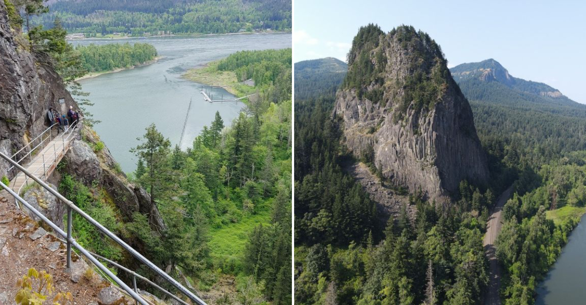
The Geological Marvel Behind Beacon Rock
Most people look at Beacon Rock and see a big rock. Geologists look at it and see one of the most remarkable volcanic remnants on the entire continent. This towering monolith is the solidified magma core of a shield volcano that was active roughly 57,000 years ago.
When the surrounding softer rock eroded away over thousands of years, the hard basalt core was left standing tall. The result is the second-largest freestanding monolith in the United States, trailing only Devils Tower in Wyoming.
That fact alone makes the drive out to Skamania County, Washington, completely worth it. The rock’s dark, jagged surface tells the story of intense heat and pressure, layers of time pressed into every crevice.
Standing at its base and tilting your head back to take it all in is a genuinely humbling moment. You are not just looking at scenery here, you are reading a chapter of Earth’s biography written in stone.
A Trail Unlike Any Other In The Pacific Northwest

The trail up Beacon Rock is not your typical dirt path through the woods. It is a carefully engineered series of 52 switchbacks bolted directly into the side of the rock, stretching about a mile from base to summit.
Metal handrails line nearly the entire route, which makes it accessible to hikers of many skill levels. What makes this trail feel so special is the sense that you are scaling something alive.
Each turn reveals a new angle of the Columbia River Gorge, and the rock face changes character as you climb higher. Some sections feel narrow and dramatic, while others open up into breezy ledges with sweeping views.
The trail was originally constructed between 1915 and 1918 by Henry Biddle, a private landowner who wanted to share the rock with the public.
His vision paid off in the most spectacular way. Today, thousands of hikers make this climb each year, and not a single one walks away without a story worth telling.
What To Expect On The Climb Itself

The hike to the summit covers roughly 1.8 miles round trip with about 600 feet of elevation gain. That sounds manageable, but the trail wastes no time getting steep. Within the first few minutes, you are already gripping handrails and leaning into the incline.
The path is paved in some sections and bare rock in others, so good footwear with solid grip is a smart choice. Younger kids can handle this trail with adult supervision, but strollers and wheelchairs are not a good fit here.
Plan for about 45 minutes to an hour to reach the top at a comfortable pace.
One thing that catches many hikers off guard is the wind. As you gain elevation, gusts can pick up quickly, especially near the exposed upper sections. A light jacket tucked into your pack is never a bad idea.
The effort is real, but the payoff at the top is the kind of view that makes your legs forgive you immediately.
The Views From The Summit

Reaching the top of Beacon Rock feels like stepping onto a natural observation deck placed there just for you. The Columbia River stretches out in both directions, wide and silver, cutting through a landscape of dense evergreen forest and rugged canyon walls.
On a clear day, Mount Hood rises dramatically to the south, and Mount Adams appears to the north. The summit is not a wide flat area, so there is not much room to spread out.
A small viewing platform gives you a safe spot to take it all in without getting too close to the edges. Most hikers spend a good fifteen to twenty minutes up top, turning slowly to take in every direction.
Mornings tend to offer the clearest air and the softest light for photography. The river below catches the early sun in a way that makes the whole scene look almost unreal.
Standing up there, you get a strong sense of just how ancient and powerful this landscape truly is.
History Of The Rock And Its Famous Visitors

Beacon Rock has been a landmark for a very long time. Lewis and Clark noted it in their journals during their 1805 expedition, calling it a significant geographic marker as they traveled down the Columbia River toward the Pacific Ocean.
They recognized it as the point where tidal influence on the river began, marking a major transition in the landscape.
For thousands of years before European explorers arrived, Indigenous peoples of the Columbia Plateau region knew this rock well. It served as a navigation point and a place of cultural significance along the river corridor.
That layered human history adds a quiet depth to every step you take on the trail. In the early 1900s, there were plans to demolish Beacon Rock and use it as fill material for jetties.
Henry Biddle purchased the land to prevent that from happening, and later his family donated it to Washington State. That act of preservation is the reason hikers can still climb it today, which feels like a gift worth appreciating.
Getting There And Park Essentials

Beacon Rock State Park sits along State Route 14 on the Washington side of the Columbia River Gorge, about 35 miles east of Vancouver, Washington.
The address is 34841 SR-14, Skamania, WA 98648, and it is easy to find with a GPS or basic map directions. The park is open year-round, though trail conditions vary by season.
Parking is available in a designated lot near the trailhead, and a Discover Pass is required for Washington State Parks. Day passes can be purchased at the park entrance or online in advance.
Arriving early on weekends is a good strategy, since the lot fills up quickly during summer months. Restrooms are available near the trailhead, and there is a picnic area nearby for a post-hike lunch.
Dogs are welcome on the trail as long as they are kept on a leash. Cell service can be spotty in parts of the gorge, so downloading an offline map before you go is a practical move.
Best Times To Visit And Seasonal Highlights

Spring and fall are widely considered the best seasons for hiking Beacon Rock. In spring, wildflowers bloom along the lower sections of the trail, and the air is cool and crisp without the summer crowds.
Fall brings a spectacular show of orange and gold foliage that makes the Columbia River Gorge look like a painting.
Summer visits are popular but come with more foot traffic and warmer temperatures. If you go in July or August, an early morning start makes a big difference in both comfort and crowd levels.
Midday heat on exposed rock sections can be intense, so packing extra water is essential. Winter hikes are possible on dry days, but the trail can become slippery with ice or frost on the metal grates and rock surfaces.
Some visitors find the off-season visits especially peaceful, with far fewer people sharing the summit views. Whatever time of year you choose, checking current trail conditions through Washington State Parks before heading out keeps the experience smooth and safe.
Making The Most Of Your Visit Beyond The Summit

The summit hike gets all the attention, but Beacon Rock State Park has more to offer once you come back down. The park includes several other trails, campgrounds, and a boat launch along the Columbia River.
Hardy Creek Trail and the Hadley Peak trail system offer longer routes for hikers looking to extend their day.
Camping is available both on the Washington side and nearby in Oregon, making it easy to turn this into a weekend trip rather than just a day outing.
Fishing along the river is popular in season, and the boat launch area draws kayakers and paddleboarders who want to see the rock from the water.
The Columbia River Gorge National Scenic Area surrounds the park, meaning the scenery does not stop at the park boundary.
Nearby attractions like Cape Horn Trail and the Bridge of the Gods in Cascade Locks, Oregon, are worth adding to your itinerary. This area rewards slow travel, so give yourself at least a full day to soak it all in properly.